Matrice 400 on a Mountain Coastline: A Field Case Study
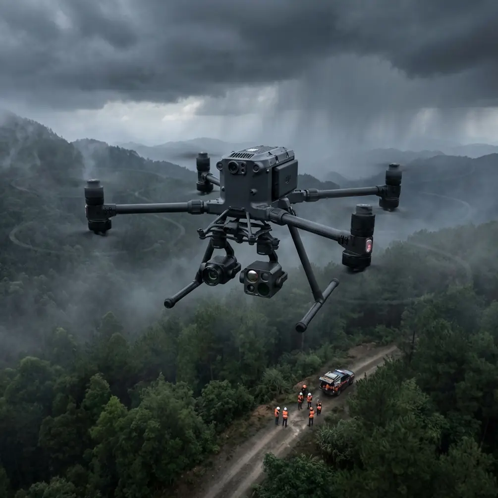
Matrice 400 on a Mountain Coastline: A Field Case Study in Wind, EMI, and Data Integrity
META: Expert case study on using the Matrice 400 for coastline capture in mountainous terrain, with practical insights on O3 transmission, antenna adjustment, thermal workflows, photogrammetry, GCP strategy, hot-swap batteries, AES-256, and BVLOS planning.
By Dr. Lisa Wang, Specialist
A mountain coastline looks beautiful from the ground. From an operational standpoint, it is one of the least forgiving places to fly a professional drone.
You are dealing with abrupt elevation changes, reflective water, salt-heavy air, shifting wind bands, and radio noise from cliffside infrastructure, telecom towers, vessels, and power distribution corridors. Add the need to capture clean visual data, reliable thermal signature information, and survey-grade geometry for photogrammetry, and the mission stops being a simple shoreline flight. It becomes a systems test.
That is where the Matrice 400 earns attention.
This article is not a generic platform overview. It is a field-based look at how the Matrice 400 fits a very specific civilian mission profile: documenting a mountainous coastline where the client needed orthomosaic mapping, thermal review of rock faces and drainage paths, and repeatable data collection windows across several tide states. The value of the aircraft was not in one headline specification. It was in how several design choices worked together under pressure.
The assignment: one site, three data problems
The target area combined steep coastal ridges with narrow access points and a long stretch of irregular shoreline. The engineering team wanted three outputs.
First, they needed photogrammetry-grade visible imagery to model cliff retreat, access paths, and drainage channels. Second, they wanted thermal passes at dawn to identify moisture retention zones and possible delamination on exposed surfaces. Third, they needed a workflow that could support longer operational days without repeatedly shutting the aircraft down between payload changes and battery cycles.
That mix matters because coastline jobs often fail at the handoff between disciplines. Survey wants overlap and geometry. Inspection wants angle control and repeatability. Environmental teams want thermal data gathered inside a narrow time window. If the aircraft cannot move smoothly between those needs, the mission schedule expands, and so does risk.
The Matrice 400’s advantage in this scenario came from integration discipline: transmission reliability, battery continuity, payload flexibility, and secure handling of sensitive site data.
Why mountain coastlines are hard on links, not just airframes
Most pilots expect wind trouble first. In reality, link stability often becomes the hidden limit.
On this site, the aircraft had to work along a cliff line where the operator’s visual position changed relative to the aircraft as it rounded outcroppings and crossed shallow coves. Water reflection and uneven terrain can distort signal behavior. Add electromagnetic interference from ridge-mounted communications equipment, and even a capable platform can feel inconsistent if the ground side is not managed carefully.
This is where O3 transmission became operationally meaningful, not just a brochure term. In a mountainous coastline environment, strong transmission is not about flying farther for the sake of distance. It is about maintaining stable command-and-control and video feed quality while terrain and reflective surfaces create moment-to-moment signal complexity.
The practical lesson from this mission was simple: antenna adjustment was not a minor habit. It was part of flight discipline.
At one ridge transition, signal quality dipped as the aircraft moved laterally behind a protruding rock shoulder. The issue was not a platform failure. It was geometry. The remote antenna orientation had not been updated to match the aircraft’s changed bearing and elevation relationship. After a deliberate antenna correction—aligning for the aircraft’s actual flight path rather than its previous position—the link stabilized. That prevented a conservative abort and preserved the data run.
That small moment says a lot about real operations. Even with robust transmission architecture, human antenna management still matters in EMI-heavy coastal terrain. Operators planning similar missions should treat antenna position as a live control input, especially near cliffs, towers, and marine infrastructure.
Thermal signature capture: timing matters more than volume
The thermal requirement was not to produce dramatic imagery. It was to extract useful differences.
On rocky coasts, thermal signature interpretation can be misleading if flights are conducted too late in the day. Sun loading can flatten the contrast between structurally interesting features and surrounding surfaces. In this case, dawn operations gave the best chance of identifying moisture retention lines and subtle temperature anomalies along fractured rock and drainage exit points.
That sounds straightforward until you layer in geography. Mountain shadows move unevenly, and the coastline presents surfaces at multiple angles to the sun and wind. A thermal pass over a shaded cove and one over a sun-touched ridge can produce very different readings even within a short interval.
The Matrice 400 platform was useful here because the aircraft could support a disciplined multisensor workflow rather than forcing the crew into fragmented sorties. When the thermal team can stay on schedule, gather repeatable passes, and move quickly into visible-light documentation while conditions remain stable, the quality of interpretation improves.
Thermal data on its own can be seductive and wrong. Thermal data tied immediately to high-quality visual capture and mapping control becomes actionable.
Photogrammetry on cliffs: where GCP planning decides the project
A lot of operators talk about overlap percentages and camera settings. Along a mountain coastline, the bigger issue is control.
Photogrammetry near cliffs suffers when the mission relies on flat-ground assumptions. Elevation changes, variable surface texture, and inaccessible ledges can distort the model if control is weak or poorly distributed. GCP placement had to be adapted for this site rather than copied from a normal road or open-field survey.
The field team used GCP positions that addressed both shoreline continuity and elevation variance. The point was not simply to add more markers. It was to create geometric stability across breaks in terrain. Cliff-top control without lower-elevation references can leave parts of the model less trustworthy. Shoreline-only control can do the same in reverse. Balanced placement improves reconstruction confidence, especially where rock faces interrupt visual continuity.
This is where the Matrice 400 mission profile helped again. The aircraft could hold a repeatable flight plan over a difficult area while collecting imagery with enough consistency to support downstream processing. In a place where wind funnels change quickly, stable and predictable capture matters as much as raw image count.
For teams producing coastal orthomosaics and 3D models, the operational significance is clear: the aircraft is only one part of survey accuracy, but a stable platform reduces one of the biggest sources of error—uneven acquisition caused by terrain and weather pressure.
Hot-swap batteries changed the tempo of the day
Battery management on a mountain coast is not glamorous, but it decides how much useful work gets done.
Access points were limited. Hiking equipment between staging areas would have consumed time and narrowed the thermal collection window. A platform that can support hot-swap batteries has an immediate field advantage in this setting. The crew could cycle power modules efficiently and keep the aircraft workflow moving without unnecessary system resets and long interruptions.
That matters for two reasons.
First, environmental conditions on coasts are transient. Tide, light angle, mist, and wind do not wait for a ground crew to rebuild momentum. Second, every stop-start cycle introduces opportunities for checklist drift, payload handling errors, or delayed launch timing. Hot-swap batteries reduced those breaks and kept the mission inside its intended sequence.
This was especially useful on a long documentation day where the team moved from thermal passes to visible mapping and then to selective inspection runs on specific cliff segments. Instead of treating each phase like a separate mission, the Matrice 400 supported continuity.
That continuity is one of the underappreciated productivity gains in industrial drone work. Faster turnover is not about speed for its own sake. It protects the logic of the data collection plan.
AES-256 and why security belongs in the field conversation
Coastal projects often involve more than scenery. The site may include infrastructure corridors, utility routes, geological risk zones, or private facilities. When teams discuss aircraft capability, they often leave out transmission and data security until procurement asks the question late in the process.
That is backwards.
AES-256 matters because professional drone operations increasingly sit inside larger compliance frameworks. Even when the mission is civilian and environmental, the collected imagery can be operationally sensitive. Secure transmission and secure handling are part of modern field readiness, not an IT afterthought.
On this project, secure workflows were especially relevant because the imagery covered both natural shoreline and adjacent assets. The platform’s support for AES-256 helped satisfy the client’s expectation that data transport and command links would align with enterprise-grade security practices. For teams working with consultants, utilities, environmental agencies, and private asset owners, that can be the difference between approval and delay.
Security does not improve image quality, but it does improve deployability. And deployability is what gets missions off the planning board and into the air.
BVLOS thinking without casual shortcuts
BVLOS is often discussed too loosely. On a mountainous coastline, that is a mistake.
Even where BVLOS planning is part of the operational concept, the environment demands disciplined risk assessment. Terrain masking, changing weather, vessel traffic, and radio complexity all need to be accounted for. The Matrice 400 is relevant to these conversations because its transmission and enterprise architecture support more advanced operations planning. But no serious operator should treat that as permission to ignore local regulations, observer requirements, or airspace procedures.
What the platform does offer is a stronger foundation for corridor-style coastal work where extended shoreline capture may otherwise become inefficient. For infrastructure monitoring, erosion tracking, habitat documentation, and repeat survey work, that matters. A better aircraft does not erase operational responsibility. It makes disciplined execution more realistic.
What stood out after the mission
Three things.
First, the Matrice 400 handled the coastline assignment best when it was treated as a systems platform rather than a flying camera. The strongest results came from combining thermal, mapping, and inspection logic into one coherent workflow.
Second, O3 transmission delivered its value in signal resilience, but that value depended on operator behavior. Antenna adjustment in the presence of electromagnetic interference was not optional housekeeping. It was central to maintaining flight continuity along ridges and around rocky protrusions.
Third, hot-swap batteries had an outsized effect on mission quality. They preserved timing, especially during dawn thermal collection and back-to-back mapping runs. In the field, mission rhythm is a performance variable. The aircraft supported that rhythm well.
For teams planning similar work, the takeaway is not simply “use a larger enterprise drone.” It is to build a capture plan that respects the coastline as a difficult electromagnetic and geometric environment. Put GCPs where the terrain actually needs them. Schedule thermal flights around real surface behavior, not convenience. Treat antenna orientation as a live variable. Keep battery turnover tight. Secure the data path from the outset.
If you are scoping a similar coastal mapping or inspection job and want to compare workflow options, you can reach out directly on WhatsApp for field planning notes.
The Matrice 400 fit for this kind of coastline work
The Matrice 400 makes sense for mountain coastline capture because the mission asks for more than endurance or image quality in isolation. It asks for operational consistency under mixed demands.
You need transmission you can trust when cliffs and water complicate the link. You need secure communications when the site overlaps with sensitive infrastructure. You need a battery workflow that does not waste the best environmental window. You need a platform that supports thermal signature capture and photogrammetry in a way that preserves time, geometry, and context.
That was the real story here.
The aircraft did not simplify the coastline. Nothing does. What it did was reduce the number of compromises the team had to make while working inside a difficult environment. In professional drone operations, that is usually the difference between impressive footage and usable results.
Ready for your own Matrice 400? Contact our team for expert consultation.