Capturing Remote Coastlines with Matrice 400
Capturing Remote Coastlines with Matrice 400: Field Methods That Match Where the Drone Industry Is Headed
META: A practical Matrice 400 tutorial for remote coastline work, covering integration, interference testing, photogrammetry planning, thermal workflows, transmission reliability, and field-ready inspection habits.
Remote coastline work exposes every weak habit in a drone program.
Salt spray creeps into connectors. Wind changes by the minute. GNSS can get messy around cliffs. Access roads disappear. And when the aircraft is several kilometers downshore over rock shelves or tidal zones, “good enough” planning stops being good enough.
That is exactly why the Matrice 400 matters right now.
At XPONENTIAL 2026 in Detroit, AUVSI President Michael Robbins described a broader shift across the drone sector: the industry is moving away from pure experimentation and into integration. That framing is useful for anyone evaluating the Matrice 400 for coastal operations. The real question is no longer whether a drone can technically capture shoreline imagery, thermal data, or survey-grade outputs. The question is whether the aircraft, payloads, workflow, power strategy, and test discipline hold together as one reliable system when the site is remote and the margin for error is thin.
For coastline teams, the Matrice 400 should be judged in that integrated way.
Why remote coastline jobs demand more than a long spec sheet
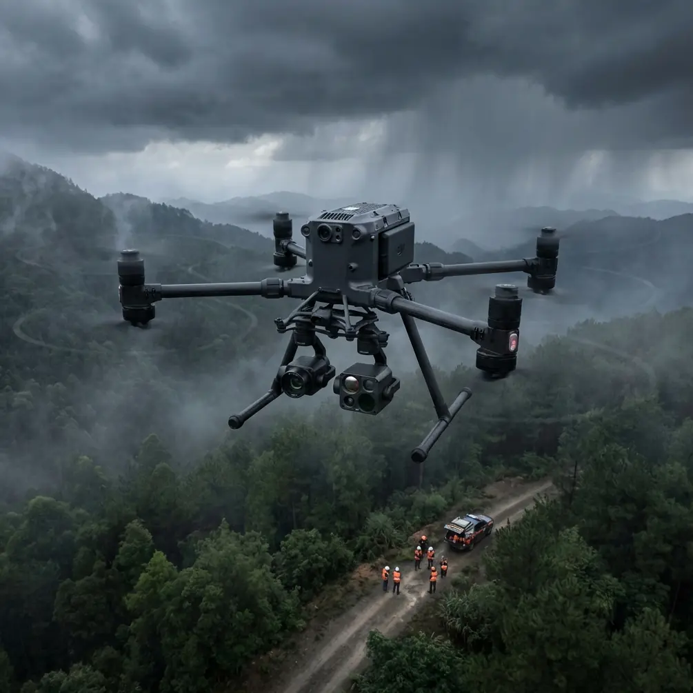
A beach survey close to a parking lot is one thing. A rugged coastal mission is another.
You may be documenting erosion over several tidal windows, building a photogrammetry model of a cliff face, checking revetments for settlement, inspecting outfalls with thermal signature differences, or mapping an inaccessible shoreline corridor for asset planning. In each case, the aircraft is only one piece of the job. Transmission stability, battery handling, payload coordination, data security, launch discipline, and sensor verification all become operational issues, not side notes.
That is where Matrice 400 can separate itself from lighter or more fragmented platforms. On paper, many drones promise strong camera performance. In the field, fewer of them stay composed when you are trying to capture consistent overlap in gusty marine air while also preserving link quality and managing battery swaps from a remote staging point.
The smartest way to use Matrice 400 on coastal capture missions
For coastline work, I would structure the Matrice 400 deployment around three linked outputs:
- Photogrammetry for measurable shoreline geometry
- Thermal passes for anomaly detection
- Repeatable inspection routes for future comparison
That sounds simple. It rarely is.
The photogrammetry side depends on disciplined overlap, stable altitude control, and good GCP strategy where ground access allows it. Coastlines often punish lazy control placement. If your checkpoints cluster only near the easy access path, the model may look sharp but drift where the cliff bends or where the beach narrows. The Matrice 400 becomes most useful when paired with a survey mindset: control where it counts, route planning that respects terrain variation, and enough transmission confidence to keep the mission clean rather than manually improvised.
Thermal adds another layer. Surface temperature on rock, concrete, wet sand, vegetation, and standing water changes rapidly with sun angle and tide. A thermal signature that looks meaningful at first glance may be environmental noise if capture timing is poor. The right approach is to use thermal as a comparative layer, not a magic detector. On Matrice 400, that means setting up repeatable acquisition conditions, noting tidal state, and revisiting suspect features with visual context rather than relying on one pass.
Then there is route repeatability. Coastline programs gain value over time. A single mission is useful. A repeatable route flown every month or every storm season becomes decision-grade. This is another reason the industry’s shift toward integration matters. It is not about flashy flights. It is about building a workflow that produces comparable datasets across dates, teams, and conditions.
Transmission discipline matters more on the coast than many crews expect
Remote coastal work is often sold as “wide open,” which leads people to assume communications will be easy.
Not always.
Cliff lines, headlands, reflective water surfaces, and abrupt terrain transitions can create awkward link behavior. This is where a robust transmission stack such as O3 transmission becomes operationally significant, not just a feature badge. If the aircraft maintains a cleaner control and video link as it moves along irregular coast geometry, the pilot can keep the mission on the planned grid instead of breaking formation and nursing the connection home.
That consistency directly improves data quality. Better route fidelity means cleaner overlap for photogrammetry, fewer missed sections, and less stitching trouble later. It also reduces the temptation to fly “just one more stretch” on a weak link, which is exactly the kind of decision that creates avoidable risk in remote zones.
For teams pursuing BVLOS frameworks where regulations and approvals permit, transmission reliability becomes even more consequential. BVLOS on a coastline is not simply about distance. It is about confidence in the whole operating envelope: route predictability, terrain awareness, weather windows, emergency options, and data continuity.
Coastal work punishes weak power management
This is one area where experienced crews quietly outperform everyone else.
Long shoreline corridors mean batteries are not just a flight-time matter. They determine whether you can preserve mission continuity. If you lose momentum during a carefully timed tide window, the whole day may be compromised. Hot-swap batteries are especially valuable here because they help keep the aircraft and payload workflow moving without forcing a complete operational reset between legs.
That matters when:
- the light is changing fast,
- the tide is turning,
- the client needs a continuous corridor,
- or the thermal conditions are only valid for a short period.
In practice, hot-swap capability reduces downtime and helps teams maintain a planned capture sequence. That can be the difference between a seamless coastal mosaic and a patchwork collected under different environmental states.
Competitor platforms often look acceptable until you calculate the real interruption cost of each battery cycle in a remote marine environment. Matrice 400’s advantage is not merely staying airborne. It is helping the operator protect the integrity of the mission timeline.
A lesson from manned aviation that drone teams should not ignore
One of the more useful reference points in the source material comes from traditional aircraft test procedure guidance. The manual excerpt states that once aircraft electrical and electronic equipment is installed, it should undergo function testing to prove it is in good condition. It also specifies strict controls during electrical interference testing: no other electrical or electronic work should be performed, the aircraft should be moved to an approved location, radio and audio noise should be minimized, and no engine should be operating within a 500-foot range during testing. It even notes that the responsible electrical engineering department should be notified at least 24 hours before the test.
On the surface, that sounds far removed from a Matrice 400 coastline mission. It is not.
The operational significance is huge. Drone teams often underinvest in interference and integration checks because the aircraft is smaller and the mission feels less formal than crewed aviation. That is a mistake. Coastal work already introduces enough uncertainty from weather, moisture, and terrain. You do not want hidden problems from hastily installed payloads, loose antennas, poor cable management, or unverified support gear.
For a Matrice 400 field program, the manned-aircraft lesson translates cleanly:
- Function-test the entire configured system after installation.
- Validate payload behavior before travel, not on the beach.
- Avoid noisy, cluttered staging zones for critical checks.
- Treat RF cleanliness as part of mission readiness.
This is especially relevant if you are combining visual capture, thermal sensors, and secure transmission workflows on the same aircraft. Integration failures rarely announce themselves in the shop. They appear when the drone is over inaccessible shoreline and the operator needs perfect predictability.
Why mechanical interfaces also matter in the drone workflow
The second technical reference may seem even less connected at first glance. It discusses standardized connection dimensions for aircraft hydraulic ground test equipment under ISO 3174, including how mating surfaces and tolerances are defined for reliable ground-interface use.
Again, the lesson is broader than the literal hardware.
Remote coastline work rewards systems built around repeatable interfaces. Standardized mating dimensions in aviation exist for one reason: reducing ambiguity when equipment connects under field conditions. For drone operators, the parallel is obvious. Batteries, chargers, antennas, payload mounts, storage cases, GCP kits, external power, and data offload tools all need predictable physical and procedural compatibility.
Why does that matter for Matrice 400?
Because remote marine jobs are punishing environments for ad hoc setups. If your support gear is improvised, small mismatches become delays. Delays become missed tide windows. Missed windows become return visits. A platform like Matrice 400 shows its value best when the whole field kit is organized around repeatable connections and repeatable routines.
The drone industry’s move toward integration is not abstract. It lives in these details.
A practical Matrice 400 coastline workflow
Here is the field structure I recommend.
1. Pre-mission integration check
Before deployment day, configure the aircraft exactly as it will fly. Verify payload mounting, media handling, battery health, transmission settings, and data security options such as AES-256 if the project requires controlled handling of sensitive infrastructure imagery.
Do not leave this for the launch point.
2. Establish control with the terrain in mind
If the mission is photogrammetry-driven, place GCP locations where they improve geometry, not only where access is easy. On coastlines, that often means balancing safe placement across elevation changes, hard edges, and elongated corridors.
3. Separate mapping logic from inspection logic
A clean mapping grid is not automatically a good inspection route. Use one mission profile for photogrammetry and another for targeted visual or thermal review. Matrice 400 is most effective when the operator stops trying to force one flight path to serve every purpose.
4. Capture thermal at the right moment
For thermal signature analysis, record environmental context. Surface moisture, solar loading, and tide state can completely change the meaning of a heat pattern. If you are checking for seepage, structural anomalies, or utility discharge, use thermal as a comparative diagnostic layer backed by visible imagery and repeat visits.
5. Use battery changes to preserve sequence integrity
With hot-swap batteries, plan your swaps around segment boundaries so the shoreline corridor remains logically divided and easy to reconstruct in post. Good segmentation saves time later.
6. Protect the link, not just the aircraft
When flying along cliffs or irregular coast edges, monitor how the environment affects O3 transmission performance. If link quality starts to degrade in a specific terrain pocket, adapt route direction or pilot position for the next leg rather than repeating a bad geometry.
7. Build repeatability into the deliverable
The best coastline datasets are not just visually impressive. They can be recreated months later with comparable conditions, route logic, and sensor setup. That is the standard serious clients increasingly expect.
Where Matrice 400 stands out against weaker alternatives
Many competing aircraft can do one piece of the job well enough.
Some are good for imagery but cumbersome for long corridor execution. Some handle inspection tasks but create too much downtime between flights. Some offer attractive sensor combinations but make transmission confidence feel conditional when terrain gets awkward.
Matrice 400’s edge in remote coastline work is not one isolated headline feature. It is the way the platform supports operational continuity. Stable transmission, secure data handling, practical battery strategy, and a workflow-friendly architecture matter more than novelty when you are several kilometers from the nearest easy recovery point.
That is the difference between a drone that demos well and a drone that earns trust on repetitive field assignments.
The human factor still decides the outcome
No aircraft, including the Matrice 400, fixes weak field discipline.
If your shoreline capture plan ignores changing tide lines, if your GCP layout is lazy, if your thermal timing is random, or if your payload test happens in the field with the client waiting, the mission quality will suffer. The best use of Matrice 400 is to treat it as a system platform that rewards preparation.
That lines up neatly with what AUVSI signaled at XPONENTIAL 2026. The industry is entering an integration phase. For coastal operators, that means the winning teams will not be the ones chasing novelty. They will be the ones who make aircraft, payloads, transmission, power, testing, and data outputs behave as one coherent field operation.
If you are planning a remote shoreline program and want to compare mission architecture, payload fit, or workflow setup for your site, you can message a Matrice 400 specialist here.
The coast is unforgiving. That is why integrated systems win there first.
Ready for your own Matrice 400? Contact our team for expert consultation.