Matrice 400 Field Report: Capturing Coastlines Where Wind
Matrice 400 Field Report: Capturing Coastlines Where Wind, Cliffs, and Signal Gaps Expose Weak Drone Systems
META: A field-style expert analysis of using Matrice 400 for coastline mapping, thermal inspection, and complex terrain capture, with practical insight on reliability, transmission, fail-safe design, and BVLOS-ready workflows.
By Dr. Lisa Wang, Specialist
Coastline work punishes weak assumptions.
On paper, many enterprise drones look capable enough for mapping beaches, cliffs, harbors, sea walls, and erosion zones. In the field, the equation changes fast. Salt haze softens contrast. Wind shifts around rock faces. GNSS geometry gets messy near bluffs and built waterfronts. Crews launch from cramped access roads, not ideal pads. And once the aircraft is out over water, the tolerance for interruption drops close to zero.
That is the lens through which the Matrice 400 becomes interesting.
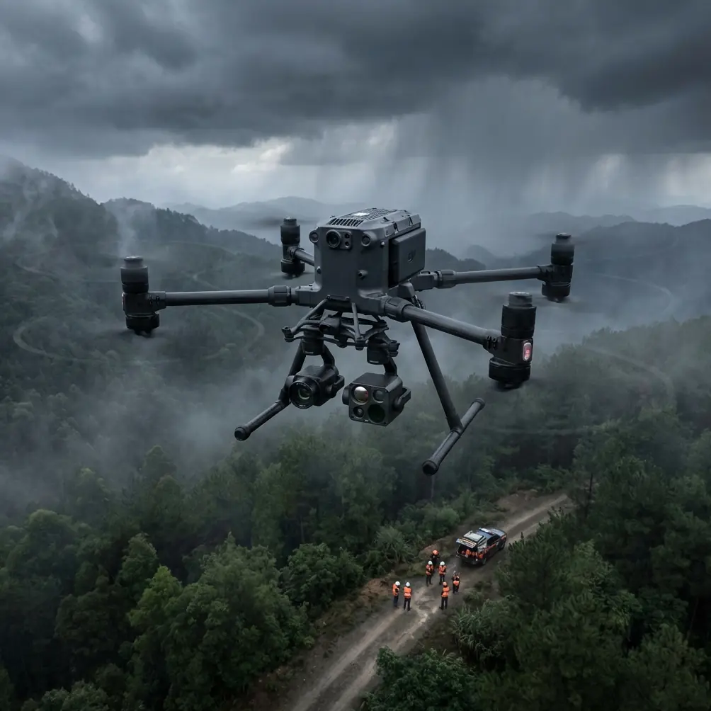
This is not a generic “bigger drone equals better results” story. The real value of a platform like the M400 in coastal operations is that it sits at the intersection of endurance, transmission resilience, payload flexibility, and fault-tolerant behavior. Those four factors matter more than brochure-level flight time claims when you are trying to complete a photogrammetry mission along an irregular shoreline or capture a thermal signature across breakwaters at dawn.
I want to focus on something readers often overlook: the best coastline drone is not just the one that flies farther. It is the one that continues to make good decisions when conditions stop being tidy.
Coastline capture is a systems problem, not a camera problem
A lot of operators start with sensor selection. That is understandable. Coastal projects may require visible-light orthomosaic work, thermal inspection of sea walls, habitat monitoring, sediment flow documentation, or 3D reconstruction of cliffs and embankments. Photogrammetry accuracy, lens matching, overlap planning, and GCP deployment all matter.
But on real sites, the aircraft system determines whether the sensor data will be usable at all.
Take a typical shoreline mission in complex terrain: a narrow launch area above a rocky descent, intermittent visual line of sight due to landforms, reflective water surfaces, and patchy cellular coverage if the team is coordinating with a ground observer. You may need to split the mission into multiple segments, maintain stable transmission across uneven terrain, and preserve enough reserve power for a safe return path that climbs back over the bluff.
This is where Matrice 400 stands apart from lighter or more consumer-oriented competitors. It is built for jobs where the aircraft has to remain predictable under operational stress, not just under ideal demo conditions.
Why the M400 makes sense for coastal photogrammetry
In coastline mapping, clean geometry beats flashy imagery.
You need stable, repeatable flight lines. You need consistent overlap. You need a platform that can hold track in shifting wind and still support enough payload options to adapt from RGB mapping to thermal survey without rebuilding the entire workflow. If you are establishing legal or engineering-grade records, you also need confidence in mission continuity. One dropped transmission event or one rushed battery swap can compromise a long linear survey.
The Matrice 400’s practical advantage here is less about one single spec and more about mission composure. Operators working along coastlines often compare it against smaller enterprise multirotors that are easier to carry but easier to disrupt. The smaller aircraft may be fine for short bluff-top inspections. The M400 begins to pull ahead when the mission extends into long corridor-style capture, mixed sensor use, and complex topography where airframe stability and transmission discipline make the difference between a complete dataset and a reshoot.
That matters financially, but it matters even more operationally. A coastal access permit, a vessel support window, or a low-tide inspection slot may not be easy to repeat.
Transmission is not a secondary feature on the coast
Many coastal flight failures are not really flight failures. They are communication failures that force conservative aborts.
Complex shorelines are hard on links. Cliffs block angles. Maritime structures create multipath behavior. Operators move between elevated and low ground. A drone may be visible to the naked eye and still have a compromised control or video path if the terrain geometry is working against it.
That is why O3 transmission-class performance is more than a convenience in this environment. Robust link management directly protects mission quality. On coastal jobs, strong transmission helps crews maintain framing discipline, confirm overlap health, and monitor hazards like low birds, masts, cranes, or transient marine activity near a structure. If you are flying a thermal payload to identify a heat anomaly in a harbor asset at first light, link confidence is what allows precise decision-making before the thermal contrast window closes.
Security also deserves a mention. For infrastructure and environmental programs, protected data paths are no longer optional. AES-256-level transmission security is not just an IT checkbox. It matters when imagery, thermal observations, or georeferenced infrastructure records are being collected for utilities, ports, engineering firms, or public agencies.
Fail-safe behavior matters more over water than over land
This is where the reference material becomes surprisingly relevant.
One of the supplied technical documents describes a fault-safe philosophy in aircraft steering control. In that example, a monitored circuit compares symmetric voltage points, and when one side drifts outside a defined high/low threshold window, the system triggers a protective response. The practical result is simple: if a fault appears, the system does not continue pretending everything is normal. It isolates the problem, signals it, and defaults into a safer state.
That logic should sound familiar to serious UAV operators, because it is exactly the mindset you want in a coastal aircraft platform.
The significance is not that the Matrice 400 literally copies a naval aircraft nose-wheel monitoring circuit. It is that good aviation design favors monitored thresholds, fault detection, and graceful degradation instead of blind persistence. Over coastlines, this philosophy is critical. If a payload feed becomes unreliable, if a battery pair begins to diverge, if a navigation input becomes questionable, the aircraft system should reveal the issue early and support a controlled decision rather than trap the crew in ambiguity.
The same source discusses a “window comparator” approach with upper and lower limits. Operationally, that matters because coastal drone work is full of variables that can drift rather than fail all at once: signal strength, wind margin, battery condition, and sensor confidence. On a strong platform, these are watched as bounded operational conditions, not as afterthoughts.
This is one reason large-frame enterprise aircraft remain the preferred choice for shoreline engineering and inspection teams. They are usually designed around monitored operating envelopes, not hobby-style tolerance.
Reliability is not a slogan; it is a validation method
The second technical reference is about civil aircraft reliability and maintainability. It is dry reading, but the implications for drone operations are real.
One detail from that document stands out: validation should be matched to the product and mission, including field-data statistical verification, leading-use verification, and weak-link validation. It also specifically notes that for civil aviation, reliability metrics should align with recognized standards, including dispatch reliability and event rates.
That framework is useful when evaluating the Matrice 400 for coastline work.
A serious coastal operation should not judge the aircraft only by flight time or payload capacity. It should ask harder questions:
- How often does the platform complete long linear missions without interruption?
- How often do battery changes create avoidable delays?
- Which component or workflow step is the weak link in salt-heavy, wind-heavy environments?
- What field data is being collected across repeated shoreline jobs to improve future dispatch reliability?
This is where hot-swap batteries become operationally significant. They reduce dead time between sorties, but the more meaningful advantage is continuity of workflow. On a narrow tidal inspection window, every minute lost to a full shutdown and restart sequence can cost usable light, water position, or thermal contrast. Hot-swapping is not merely convenient; it supports higher dispatch rhythm under field pressure.
Competitors often advertise compactness or simpler deployment. For straightforward inland jobs, that can be enough. Along coastlines, though, crews benefit more from an aircraft that behaves like a field system rather than a camera with rotors. The M400 is better understood in that category.
Thermal work on the coast rewards stable platforms
Thermal signature capture around coastlines is trickier than many newcomers expect.
Water behaves differently from rock, concrete, vegetation, and metal infrastructure. Morning and evening transitions can create short windows where seawalls, culverts, revetments, outfalls, and rooflines reveal meaningful thermal separation. Wind cools exposed surfaces unevenly. Moisture shifts surface response. A weak aircraft position hold or inconsistent gimbal behavior can turn a useful thermal pass into ambiguous data.
The Matrice 400’s advantage here is that it supports disciplined thermal collection in conditions where lighter platforms often show their limits sooner. For asset teams documenting seepage, void risk, drainage issues, or coastal facility performance, a stable flight platform increases the chance that a thermal anomaly is interpreted as a real condition rather than motion noise or angle inconsistency.
This is especially valuable when thermal and RGB datasets need to be cross-referenced later with photogrammetry outputs or engineering CAD layers.
GCP strategy still matters, even with a strong aircraft
No aircraft, not even a high-end one, eliminates the need for field discipline.
If you are using the Matrice 400 for coastal photogrammetry, GCP planning remains one of the biggest determinants of useful output. Complex terrain means you should think in elevation bands, not just horizontal spacing. A few well-placed control points on upper access paths, mid-slope safe locations, and lower reachable shoreline zones can dramatically improve model integrity, especially around cliffs or revetments where perspective changes quickly.
The better the aircraft holds its planned geometry, the more your GCP framework pays off. That is another quiet advantage of a robust platform. Accuracy is not created by the drone alone, but a stable and repeatable aircraft helps you preserve the value of every control point you set.
BVLOS thinking starts before regulation allows it
Many coastal corridors are natural candidates for BVLOS-style operational planning even when the actual mission remains within current local limits.
Why? Because the geography behaves like a corridor operation. The aircraft may move far along a shore, around a point, or beyond direct frontal visibility from the launch position. That means crews should already think in BVLOS terms: observer placement, terrain masking, return-path logic, battery reserve segmentation, communications redundancy, and abort points.
The Matrice 400 is well-suited to this style of planning because it supports enterprise workflows built around continuity and risk management. That does not mean teams should overextend. It means they can structure missions with professional margins instead of flying reactively.
If your team is designing a shoreline capture plan and wants a practical second opinion on payload matching, observer layout, or transmission considerations, it can help to message a coastal UAV workflow specialist here.
What the Lithuanian radar exercise tells us indirectly
The news reference about MatrixSpace in Lithuania may seem unrelated at first glance, but one point deserves attention: portable AI-powered radar was being used to improve low-altitude airspace awareness during a live exercise that ran from May 1 through May 15, 2026.
For civilian drone operators, the operational lesson is not about the military context. It is about low-altitude awareness becoming more data-driven and portable. Coastal environments often have layered low-altitude traffic conditions: birds, helicopters in some regions, utility activity, survey aircraft, and other drones near ports or infrastructure projects. As airspace awareness tools improve, enterprise drone missions will increasingly be planned as part of a broader sensing ecosystem rather than as isolated flights.
That is good news for Matrice 400-class operations. Larger enterprise platforms are the ones most likely to benefit from this shift because they are already used in structured inspection, mapping, and infrastructure programs where external situational-awareness data can be integrated into workflow planning.
The practical verdict
If your coastline work is occasional, short-range, and visually simple, you may not need the Matrice 400. A smaller system could be easier to move and quicker to launch.
But if your operations involve cliff faces, sea defenses, long linear mapping runs, thermal overlays, repeated sorties, or infrastructure-grade deliverables, the M400 earns its place. Not because it is flashy. Because it is built for missions that punish fragile workflows.
That distinction matters.
The strongest aircraft for coastal capture is not the one with the most dramatic headline feature. It is the one that handles signal complexity, fault monitoring, battery turnover, payload flexibility, and repeated field use with the least drama. The supplied aviation references reinforce that point from two angles: fail-safe monitoring through threshold-based fault detection, and reliability validation through field-proven metrics rather than assumptions. Those principles map directly onto why the Matrice 400 is a serious tool for shoreline operations.
When the landscape is uneven, the wind is variable, and your survey line runs above rocks on one side and open water on the other, “good enough” stops being good enough.
That is where the Matrice 400 starts to make sense.
Ready for your own Matrice 400? Contact our team for expert consultation.