Matrice 400 on a Harsh Coastline: A Field Report from Heat
Matrice 400 on a Harsh Coastline: A Field Report from Heat, Salt, Wind, and Wildlife
META: Specialist field report on using the Matrice 400 for coastline capture in extreme temperatures, with practical insight on thermal signature work, photogrammetry, O3 transmission, hot-swap batteries, and BVLOS planning.
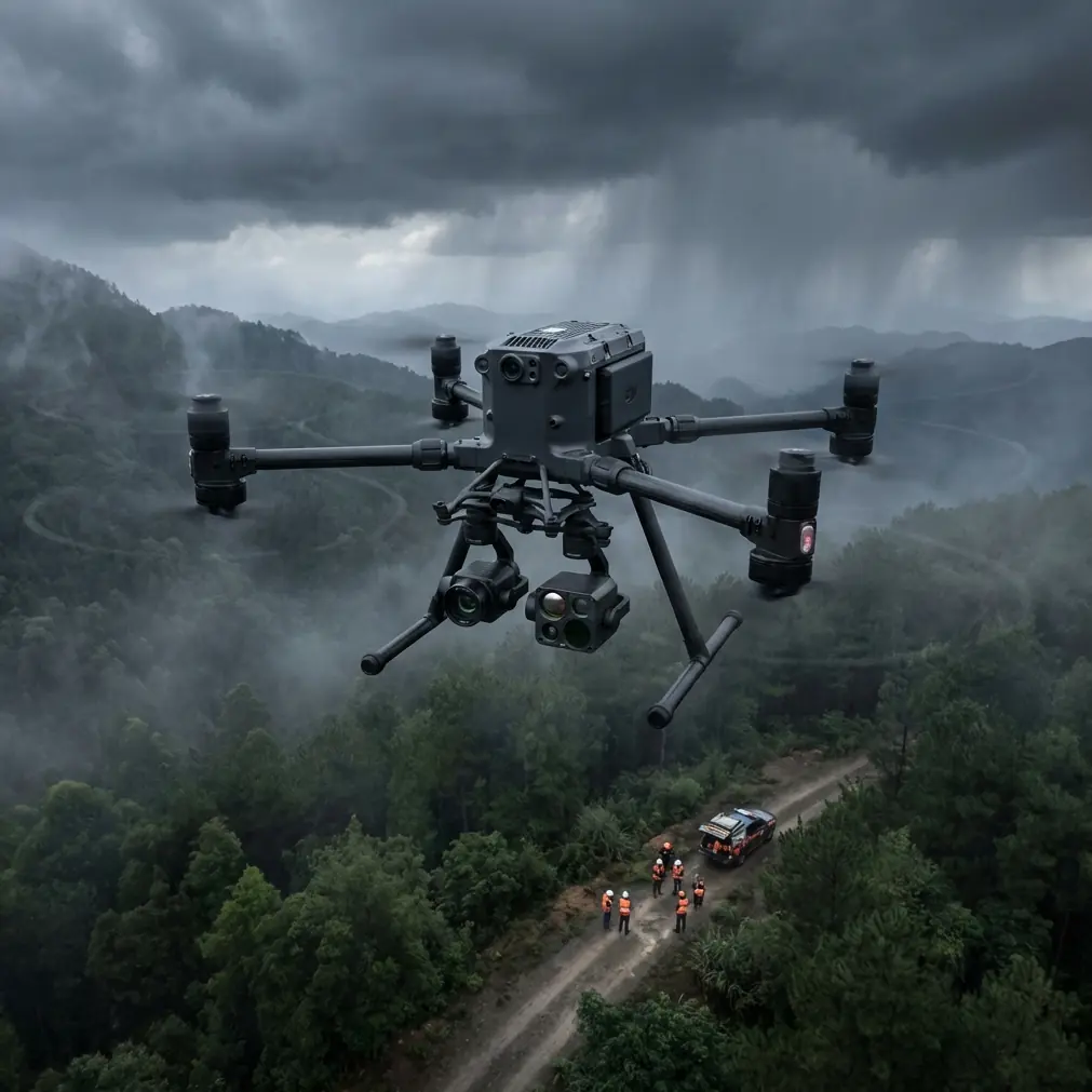
I took the Matrice 400 to the coast for the kind of job that looks simple on a briefing slide and turns complicated the moment salt haze hits the lenses. The assignment was straightforward on paper: document an exposed shoreline corridor, collect photogrammetry data for erosion analysis, inspect rock armor and sea wall segments, and capture thermal signature anomalies around drainage outfalls before sunrise and again after the ground heated up.
The reality was a rolling mix of wind shear, reflective water, abrupt temperature changes, and wildlife moving through the survey box exactly when we needed stable passes.
This is a field report, not a brochure. And if you are evaluating the Matrice 400 for coastline work in extreme temperatures, that distinction matters.
Why coastlines punish weak workflow design
Coastal missions stack several flight challenges on top of one another. You get unstable air over rock faces and warm pavement, moisture in the atmosphere that softens contrast, bright specular reflections off water, and surfaces that change their thermal behavior by the hour. Even a well-planned photogrammetry mission can drift off target if your transmission link, battery swap rhythm, or control response is not dialed in.
That is where the Matrice 400 platform starts to separate itself. Not because it magically removes the environment, but because it gives you a better margin for dealing with it.
For our mission, the real priority was continuity. We needed clean overlap for mapping, repeatable orbit positions for structure inspection, and dependable situational awareness during longer corridor legs where BVLOS planning principles shaped the route design. In a coastal setting, losing even a small slice of consistency can ruin an otherwise expensive survey day.
The moment wildlife changed the plan
On the second morning sortie, just after first light, we were running a low-angle thermal pass near a tidal cut when a group of shorebirds lifted from the rocks ahead of the flight path. A few seconds later, a larger bird broke from the bluff face and crossed left to right over the surf line.
This is where sensor awareness matters more than flight bravado.
We paused the run, widened separation, and adjusted the route to hold the mission geometry without pushing through the wildlife activity zone. The Matrice 400’s sensing and observation capability let us spot the movement early enough to avoid compressing our choices into a last-second stick input. That is a practical difference. On paper, obstacle awareness sounds like a safety feature. In the field, it becomes a data-protection feature too, because rushed evasive movement is how you corrupt image alignment, break thermal consistency, or miss a critical inspection angle.
The wildlife encounter also reinforced a rule I teach to new operators: on coastline jobs, the mission is never only about terrain. Birds, spray, glare, and airflow are active participants.
Extreme temperature work is really a systems discipline
People often reduce extreme-weather drone work to battery performance. Batteries do matter, especially when you are moving between cool dawn air and heat-radiating rock later in the day, but the bigger issue is system stability across changing conditions.
The Matrice 400 is valuable here because it supports a more disciplined operational cadence. Hot-swap batteries are not a luxury on this kind of mission. They preserve momentum. On our site, the survey box was long enough that every reset introduced risk: wind changed, light changed, and water texture changed. With hot-swap workflow, the crew could keep the aircraft ready while preserving mission continuity and reducing dead time on the bluff edge staging area.
That continuity matters for thermal work even more than for RGB mapping. If you are tracking thermal signature differences around drainage discharge points or infrastructure seams, the environment is already altering your scene minute by minute. Long interruptions make comparison less reliable. A platform that helps you stay in rhythm gives you cleaner interpretation later.
Photogrammetry over coastlines: the hard part is not flying straight
Coastal photogrammetry often fails in two places: poor surface definition over repetitive textures, and inconsistency at land-water transitions. Sand, rock, concrete revetment, vegetation, foam, and wet surfaces all behave differently in image reconstruction.
With the Matrice 400, the biggest advantage for this type of job is not one single specification. It is the ability to maintain repeatable, controlled acquisition under conditions that tempt operators to improvise. O3 transmission stability is part of that equation. Along this shoreline, we had sections where bluff geometry and infrastructure created awkward signal environments. Maintaining confident link performance is not about operator comfort; it directly affects whether you can hold mission discipline on long corridor captures.
We ran the mapping mission with carefully placed GCPs on stable surfaces above the splash zone. That reduced ambiguity in areas where natural texture alone would not be enough for high-confidence reconstruction. If you work these environments regularly, you already know the trap: a beautiful-looking orthomosaic can still hide weak geometry if control strategy is lazy. The Matrice 400 can carry the mission load, but your output quality still depends on disciplined ground control and sensible overlap planning.
A useful lesson from old aircraft design logic
One detail from classical aircraft design is surprisingly relevant to a modern UAV operator in rough coastal air: small control inputs can often be treated as linear, but once conditions shift, the relationship between control movement and aerodynamic response is no longer something you should take for granted.
In the reference material from 飞机设计手册 第6册 气动设计, page 830, the elevator hinge moment is described with a general expression and then linearized for small-angle operation. The text explicitly notes that the hinge-moment coefficient can be nonlinear, but within a small angle range it may be approximated in a linear form. It also points out that if stick displacement and elevator deflection are nonlinear, the transmission ratio should be taken from the local relationship rather than assumed constant.
Why bring that into a Matrice 400 field report?
Because it is the same operating mindset you need on a windy coastline. In smooth air, a platform may feel predictable enough that pilots get casual with inputs. Over cliffs, surf, and heated rock, that predictability narrows. You should think in terms of response regime, not just control habit. The operational significance is simple: keep corrections measured, anticipate transient airflow, and avoid forcing the aircraft into repeated aggressive input cycles that can degrade image quality and increase energy consumption.
That old aerodynamic principle is not academic decoration. It is a reminder that stable data collection begins with respecting how control response changes with the environment.
Why structural thinking also belongs in a drone mission plan
The second reference, from 飞机设计手册 第9册 载荷、强度和刚度, pages 502 to 503, outlines three instability modes in a stiffened cylindrical shell: skin instability, panel instability between frames, and overall instability when frame stiffness is insufficient to force nodal behavior. In the source, this appears in the discussion of semi-monocoque structure, where the skin, longitudinal stiffeners, and transverse frames work together.
That has direct relevance to coastal drone operations, just not in the obvious way.
When you inspect sea walls, light towers, tanks, culverts, or coastal utility assets with the Matrice 400, you are often looking at structures where local damage and global behavior are different problems. A thermal anomaly or visible surface ripple may point to a local issue, but not necessarily a system-level one. Conversely, a structure can present minor local blemishes while hiding a broader stiffness or load-path concern. The operational significance of this reference is that data capture should be designed to distinguish local panel-like defects from whole-structure deformation patterns.
In practice, that means you do not just collect pretty obliques. You plan for coverage that lets engineers interpret whether they are seeing isolated surface distress or signs of larger instability. On our coastline mission, that changed how we flew around a curved retaining segment. We added wider contextual passes beyond the close inspection set because local imagery alone would not support a reliable reading of the overall geometry.
This is exactly where the Matrice 400 earns its keep: it can support both near-detail inspection logic and broader mapping logic in the same operational window.
Transmission and security matter more near critical coastal assets
Many shoreline projects overlap with ports, utilities, flood-control systems, environmental monitoring zones, or transport infrastructure. That means the discussion cannot stop at image quality. Data handling matters.
For teams working near sensitive civilian infrastructure, AES-256 is not just a checkbox feature. It helps align the flight operation with the security expectations that increasingly surround industrial surveys. Pair that with dependable O3 transmission, and you get a workflow that is not only more stable in the air, but also easier to justify to stakeholders who care about data integrity from capture through handoff.
That tends to become a bigger issue on BVLOS-oriented planning or extended corridor work, where the communication chain is part of the risk equation from the start.
Thermal signature work: the coastline lies to you unless you time it right
Thermal imaging on coastlines produces useful results, but only if you respect how quickly the scene changes. Wet rock can mask what dry concrete reveals. Buried moisture can become visible only after a differential heating period. Outfalls can look dramatic at one hour and almost disappear at another.
The Matrice 400 gives you the endurance and operational continuity to exploit those windows. On our mission, dawn thermal runs highlighted a subtle discharge pattern near a reinforced drainage point that became far less distinct once the adjacent rock face absorbed heat. Later, the warmer conditions helped reveal a separate seam behavior on infrastructure above the tide line. Two flights, same general area, different interpretation value.
This is why I never treat thermal as a one-pass add-on to RGB capture. If the mission goal includes thermal signature analysis, schedule around thermal physics, not pilot convenience.
Practical notes from the field
A few field-tested observations stood out on this deployment:
First, coastline missions reward crews that think in layers. We used primary mapping legs, secondary inspection orbits, and contingency reroutes for wildlife and wind shifts. The aircraft handled the mission flow better because the crew had already accepted that one flight plan would not survive first contact with the site unchanged.
Second, GCP placement still matters even with strong onboard systems. On irregular shoreline terrain, control points are the difference between a visually appealing model and one that supports measurement confidence.
Third, battery strategy is part of data strategy. Hot-swap capability helped us keep timing tight during thermal windows and avoid rebuilding the mission state from scratch after every interruption.
Fourth, transmission quality affects pilot behavior. A stable O3 link reduces the subtle tendency to overcorrect or abandon a disciplined line just because situational confidence dips for a moment.
If you are building out a real-world coastline workflow around the Matrice 400 and want to compare field setups, sensor combinations, or mission planning logic, you can message our flight team here.
Is the Matrice 400 a serious coastline tool?
Yes, but only in the hands of operators who understand what the coastline is asking from the aircraft.
This platform makes sense when the job requires more than basic aerial imaging. It is especially effective when you need to combine photogrammetry, thermal signature assessment, repeatable inspection geometry, secure data handling, and an operational tempo that can survive harsh temperatures and shifting conditions. The value is not just that it flies. Plenty of drones fly. The value is that it supports disciplined capture when the environment is trying to break your consistency.
The older aircraft-design references behind this discussion may seem far removed from a modern UAV, but they point to the same truth. Control response is not always linear in the real world, and structural interpretation requires more than surface-level observation. Those ideas matter on a coastline where turbulence, salt, and complex infrastructure make lazy assumptions expensive.
The Matrice 400 does not make the coast easier. It makes difficult coastal work more manageable, more repeatable, and more defensible when the results have to stand up to engineering review.
Ready for your own Matrice 400? Contact our team for expert consultation.