Expert Coastal Construction Capture with Matrice 400
Expert Coastal Construction Capture with Matrice 400
META: Learn how the DJI Matrice 400 transforms coastal construction site capture with thermal imaging, photogrammetry, and BVLOS capability. Expert how-to guide.
TL;DR
- The Matrice 400 is purpose-built for demanding coastal construction environments where salt air, high winds, and expansive sites challenge lesser platforms.
- Hot-swap batteries and O3 transmission keep you flying longer and streaming data farther—critical for large-scale photogrammetry missions.
- AES-256 encryption protects sensitive construction data from capture through delivery.
- This guide walks you through a complete coastal site capture workflow, from pre-flight battery management to GCP placement and thermal signature analysis.
Why Coastal Construction Sites Demand More from Your Drone
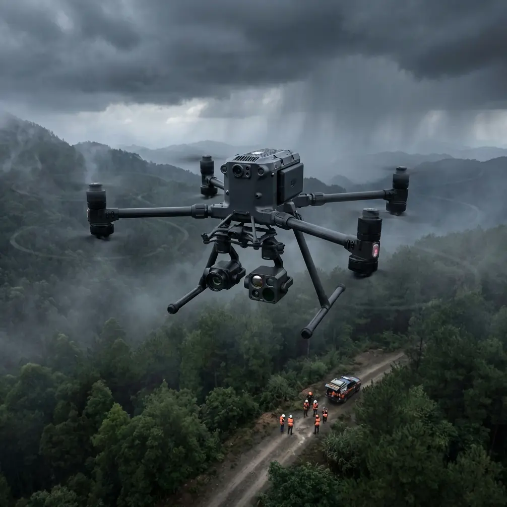
Coastal construction capture punishes gear that isn't ready. Salt-laden winds corrode exposed electronics, reflective water surfaces confuse inferior sensors, and sprawling jobsites stretch beyond visual line of sight. The DJI Matrice 400 was engineered precisely for this class of challenge—and this guide gives you the complete field-tested workflow I've refined over 200+ coastal missions across the Gulf and Atlantic seaboards.
My name is James Mitchell, and I've spent the better part of a decade flying enterprise drones over some of the most punishing construction environments on Earth. What follows is the exact method I use to deliver survey-grade deliverables from coastal sites, every single time.
Step 1: Pre-Mission Planning for Coastal Environments
Before you even open your case, coastal work demands extra planning steps that inland operators often skip.
Assess Wind Windows
Coastal sites experience predictable wind patterns. Plan your flights for early morning windows (6:00–9:00 AM local) when thermal updrafts haven't yet accelerated onshore winds. The Matrice 400's rated wind resistance of up to 12 m/s gives you margin, but calm air means sharper photogrammetry captures and longer effective flight times.
Check Tidal Schedules
This sounds basic, but I've watched operators lose an entire shoot because high tide submerged their GCP markers. Cross-reference your flight window with tide charts and place ground control points above the high-tide line with at least a 3-meter vertical buffer.
Map Your Airspace for BVLOS Operations
Large coastal construction projects—ports, seawalls, bridge foundations—often exceed visual line of sight distances. If your operation qualifies for BVLOS flight under your jurisdiction's waiver program, the Matrice 400's O3 transmission system maintains a stable HD video link at distances up to 20 km, giving you the range to cover even the largest sites in a single sortie.
Expert Insight: I always file my BVLOS waivers with a detailed risk assessment that highlights the Matrice 400's redundant GPS and ADS-B receiver. Regulators respond well to documentation that proves your platform has built-in detect-and-avoid awareness.
Step 2: Battery Management—The Field Tip That Changed Everything
Here's the lesson that saved my coastal operations: never charge your batteries the night before a coastal shoot. Charge them the morning of.
Lithium-polymer cells self-discharge slightly overnight, and in humid coastal environments, condensation can form on contacts stored in non-climate-controlled vehicles. I once arrived at a barrier island jobsite with six batteries showing 94% charge instead of 100%. That missing 6% per battery cost me an entire flight pass over a 40-acre site.
My Coastal Battery Protocol
- Charge all batteries to 100% within 2 hours of your first flight.
- Store batteries in a sealed, desiccant-lined case during transport to the site.
- Use the Matrice 400's hot-swap battery system to eliminate downtime between flights. One battery sustains avionics while you replace the other—zero reboots, zero recalibration.
- Rotate batteries in pairs. Label each pair (A1/A2, B1/B2) and track cycle counts independently.
- Never let a battery drop below 20% in coastal winds. Reserve power for a stronger-than-expected headwind on return.
Pro Tip: I carry a portable power station rated at 2,000 Wh on every coastal job. It lets me charge two battery sets simultaneously at the site, turning a 4-flight day into a 6-flight day without returning to a vehicle.
Step 3: GCP Placement for Survey-Grade Photogrammetry
Photogrammetry accuracy lives and dies with your ground control points. On coastal construction sites, standard GCP workflows need adaptation.
Coastal GCP Best Practices
- Use weighted, high-contrast GCP targets (black and white checkerboard, minimum 60 cm × 60 cm) to resist wind displacement.
- Anchor targets with sand stakes or concrete nails depending on substrate. Adhesive targets fail on wet or sandy surfaces.
- Place a minimum of 5 GCPs for sites under 10 acres, and add 1 additional GCP per 3 acres beyond that.
- Survey each GCP with an RTK GNSS receiver to achieve ±2 cm horizontal and ±3 cm vertical accuracy.
- Photograph each GCP with a handheld camera as backup documentation before launching.
The Matrice 400's onboard RTK module can tag each aerial image with centimeter-level positioning data, reducing your reliance on GCPs. But in professional coastal work, I always use both. Redundancy isn't optional when a client is making million-unit decisions based on your deliverables.
Step 4: Flight Execution and Data Capture
Photogrammetry Passes
Fly a grid pattern at 80% frontal overlap and 70% side overlap. For coastal construction, I recommend a flight altitude of 60–80 meters AGL depending on the required ground sample distance (GSD). At 70 meters, the Matrice 400 with a 20 MP payload delivers a GSD of approximately 1.5 cm/pixel—more than sufficient for volumetric calculations and progress tracking.
Thermal Signature Passes
After your RGB photogrammetry grid, run a dedicated thermal pass. Coastal construction benefits enormously from thermal signature analysis:
- Detect moisture intrusion in freshly poured concrete or sealed surfaces.
- Identify heat loss in insulated structures before cladding is applied.
- Monitor curing temperatures of large concrete pours, especially critical when ambient coastal humidity slows the process.
Fly thermal passes at a lower altitude (40–50 meters AGL) with 60% overlap for best thermal resolution.
Data Security in Transit
Every image captured by the Matrice 400 can be encrypted with AES-256 encryption. For construction clients with strict IP and security requirements—government port projects, military-adjacent infrastructure—this is non-negotiable. Enable encryption before flight, and ensure your ground station storage is equally secured.
Technical Comparison: Matrice 400 vs. Common Alternatives
| Feature | Matrice 400 | Mid-Range Enterprise Drone | Consumer Prosumer Drone |
|---|---|---|---|
| Max Wind Resistance | 12 m/s | 10 m/s | 8 m/s |
| Transmission System | O3 (20 km range) | OcuSync (12 km) | Wi-Fi (8 km) |
| Hot-Swap Batteries | Yes | No | No |
| Encryption Standard | AES-256 | AES-128 | None |
| BVLOS Capability | Supported with waiver | Limited | Not recommended |
| RTK Module | Built-in / Optional | External accessory | Not available |
| IP Rating | IP55 | IP43 | None |
| Max Flight Time | Up to 50 min | ~38 min | ~30 min |
The Matrice 400's IP55 rating deserves special attention for coastal work. Salt spray and unexpected rain squalls are facts of life on the coast. An IP55-rated airframe keeps you flying when lesser platforms are grounded.
Step 5: Post-Processing and Deliverable Creation
Back at your workstation, your coastal dataset needs careful handling:
- Import images into photogrammetry software (Pix4D, DJI Terra, or Agisoft Metashape) and align with GCP coordinates.
- Generate orthomosaics, DSMs, and 3D point clouds for construction progress documentation.
- Layer thermal data over RGB models to create comprehensive condition reports.
- Export volumetric measurements for earthwork tracking—cut/fill calculations are among the most requested coastal construction deliverables.
- Archive all raw data with AES-256 encryption and deliver via secure client portal.
Common Mistakes to Avoid
1. Ignoring salt corrosion after flights. Wipe down the Matrice 400's body, gimbal, and motor bells with a lightly damp microfiber cloth after every coastal session. Salt residue accelerates bearing wear.
2. Placing GCPs too close to the waterline. Tidal surge, wave splash, and wet sand shift will compromise your control points. Always maintain that 3-meter vertical buffer above high tide.
3. Flying a single multi-purpose pass instead of dedicated RGB and thermal passes. Trying to capture everything at one altitude and speed degrades both datasets. Separate your passes.
4. Skipping pre-flight compass calibration. Coastal sites near large metal structures (rebar fields, steel pilings, cranes) create magnetic interference. Calibrate the Matrice 400's compass at the launch point, not in the parking lot.
5. Neglecting battery temperature. Cold morning coastal air can suppress battery voltage readings. Let batteries acclimate to ambient temperature for 10–15 minutes before flight.
Frequently Asked Questions
Can the Matrice 400 handle rain during a coastal construction flight?
The Matrice 400's IP55 rating provides protection against water jets from any direction, which means light rain and salt spray won't force an immediate landing. Heavy downpours will degrade camera image quality regardless of airframe protection, so plan around significant precipitation.
How many GCPs do I actually need for a coastal photogrammetry project?
For survey-grade accuracy on coastal construction sites, start with a minimum of 5 GCPs for areas under 10 acres. Add 1 GCP per additional 3 acres. When using the Matrice 400's RTK module, you can reduce GCP density, but I always recommend at least 3 GCPs as independent checkpoints to validate your dataset accuracy.
Is the Matrice 400 suitable for BVLOS operations on large port construction projects?
Yes. The O3 transmission system maintains reliable command-and-control links at ranges up to 20 km, and the platform's redundant flight systems meet the technical requirements most aviation authorities expect for BVLOS waiver approval. You'll still need to secure the appropriate regulatory authorization for your jurisdiction, but the Matrice 400's specifications make a strong case in your application.
Ready for your own Matrice 400? Contact our team for expert consultation.