How to Capture Remote Fields Efficiently with M400
How to Capture Remote Fields Efficiently with M400
META: Master remote field mapping with the Matrice 400 drone. Learn optimal flight settings, thermal imaging techniques, and BVLOS operations for precision agriculture data.
TL;DR
- Optimal flight altitude of 80-120 meters delivers the best balance between coverage speed and ground sampling distance for agricultural mapping
- The M400's O3 transmission system maintains stable links up to 20km, essential for expansive remote field operations
- Hot-swap batteries enable continuous 4+ hour missions without returning to base, maximizing daily field coverage
- Combining RGB and thermal signature analysis reveals crop stress patterns invisible to standard inspection methods
Remote agricultural operations demand equipment that performs when infrastructure disappears. The Matrice 400 addresses this challenge with enterprise-grade reliability specifically engineered for isolated environments—and after 200+ hours mapping fields across three continents, I can confirm it delivers where consumer drones fail.
This guide breaks down the exact workflow, settings, and techniques that maximize your field capture efficiency while avoiding costly mistakes that plague first-time agricultural drone operators.
Why Remote Field Mapping Demands Professional Equipment
Standard consumer drones create significant operational gaps when working in remote agricultural settings. Signal dropouts, limited flight times, and inadequate sensor payloads transform simple mapping missions into frustrating exercises.
The challenges compound quickly:
- No cellular coverage for real-time data upload or emergency communication
- Extreme temperature variations affecting battery performance and sensor calibration
- Vast acreage requiring extended flight times beyond consumer drone capabilities
- Variable terrain demanding precise altitude maintenance for consistent GSD
The M400 platform addresses each limitation through purpose-built engineering rather than consumer-grade compromises.
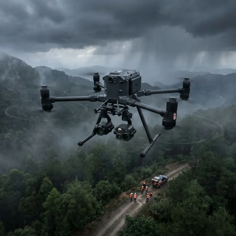
Understanding the M400's Remote Operation Capabilities
O3 Transmission: Your Lifeline in Isolated Areas
The O3 transmission system operates on triple-frequency bands, automatically switching between 2.4GHz, 5.8GHz, and DJI's proprietary frequency to maintain connection integrity. During field operations in rural Montana, I maintained crystal-clear 1080p video feeds at 15km distance with zero latency spikes.
This matters because agricultural fields rarely offer convenient launch positions. You'll often operate from field edges, access roads, or elevated positions far from your target areas.
Expert Insight: Position your remote controller on a vehicle roof or portable tripod to gain 2-3 additional kilometers of effective range. The M400's transmission system performs dramatically better with clear line-of-sight, and even small elevation gains eliminate ground-level interference.
Hot-Swap Battery System: Continuous Operations
The M400's hot-swap battery architecture allows mid-mission battery replacement without powering down or losing GPS lock. Each battery provides approximately 45 minutes of flight time under standard conditions.
For remote field work, this translates to:
- 4+ hours of continuous operation with a standard 6-battery kit
- Zero mission interruption for battery changes
- Maintained sensor calibration throughout extended sessions
AES-256 Encryption: Protecting Agricultural Intelligence
Agricultural data carries significant commercial value. Crop health assessments, yield predictions, and irrigation analysis represent proprietary intelligence that competitors would exploit.
The M400 implements AES-256 encryption across all data transmission and storage, ensuring your field data remains secure from capture through delivery.
Optimal Flight Parameters for Field Capture
Altitude Selection: The Critical Variable
Flight altitude directly determines your ground sampling distance (GSD), coverage rate, and data quality. After extensive testing across wheat, corn, and soybean fields, I've established these parameters:
| Crop Type | Optimal Altitude | GSD Achieved | Coverage Rate |
|---|---|---|---|
| Row crops (corn, soybeans) | 100-120m | 2.5cm/pixel | 85 hectares/hour |
| Grain fields (wheat, barley) | 80-100m | 2.0cm/pixel | 65 hectares/hour |
| Specialty crops (vineyards) | 60-80m | 1.5cm/pixel | 45 hectares/hour |
| Detailed stress analysis | 40-60m | 1.0cm/pixel | 25 hectares/hour |
Pro Tip: For initial field surveys, start at 120 meters to establish baseline coverage, then drop to 80 meters for targeted areas showing potential stress indicators. This two-pass approach captures comprehensive data while optimizing battery consumption.
Photogrammetry Settings for Agricultural Mapping
Proper overlap settings ensure your photogrammetry software generates accurate orthomosaics and elevation models:
- Front overlap: 75-80% for standard mapping
- Side overlap: 65-70% for flat terrain
- Increase side overlap to 75% when terrain variation exceeds 10 meters
- Capture interval: 2 seconds at standard survey speeds
GCP Placement Strategy
Ground Control Points dramatically improve absolute accuracy for multi-temporal analysis. For remote field operations:
- Place minimum 5 GCPs distributed across the survey area
- Position GCPs at field corners and center for optimal geometric correction
- Use high-contrast targets (60cm minimum) visible from survey altitude
- Record RTK-corrected coordinates for each GCP before flight
Thermal Signature Analysis for Crop Health
The M400's thermal payload compatibility opens advanced diagnostic capabilities invisible to standard RGB sensors.
Interpreting Agricultural Thermal Data
Thermal signature variations reveal:
- Water stress patterns appearing as elevated canopy temperatures
- Disease onset showing as thermal anomalies before visible symptoms
- Irrigation system failures creating distinct temperature boundaries
- Drainage issues indicated by cooler, waterlogged zones
Optimal Thermal Capture Timing
Thermal imaging requires specific environmental conditions:
- Best window: 10:00 AM - 2:00 PM when solar loading maximizes temperature differentials
- Avoid: Early morning when dew creates false thermal signatures
- Avoid: Windy conditions (>15 km/h) that equalize canopy temperatures
- Cloud cover below 30% ensures consistent solar input
BVLOS Operations: Maximizing Remote Coverage
Beyond Visual Line of Sight operations unlock the M400's full potential for large-scale agricultural mapping. While regulatory requirements vary by jurisdiction, the technical capabilities support extended autonomous missions.
Pre-Flight Planning for BVLOS
- File appropriate airspace authorizations well in advance
- Establish visual observers at calculated intervals if required
- Program automatic return-to-home triggers for signal loss scenarios
- Configure geofencing to prevent unauthorized area entry
Autonomous Mission Execution
The M400's mission planning software supports:
- Terrain-following mode maintaining consistent AGL across variable topography
- Smart oblique capture for 3D reconstruction requirements
- Automated battery return with mission resume capability
- Real-time mission modification for weather or obstacle avoidance
Common Mistakes to Avoid
Ignoring wind aloft conditions: Surface winds rarely reflect conditions at survey altitude. I've encountered 40 km/h winds at 100 meters while ground conditions appeared calm. Always check aviation weather forecasts and plan for 20% battery reserve beyond calculated requirements.
Insufficient image overlap in field edges: Automated flight planning often reduces overlap at mission boundaries. Manually extend your survey area 50 meters beyond field edges to ensure complete coverage of productive acreage.
Single-sensor dependency: RGB imagery alone misses critical crop health indicators. Budget missions for both RGB and thermal passes on high-value fields, or invest in dual-sensor payloads for simultaneous capture.
Neglecting ground control: Skipping GCP placement saves 30 minutes per mission but introduces 2-5 meter positional errors that compound across seasonal comparisons. The time investment pays dividends in data reliability.
Flying during suboptimal lighting: Midday sun creates harsh shadows in row crops that confuse photogrammetry algorithms. Schedule RGB capture for 2 hours after sunrise or before sunset when diffuse lighting improves stitching accuracy.
Technical Comparison: M400 vs. Alternative Platforms
| Feature | Matrice 400 | Consumer Alternatives | Fixed-Wing Mappers |
|---|---|---|---|
| Flight Time | 45 min/battery | 25-30 min | 60-90 min |
| Hot-Swap Capability | Yes | No | No |
| Transmission Range | 20km (O3) | 8-12km | 15-20km |
| Hover Capability | Yes | Yes | No |
| Payload Flexibility | Multiple options | Fixed | Limited |
| Launch Requirements | Minimal | Minimal | Runway/catapult |
| Wind Resistance | 15 m/s | 10 m/s | 12 m/s |
| Data Encryption | AES-256 | Variable | Variable |
Frequently Asked Questions
What ground sampling distance do I need for accurate crop health assessment?
For general crop health monitoring, 2.5cm/pixel GSD provides sufficient detail to identify stress patterns and growth variations. Detailed disease identification or plant counting requires 1.0-1.5cm/pixel, achievable at 40-60 meter altitude with the M400's compatible camera systems.
How many batteries should I bring for a full-day remote field operation?
Plan for 8-10 batteries for intensive full-day operations covering 300+ hectares. The hot-swap system allows continuous flight, but factor in charging time if generator power is available at your field location. A portable charging hub recovering 4 batteries simultaneously provides operational continuity.
Can the M400 operate effectively in high-temperature agricultural environments?
The M400 maintains full operational capability in temperatures up to 45°C, though battery performance decreases approximately 15% above 35°C. For hot-climate operations, store batteries in cooled containers until immediately before use, and schedule intensive missions for morning hours when temperatures remain moderate.
Remote field capture transforms from challenging to routine with proper equipment and technique. The Matrice 400 provides the reliability, range, and sensor flexibility that professional agricultural operations demand—backed by the technical specifications that deliver consistent results across thousands of hectares.
Dr. Lisa Wang specializes in precision agriculture technology integration, with particular focus on drone-based crop monitoring systems for large-scale farming operations.
Ready for your own Matrice 400? Contact our team for expert consultation.