Matrice 400 Field Report: Capturing Urban Fields Without
Matrice 400 Field Report: Capturing Urban Fields Without Losing Data, Signal, or Time
META: A specialist field report on using the Matrice 400 for urban field capture, covering thermal signature control, photogrammetry workflow, GCP strategy, O3 transmission, AES-256 security, hot-swap batteries, and BVLOS planning.
Urban field capture sounds simple until you actually step onto the site.
You are not flying over an open rural block with clean sightlines and predictable lighting. You are usually dealing with fenced parcels, half-developed lots, utility poles, reflective roofs, moving vehicles, patchy GNSS conditions, and the kind of radio interference that turns a comfortable mapping job into a technical exercise. That is exactly where the Matrice 400 becomes interesting—not as a spec-sheet trophy, but as a working aircraft for crews who need repeatable results in messy environments.
I have been asked a version of the same question many times: if the task is “capturing fields in urban,” what really matters on the Matrice 400 platform? Not the marketing language. Not the broad promise of “better efficiency.” The answer is workflow resilience. In urban conditions, resilience means maintaining link stability, preserving positional accuracy, managing thermal behavior, and keeping the mission moving when battery swaps and airspace constraints are unavoidable.
That is the frame for this field report.
Why urban field capture is harder than most teams expect
A city-edge field or an urban infill parcel creates a strange blend of agricultural-style mapping requirements and metropolitan flight challenges. The customer may want orthomosaics, volumetric change checks, drainage analysis, heat-loss clues around bordering structures, or progress documentation before development. On paper, those are straightforward deliverables. In practice, the site environment drives everything.
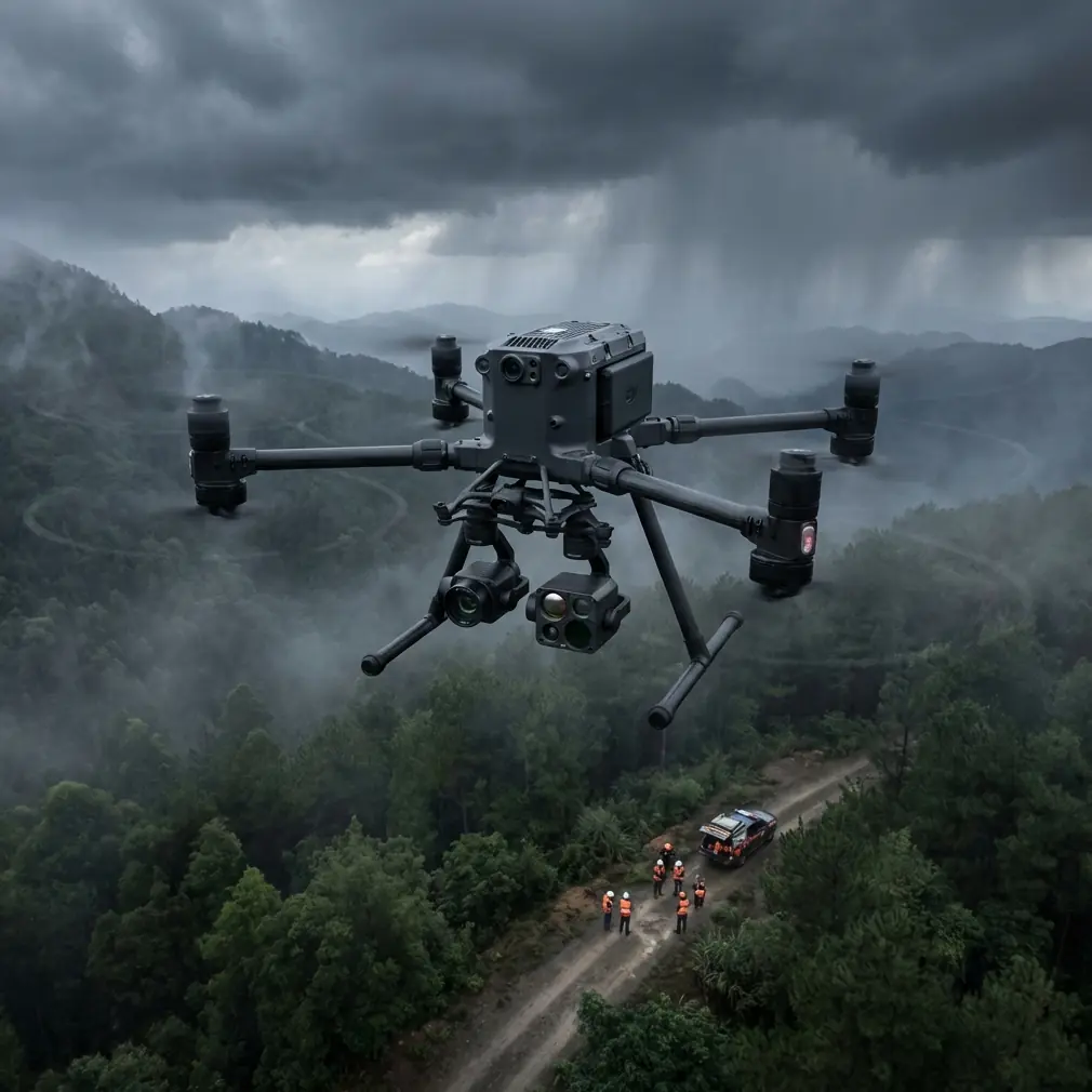
Tall structures can degrade line-of-sight and complicate compass discipline. Reflective surfaces and heat-retaining materials distort the thermal story at certain times of day. Repetitive textures—gravel, bare soil, roofing, parking strips—can reduce tie-point confidence in photogrammetry if your overlap and GCP placement are not thought through. Add traffic, pedestrians, and intermittent RF noise, and suddenly the aircraft’s transmission system and battery strategy matter as much as the camera payload.
This is where two details often overlooked by less experienced operators become operationally decisive: O3 transmission and hot-swap batteries.
O3 transmission is not just a convenience feature. In urban capture, it directly affects mission continuity. When the aircraft is moving along the edge of structures, crossing behind tree lines, or working near sources of interference, a more robust link preserves pilot confidence and reduces unnecessary pauses or conservative aborts. Every interruption in a mapping run introduces inconsistency: different light angles, different thermal conditions, and potentially different site activity. Stable transmission helps preserve the integrity of the dataset, not just the comfort of the person at the controls.
Hot-swap batteries matter for the same reason. Urban field jobs are often permission-sensitive and time-boxed. You may have a narrow morning window before site traffic increases, before rooftop HVAC output changes the local thermal picture, or before sun angle creates harsh shadow contrast across the parcel. Being able to keep the aircraft operational through a fast battery transition reduces downtime between sorties and helps keep your capture conditions consistent across the full mission.
The battery management tip I wish more crews used
Here is the field habit that saves more data quality than most people realize: do not treat all battery changes as equal. Treat them as mission checkpoints.
With hot-swap batteries, teams sometimes become too casual. The temptation is to land, exchange packs quickly, and relaunch immediately because the platform supports it. Technically, that is fine. Operationally, it can be sloppy.
My advice is simple. At every battery swap, take 60 to 90 seconds to verify three things before relaunch:
- Surface heating trend on the site
- Wind shift at your intended mapping altitude
- RTK or GCP continuity for the next block
That short pause pays for itself. Urban parcels change quickly. Asphalt edges warm. Rooftops start radiating. Air currents channel differently around adjacent buildings as the day develops. If you are capturing thermal data or even RGB imagery intended for measurement-grade outputs, those small environmental shifts can split one mission into two slightly incompatible datasets.
I learned this the hard way on a mixed-use redevelopment parcel bordered by warehouse roofs on one side and a scraped field on the other. The aircraft came down for a battery change after the first grid. We relaunched too quickly. Ten minutes later, the roofline was throwing off a stronger thermal signature than in the initial pass, and the breeze had shifted enough to alter the aircraft’s groundspeed behavior on one leg. The data was still usable, but the cleanup workload increased. Since then, I treat each battery event as a calibration moment, not just a power event.
That is the best use of hot-swap capability: not speed alone, but fast continuity with deliberate checks.
Photogrammetry in urban fields: accuracy starts on the ground
For urban field capture, the aircraft can only do part of the job. The rest is discipline in the survey design.
Photogrammetry over open soil or low vegetation near buildings needs stronger ground truth than many operators expect. GCP placement becomes the bridge between airborne efficiency and map-grade confidence. If the site has hard edges, curbs, construction markings, drainage channels, or abrupt elevation breaks, place GCPs to reflect that geometry rather than simply distributing them evenly out of habit.
A common mistake is placing points only around the perimeter. That may work on very simple sites, but urban fields often contain interrupted surfaces and visual clutter. Internal GCPs help the processing engine resolve distortion and improve confidence where textures become repetitive. If your parcel borders structures or vertical objects likely to influence perspective geometry, that central control matters even more.
The Matrice 400 is especially effective in this kind of assignment when operators think beyond “complete coverage” and focus instead on “stable reconstruction.” Those are not the same thing. A mission can cover every square meter and still produce weaker outputs if overlap, speed, and control placement are not adapted to the site.
When teams ask me whether they can skip some GCP work because the aircraft and payload stack are advanced, my answer is direct: technology reduces friction, but it does not repeal geometry. If the final output will support planning, drainage review, quantity checks, or legal boundary context, field control still deserves respect.
Thermal signature: useful, but easy to misuse
The phrase “thermal signature” gets thrown around too casually in urban operations. A thermal image is not automatically a diagnosis. It is a pattern, and patterns require context.
Around urban fields, thermal capture can reveal water retention differences, disturbed ground, subsurface utility clues under certain conditions, edge effects from adjacent built structures, and energy anomalies in bordering assets. But timing is everything. Bare ground, concrete, roofing membranes, vehicles, and shaded zones all heat and cool at different rates. A thermal scene captured at the wrong moment can be technically clean but operationally misleading.
This is why the Matrice 400’s mission reliability matters. If you are trying to compare one section of a field to another, you need a dataset captured under stable conditions with minimal interruption. A dropped link, a delayed relaunch, or inconsistent route timing can distort thermal interpretation. The aircraft is valuable not because it produces thermal imagery in the abstract, but because it supports a repeatable capture process in places where repeatability is fragile.
For crews working next to buildings, I recommend identifying likely thermal contaminants before launch: HVAC exhausts, parked vehicles, dark membrane roofs, glass façades reflecting radiant energy, and recently paved surfaces. Build the flight timing around those realities rather than hoping to filter them out later.
O3 transmission is an operations tool, not a comfort feature
Urban pilots know the feeling of watching a perfectly planned route become tense the moment the aircraft tracks along a cluttered edge of the site. Signal confidence matters because pilot behavior changes when trust in the link drops. People shorten runs. They overcorrect. They interrupt automated patterns too early. Data consistency suffers.
That is why O3 transmission deserves attention in any serious discussion of the Matrice 400 for urban field capture. In dense RF environments, stronger transmission performance supports cleaner execution of preplanned routes and more confidence when monitoring aircraft movement near obstacles or temporary obstructions. That affects not only safety margins but the actual quality of the output.
The same logic applies to BVLOS planning. Even where regulations, waivers, or local operating approvals shape what is possible, the planning mindset is useful. A BVLOS-capable mentality forces crews to think in terms of communication redundancy, route logic, emergency actions, and airspace awareness before takeoff. Even if the mission remains within visual line of sight, that discipline improves outcomes.
Too many teams treat urban field capture like a casual mapping task. It is not casual. It is a structured operation conducted in a complicated environment.
Security is part of the workflow now
Another detail that matters more than it used to is AES-256.
For some readers, encryption sounds abstract compared with batteries, cameras, and route planning. But on urban projects—especially redevelopment sites, municipal parcels, utility corridors, or commercially sensitive properties—data protection is not a side note. Flight logs, imagery, thermal datasets, and site progress records can all carry operational sensitivity.
AES-256 matters because the aircraft is no longer just collecting pictures. It is participating in a data pipeline. If you are documenting strategic infrastructure, land transition, construction staging, or security-relevant perimeters, protecting the transmission and handling of that information becomes part of professional practice. The Matrice 400 fits that expectation when used inside a disciplined workflow that also includes secure storage, controlled export procedures, and clear chain-of-custody habits for deliverables.
In other words, aircraft capability and data governance have finally merged. That is a healthy shift for the industry.
A practical urban capture workflow for the Matrice 400
If I were planning a typical urban field mission with the Matrice 400 tomorrow morning, this is the sequence I would prioritize.
Start with a perimeter walk, not the aircraft. Identify reflective surfaces, likely RF trouble spots, public access points, transient hazards, and any feature likely to corrupt thermal interpretation. Then decide whether the primary deliverable is photogrammetry, thermal analysis, or a hybrid dataset. That choice should dictate time of day and route structure.
Next, establish GCPs with special attention to internal control, not just edge control. If the site has abrupt material changes or elevation breaks, represent them. Then plan flights around transmission confidence, not just geometric efficiency. A theoretically ideal grid that repeatedly tests signal reliability is not ideal in the real world.
Once flying begins, use the hot-swap battery design to preserve environmental continuity. Land with enough reserve to stay disciplined. Swap quickly, but do not relaunch blindly. Check the site again. Has the roofline warmed? Has traffic introduced heat sources? Has the wind shifted down the corridor between buildings? If yes, adjust.
Finally, review a sample of the dataset on site before packing out. Urban jobs generate surprises. Catching one in the field is far cheaper than discovering it in processing.
If your team is refining that workflow and wants a second opinion from someone who works these constraints regularly, you can message our flight operations desk and compare notes before your next mission.
What makes the Matrice 400 genuinely relevant here
The real value of the Matrice 400 in urban field capture is not any single feature in isolation. It is the way several operationally meaningful elements reinforce each other.
Hot-swap batteries reduce the penalty of long missions and make it easier to maintain a stable capture window. O3 transmission supports route continuity where interference and partial obstructions can otherwise degrade execution. AES-256 reflects the reality that site data is often sensitive. When those capabilities are paired with disciplined GCP placement, careful thermal timing, and a BVLOS-style planning mindset, the platform becomes far more than a flying camera.
That is the difference between collecting imagery and producing dependable site intelligence.
Urban field capture rewards crews who think like operators, not hobbyists. The Matrice 400 is at its best in exactly that environment—where signal quality, battery transitions, thermal consistency, geospatial control, and secure data handling all matter at once.
If you are flying this class of mission, that is where your attention should be as well.
Ready for your own Matrice 400? Contact our team for expert consultation.