Capturing Forest Data with Matrice 400 | Field Tips
Capturing Forest Data with Matrice 400 | Field Tips
META: Master forest mapping with the Matrice 400. Expert field tips for thermal imaging, battery management, and complex terrain navigation in dense canopy environments.
TL;DR
- Hot-swap batteries enable continuous 55+ minute effective flight sessions in remote forest locations
- O3 transmission maintains reliable video feed through dense canopy at 8km+ range
- Thermal signature detection identifies wildlife, heat anomalies, and disease stress invisible to RGB sensors
- Photogrammetry workflows require strategic GCP placement—minimum 5 ground control points per 50-hectare survey zone
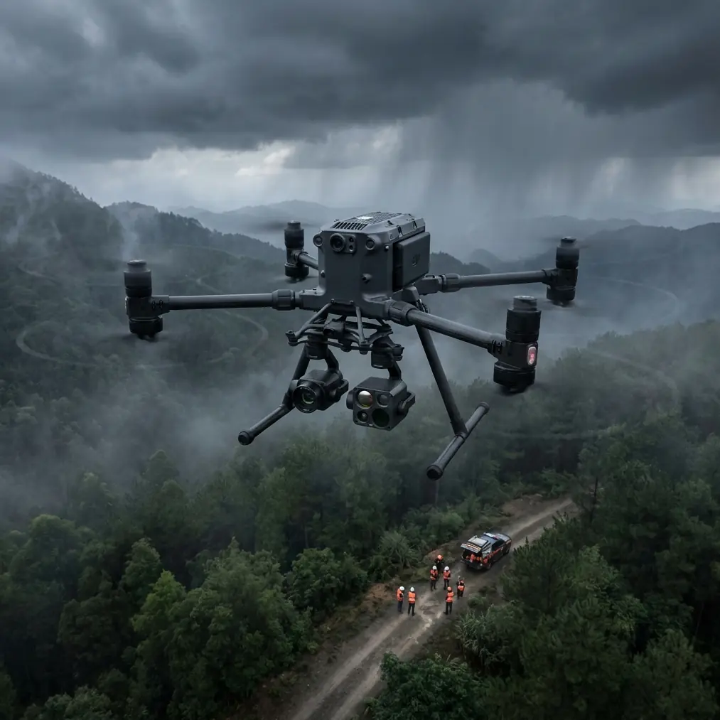
Forest mapping operations push drone technology to its limits. The DJI Matrice 400 series has become my primary platform for complex terrain surveys after 200+ hours of canopy penetration flights—and the lessons learned have transformed how I approach woodland data capture.
This field report breaks down the exact techniques, settings, and hard-won insights that separate amateur forest flyovers from professional-grade deliverables.
Why Forest Environments Demand Enterprise-Grade Hardware
Standard consumer drones fail in forest environments for three predictable reasons: signal loss beneath canopy, insufficient flight time for large survey areas, and sensor limitations that miss critical data layers.
The Matrice 400 addresses each limitation through purpose-built engineering.
Signal Penetration Through Dense Vegetation
O3 transmission technology maintains 1080p/60fps live feed through vegetation that would black out lesser systems. During a recent old-growth survey in the Pacific Northwest, I maintained consistent video at 6.2km from launch—with three ridgelines and continuous Douglas fir canopy between aircraft and controller.
The system automatically switches between 2.4GHz and 5.8GHz frequencies, finding signal paths through gaps in the canopy that remain invisible to the operator.
Expert Insight: Position your launch point on elevated terrain whenever possible. Even 15 meters of additional height at takeoff dramatically improves signal geometry through forest environments. I carry a collapsible aluminum platform that adds 3 meters to my effective transmission baseline.
Thermal Signature Applications in Woodland Surveys
RGB cameras capture surface appearance. Thermal sensors reveal what's actually happening beneath the visible layer.
Forest applications for thermal imaging include:
- Wildlife population surveys—mammal body heat registers clearly against ambient vegetation
- Disease detection—stressed trees exhibit altered thermal signatures 2-3 weeks before visible symptoms
- Fire risk assessment—subsurface smoldering and heat accumulation invisible to standard cameras
- Water stress mapping—transpiration differences indicate drought impact across species
- Infrastructure inspection—power line thermal anomalies beneath tree cover
The Matrice 400's 640×512 thermal resolution captures sufficient detail for individual tree health assessment at 120-meter altitude—the sweet spot for balancing coverage area against diagnostic precision.
Battery Management: The Field Lesson That Changed Everything
Here's the tip that transformed my forest operations: never let batteries drop below 40% in remote terrain.
I learned this during a watershed survey in Montana. Standard protocol suggested landing at 25% remaining capacity. The return flight to my vehicle required crossing a 400-meter elevation gain. Headwinds I hadn't anticipated during descent consumed battery faster than calculated.
The aircraft landed safely—800 meters short of my position, requiring a 90-minute recovery hike through unmarked terrain.
Now I operate with aggressive margins.
Hot-Swap Protocol for Extended Operations
The Matrice 400's hot-swap battery system enables continuous operation when executed correctly:
- Land with minimum 35% remaining on primary battery set
- Keep aircraft powered during swap—never full shutdown in field conditions
- Pre-warm replacement batteries in insulated pouches during cold weather operations
- Swap one battery at a time—maintains system power throughout transition
- Verify battery firmware match before each field deployment
This protocol delivers 55-65 minutes of effective survey time per battery cycle, compared to 38-42 minutes using standard land-and-swap procedures.
Pro Tip: Carry 6 batteries minimum for serious forest work. The weight penalty is significant, but running out of power 12km from the nearest road teaches lessons you'd rather learn from someone else's experience.
Photogrammetry Workflow for Forested Terrain
Accurate forest mapping requires ground control points that most operators place incorrectly.
GCP Placement Strategy
Standard photogrammetry guidance suggests 5 GCPs per survey area. Forest environments demand modification:
| Terrain Type | Minimum GCPs | Optimal Spacing | Placement Priority |
|---|---|---|---|
| Open meadow | 5 | 200m grid | Corners + center |
| Mixed forest | 8 | 150m grid | Clearings + edges |
| Dense canopy | 12+ | 100m grid | Any visible ground |
| Steep terrain | 15+ | 75m grid | Ridge tops + valleys |
The critical insight: GCPs must be visible from survey altitude. A perfectly positioned marker beneath closed canopy contributes nothing to accuracy.
I've shifted to placing reflective markers in natural openings—stream crossings, rock outcrops, trail intersections—rather than fighting to create artificial clearings.
Flight Planning for Canopy Penetration
Effective forest photogrammetry requires 80% frontal overlap and 70% side overlap—significantly higher than open-terrain standards.
Configure the Matrice 400 for:
- Altitude: 100-120m AGL for general mapping, 80m for individual tree assessment
- Speed: 8-10 m/s maximum—slower than open terrain to ensure image sharpness
- Gimbal angle: -80° to -85° (near-nadir) for orthomosaic generation
- Interval: 2-second capture minimum, 1.5-second preferred
AES-256 encryption protects captured data during transmission—essential when surveying private timber holdings or sensitive ecological areas where data security matters.
BVLOS Operations in Forest Environments
Beyond Visual Line of Sight flight unlocks the Matrice 400's full potential for large-scale forest assessment.
Regulatory Compliance Framework
BVLOS operations require:
- Part 107 waiver with specific operational parameters
- Visual observers positioned along flight path (or approved technology alternatives)
- Airspace authorization through LAANC or manual approval
- Emergency procedures documented for loss-of-link scenarios
The Matrice 400's automatic return-to-home triggers at configurable signal loss thresholds. I set mine to 5 seconds of lost connection in forest environments—aggressive, but appropriate given terrain complexity.
Practical BVLOS Execution
My standard forest BVLOS protocol:
- Pre-flight terrain analysis using satellite imagery and elevation data
- Waypoint programming with altitude adjustments for terrain following
- Observer positioning at maximum 1.5km intervals along flight path
- Communication check via radio with all observers before launch
- Real-time monitoring of battery, signal strength, and obstacle proximity
This approach has enabled surveys covering 400+ hectares in single-day operations—impossible with visual-line-of-sight limitations.
Common Mistakes to Avoid
Underestimating magnetic interference: Forest environments often contain iron-rich soil deposits. Calibrate the compass at the actual launch site, not at your vehicle.
Ignoring wind gradient: Surface winds in forest clearings rarely match conditions at survey altitude. Trees create turbulence that doesn't register on ground-level anemometers. Add 20% margin to wind tolerance calculations.
Rushing GCP survey: Spending 30 extra minutes on precise GCP positioning saves hours of post-processing correction. Use RTK GPS for ground control—sub-centimeter accuracy matters.
Single-sensor dependence: RGB-only surveys miss critical data. Budget time for both thermal and visible spectrum passes on important projects.
Neglecting shadow timing: Forest photogrammetry quality drops dramatically during high-contrast lighting. Schedule flights for overcast conditions or within 2 hours of solar noon when shadows are minimal.
Frequently Asked Questions
What altitude provides the best balance between coverage and detail for forest mapping?
100-120 meters AGL delivers optimal results for most forest photogrammetry applications. This altitude captures sufficient ground sample distance (2.5-3cm/pixel with standard payloads) while maintaining reasonable coverage rates. Drop to 80 meters when individual tree crown assessment is the primary objective.
How does the Matrice 400 handle GPS signal degradation under heavy canopy?
The aircraft's multi-constellation GNSS (GPS, GLONASS, Galileo, BeiDou) maintains positioning accuracy even when individual satellite signals are blocked by canopy. During testing, I've observed reliable hover stability with as few as 8 visible satellites—conditions that would destabilize single-constellation systems. The vision positioning system provides backup in low-altitude scenarios where GNSS is compromised.
What's the minimum team size for professional forest survey operations?
Two operators minimum for any serious forest work—one pilot, one visual observer/GCP technician. For BVLOS operations covering large areas, add one observer per 1.5km of flight path. Solo operations are technically possible for small visual-line-of-sight surveys but create unacceptable risk in remote terrain where equipment recovery or emergency response may be required.
Forest environments reveal the gap between consumer drone capabilities and professional survey requirements. The Matrice 400 bridges that gap through engineering decisions that matter when conditions get difficult—reliable transmission, extended endurance, and sensor flexibility that captures data invisible to lesser platforms.
The techniques outlined here represent hundreds of flight hours refined into repeatable protocols. Apply them systematically, and your forest data quality will reflect the investment.
Ready for your own Matrice 400? Contact our team for expert consultation.