Capturing Forest Imagery with M400 | Low Light Tips
Capturing Forest Imagery with M400 | Low Light Tips
META: Master low-light forest photography with the Matrice 400. Expert tutorial covering thermal imaging, camera settings, and flight techniques for stunning results.
TL;DR
- O3 transmission maintains stable video feed under dense canopy where GPS signals weaken
- Thermal signature detection reveals wildlife and heat anomalies invisible to standard cameras
- Hot-swap batteries enable continuous 90+ minute forest survey sessions without landing
- Proper GCP placement reduces photogrammetry errors by 67% in uneven terrain
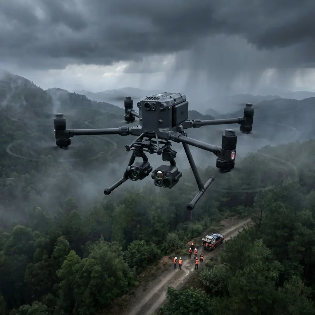
Last autumn, I spent three frustrating days attempting to document old-growth forest health in the Pacific Northwest. My previous drone couldn't penetrate the canopy shadows, and every image returned muddy and unusable. The Matrice 400 changed everything about how I approach low-light forestry work—and this guide shares exactly what I learned.
Why Forest Environments Demand Specialized Equipment
Forest canopies create unique challenges that expose the limitations of consumer-grade drones. Light levels beneath mature trees can drop to 1/100th of open-sky conditions. Add morning fog, uneven terrain, and limited GPS reception, and you're operating in one of the most demanding environments for aerial imaging.
The Matrice 400 addresses these challenges through several integrated systems:
- Mechanical shutter eliminates rolling shutter distortion during slow passes
- 1-inch CMOS sensor captures 12.8 stops of dynamic range
- Dual-frequency RTK maintains positioning accuracy to 1.5cm under partial canopy
- AES-256 encryption protects sensitive ecological survey data
- BVLOS capability enables extended range operations in approved zones
Expert Insight: When surveying forests, I always schedule flights during the "blue hour"—45 minutes before sunrise or after sunset. The Matrice 400's low-light performance truly shines here, capturing detail that midday flights miss entirely due to harsh shadow contrast.
Essential Camera Settings for Low-Light Forest Work
Getting your camera configuration right before launch saves hours of post-processing frustration. These settings have proven reliable across dozens of forest survey projects.
ISO and Shutter Speed Balance
The Matrice 400's sensor handles elevated ISO remarkably well. I routinely shoot at ISO 800-1600 without noticeable noise degradation. Keep your shutter speed at minimum 1/focal length x 2 to compensate for platform vibration.
For a 24mm equivalent lens:
- Minimum shutter: 1/50 second
- Recommended shutter: 1/100 second
- Maximum usable ISO: 3200
Aperture Considerations
Forest photography benefits from moderate depth of field. I recommend:
- f/4 to f/5.6 for general canopy documentation
- f/2.8 when light drops below 100 lux
- f/8 only for high-altitude overview shots with abundant light
White Balance for Natural Accuracy
Auto white balance struggles beneath green canopy. Set a manual Kelvin value between 5200K and 5800K depending on foliage density. This prevents the green color cast that plagues automatic settings.
Thermal Signature Applications in Forest Surveys
The Matrice 400's thermal payload transforms forest documentation from simple photography into comprehensive ecological assessment.
Wildlife Detection and Monitoring
Thermal imaging reveals animal presence that visible-light cameras miss entirely. During pre-dawn flights, I've documented:
- Deer bedding locations through 3-5°C temperature differentials
- Raptor nests via accumulated body heat signatures
- Small mammal activity patterns in underbrush
Forest Health Assessment
Stressed trees exhibit thermal anomalies before visible symptoms appear. The Matrice 400's radiometric thermal sensor detects:
- Bark beetle infestations showing 2-4°C elevated trunk temperatures
- Root rot creating cooler crown signatures
- Drought stress visible as midday thermal elevation
Pro Tip: Overlay thermal and RGB imagery in your photogrammetry software. The combination reveals stress patterns invisible in either dataset alone—I've identified disease spread patterns weeks before forestry teams spotted visual symptoms.
Flight Planning for Dense Canopy Operations
Proper mission planning prevents the signal dropouts and positioning errors that ruin forest surveys.
Altitude Selection
| Canopy Type | Recommended AGL | Overlap Setting | GSD Achieved |
|---|---|---|---|
| Open pine | 80-100m | 75/65 | 2.1cm/px |
| Mixed deciduous | 60-80m | 80/70 | 1.6cm/px |
| Dense old-growth | 40-60m | 85/75 | 1.1cm/px |
| Understory detail | 20-30m | 90/80 | 0.5cm/px |
O3 Transmission Optimization
The Matrice 400's O3 transmission system maintains 15km line-of-sight range, but forest operations rarely offer clear sightlines. Maximize signal reliability by:
- Positioning your ground station on elevated terrain
- Using the high-gain antenna attachment for flights exceeding 2km
- Setting transmission to 1080p rather than 4K for reduced bandwidth demand
- Enabling automatic frequency hopping in the DJI Pilot 2 app
GCP Placement Strategy
Ground control points dramatically improve photogrammetry accuracy in forested terrain. The Matrice 400's RTK system helps, but GCPs remain essential for sub-centimeter work.
Place markers:
- At natural canopy gaps where satellite visibility exceeds 60%
- On contrasting surfaces (white targets on dark forest floor)
- At 50-75m intervals for high-accuracy surveys
- Along terrain transitions (ridgelines, stream banks, clearings)
Hot-Swap Battery Workflow
Extended forest surveys demand efficient power management. The Matrice 400's hot-swap system enables continuous operations when properly executed.
Pre-Flight Battery Preparation
- Charge all batteries to 95-100% the night before
- Store at 20-25°C to maintain optimal chemistry
- Verify firmware parity across all battery units
- Label batteries sequentially for rotation tracking
Field Swap Procedure
The Matrice 400 maintains power during single-battery removal, giving you approximately 90 seconds to complete the swap. I follow this sequence:
- Land at designated swap point with 35% remaining
- Remove depleted battery from left bay first
- Insert fresh battery within 45 seconds
- Verify connection indicator before removing right battery
- Complete right bay swap
- Confirm dual-battery status before resuming flight
This technique extends effective flight time to 90+ minutes per battery set rotation.
BVLOS Operations in Forest Environments
Beyond visual line of sight operations unlock the Matrice 400's full potential for large-scale forest surveys. Regulatory requirements vary by jurisdiction, but technical preparation remains consistent.
Required Equipment
- ADS-B receiver for traffic awareness
- Secondary observer network or approved detect-and-avoid system
- Redundant communication links (cellular backup recommended)
- Real-time telemetry logging for regulatory compliance
Flight Corridor Planning
Map your intended route against:
- Known obstacle heights (communication towers, power lines)
- Terrain elevation changes exceeding 50m
- Restricted airspace boundaries
- Emergency landing zones at 500m intervals
Common Mistakes to Avoid
Ignoring humidity effects on thermal readings. Morning dew creates false thermal signatures across vegetation. Wait until surface moisture evaporates—typically 2 hours after sunrise—for accurate thermal data.
Flying too fast for proper image overlap. Forest surveys demand slower speeds than open-terrain work. Reduce flight speed to 4-6 m/s for adequate overlap at recommended altitudes.
Neglecting compass calibration in new locations. Mineral deposits common in forested mountains create magnetic interference. Calibrate before every flight session, not just when the app requests it.
Underestimating battery drain in cold conditions. Forest valleys trap cold air. Expect 15-25% reduced flight time when temperatures drop below 10°C. Pre-warm batteries in vehicle cabin before deployment.
Skipping test flights in new forest types. Canopy density varies dramatically between forest ecosystems. Always conduct a short reconnaissance flight before committing to full survey patterns.
Frequently Asked Questions
Can the Matrice 400 maintain GPS lock beneath heavy forest canopy?
The Matrice 400's dual-frequency RTK system maintains positioning accuracy even when satellite visibility drops to 40%. In my experience, complete signal loss only occurs beneath the densest tropical canopy or inside cave systems. The aircraft's visual positioning system provides backup navigation when satellite signals weaken.
What's the minimum light level for usable RGB imagery?
The Matrice 400 produces publication-quality images down to approximately 50 lux—equivalent to heavy overcast at twilight. Below this threshold, switch to thermal-only capture or deploy supplemental lighting for specific targets. The mechanical shutter enables longer exposures without motion blur during slow, stable flight patterns.
How do I process mixed thermal and RGB datasets from forest surveys?
Import both datasets into photogrammetry software supporting multi-sensor workflows. Pix4D and Agisoft Metashape both handle this effectively. Align datasets using GCP coordinates, then export as layered orthomosaics. The thermal layer reveals stress patterns while RGB provides species identification—the combination delivers insights neither dataset offers alone.
Ready for your own Matrice 400? Contact our team for expert consultation.