Matrice 400 in Remote Forest Work: A Field Method
Matrice 400 in Remote Forest Work: A Field Method for Cleaner Data, Stronger Links, and Fewer Surprises
META: A practical Matrice 400 guide for remote forest capture, covering photogrammetry, thermal signature work, interference handling, transmission discipline, fatigue-aware operations, and mission planning for dependable results.
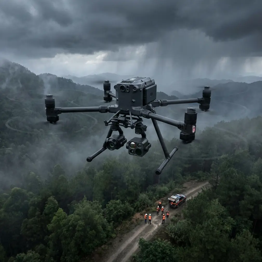
Remote forest operations expose every weakness in a UAV workflow. Dense canopy breaks visual texture. Moisture and uneven terrain complicate launch decisions. Distance stresses the link. Magnetic clutter around field vehicles, towers, and ad hoc power setups can disturb heading stability right when the aircraft is trying to hold a precise line for mapping.
That is where the Matrice 400 conversation becomes useful. Not as a spec-sheet exercise, but as a systems question: how do you build repeatable capture quality when the environment is indifferent to your plan?
I approach that question as a field engineer, not a brochure writer. For readers preparing to use Matrice 400 for forest documentation, habitat assessment, utility corridor review, or land-management imaging, the real challenge is not simply getting the aircraft airborne. It is preserving data quality from launch to final model while staying disciplined about signal integrity, battery transitions, and structural reliability over many repeated missions.
This guide is built around that reality.
Start with the mission physics, not the camera menu
Forests punish lazy planning. If your goal is photogrammetry, the canopy can produce repeating patterns and shadow-heavy surfaces that reduce tie-point confidence. If your goal is thermal signature analysis, sunlight timing and residual heat can distort what looks like meaningful contrast. If your goal is both, the flight profile has to support two very different kinds of evidence.
With the Matrice 400, the right workflow is to define the output before you define the route:
- orthomosaic for stand boundaries
- 3D reconstruction for slope or canopy structure
- thermal scan for water stress, heat leak tracing, or animal-safe environmental surveying
- repeatable corridor capture for longitudinal comparison
This matters because remote forest flights are usually constrained by battery windows, weather gaps, and narrow launch clearings. Every unnecessary pass adds risk and compounds fatigue on aircraft systems and operators alike.
Why transmission discipline matters more in forests than many teams expect
People often assume forests are difficult mainly because they are remote. In practice, some of the hardest link problems come from partial obstructions and local electromagnetic contamination around your own setup.
A common example: the aircraft is stable in open departure, then heading or transmission quality degrades after climbing past a ridge line or tracking near temporary communications gear. On paper, O3 transmission and AES-256-protected links provide a very strong foundation for long-range commercial operations. Operationally, though, signal architecture still depends on field behavior.
In the forest, I tell crews to treat antenna position as an active control variable, not a set-and-forget habit.
What antenna adjustment should look like in the field
If you notice fluctuating downlink quality, intermittent image breakup, or unusual attitude hesitation near a known interference source, do not rush to blame the aircraft. First check the geometry:
- Re-orient the ground antenna array to maintain a cleaner broadside relationship with the aircraft path.
- Move the pilot station away from vehicle roofs, generators, battery inverters, or metal shelters.
- Raise the control position if terrain shadowing is the real cause.
- Reassess whether your route is forcing the aircraft behind dense canopy edges or rocky outcrops at low elevation angles.
That last point is easy to miss. Many “mystery” link issues are simply path obstruction plus poor antenna alignment.
The Matrice 400 becomes more effective when the crew respects the radio environment. In BVLOS planning discussions, this is not a minor detail. It is one of the core determinants of whether your data return is clean and whether your operation remains predictable from leg one to leg ten.
Forest mapping: build overlap around weak visual texture
Dense forest can make photogrammetry look deceptively straightforward. The site is large, the route seems open, and automated lines are easy to generate. But tree crowns often produce highly repetitive texture, moving leaves, shadow pockets, and hidden ground conditions. That weakens reconstruction if your overlaps are only “technically acceptable.”
So for Matrice 400 forest missions, build your overlap strategy around uncertainty rather than minimums. If the terrain is complex, increase frontlap and sidelap beyond your standard open-field template. If wind is moving upper canopy layers, slow down enough to stabilize image consistency. If the mission requires ground truth, deploy GCPs where they will actually survive visibility challenges rather than scattering them optimistically under partial cover.
Good GCP placement in forests usually means edges, breaks, roads, clearings, stream crossings, and exposed surfaces that appear reliably from the planned altitude. A smaller number of visible, defensible control points is better than a larger number of targets buried in foliage.
The Matrice 400’s value here is not just endurance or payload flexibility. It is the ability to execute a disciplined mission profile repeatedly enough that your reconstruction inputs remain consistent over time.
Thermal work in forests: the timing is often more important than the sensor
Thermal signature collection in forest environments is rarely just about finding “hot” and “cold” areas. You may be comparing moisture retention, canopy stress, drainage behavior, exposed infrastructure, or habitat-adjacent anomalies. In each case, timing changes the meaning of the image.
Midday heating can flatten distinctions you needed to see. Early morning can improve some contrasts while introducing dew-related effects. Late afternoon can exaggerate sun-exposed edges and rock outcrops.
The lesson for Matrice 400 crews is simple: thermal missions should be scheduled around the behavior of the site, not around pilot convenience.
If you are pairing thermal with photogrammetry, resist the temptation to force both into one generic sortie unless conditions actually support it. A high-quality thermal layer collected in the wrong time window can be less useful than no thermal layer at all.
The structural lesson hidden in old aerospace references
The reference material behind this article comes from classic aircraft design sources, not a drone user manual. That may sound distant from a Matrice 400 field guide, but it is exactly the kind of engineering perspective commercial UAV teams need as they scale operations.
One source discusses welding design choices for aircraft structures. It highlights why certain processes matter: concentrated heat, strong penetration, small heat-affected zones, and low deformation when welding thin sections. It also notes that some methods can handle weldable thickness around 5 to 8 mm, while maintaining a regular seam profile and limiting distortion.
Why should a forest drone operator care about that?
Because these are not abstract manufacturing notes. They explain the design culture behind airframes and supporting hardware that must tolerate vibration, repeated loading, and transport abuse. Remote forest work means rough access roads, repeated unpacking, hard thermal cycles, and frequent launch-recovery repetition. Components exposed to shock and vibration need joining methods and structural decisions that do not create unnecessary weakness or warping.
The same source also points to materials and welded components intended to carry static, impact, and vibration loads. That language matters in drone operations. Every time your aircraft travels in a truck over rutted roads, every time a payload mount is changed, and every time landing gear sees uneven ground contact, the mission is leaning on a structural philosophy shaped by those same loading concerns.
The practical takeaway: treat airframe inspection as a mission-critical task, especially after transport into remote forest sites. Look for subtle alignment issues, mount looseness, landing gear irregularity, and signs of repeated vibratory stress. Sophisticated aircraft still fail in ordinary ways when crews normalize “small” mechanical drift.
Fatigue data is not academic when you fly the same mission pattern all season
The second reference is even more revealing. It cites an S-N fatigue curve for Inconel 718 thin sheet under elevated-temperature testing, with a sample size of 23, a 60 Hz loading frequency, and an equivalent stress equation used to estimate life. It also includes a warning: beyond a certain stress-ratio range, the life-prediction equation may produce unrealistic results.
That warning deserves more attention in UAV operations than it usually gets.
No, your Matrice 400 is not being flown as a turbine component test article. But the engineering principle transfers perfectly: repeated load cycles do damage in ways operators cannot judge by appearance alone, and simplistic extrapolation can be misleading.
For forest teams, this shows up in three places:
1. Repeated transport and deployment cycles
Remote missions often involve long drives, repacking, and hurried setup on improvised ground. The aircraft may not accumulate extreme flight hours quickly, but it can accumulate a surprisingly high number of handling and vibration cycles.
2. Repetitive flight profiles
Corridor capture, stand inventory grids, and repeat monitoring missions impose consistent patterns of acceleration, deceleration, ascent, descent, and hover correction. Repetition matters.
3. Battery-related operational rhythm
Hot-swap batteries help preserve tempo and reduce downtime, which is excellent for productivity. They also make it easier for teams to string together many sorties in one day and forget that the aircraft and payload mounting system are still experiencing cumulative fatigue exposure.
The real lesson from the fatigue reference is restraint. Do not create your own “unrealistic life prediction” by assuming an aircraft that passed yesterday’s mission is structurally identical today. Build maintenance intervals around mission type and field severity, not just total flight time.
A field workflow that suits the Matrice 400 in remote forests
Here is the method I recommend for a serious capture day.
1. Survey the signal environment before takeoff
Do a quick radio and interference assessment. Identify towers, repeaters, portable power systems, vehicles, and metal clutter. Choose your control point for clean line-of-sight first, convenience second.
2. Check antenna geometry during climbout
Watch link quality as altitude changes. If transmission degrades during the first leg, pause and adjust antenna orientation before committing to a long route.
3. Separate mapping logic from thermal logic
Use one mission profile for geometry and another for heat behavior if the site demands it. Do not dilute both objectives with a compromise route.
4. Use GCPs where the forest permits visibility
Prioritize clearings, access roads, ridge breaks, and exposed surfaces. Confirm they are visible in sample framing before full mission launch.
5. Exploit hot-swap capability with discipline
Hot-swap batteries are valuable in remote work because they preserve continuity and reduce reset time. But use the saved time for checks, not for rushing. Inspect mounts, props, landing interfaces, and payload seating every cycle.
6. Watch for vibration clues after rough transport
Even if the aircraft powers up normally, listen and look for subtle anomalies. The old aircraft-structure literature’s emphasis on impact and vibration loading is directly relevant here.
7. Record environmental context with the dataset
Thermal work especially needs notes on sun angle, cloud cover, moisture, and wind. The image alone is not enough.
When the forest fights the mission, simplify
A surprising amount of good UAV work comes from reducing ambition at the right moment. If interference is persistent, move the station. If canopy motion is severe, postpone the photogrammetry run. If thermal conditions are wrong, wait. If terrain blocks the link, redesign the route instead of forcing range.
The Matrice 400 is best used as a robust platform inside a thoughtful operating system. Not as a substitute for one.
That is also where experienced support can save days of frustration. If you are planning a forest workflow and want to sanity-check transmission setup, payload pairing, or field procedures, you can message a specialist directly here.
The bigger point
Remote forest capture is a reliability exercise dressed up as an imaging mission. Yes, the payload matters. Yes, the aircraft matters. But the difference between mediocre output and dependable output usually comes down to engineering habits: signal management, overlap discipline, timing, inspection routines, and respect for cumulative loading.
The reference documents behind this piece may look far removed from drone fieldwork at first glance. Yet their lessons are exactly the ones that serious Matrice 400 operators should keep close. One emphasizes how joining methods influence deformation, penetration, and resistance to vibration-related demands. The other reminds us that fatigue prediction is conditional, sample-based, and easy to misuse if you extend it beyond its valid operating assumptions.
Applied to remote forest missions, those two ideas become practical rules:
- preserve structural integrity by treating transport shock and repeated loading as real operational variables
- preserve data integrity by treating transmission geometry and interference as active mission controls
Do that, and the Matrice 400 becomes more than a capable aircraft. It becomes a repeatable measurement tool in places where repeatability is hard to earn.
Ready for your own Matrice 400? Contact our team for expert consultation.