Matrice 400 in Remote Highway Work: A Field Report
Matrice 400 in Remote Highway Work: A Field Report from the Edge of Coverage
META: Expert field report on using the DJI Matrice 400 for remote highway capture, covering battery strategy, O3 transmission, thermal workflows, photogrammetry planning, GCP discipline, and BVLOS-ready operational thinking.
Remote highway projects expose every weakness in a drone program.
You are usually far from stable infrastructure. Wind shifts with terrain. Crew movement is awkward. GNSS conditions can change near cuttings, bridges, retaining walls, and heavy vehicles. And unlike a tidy urban façade survey, a highway corridor keeps pulling the aircraft farther from your takeoff point, farther from your visual comfort zone, and farther from the little mistakes you can recover from easily.
That is exactly why the Matrice 400 deserves a serious look for corridor work.
I am not talking about generic “enterprise performance.” I mean the practical reality of sending an aircraft out over long stretches of pavement, embankments, culverts, and roadside assets where data continuity matters more than spec-sheet theatrics. For remote highway capture, the value of the platform shows up in three places: transmission resilience, battery handling discipline, and payload flexibility for mixed survey objectives.
Why the highway environment is harder than it looks
A remote highway mission sounds simple until you define the deliverable.
Sometimes the client wants photogrammetry for a surface model and orthomosaic. Sometimes they want thermal signature checks on drainage anomalies, moisture intrusion, shoulder instability, or heat differences around electrical roadside infrastructure. Sometimes they need repeatable progress capture over weeks, where alignment consistency matters more than one heroic flight. In the real world, you often need all of that in one campaign.
This is where operators get into trouble. They plan one “mapping mission,” then discover the road corridor is really a chain of distinct operating environments: open straightaways, elevated sections, bridge crossings, vegetated margins, construction staging areas, and stretches with poor road access for repositioning the crew.
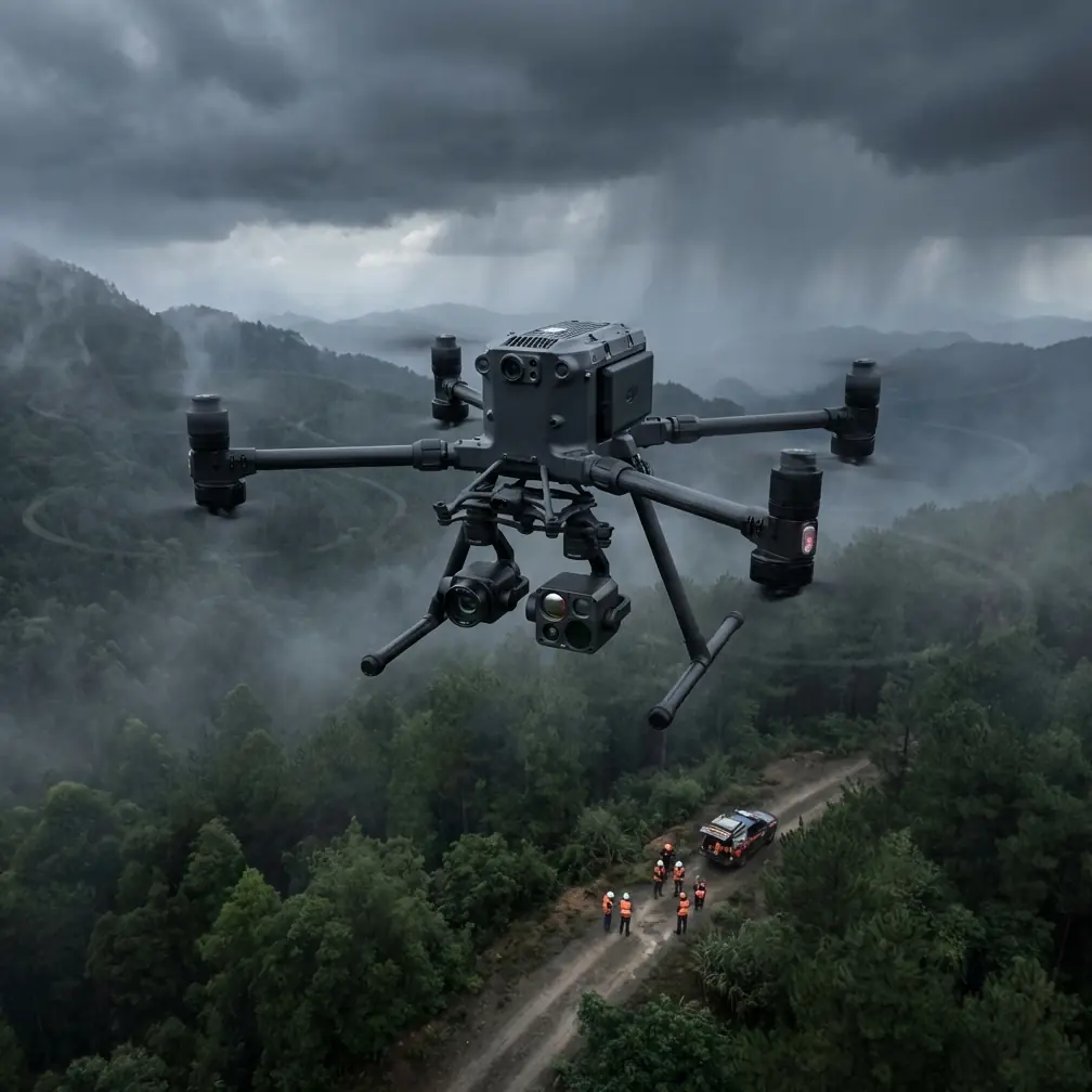
The Matrice 400 fits this kind of work because it is built for professional payload operations rather than recreational convenience. That matters when your job is not merely to fly, but to come back with defensible data.
O3 transmission is not just a convenience feature
In remote highway capture, stable link performance changes how you plan the day.
O3 transmission matters because corridor work tends to stretch the operating geometry in ways that punish weak links. A road does not sit neatly in a compact block below the aircraft. It runs away from you. The aircraft may pass beyond minor terrain undulations, roadside tree lines, structures, or rolling topography that degrade signal quality in subtle ways before the crew even notices.
When operators talk about transmission, they often frame it as a comfort issue. It is more than that. A reliable link preserves decision quality. You can evaluate framing, adjust for changing surface conditions, and maintain confidence in your collection pattern without introducing unnecessary aborts or overly conservative flight segmentation.
For remote highways, that translates into fewer broken data blocks and less stitching pain later.
I would add one operational note here: if your work includes sensitive infrastructure imagery or project documentation, AES-256 encryption is not a box-ticking extra. It is part of client confidence. Highway projects often involve contractors, engineering teams, asset owners, and public-sector stakeholders. Secure transmission and handling become more relevant as data moves beyond simple visual media into inspection-grade or planning-grade deliverables.
Battery management is where good highway crews separate themselves
Here is the field lesson that saves more missions than any marketing phrase ever will: never treat corridor battery planning like point-site battery planning.
A remote highway job tricks crews into thinking efficiency equals flying every pack as deep as possible. That is the wrong instinct.
On highway routes, your reserve is not just for return-to-home distance. It is for the unexpected friction between where the aircraft is and where the landing decision needs to happen. A slow-moving works vehicle may be occupying your preferred recovery spot. Dust can build around a shoulder staging area. Wind at elevation near a bridge deck may be stronger on return than on the outbound leg. If you are collecting overlapping imagery for photogrammetry, the worst possible outcome is a rushed final segment flown by a pilot mentally switching from data discipline to battery anxiety.
My rule from field experience is simple: decide your battery swap point based on mission geometry, not percentage alone.
If the corridor section ahead includes a bridge, terrain break, or complicated traffic-adjacent recovery area, I plan the swap before that section instead of after it. This is where hot-swap batteries become operationally significant. They reduce downtime between flight legs, but the bigger benefit is psychological and procedural: crews are more willing to segment missions intelligently when battery changes do not wreck the rhythm of the day.
That results in cleaner data. Better overlap. Fewer hurried turns. Less temptation to “just finish this pass.”
Hot-swap capability is not exciting to read about. In practice, it is one of the reasons a long linear survey remains orderly after the fifth or sixth flight.
Photogrammetry on highways demands discipline, not just automation
A lot of corridor imagery fails for a boring reason: the operator assumes the software will fix weak field planning.
Highways are unforgiving because they are long, repetitive, and full of subtle elevation changes. The data can look complete while still being difficult to process cleanly. Pavement texture, lane markings, barriers, drainage channels, and embankment transitions all introduce alignment challenges when overlap or perspective control is weak.
With the Matrice 400, the payload ecosystem and enterprise workflow support make it a practical platform for photogrammetry, but the aircraft alone does not guarantee a strong model. Ground control points still matter. GCP strategy becomes even more important in remote segments where visual monotony can make downstream alignment less robust.
I prefer to place GCPs where they stabilize change in geometry rather than simply spacing them by habit. Bridge approaches, intersections with access roads, culvert zones, retaining structures, and elevation transitions usually do more for model integrity than a mathematically neat pattern placed without regard to terrain character.
That is the operational significance. Good GCP deployment reduces expensive rework later, especially when the deliverable is tied to engineering decisions rather than marketing visuals.
For remote highways, I also like to think in terms of “processing confidence zones.” If one stretch has consistent sightlines and simple terrain, it can tolerate a more routine collection profile. The complicated sections need tighter attention to overlap, altitude consistency, and control. The Matrice 400 is most useful here when treated as a precision capture platform, not as a brute-force flyer.
Thermal adds value when used for a question, not as an extra layer
Thermal on highway projects is often misunderstood.
A thermal payload is not there just to make the mission feel more advanced. It becomes valuable when tied to a specific maintenance or inspection question. For example, thermal signature differences can help teams investigate moisture patterns, drainage performance, edge degradation, heat anomalies in roadside electrical assets, or issues that are invisible in a standard RGB pass.
The trick is timing.
On a remote road, thermal collection in poor environmental conditions can produce attractive-looking nonsense. Surface heating, recent weather, shade movement, traffic influence, and material differences all need to be interpreted carefully. The Matrice 400’s strength is that it can support a multi-sensor workflow, allowing teams to compare thermal observations with high-resolution visual context and map-derived location accuracy.
That combination matters because thermal data without context invites overinterpretation. On a corridor, one apparent hotspot may simply reflect pavement composition or sun exposure, while another could point to a drainage problem worth escalating. The aircraft helps because it lets you collect the layers in a unified field operation rather than returning later with a separate platform and introducing more variables.
BVLOS thinking starts long before any formal BVLOS operation
BVLOS is one of those terms people toss around too casually. For highway projects, the useful mindset is not “we are flying BVLOS,” but “are we building a workflow that remains coherent as the corridor extends beyond easy proximity?”
Even when operating within current visual and regulatory constraints, remote highway missions reward BVLOS-style planning. That means disciplined segmentation, communication clarity between crew members, predetermined recovery options, and a transmission strategy that respects the actual terrain rather than idealized line-of-sight assumptions.
The Matrice 400 makes sense in this discussion because it supports serious corridor operations where the mission profile naturally pushes toward extended coverage logic. O3 transmission and encrypted enterprise data handling are part of that picture, but so is the less glamorous side: launch point choice, vehicle leapfrogging, battery staging, and payload-specific flight plans.
A crew that thinks this way today will collect better data now, and it will be better positioned if its regulatory pathway later expands into more advanced corridor operations.
What I would actually do on a remote highway day
If I were deploying the Matrice 400 on a remote highway capture assignment, my day would start with three questions:
- What is the primary deliverable?
- Which sections are geometrically difficult?
- Where will the battery swaps happen before they become urgent?
That third question is the one newer teams often skip.
I would break the route into manageable capture blocks tied to real recovery options, not arbitrary distances. I would separate pure photogrammetry legs from thermal investigation legs unless there is a clear reason to combine them. I would mark sections where GCPs carry outsized value. And I would assume that the “easy” middle part of the route is where complacency is most likely to creep in.
If you are still deciding how to configure a highway workflow around the aircraft, this quick WhatsApp discussion link is the simplest way to compare field setups: https://wa.me/85255379740
Notice what is missing from that plan: any obsession with maximum flight claims or broad feature hype. Long linear jobs punish vanity. They reward repeatability.
The Matrice 400’s real strength is continuity
For remote highway capture, continuity is everything.
Continuity of link. Continuity of power management. Continuity between RGB, thermal, and mapped outputs. Continuity between one flight leg and the next. Continuity in data security when stakeholders need confidence in how imagery is handled.
That is why the Matrice 400 stands out in this niche. Not because it flies, but because it supports a professional workflow where one decision connects cleanly to the next.
And on a highway project, that is the difference between coming home with a folder full of images and delivering a data package that people can actually build, inspect, verify, and act on.
If your work involves remote corridors, do not evaluate the aircraft as a generic enterprise drone. Evaluate it as a field system. Ask whether its O3 transmission helps preserve control over long, awkward route geometry. Ask whether AES-256 supports the data governance your client expects. Ask whether hot-swap battery operations reduce the friction that quietly ruins linear survey efficiency. Ask whether the payload strategy supports both photogrammetry and thermal signature interpretation without turning the day into a patchwork of compromises.
Those are the questions that matter in the dirt, at the shoulder, in the wind, with a half-finished road stretching over the horizon.
That is where the Matrice 400 earns its place.
Ready for your own Matrice 400? Contact our team for expert consultation.