Matrice 400 for Highway Capture in Windy Conditions
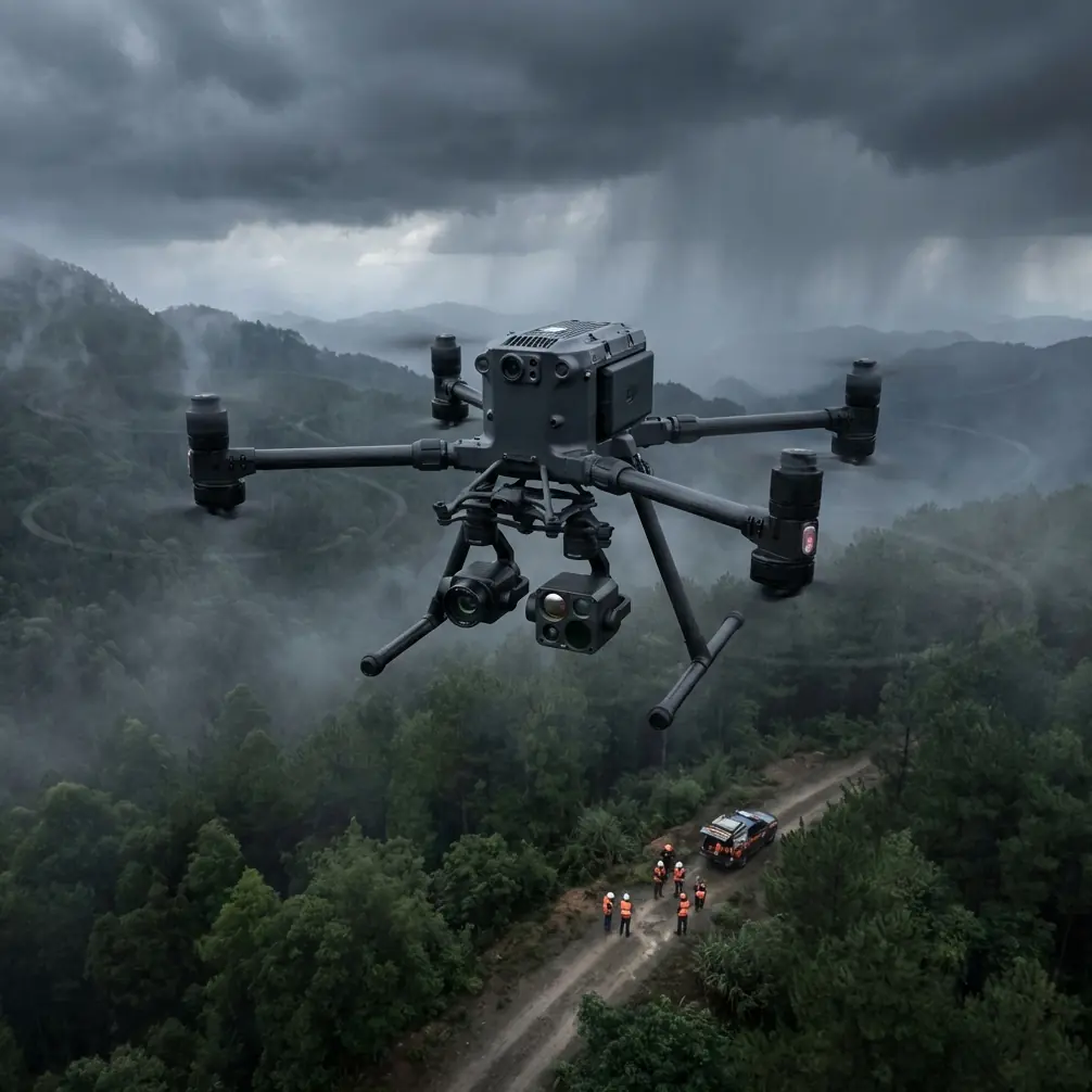
Matrice 400 for Highway Capture in Windy Conditions: A Technical Review from the Field
META: Expert review of the Matrice 400 for highway inspection and mapping in windy conditions, covering flight stability, O3 transmission, hot-swap batteries, AES-256 security, thermal workflows, and photogrammetry accuracy.
Highway work exposes weaknesses fast. Long linear corridors, vehicle turbulence, exposed embankments, bridge approaches, heat shimmer, and crosswinds all stack the deck against the aircraft and the crew. A drone that feels fine over a sheltered jobsite can become frustrating over an elevated roadway where gusts change direction every few seconds.
That is why the Matrice 400 deserves a closer look specifically through the lens of windy highway capture, not as a generic “enterprise drone,” but as a working platform for corridor inspection, thermal assessment, and photogrammetry where consistency matters more than spec-sheet theater.
I approach this as a field problem first. If your assignment is to document pavement conditions, inspect drainage structures, generate measurable corridor models, or record thermal anomalies along a long highway section, the aircraft has to do four things well:
- hold its line in disturbed air,
- maintain a reliable live link along a stretched corridor,
- support quick turnaround between sorties, and
- protect sensitive project data from capture to transfer.
The Matrice 400 stands out because these are exactly the areas where many competing platforms start to show strain.
Why highways in wind are a different kind of drone mission
A highway is not a simple area survey. It is a narrow, elongated operating environment with repeating structures and very little forgiveness for drift. One minute you are flying beside concrete barriers that create localized turbulence. The next you are over a bridge deck with stronger lateral gusts. Then you drop toward culverts or roadside slopes where wind rolls off uneven terrain.
That matters for image quality and for data integrity.
For photogrammetry, crosswind drift changes the consistency of overlap, especially when you are trying to preserve clean geometry along shoulders, medians, retaining walls, and signage. For visual inspection, a small amount of aircraft movement can turn sharp documentation into footage that is hard to interpret. For thermal work, unstable positioning increases the chance of inconsistent viewing angles and mixed readings, which can complicate analysis of moisture intrusion, delamination patterns, overheated electrical cabinets, or friction-related hotspots near infrastructure elements.
This is where the Matrice 400’s platform-level stability becomes more than a comfort feature. It becomes an accuracy feature.
Stability is not just about flying nicely
Many drones can “handle wind” in the marketing sense. The real question is how well they preserve mission quality when the air stops behaving.
On highway capture missions, the Matrice 400’s advantage is not simply that it can remain airborne in difficult conditions. It is that it is built to keep the payload useful while airborne. That distinction matters. A machine that survives gusts but forces constant corrections from the pilot still degrades the result. You may finish the mission, but with weaker imagery, uneven track lines, and more re-flying than expected.
Compared with lighter competitors in the same professional category, a heavier and more purpose-built airframe generally has an edge in wind damping and payload composure. That translates to steadier oblique collections, cleaner nadir runs, and more dependable framing when documenting cracks, guardrail deformation, lane markings, expansion joints, drainage inlets, or bridge attachments.
For highways, that means fewer broken data sets and less time patching holes back at the office.
O3 transmission changes corridor work more than most teams expect
The inclusion of O3 transmission is one of those details that sounds routine until you are halfway down a highway segment and discover how much your workflow depends on link quality.
Corridor missions are especially punishing for the data link. You are not hovering over a compact site with clear geometry. You are often moving along a route with variable elevation, roadside clutter, and occasional structures that interrupt line quality. Even where regulations require visual line of sight, the practical reality is that transmission robustness affects confidence, framing decisions, and abort thresholds.
A stable O3 link gives the pilot and payload operator cleaner situational awareness over distance. That has operational significance in three ways.
First, it reduces unnecessary conservatism. Crews stop cutting missions short just because the feed feels unreliable.
Second, it improves framing discipline. When inspecting signs, barriers, pavement distress, drainage channels, or bridge bearings, a strong live view means fewer missed details and fewer duplicated passes.
Third, it supports safer management of long, segmented corridor jobs. Even if your operating approval does not include BVLOS, the same transmission resilience that benefits extended operations also improves routine visual-line missions in difficult RF and terrain environments.
Competitor platforms often advertise transmission range, but highway professionals know the useful metric is not the maximum number in ideal conditions. It is whether the link remains usable when the corridor geometry gets messy. That is where O3 tends to earn its keep.
Hot-swap batteries are not a convenience on highways. They are a scheduling tool.
Roadway projects are usually constrained by time windows. You may be coordinating around traffic management, lane access, weather openings, contractor activity, or daylight angles needed for inspection. Every minute spent powering down, cooling off, or rebuilding mission continuity costs more than people admit.
Hot-swap batteries directly address that problem.
With the Matrice 400, the ability to exchange power without fully resetting the aircraft workflow is operationally significant because highway capture is rarely a single-flight job. You are moving through repeated launch-recover-relaunch cycles. A system that lets the crew keep the mission cadence tight reduces exposure to changing winds and shifting light. It also makes it easier to hold a consistent acquisition standard across multiple segments.
That consistency is a quiet but major quality driver. Photogrammetry suffers when battery changes create long interruptions and changing environmental conditions between blocks. Thermal inspection can also become harder to compare if sections are captured under drifting surface temperatures or altered sun loading. Faster turnaround helps preserve continuity.
Against less efficient field workflows on competing systems, hot-swap support is one of the Matrice 400’s strongest real-world advantages. It is not glamorous. It is productive.
AES-256 matters when the highway project is sensitive
Highway and transport work often involves infrastructure owners, engineering firms, concession operators, and public agencies. The collected material may include unfinished works, restricted access zones, bridge details, traffic systems, utility crossings, or thermal evidence tied to maintenance planning. Even if the mission is entirely civilian, the data can still be commercially sensitive.
That is why AES-256 deserves more attention than it usually gets.
This is not just a cybersecurity bullet point. It affects how comfortably organizations can deploy drones on projects where image streams, mission files, and stored captures must be handled with care. For firms managing compliance obligations or client confidentiality, stronger encryption reduces friction in the approval process and makes enterprise adoption easier.
When comparing platforms, this is one of the places where the Matrice 400 looks more mature than lower-tier alternatives. Those aircraft may be good image collectors, but they are not always built around the governance standards expected in infrastructure programs.
If your team is bidding for repeat highway inspection contracts, secure architecture is part of operational credibility.
Thermal signature work: where platform steadiness meets interpretation quality
The mention of thermal signature is not incidental. Highways create legitimate thermal use cases that go beyond dramatic imagery.
Thermal payload workflows can help identify moisture-related issues, insulation irregularities in adjacent structures, electrical problems in roadside systems, heat patterns around mechanical installations, and sometimes early material deterioration signatures when interpreted carefully and within proper environmental windows. On bridges and elevated transport assets, thermal imaging can also contribute useful context during condition screening.
The problem is that thermal data is easy to oversell and easy to compromise.
If the aircraft is unstable in wind, angle changes and motion can produce inconsistent observations. If the mission pace is too slow because battery changeovers are clumsy, the surface temperature profile may shift before the corridor is complete. If the link is unreliable, the operator may miss subtle anomalies in real time.
The Matrice 400 helps on all three fronts: stable platform behavior, efficient battery workflow, and dependable live transmission. That does not replace good thermography practice, but it gives the payload a better chance to produce interpretable data.
For crews combining RGB and thermal capture on the same roadway asset, that integration is a practical strength rather than a theoretical one.
Photogrammetry, GCPs, and why wind tolerance affects mapping accuracy
Highway mapping is where many teams discover whether their aircraft is truly professional or merely capable.
A long corridor model demands discipline in overlap, altitude control, and image geometry. Add wind, and the aircraft can begin to crab, yaw-compensate, or vary ground speed enough to introduce inconsistencies. Those errors then show up later as soft edges, alignment issues, or weak reconstruction in repetitive surfaces.
The Matrice 400’s value in photogrammetry lies in helping preserve acquisition quality before the software stage. Better flight stability means more uniform image spacing and more repeatable viewing angles. That improves the odds that your processing pipeline delivers a corridor model you can trust.
Ground control points, or GCPs, still matter. A stable aircraft does not eliminate the need for sound control strategy, especially on long transport alignments. But better raw capture reduces the burden on the adjustment process. In plain terms, you are asking your software to refine good data instead of rescue marginal data.
For teams producing orthomosaics, surface models, cut-and-fill references, drainage studies, or as-built documentation, that difference is substantial. The Matrice 400 is not magic. It simply starts the photogrammetry chain with fewer preventable defects.
Where it beats typical competitors
The easiest way to compare the Matrice 400 with competing enterprise drones is to focus on one windy highway morning.
A lighter platform may get airborne quickly and produce acceptable footage when conditions are mild. But once gusts build, its weaknesses start to compound. The live feed becomes less reassuring over a long corridor. The aircraft needs more active correction. Battery transitions interrupt the rhythm. Thermal passes become harder to standardize. Mapping blocks require more caution to avoid drift-driven inconsistency.
The Matrice 400 excels because it behaves like a system designed for difficult field days, not just clean demonstrations.
Its O3 transmission supports corridor confidence.
Its hot-swap batteries preserve mission tempo.
Its AES-256 framework supports enterprise deployment.
Its stable platform behavior helps both thermal interpretation and photogrammetry quality.
That combination is what sets it apart. Not one isolated feature. The stack.
Practical capture tips for windy highway operations with the Matrice 400
If I were preparing a crew for a real highway mission in wind, I would focus on process as much as hardware.
Plan shorter corridor segments than you think you need. Wind changes faster than road geometry. Breaking the mission into logical sections improves data consistency and makes relaunch decisions cleaner.
Use GCPs strategically rather than uniformly. Place them where geometry changes, elevation shifts, or critical engineering references need the strongest confidence.
Prioritize obliques on structures that create wind turbulence. Barrier interfaces, bridge edges, gantries, and drainage assets often need extra attention because wind-driven aircraft movement can hide the detail if you rely only on a standard pass plan.
For thermal work, capture as consistently as possible within a narrow environmental window. The Matrice 400’s hot-swap workflow helps, but mission discipline still decides whether the data is comparable from one section to the next.
Watch traffic-induced airflow around large vehicles. On some road classes, the local disturbance from trucks can be more disruptive than the background wind.
And if your team wants a field-specific workflow discussion for corridor inspection, mapping setup, or payload selection, you can reach a specialist directly via this project chat link.
The bigger takeaway
The Matrice 400 is not interesting because it is new, large, or enterprise-branded. It is interesting because its design choices align unusually well with the demands of highway capture in wind.
That alignment shows up in practical ways: cleaner corridor operations with O3 transmission, faster sortie turnover through hot-swap batteries, stronger data governance with AES-256, and better payload usefulness when the air is unstable. Add thermal and photogrammetry workflows to the equation, and the aircraft starts to look less like a general platform and more like a serious transport-infrastructure tool.
For teams capturing highways, that is the real benchmark. Not whether the drone can fly in wind, but whether it can still produce work you are willing to deliver.
Ready for your own Matrice 400? Contact our team for expert consultation.