Capturing Power Lines with Matrice 400 | Wind Tips
Capturing Power Lines with Matrice 400 | Wind Tips
META: Master power line inspections in windy conditions with the Matrice 400. Expert tips on thermal imaging, battery management, and BVLOS operations for reliable results.
TL;DR
- Wind tolerance up to 15 m/s makes the Matrice 400 ideal for power line inspections in challenging weather
- O3 transmission technology maintains stable video feed at distances exceeding 20 km for BVLOS operations
- Hot-swap batteries enable continuous flight operations without powering down the aircraft
- Thermal signature detection identifies faulty connections and overheating components invisible to standard cameras
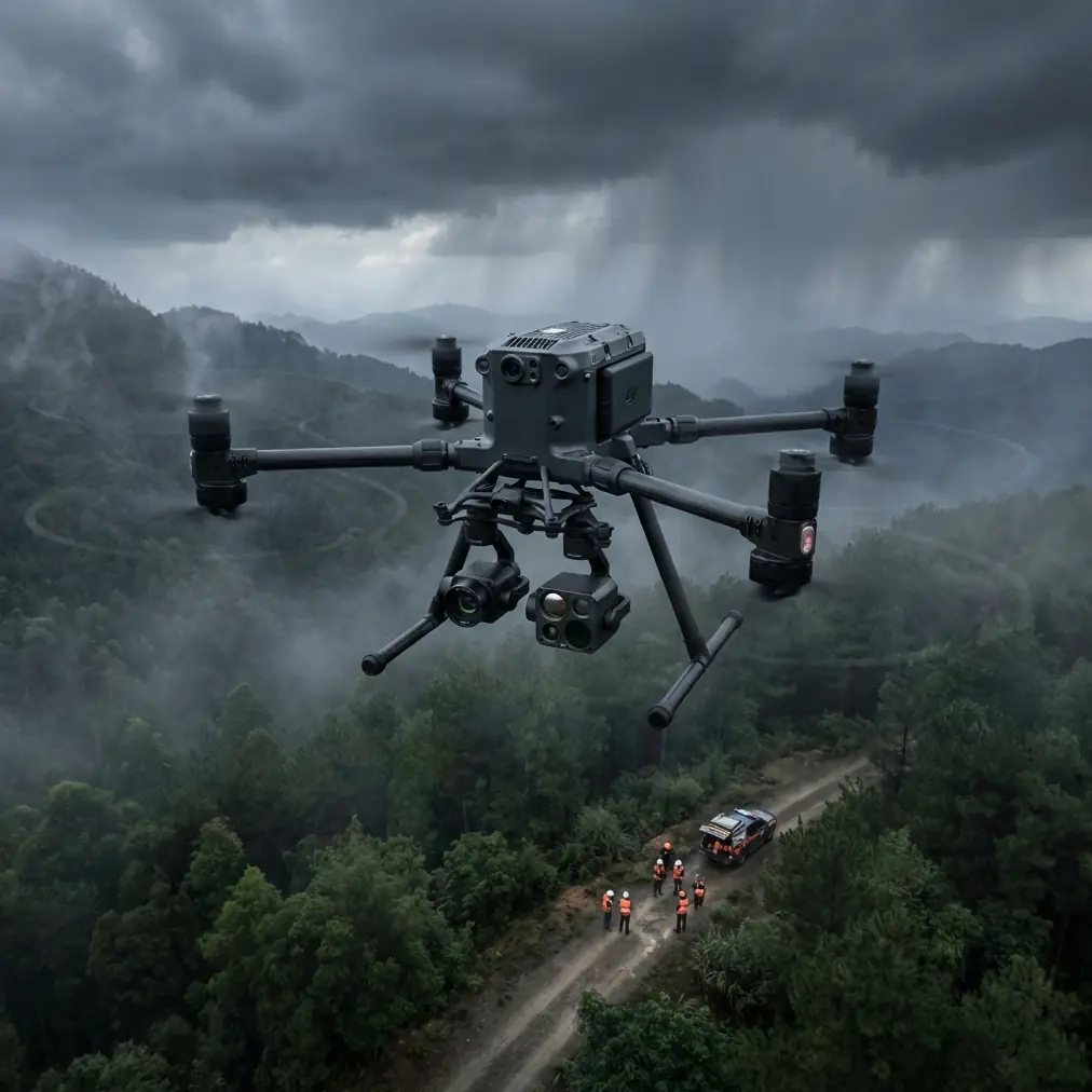
Power line inspections in windy conditions separate professional drone operators from amateurs. The DJI Matrice 400 series addresses this challenge with industrial-grade stabilization and transmission systems that maintain operational integrity when gusts threaten mission success. This guide breaks down the specific techniques, settings, and workflows that maximize inspection quality while minimizing weather-related failures.
The Wind Challenge in Power Line Inspections
High-voltage transmission lines often traverse exposed terrain—mountain ridges, coastal areas, and open plains—where wind speeds regularly exceed 10 m/s. Traditional inspection methods using helicopters cost upwards of 2,000 per hour and still face weather limitations. Ground-based inspections miss critical overhead components entirely.
The Matrice 400 changes this equation with its 15 m/s wind resistance rating and advanced flight controller algorithms that compensate for turbulence in real-time. But raw specifications only tell part of the story.
Understanding Thermal Signature Detection
Faulty electrical connections generate heat before they fail catastrophically. The Matrice 400's Zenmuse H30T payload captures thermal signatures with 640×512 resolution at frame rates sufficient for detailed analysis during flight.
Key thermal indicators on power infrastructure include:
- Hot spots at connection points indicating loose hardware or corrosion
- Uneven heating patterns along conductors suggesting internal damage
- Insulator temperature differentials revealing contamination or cracking
- Transformer thermal anomalies predicting imminent failure
Expert Insight: I learned early in my inspection career that thermal readings fluctuate significantly with wind speed. A 5 m/s crosswind can reduce apparent surface temperatures by 8-12°C through convective cooling. Always document wind conditions alongside thermal captures and apply correction factors during analysis.
Battery Management: Field-Tested Strategies
Here's a technique that saved countless missions during my years inspecting transmission corridors in the Pacific Northwest. The Matrice 400's hot-swap battery system allows continuous operation, but the real advantage comes from strategic battery rotation.
The Three-Battery Rotation Protocol
Maintain three battery sets in rotation:
- Active set currently powering the aircraft
- Warm standby set at 25-30°C ready for immediate deployment
- Charging set connected to field charging station
This rotation ensures you never wait for batteries and never fly with cold cells that reduce capacity by up to 30% in temperatures below 10°C.
Temperature Conditioning Tips
- Store batteries in insulated cases with hand warmers during cold weather operations
- Pre-warm batteries to 20°C minimum before flight in winter conditions
- Monitor individual cell voltages through the DJI Pilot 2 app—variance exceeding 0.1V between cells indicates potential issues
- Allow 15-minute cool-down periods after high-drain flights before recharging
Pro Tip: Mark your batteries with colored tape and log flight cycles for each set. Batteries with more than 200 cycles should be relegated to training flights, not critical inspection missions where maximum endurance matters.
Photogrammetry and GCP Integration
Power line corridor mapping demands centimeter-level accuracy for asset management databases. The Matrice 400 supports photogrammetry workflows that generate precise 3D models when combined with proper ground control point placement.
GCP Placement Strategy for Linear Assets
Unlike area surveys, power line corridors require linear GCP distribution:
| GCP Position | Spacing | Purpose |
|---|---|---|
| Tower bases | Every 3rd tower | Vertical accuracy control |
| Access roads | 500m intervals | Horizontal tie points |
| Corridor edges | 250m staggered | Cross-track accuracy |
| Terrain changes | At elevation breaks | DTM accuracy |
Minimum GCP count for a 5 km corridor: 12-15 points distributed according to this pattern.
Camera Settings for Photogrammetric Capture
Optimal settings for the Zenmuse P1 on power line missions:
- Shutter speed: 1/1000s minimum to eliminate motion blur
- Aperture: f/5.6 for maximum sharpness across frame
- ISO: Auto with 800 maximum limit
- Overlap: 80% frontal, 70% side for dense point clouds
- Flight altitude: 40-60m AGL depending on conductor sag
O3 Transmission: Maintaining Link Integrity
The Matrice 400's O3 transmission system represents a significant advancement for BVLOS power line operations. With theoretical range exceeding 20 km and AES-256 encryption, the system maintains both connection stability and data security.
Practical Range Considerations
Real-world performance depends on:
- Electromagnetic interference from high-voltage lines (expect 15-20% range reduction near 500kV+ conductors)
- Terrain masking in mountainous regions
- Antenna orientation relative to transmission towers
- Weather conditions affecting signal propagation
Optimizing Transmission Performance
Position your ground station with these factors in mind:
- Elevate antennas 2-3m above ground using tripod mounts
- Maintain line of sight to the operational area
- Orient directional antennas toward the flight path center point
- Avoid positioning near metal structures or vehicles that create multipath interference
Technical Comparison: Matrice 400 vs. Previous Generation
| Specification | Matrice 400 | Matrice 300 RTK | Improvement |
|---|---|---|---|
| Max wind resistance | 15 m/s | 12 m/s | 25% |
| Transmission range | 20 km | 15 km | 33% |
| Max flight time | 50 min | 55 min | Comparable |
| IP rating | IP55 | IP45 | Enhanced |
| Hot-swap batteries | Yes | No | New feature |
| Encryption standard | AES-256 | AES-256 | Maintained |
| Max payload | 2.7 kg | 2.7 kg | Maintained |
| Operating temp range | -20 to 50°C | -20 to 50°C | Maintained |
The hot-swap capability alone justifies the upgrade for professional inspection teams conducting extended corridor surveys.
BVLOS Operations: Regulatory and Technical Requirements
Beyond visual line of sight operations unlock the Matrice 400's full potential for power line inspection. A single operator can survey 50+ km of corridor in a single day with proper authorization and procedures.
Technical Prerequisites
- ADS-B receiver integration for traffic awareness
- Redundant communication links (cellular backup recommended)
- Automated return-to-home triggers for link loss scenarios
- Real-time telemetry logging for regulatory compliance
Flight Planning Essentials
- Map all obstacles within 100m of planned route
- Identify emergency landing zones every 2 km
- Pre-program altitude adjustments for terrain following
- Establish communication checkpoints with ground observers
Common Mistakes to Avoid
Flying too close to conductors during thermal capture. Electromagnetic fields affect compass accuracy within 15m of high-voltage lines. Maintain 20m minimum separation and use visual positioning rather than GPS near towers.
Ignoring wind gradient effects. Ground-level wind measurements underestimate conditions at 50-100m AGL by 30-50%. Use weather stations with elevated sensors or apply correction factors.
Rushing battery swaps. Hot-swap capability tempts operators to minimize ground time. Take 60 seconds to verify battery seating, check propeller condition, and confirm sensor calibration before resuming flight.
Overlooking GCP accuracy verification. Survey-grade GCPs require RTK positioning with 2cm horizontal accuracy. Consumer GPS units introduce errors that compound across photogrammetric models.
Neglecting AES-256 security protocols. Utility infrastructure data carries security implications. Enable encryption, use strong passwords, and follow data handling procedures specified in your contract.
Frequently Asked Questions
What wind speed should cancel a power line inspection mission?
Sustained winds above 12 m/s with gusts exceeding 15 m/s warrant mission postponement. While the Matrice 400 tolerates these conditions, image quality degrades significantly due to platform movement, and thermal readings become unreliable from convective cooling effects.
How many batteries are needed for a 20 km corridor inspection?
Plan for 6-8 battery sets depending on payload configuration and wind conditions. The Zenmuse H30T draws more power than lighter payloads, reducing flight time to approximately 35-40 minutes per set. Include 20% reserve for repositioning and contingencies.
Can the Matrice 400 detect vegetation encroachment on power lines?
Yes, combining RGB photogrammetry with LiDAR payloads enables precise vegetation clearance measurement. The platform supports the Zenmuse L2 for 3D point cloud generation that identifies trees and growth within conductor safety zones with centimeter-level accuracy.
Ready for your own Matrice 400? Contact our team for expert consultation.