Matrice 400 in Complex Terrain: A Technical Review
Matrice 400 in Complex Terrain: A Technical Review for Venue Capture Teams
META: Expert technical review of Matrice 400 workflows for capturing venues in complex terrain, with practical insight on verification, transmission, thermal payload use, and reliability details that matter in the field.
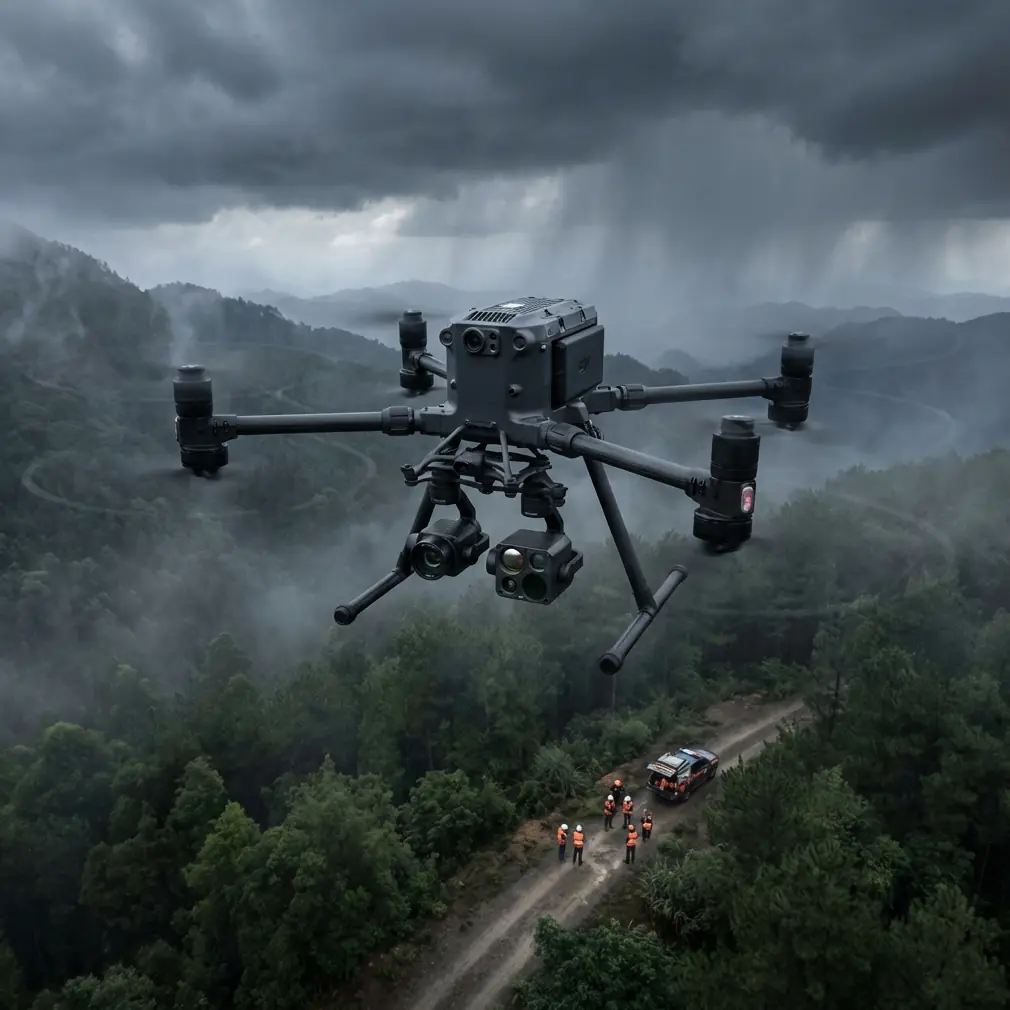
When a venue sits in broken terrain, the drone platform stops being a spec sheet exercise. Ridge shadow, uneven launch points, shifting wind, mixed surfaces, tree lines, reflective roofs, and tight flight geometry all pile onto the same mission. That is where the Matrice 400 conversation gets serious.
For teams handling venue capture, the real question is not whether the aircraft can fly. It is whether the system can deliver repeatable, clean, defensible data when terrain and structure complexity begin to interfere with line of sight, image consistency, and operational margin. That is the lens I want to use here.
I am not treating the Matrice 400 as a generic flagship. I am looking at it as a working tool for venue documentation, photogrammetry, thermal signature review, and planning flights in places where the ground itself creates problems.
Why complex terrain changes everything
A flat sports field is forgiving. A venue built into hillsides or surrounded by elevation shifts is not. In these environments, a pilot is constantly managing three layers at once:
- aircraft stability in changing air
- sensor consistency for usable capture
- communication confidence when geography begins to obstruct the link
That third point gets underestimated. On paper, strong transmission solves a lot. In practice, complex terrain can create partial masking and changing geometry between aircraft and operator. This is why O3-class transmission capability matters less as a marketing badge and more as an operational buffer. When the aircraft moves from open frontage to a back slope or behind architectural mass, link resilience directly affects whether the mission stays orderly or becomes improvisational.
For venue teams collecting imagery for planning, design, digital twins, or progress records, stable transmission also supports cleaner decision-making during the flight. You catch coverage gaps while airborne instead of discovering them later in processing.
A venue capture aircraft has to be judged like an aircraft system
One of the most useful reference points in aircraft engineering is not glamorous at all: documentation discipline. The design verification material in the civil aircraft handbook lays out what proper test reporting should contain. Not just a conclusion, but the purpose of the test, the equipment used, installation method, calibration state, procedure, delays and reasons, data processing methods, post-test inspection, and final findings.
That framework is highly relevant to a Matrice 400 venue workflow.
Why? Because venue capture in difficult terrain often ends up supporting downstream decisions with real financial and scheduling consequences. If a team is building a terrain model, checking thermal anomalies on a roof system, or producing photogrammetry outputs that architects and owners will rely on, “the drone flew fine” is not enough. A professional Matrice 400 operation should mirror that verification mindset:
- define flight objective before launch
- document payload configuration
- record battery state and swap intervals
- note wind, launch elevation, and terrain masking points
- preserve transmission quality observations
- verify coverage and post-flight anomalies
- keep data handling secure
The handbook’s reporting logic is especially useful here because it ties performance to traceability. In other words, you can explain not only what was captured, but how and under what conditions. That matters for repeat surveys and for comparing venue changes over time.
What an old aircraft hose standard tells us about modern drone reliability
At first glance, a standards section on hose assemblies and anti-abrasion sleeves looks far removed from a Matrice 400 mission. It is not.
The source material references hose and fitting dimensions in inches, including a component table with entries such as 0.50, 0.625, and 1.00, plus a design note calling for tube end design per NAS 1760 at two ends. It also mentions a sleeve being heat-shrunk to fit tightly, along with anti-chafe treatment for tubing.
This is a small but revealing reminder of what separates aviation-grade thinking from consumer-grade thinking: interfaces fail where friction, vibration, sealing, and fit are neglected.
For Matrice 400 users, the operational lesson is straightforward. In venue capture work, the weak point is often not the airframe or the camera. It is the interface layer around them. Payload mount security, cable routing, environmental sealing, strain relief, and anti-abrasion protection all become more important when flights involve repeated elevation transitions, long mission blocks, or transport through rough access routes.
That is also where third-party accessories can genuinely improve capability. I have seen teams gain reliability by adding a well-designed third-party cable management and payload protection kit, especially for mixed visible and thermal payload work. It sounds mundane until a connector rub point or loose routing introduces intermittent sensor dropouts halfway through a terrain-following venue run. Good accessory design is rarely exciting. It is just what keeps a long day productive.
The aviation handbook’s emphasis on anti-wear sleeving and controlled dimensions translates cleanly to drone operations: don’t treat accessory integration casually. If a venue mission depends on a payload stack, mount it like it matters.
Photogrammetry in complex terrain: consistency beats ambition
A lot of venue operators try to solve difficult terrain with brute-force overlap. That often creates more processing load without fixing the real issue, which is inconsistent capture geometry.
The Matrice 400 becomes valuable here if it is used to reduce variation, not simply to fly farther.
For photogrammetry, the priorities in complex terrain are:
- stable altitude strategy relative to the subject
- disciplined overlap adapted to slope breaks
- reliable GCP integration
- careful management of shadows and reflective surfaces
- field verification before leaving site
Ground control points are still one of the most effective ways to keep venue models honest, especially when the site includes retaining walls, terraced seating, roof transitions, service roads, and vegetation boundaries. If the terrain is producing vertical complexity, GCP placement should reflect that rather than clustering near easy access zones. A strong aircraft does not remove the need for good survey logic.
This is where Matrice 400-class endurance and hot-swap batteries become practical rather than luxurious. Venue capture rarely fails because of one dramatic event. It fails because operators rush the second half of a job. Hot-swap capability helps preserve mission rhythm. You keep the aircraft active, maintain field momentum, and close coverage gaps while conditions are still similar. For terrain-sensitive photogrammetry, that continuity can make post-processing far easier.
Thermal signature work: the venue story you cannot see in RGB
Venue capture is no longer just about creating a pretty orthomosaic. Thermal signature review has become valuable for roof inspection, drainage assessment patterns, façade envelope concerns, utility hotspots, and selective maintenance planning.
Complex terrain adds a twist. It changes sun exposure, air drainage, and moisture behavior across the property. A structure on a slope may present thermal variation that has as much to do with topography as with the building system itself. If you are flying the Matrice 400 with a thermal-capable payload, the mission design should reflect that.
The best teams pair thermal flights with visible-light context capture in the same operational window whenever possible. That reduces interpretation errors later. A warm patch on a roof edge means something different when you can cross-reference slope, drainage path, and adjacent mechanical placement from RGB data.
Transmission reliability again matters here. Thermal interpretation can depend on seeing subtle patterns in real time and deciding whether to adjust angle, altitude, or pass direction before leaving the site. If terrain intermittently compromises the operator’s situational awareness, the value of the thermal mission drops.
Security and data custody are not side topics
Venue data can be sensitive even when the use case is purely commercial. Construction staging, private event layouts, utility placements, and high-value facility details all deserve responsible handling.
That is why AES-256 deserves mention in a Matrice 400 workflow discussion. Not because encryption sounds impressive, but because modern drone missions increasingly sit inside larger client data governance expectations. If your venue capture operation is moving imagery, thermal records, and mapping outputs across teams, secure transmission and controlled handling should be part of the workflow from the start.
This is another place where the design-verification mindset from civil aircraft practice is useful. Calibration status, test setup, procedure, data correction methods, and result reporting were all highlighted in the reference material for a reason. Good data is not just accurate. It is managed in a way that other professionals can trust.
BVLOS thinking, even when you are not flying BVLOS
BVLOS is often discussed as a regulatory category, but it is also a planning mindset. Complex terrain punishes assumptions about visibility and command reliability. Even on missions that remain within standard visual frameworks, venue teams benefit from planning as if they must actively manage aircraft state, link robustness, return routing, terrain shielding, and contingency paths.
The Matrice 400’s value grows when the crew uses that discipline. Think in segments:
- open approach leg
- structure-side pass
- rear-slope coverage
- thermal detail orbit
- reconstruction pass for missed geometry
This segmented method creates cleaner logs, easier battery planning, and better fault isolation if one section needs to be re-flown. It also aligns with the structured test procedure logic found in the aircraft verification reference: objective, setup, execution, recorded results, review.
A practical field stack for difficult venues
If I were advising a team using Matrice 400 on a complex-terrain venue assignment, I would prioritize the following stack:
- RGB capture plan for base photogrammetry
- thermal pass if building envelope or utilities matter
- properly distributed GCPs across elevation changes
- hot-swap battery workflow to preserve capture continuity
- O3 transmission awareness around terrain masking zones
- encrypted data handling with AES-256-enabled workflow
- accessory integration that protects cables, connectors, and payload mounting points
If your team is evaluating payload integration details or accessory compatibility for this kind of work, a direct technical chat often solves more than a spec comparison page ever will: message a Matrice workflow specialist here.
What separates acceptable results from professional results
Professional venue capture in complex terrain is less about headline capability than about error control.
The reference materials point to two principles that deserve more attention in drone operations.
First, dimension and interface discipline matter. The hose standard’s attention to measured diameters at two locations, anti-chafe treatment, and controlled end design reflects an engineering culture obsessed with fit, wear, and repeatability. For Matrice 400 users, that translates into respecting every payload interface, cable path, and mounting decision.
Second, validation must be documented. The civil aircraft testing reference does not allow hand-waving. It expects a report to include test purpose, equipment, procedure, data treatment, inspection results, and conclusions. Venue capture teams should adopt the same seriousness, especially when outputs are feeding architects, asset managers, surveyors, and owners.
Those two habits—respect for interfaces and respect for documentation—do more to elevate Matrice 400 operations than any single sensor upgrade.
Final assessment
The Matrice 400 makes sense for venue capture in complex terrain when the operator needs more than aerial coverage. It is a platform for controlled, repeatable acquisition under conditions that tend to expose weak links in planning, communications, and payload integration.
Its real strength shows up when several needs overlap: photogrammetry that must hold up across elevation changes, thermal signature review that benefits from live interpretation, longer mission blocks supported by hot-swap batteries, secure data practices, and transmission performance strong enough to tolerate imperfect geography.
Used casually, it is just a large capable aircraft. Used with an aircraft-grade mindset, it becomes a dependable survey and inspection system.
That difference is what serious venue teams should focus on.
Ready for your own Matrice 400? Contact our team for expert consultation.