Field Report: Capturing Venues in Complex Terrain
Field Report: Capturing Venues in Complex Terrain with Matrice 400
META: Expert field report on using Matrice 400 for venue capture in difficult terrain, with operational insights on transmission reliability, photogrammetry workflow, weather shifts, and why control architecture matters.
By James Mitchell
A venue looks simple on a brochure map. In the field, it rarely is.
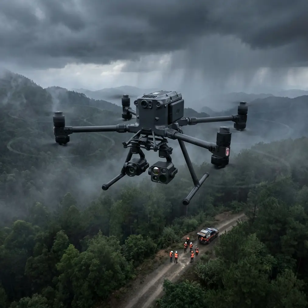
The assignment was to capture a large outdoor venue built into broken terrain: stepped access roads, uneven ridgelines, mixed tree cover, temporary structures, and a patchwork of reflective roofs that can confuse both visual interpretation and automated reconstruction. This is the kind of site where a drone either becomes a precision tool or a liability. There is not much middle ground.
For this job, the Matrice 400 made sense not because of branding, but because venue capture in complex terrain is a systems problem. You need clean image geometry for photogrammetry, stable transmission when line-of-sight quality changes across elevation, and enough operational resilience to keep the mission intact when the weather shifts halfway through the day.
That last part happened.
The mission profile
The brief was broader than “take aerial photos.” The client needed a usable digital venue record. That meant:
- high-overlap mapping passes for photogrammetry
- oblique image sets for structural context
- thermal signature checks over selected service areas
- repeatable flight lines for future change comparison
- secure handling of collected site data
Ground control points were placed before first launch, with special attention to elevation variation rather than just horizontal spread. On flat sites, some crews treat GCP layout as a box-ticking exercise. In complex terrain, bad control placement shows up later as warped edges, elevation drift, and messy stitch lines around slopes or retaining walls.
The Matrice 400’s value here is not one isolated feature. It is the way the aircraft supports disciplined data capture under conditions that are rarely ideal.
Why transmission quality matters more in venue work than many crews admit
A lot of pilots talk about payloads first. For venue capture, I often start with link stability.
Complex venues create their own signal problems. Grandstands, steel-framed buildings, temporary event infrastructure, tree lines, and terrain breaks all interrupt the visual and radio logic of a neat mission plan. A mapping route that looks fine in software can feel very different once the aircraft drops behind a ridge shoulder or passes a reflective roof line that complicates perception and orientation.
That is where a robust O3 transmission environment earns its place. Reliable downlink is not just about keeping live video pretty on a screen. It affects mission confidence, real-time framing decisions, safety margins, and the ability to verify data quality before landing. If you discover after touchdown that you lost image consistency over a difficult section, you are not saving time. You are burning daylight.
On this site, transmission quality mattered most on the far edge of the venue where the terrain folded away sharply. We were still operating inside a carefully planned civilian inspection workflow, but the topography created moments where a weaker link would have forced slower repositioning or conservative route changes. The Matrice 400 held the mission together by keeping the aircraft usable as a capture platform instead of turning it into a tentative scout.
For teams planning large venue documentation, that difference is operational, not cosmetic.
Mid-flight weather change: where platform behavior becomes obvious
The morning started clean. Light air, stable visibility, good contrast on the ground.
About halfway into the second mapping block, the weather shifted. Wind picked up through the saddle on the western side of the site, and the lighting flattened as a cloud bank moved in. Anyone who works terrain regularly knows this pattern: one part of the venue remains manageable while another suddenly starts producing uneven motion, harder exposure decisions, and a noticeable rise in pilot workload.
This is where poor aircraft composure leaves fingerprints all over the dataset.
The Matrice 400 stayed settled enough to preserve the mission logic. We adjusted the sequence, moved the most elevation-sensitive lines forward, and deferred a lower-priority oblique pass until the air steadied. Hot-swap batteries helped here in a practical way. Instead of rushing to compress remaining flight tasks into one cycle, we could keep the workflow modular: land, review, swap, relaunch, and continue without rebuilding the entire day around battery downtime.
People often reduce battery discussion to endurance alone. For venue work, the bigger issue is continuity. Hot-swap capability protects the structure of the survey. If conditions change mid-operation, you can pause intelligently rather than forcing the aircraft and crew into a rushed compromise.
That mattered on this site because the wind change did not ruin the day. It simply demanded better pacing.
Photogrammetry in broken ground: where discipline beats optimism
There is a common mistake in venue capture: assuming that dense image count can compensate for weak mission planning. It cannot.
Photogrammetry over complex terrain depends on geometry, consistency, and control. A venue with elevation change, retaining features, tree margins, and temporary structures needs carefully managed overlap and viewing angles. If your aircraft can hold route integrity and give you confidence in the link, the rest becomes a matter of method.
We used a layered capture approach:
- Primary nadir mapping for base reconstruction
- Supplemental obliques around terrain transitions
- Focused thermal signature passes over selected infrastructure zones
- Verification imagery where slope and structure density interacted
The Matrice 400 fit this kind of modular workflow well because the platform did not force unnecessary resets between capture goals. That sounds small until you are on a live site with changing light and a limited access window.
The thermal signature component was especially useful around service corridors and roof transitions. Not because thermal replaces visible-spectrum mapping, but because it can reveal inconsistencies that are easy to miss in standard imagery alone. For venue operators, that can support maintenance planning, drainage assessment, and infrastructure checks without adding a separate site visit.
Secure data handling is not a side note
Venue capture often involves more sensitive site information than people realize. Access paths, utilities, temporary operations layouts, roof conditions, and service zones can all appear in the collected data. If the venue is private, under development, or preparing for a public event, those details matter.
That is why secure transmission and data management should be built into the aircraft decision, not treated as an afterthought. AES-256 matters here because it supports a more defensible handling posture for operational imagery and telemetry during commercial work. Not every client asks for it by name, but many expect the underlying discipline.
If your workflow includes remote review, distributed teams, or future BVLOS-oriented planning under the right regulatory framework, security architecture becomes even more relevant. The aircraft is not just collecting pictures. It is participating in a professional data chain.
What an older control-systems reference still teaches us
One of the more interesting things in the reference material is not about the Matrice 400 directly at all. A control systems document from 2016 lists open and proprietary autopilot ecosystems, including Dronecode, 3DR DroneKit, DJI Developer resources, and even the older DJI Matrice 100 with DJI Guidance.
That detail matters because it shows how far professional multirotor operations have evolved. Earlier platform discussions often revolved around whether an aircraft could be integrated into custom control logic or development frameworks at all. Today, with a platform like Matrice 400, the expectation is higher. Operators are no longer asking only whether the aircraft can fly a mission. They want stable automation, reliable sensing, secure communications, and workflow compatibility across capture, analysis, and repeat operations.
The operational significance is straightforward: venue capture has matured from aerial photography into managed data acquisition. The aircraft has to support that full stack.
Referencing the Matrice 100 era is useful because it highlights the shift. Back then, integration itself was a talking point. Now the benchmark is whether the platform can execute consistently in the field while supporting advanced mission design and dependable outputs. For complex venues, that is a meaningful difference.
A surprising lesson from an aircraft sealing handbook
The second unusual reference is a Chinese aircraft design handbook page discussing hydraulic seals, leakage testing, and friction behavior under pressure. At first glance, it seems unrelated to venue capture. It is not.
One specific detail stands out: when system pressure rises above roughly 100 to 200 lb/in², the mechanical tension of the seal assembly can become negligible in friction calculations, while friction caused by hydraulic pressure scales with pressure itself. Another concrete detail is the leak test condition at 3000 lb/in², followed by a check at 750 lb/in², with seal performance judged against defined leakage limits.
Why bring that into a Matrice 400 field report? Because it reflects a broader truth about professional aircraft design: performance in the field depends on understanding how components behave under load, not under idealized assumptions.
For drone operators, the takeaway is practical. Robust mission performance is the result of engineering margins, system integration, and tested behavior when pressure, vibration, heat, and environmental change interact. When the weather shifted on our venue mission, the aircraft’s composure was not magic. It was a byproduct of design discipline.
Commercial crews do not need to calculate seal friction in pounds to appreciate the point. But they should respect what sits behind stable aircraft behavior. Reliable capture platforms are built, tested, and validated around exactly these kinds of engineering realities.
Where Matrice 400 helps most on difficult venue sites
After enough field days, certain patterns become obvious. The Matrice 400 is at its best when the job has several of the following traits at once:
- variable elevation
- interrupted sightlines
- mixed mapping and inspection goals
- pressure to keep flights repeatable
- a need for secure data handling
- a schedule vulnerable to changing weather
That combination describes many real venues: hillside resorts, amphitheaters, race facilities, utility-heavy event grounds, campuses with dramatic topography, and construction-linked public spaces.
The drone’s advantage is not that it removes complexity. It lets you manage complexity without degrading the dataset.
If I were advising a team preparing for a similar assignment, I would stress four things.
First, build your GCP plan around elevation behavior, not just area coverage.
Second, use transmission confidence to your advantage. Verify difficult sections while airborne rather than trusting that everything will reconstruct later.
Third, separate mission layers. Nadir, oblique, and thermal work should support each other, not compete for airtime in a rushed sortie.
Fourth, plan battery cycles around weather and terrain, not just the published endurance idea. Hot-swap batteries are most valuable when they preserve decision quality.
Final field note
This venue was not extreme by rescue standards, and it was not especially remote. That is exactly why it is a useful case study. Most commercial drone work happens on sites that are complicated enough to expose weakness, but ordinary enough that crews can underestimate them.
The Matrice 400 handled the day well because it supported disciplined capture through terrain variation, transmission challenges, and a mid-flight weather shift that could easily have undermined the survey. O3 transmission stability helped maintain control over the far side of the venue. Hot-swap batteries preserved workflow continuity when conditions changed. AES-256 aligned with the realities of handling sensitive site data. And a photogrammetry plan anchored by properly placed GCPs turned raw flights into a dataset the client could actually use.
If you are planning venue documentation in similarly awkward ground, that is the real standard. Not whether the drone can get airborne, but whether it can deliver order when the site does not.
If you want to compare mission architecture for your own terrain-heavy venue workflow, you can message our flight team here.
Ready for your own Matrice 400? Contact our team for expert consultation.