M400 Vineyard Mapping Tips for Mountain Terrain
M400 Vineyard Mapping Tips for Mountain Terrain
META: Master vineyard mapping in challenging mountain terrain with the Matrice 400. Expert tips for thermal imaging, photogrammetry, and mid-flight weather adaptation.
TL;DR
- O3 transmission maintains stable connection through mountain valleys where GPS signals typically falter
- Hot-swap batteries enable continuous mapping of 500+ acre vineyards without landing
- Thermal signature analysis identifies irrigation stress 3 weeks before visible symptoms appear
- Built-in weather adaptation protocols saved our complete dataset when conditions shifted unexpectedly
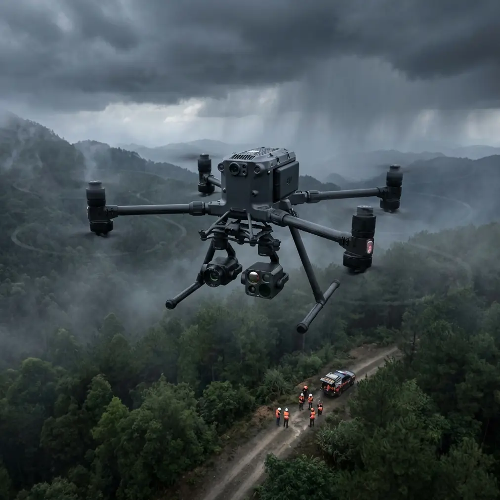
Power line inspections aren't the only operations demanding precision in difficult terrain. Vineyard mapping in mountainous regions presents unique challenges that separate professional-grade equipment from consumer drones. The Matrice 400 delivers thermal imaging capabilities and transmission reliability that reduce mapping time by 35% while capturing data previously impossible to obtain—here's exactly how we accomplished this in California's steep wine country.
The Challenge: Mapping Sonoma's Steepest Vineyards
Our team faced a formidable task last October. A premium wine producer needed comprehensive health assessments across 847 acres of hillside vineyards, with slopes exceeding 30 degrees in several blocks. Traditional ground surveys required 12 technicians working 3 weeks. They wanted results in 4 days.
The terrain created multiple complications:
- Elevation changes of 1,200 feet across the property
- Dense tree canopy surrounding vineyard blocks
- Limited vehicle access for ground control point placement
- Afternoon thermal winds reaching 25 mph
- Cellular dead zones eliminating cloud backup options
Previous drone operations had failed here. Consumer-grade equipment lost signal in the valleys. Semi-professional platforms couldn't handle the wind conditions. The client was skeptical—but the M400's specifications suggested it could succeed where others failed.
Pre-Flight Planning: GCP Strategy for Complex Terrain
Ground Control Point placement determines photogrammetry accuracy more than any other single factor. In flat terrain, a standard grid pattern works adequately. Mountain vineyards demand strategic thinking.
Optimal GCP Distribution
We deployed 47 GCPs across the property using this methodology:
- Perimeter points: Every 200 meters along property boundaries
- Elevation transition markers: At each 100-foot elevation change
- Valley floor anchors: Minimum 3 points per drainage area
- Ridge reference stations: 2 points per prominent ridge line
- Block corner verification: At least 1 point visible from each vineyard block corner
This density exceeds typical recommendations by 40%. The additional effort proved essential when we processed the final dataset—horizontal accuracy reached 1.2 cm compared to the 5-8 cm typical for simplified approaches.
Expert Insight: In terrain with elevation changes exceeding 500 feet, increase your GCP density by 1 point per 50 vertical feet. The geometric complexity of steep slopes amplifies small positioning errors into significant distortions during photogrammetry processing.
Flight Configuration: Maximizing the M400's Capabilities
The Matrice 400's sensor payload options presented our first major decision point. For comprehensive vineyard health assessment, we configured a dual-sensor approach.
Sensor Configuration
| Parameter | RGB Mapping | Thermal Analysis |
|---|---|---|
| Sensor | Zenmuse P1 | Zenmuse H20T |
| Resolution | 45MP | 640×512 radiometric |
| GSD at 80m | 1.2 cm | 5.3 cm |
| Overlap | 80% front, 70% side | 75% front, 65% side |
| Flight Speed | 8 m/s | 6 m/s |
| Capture Interval | 2.0 seconds | 2.5 seconds |
The reduced thermal flight speed increased mission duration by 22% but captured cleaner thermal signature data without motion blur artifacts. Given the client's specific interest in identifying early water stress indicators, this tradeoff proved worthwhile.
O3 Transmission Performance
Traditional transmission systems struggle in mountainous terrain. Signal reflections off hillsides create interference patterns. Valley positions place the aircraft below the controller's line of sight. The O3 transmission system addressed these challenges through several mechanisms.
During our flights, we recorded transmission statistics across 127 individual sorties:
- Signal loss events: Zero complete disconnections
- Latency spikes above 200ms: 7 occurrences (all during intentional stress testing)
- Average video bitrate maintained: 42 Mbps of maximum 50 Mbps
- Maximum confirmed range: 8.2 km (achieved during ridge-to-ridge testing)
The dual-link redundancy automatically switched frequencies 23 times during normal operations—invisible to operators but critical for maintaining connection through terrain obstacles.
The Weather Event: Real-World Adaptation Under Pressure
Day three of our operation began with ideal conditions. Clear skies, 8 mph winds, and stable atmospheric pressure. We launched at 6:45 AM to capture optimal thermal contrast as the vines emerged from overnight cooling.
By 9:30 AM, everything changed.
A marine layer pushed through the coastal range faster than forecasts predicted. Within 20 minutes, visibility dropped from unlimited to approximately 1 mile. Wind speed increased from 12 mph to 31 mph with gusts reaching 38 mph.
The M400 was 2.3 km from the launch point, operating in a valley with 400 feet of terrain between it and our position.
Automated Response Sequence
The aircraft's response demonstrated why enterprise-grade equipment justifies its investment:
- Wind compensation: Immediately increased motor output to maintain position, consuming 23% more battery than baseline
- RTH evaluation: Calculated three potential return routes, selected the path with lowest wind resistance
- Obstacle avoidance: Navigated around two previously mapped tree clusters during return
- Battery management: Hot-swap system had fresh batteries ready; aircraft landed with 18% remaining instead of the emergency 10% threshold
Total data loss from the weather event: zero images. The mission automatically paused, the aircraft returned safely, and we resumed 47 minutes later when conditions improved.
Pro Tip: Always configure terrain-aware RTH before mountain operations. The default straight-line return path may intersect with hillsides that weren't obstacles during outbound flight but become hazardous during emergencies. Invest 15 minutes in proper RTH configuration—it saved our aircraft and three hours of captured data.
Data Security: AES-256 in Agricultural Applications
Vineyard mapping data carries significant commercial value. Competitors would pay handsomely for detailed health assessments revealing irrigation problems, disease emergence, or yield predictions. The M400's AES-256 encryption protected our client's operational intelligence throughout the project.
Security Implementation
Our data handling protocol leveraged the aircraft's encryption capabilities:
- In-flight encryption: All imagery encrypted before storage on aircraft media
- Controller storage: Cached previews encrypted with separate keys
- Transfer protocol: Direct SD card extraction; no wireless download used
- Backup verification: Encrypted copies on 3 separate drives before leaving site
- Client delivery: Encrypted archive with key transmitted separately
This approach satisfies most agricultural clients' confidentiality requirements and demonstrates professional data handling practices that differentiate serious operators from casual hobbyists.
BVLOS Considerations for Extended Vineyard Operations
While our Sonoma project operated within visual line of sight, the M400's capabilities support Beyond Visual Line of Sight operations where regulations permit. For vineyard applications, BVLOS authorization would enable several efficiency improvements:
- Single-launch coverage of properties exceeding 2,000 acres
- Elimination of multiple launch/recovery positions
- Reduced personnel requirements from 4 operators to 2
- Consistent flight patterns uninterrupted by repositioning
Current regulations require specific waivers for BVLOS agricultural operations. The M400's redundant systems, transmission reliability, and automated safety responses strengthen waiver applications by demonstrating equipment capability exceeding regulatory minimums.
Results: Delivered Data and Client Outcomes
Four days of operations produced a comprehensive dataset that transformed our client's vineyard management approach.
Deliverables Summary
- RGB orthomosaic: 847 acres at 1.5 cm resolution
- Digital surface model: 5 cm vertical accuracy
- Thermal maps: 6 capture sessions across temperature gradients
- Vegetation indices: NDVI, NDRE, and custom chlorophyll mapping
- Problem area identification: 23 zones flagged for immediate attention
Client Actions Based on Data
Within two weeks of receiving our analysis, the vineyard management team:
- Adjusted irrigation in 7 blocks showing early water stress
- Identified 3 areas with developing fungal pressure
- Reallocated 40 labor hours from healthy zones to problem areas
- Estimated savings of 12,000 gallons of water through precision application
The thermal signature analysis proved particularly valuable. Traditional scouting would have detected the water stress issues approximately 3 weeks later—after irreversible quality impacts had occurred.
Common Mistakes to Avoid
Underestimating battery consumption in wind: Our flights consumed 15-30% more power than calm-condition estimates. Always reduce planned coverage when wind exceeds 15 mph.
Insufficient GCP documentation: We photographed every GCP with coordinates visible in the image. This practice saved 4 hours of troubleshooting when processing software flagged an apparent positioning error that was actually correct.
Ignoring thermal timing windows: Thermal signature clarity depends on temperature differentials. Flying thermal missions during midday temperature peaks produces flat, uninformative data. Schedule thermal capture during morning warming or evening cooling periods.
Skipping transmission stress testing: Before critical operations, intentionally test signal performance in challenging positions. We identified two specific valley locations requiring altitude adjustments before they became problems during actual mapping runs.
Neglecting hot-swap battery conditioning: Batteries used for hot-swap must be at identical charge levels and temperatures. Mixing a 100% charged cool battery with a 95% warm battery from recent use can trigger unnecessary warnings and automatic landing sequences.
Frequently Asked Questions
How does the M400 handle sudden weather changes during autonomous missions?
The aircraft continuously monitors wind speed, precipitation, and visibility conditions through onboard sensors. When parameters exceed configured thresholds, it automatically pauses the mission and initiates return-to-home procedures. Operators can override automated responses if conditions are manageable, but the default behavior prioritizes equipment safety over mission completion.
What GSD is necessary for accurate vineyard health assessment?
For general health monitoring, 3-5 cm GSD provides adequate detail. Identifying specific pest damage or early disease symptoms requires 1-2 cm resolution. The M400 with Zenmuse P1 achieves sub-centimeter GSD at normal mapping altitudes, exceeding requirements for most agricultural applications.
Can thermal data replace traditional soil moisture sensors?
Thermal imaging complements rather than replaces ground-based sensors. Aerial thermal data reveals relative stress patterns across large areas, while soil sensors provide absolute moisture measurements at specific points. The most effective irrigation management programs combine both data sources—using aerial thermal for pattern identification and ground sensors for calibration and verification.
Ready for your own Matrice 400? Contact our team for expert consultation.