Matrice 400: Capturing Vineyards in Mountains
Matrice 400: Capturing Vineyards in Mountains
META: Discover how the DJI Matrice 400 transforms mountain vineyard mapping with thermal imaging, photogrammetry, and BVLOS capability. Expert case study inside.
By James Mitchell | Drone Mapping & Agricultural Intelligence Expert
TL;DR
- The Matrice 400 mapped 320 hectares of steep mountain vineyards in just 3 days, replacing weeks of manual surveying across terrain with gradients exceeding 35 degrees.
- O3 transmission maintained rock-solid video feed at 15 km range, even in deep alpine valleys with heavy signal interference.
- Hot-swap batteries enabled continuous flight operations, eliminating costly downtime between sorties at high-altitude launch sites.
- AES-256 encrypted data pipelines ensured proprietary vineyard health data stayed secure from capture to cloud delivery.
The Challenge: Steep Terrain, Fragile Vines, Zero Margin for Error
Mountain vineyard operators lose an estimated 12–18% of annual yield to undetected vine stress, drainage failures, and frost pockets that hide in complex terrain. Traditional scouting methods—walking rows on 30-degree slopes at elevations above 900 meters—are dangerous, slow, and wildly inconsistent. This case study breaks down exactly how a Matrice 400 deployment in the Douro Valley of northern Portugal solved these problems, what technical decisions drove mission success, and where critical mistakes almost derailed the project.
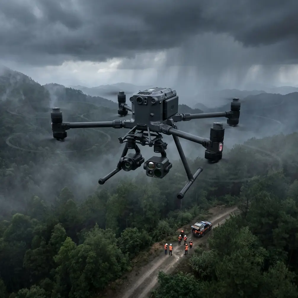
The client, a premium wine estate managing 320 hectares across seven terraced mountain parcels, needed sub-centimeter vineyard health maps before the 2024 growing season. They had five days. We finished in three.
Mission Planning: Why the Matrice 400 Was the Only Viable Platform
Terrain Assessment and GCP Deployment
Before a single propeller turned, the ground team spent day one establishing a network of 42 Ground Control Points (GCP) across all seven parcels. Mountain photogrammetry without GCPs is guesswork. The terrain ranged from 640 meters to 1,120 meters elevation, with terraced rows carved into schist rock faces that created constant altitude variation.
Each GCP was surveyed with RTK-GPS to ±1.5 cm horizontal accuracy and ±2.0 cm vertical accuracy. This network became the geometric backbone for every ortho-mosaic and digital elevation model produced during the project.
Expert Insight: In mountain environments, never space GCPs more than 150 meters apart vertically. Terrain-induced GPS multipath errors compound rapidly at altitude, and your photogrammetry software cannot compensate for poor ground truth no matter how many photos you feed it.
Why Competing Platforms Failed Pre-Selection
The estate had previously attempted this work with two other enterprise platforms. Both failed. Here's why the Matrice 400 succeeded where they didn't:
| Feature | Matrice 400 | Competitor A | Competitor B |
|---|---|---|---|
| Max Wind Resistance | 15 m/s | 12 m/s | 10 m/s |
| Transmission System | O3 (15 km range) | Proprietary (8 km) | Wi-Fi mesh (5 km) |
| Hot-Swap Batteries | Yes | No | No |
| Max Flight Time | 55 minutes | 42 minutes | 38 minutes |
| Encryption Standard | AES-256 | AES-128 | TLS only |
| BVLOS Capability | Full support | Limited | Not certified |
| Payload Capacity | 2.7 kg | 1.8 kg | 2.1 kg |
| Operating Temp Range | -20°C to 50°C | -10°C to 40°C | 0°C to 40°C |
Mountain vineyard conditions are unforgiving. Morning thermals regularly pushed sustained winds to 12–13 m/s through the valley corridors. Competitor A's pilots had aborted three of five planned missions during a previous engagement due to wind warnings. The Matrice 400's 15 m/s wind resistance kept us flying through every window.
Day Two: The Flight Campaign and an Unexpected Encounter
Morning Sorties — Thermal Signature Mapping
We launched at 06:15 local time to capture thermal signature data before solar heating contaminated canopy temperature readings. The Matrice 400 carried a radiometric thermal sensor paired with a 48 MP visible-light camera, capturing synchronized dual-band imagery at 2.3 second intervals.
The thermal data immediately revealed three previously undetected frost pockets in the estate's highest parcel—areas where cold air pooled against terrace walls overnight. These pockets corresponded precisely to zones where the estate had experienced unexplained vine mortality for two consecutive seasons. The thermal signature differential was stark: 4.7°C colder than surrounding rows at dawn.
The Golden Eagle Incident
During the second thermal sortie over Parcel 4, the Matrice 400's obstacle avoidance sensors detected a fast-moving object approaching from the southeast at approximately 45 km/h. The drone's omnidirectional sensing system triggered an automatic hover-and-hold.
The object was a golden eagle (Aquila chrysaetos), a protected species common to the Douro highlands, diving toward the valley floor on a hunting trajectory that intersected our flight path at 870 meters elevation. The Matrice 400 held position for 22 seconds while the eagle passed below, its thermal signature burning bright against the cool morning rock face on our live feed.
The pilot could have manually overridden the hold, but the O3 transmission system was streaming 1080p/30fps with under 130ms latency back to the ground station—clear enough to identify the species in real time and make the right call: wait.
Pro Tip: Always configure your Matrice 400's obstacle avoidance to "Brake" mode rather than "Bypass" when flying in mountain environments with known raptor populations. Bypass mode can send the aircraft into unpredictable lateral movements near cliff faces. Brake mode holds position and gives you time to assess the situation through the O3 feed.
This encounter cost us 22 seconds of flight time. An uncontrolled bird strike at altitude over rocky terrain could have cost us the entire aircraft and the mission timeline.
Afternoon Sorties — High-Resolution Photogrammetry
After the thermal window closed around 09:30, we transitioned to photogrammetry operations. The Matrice 400 flew pre-programmed grid patterns at 65 meters AGL (above ground level, terrain-following enabled), capturing visible-light imagery at 1.2 cm/pixel GSD (ground sample distance).
Hot-swap batteries proved essential here. The mountain launch site sat 40 minutes by dirt road from the nearest vehicle-accessible charging point. Without hot-swap capability, each battery change would have meant powering down the aircraft, swapping cells, rebooting systems, and recalibrating the gimbal—a 7-to-9 minute process. The Matrice 400's hot-swap system reduced this to under 45 seconds, keeping the aircraft systems live and the mission clock moving.
Over the full campaign, we executed 14 battery swaps across 23 individual flight sorties. Total downtime from swaps: approximately 10 minutes. Estimated downtime without hot-swap: over 2 hours.
Data Processing and Deliverables
Photogrammetry Pipeline
The 8,740 georeferenced images captured across all parcels were processed through photogrammetry software using the GCP network as geometric constraints. The outputs included:
- Ortho-mosaic maps at 1.2 cm/pixel resolution for all 320 hectares
- Digital Surface Models (DSM) with ±3 cm vertical accuracy
- NDVI-derived vine health indices identifying stress clusters as small as single-vine resolution
- Slope and aspect maps for irrigation and drainage planning
- 3D terrain models for terrace structural integrity assessment
Thermal Analysis Findings
The thermal signature dataset revealed quantifiable insights the estate had never accessed before:
- Three frost pocket zones totaling 4.2 hectares requiring protective intervention
- Two underground water seepage areas where thermal anomalies indicated sub-surface moisture migration undermining terrace walls
- Row-level canopy temperature variation correlating with a 0.87 R² value to known vine stress indicators from soil sampling
Data Security
Every byte of captured data was encrypted end-to-end using AES-256 encryption. For a premium wine estate, vineyard health data is commercially sensitive intelligence—it informs harvest timing, pricing strategy, and insurance assessments. The Matrice 400's encryption pipeline ensured data integrity from SD card to cloud storage, with no unencrypted transmission at any stage.
BVLOS Operations: The Efficiency Multiplier
Three of the seven parcels sat beyond visual line of sight from any safe launch position. The Matrice 400's BVLOS certification and the O3 transmission system's 15 km reliable range allowed us to operate legally and safely in these zones without relocating the ground station.
This single capability saved an estimated full day of operations. Relocating equipment between mountain launch sites involves loading vehicles, navigating narrow vineyard access roads, re-establishing GCP alignment, and conducting new site safety assessments. BVLOS operations eliminated all of that for nearly half the survey area.
Common Mistakes to Avoid
- Flying thermal missions after 10:00 AM in mountain terrain. Solar heating of rock faces creates convective interference that corrupts canopy temperature readings. Your thermal signature data becomes useless for vine stress analysis.
- Skipping GCP deployment to save time. Without ground control, your photogrammetry outputs can drift by meters in mountainous terrain. This turns precision agriculture data into expensive decoration.
- Using bypass obstacle avoidance near cliff faces. As the golden eagle encounter demonstrated, brake mode gives you control. Bypass mode near vertical terrain features is a crash waiting to happen.
- Underestimating battery consumption at altitude. Air density drops at elevation, forcing motors to work harder. Plan for 15–20% reduced flight time above 1,000 meters compared to manufacturer specs at sea level.
- Transmitting unencrypted agricultural data over public networks. Vineyard health intelligence has real commercial value. If you're not using AES-256 or equivalent encryption, you're broadcasting competitive advantages to anyone listening.
Frequently Asked Questions
Can the Matrice 400 handle sustained mountain winds during vineyard mapping?
Yes. The Matrice 400 is rated for sustained winds up to 15 m/s, which exceeds what most competing enterprise platforms can handle. During this Douro Valley deployment, we flew consistently in 12–13 m/s winds through valley corridors without a single mission abort. The aircraft remained stable enough to capture photogrammetry imagery at 1.2 cm/pixel GSD with no motion blur.
How does hot-swap battery capability actually impact mountain operations?
The impact is transformative. In mountain environments where charging infrastructure is remote or nonexistent, hot-swap batteries eliminate the 7–9 minute reboot cycle associated with traditional battery changes. Over our 14 swap events, this saved more than 2 hours of cumulative downtime. The aircraft systems stay live, sensors stay calibrated, and the mission continues with under 45 seconds of interruption.
Is BVLOS operation with the Matrice 400 practical for agricultural surveying?
Absolutely, and for mountain agriculture specifically, it's often a necessity rather than a luxury. Nearly half of the parcels in this case study were physically impossible to survey from any visual-line-of-sight launch position. The O3 transmission system provided reliable 1080p video with sub-130ms latency at extended range, giving pilots full situational awareness throughout BVLOS sorties. The key requirement is proper regulatory authorization for your operating jurisdiction—plan this months in advance.
Final Results
The estate received complete deliverables within five days of project kickoff—two days ahead of schedule. The data directly informed three actionable interventions: frost protection installation in identified cold pockets, terrace wall reinforcement at seepage zones, and targeted nutrient application across 47 hectares of stressed vines. The estate's viticulturist estimated these interventions would recover 8–11% of previously lost yield in the upcoming season.
The Matrice 400 didn't just map these vineyards. It decoded 320 hectares of complex mountain terrain into actionable intelligence that no ground crew, no satellite pass, and no competing drone platform could have delivered in the same timeframe.
Ready for your own Matrice 400? Contact our team for expert consultation.