Capturing Vineyards in Complex Terrain with Matrice 400
Capturing Vineyards in Complex Terrain with Matrice 400: A Field Case Study
META: A practical Matrice 400 case study for vineyard mapping in steep terrain, covering photogrammetry, thermal workflows, battery strategy, O3 transmission, AES-256 security, GCP planning, and BVLOS-ready operations.
By Dr. Lisa Wang, Specialist
Vineyards are rarely laid out on forgiving ground. The most valuable blocks often sit on ridgelines, step down steep slopes, or wrap around irregular contours where airflow, water movement, and sun exposure shift from row to row. That complexity is exactly why drone data can be so useful there, and also why a basic flight plan often falls short.
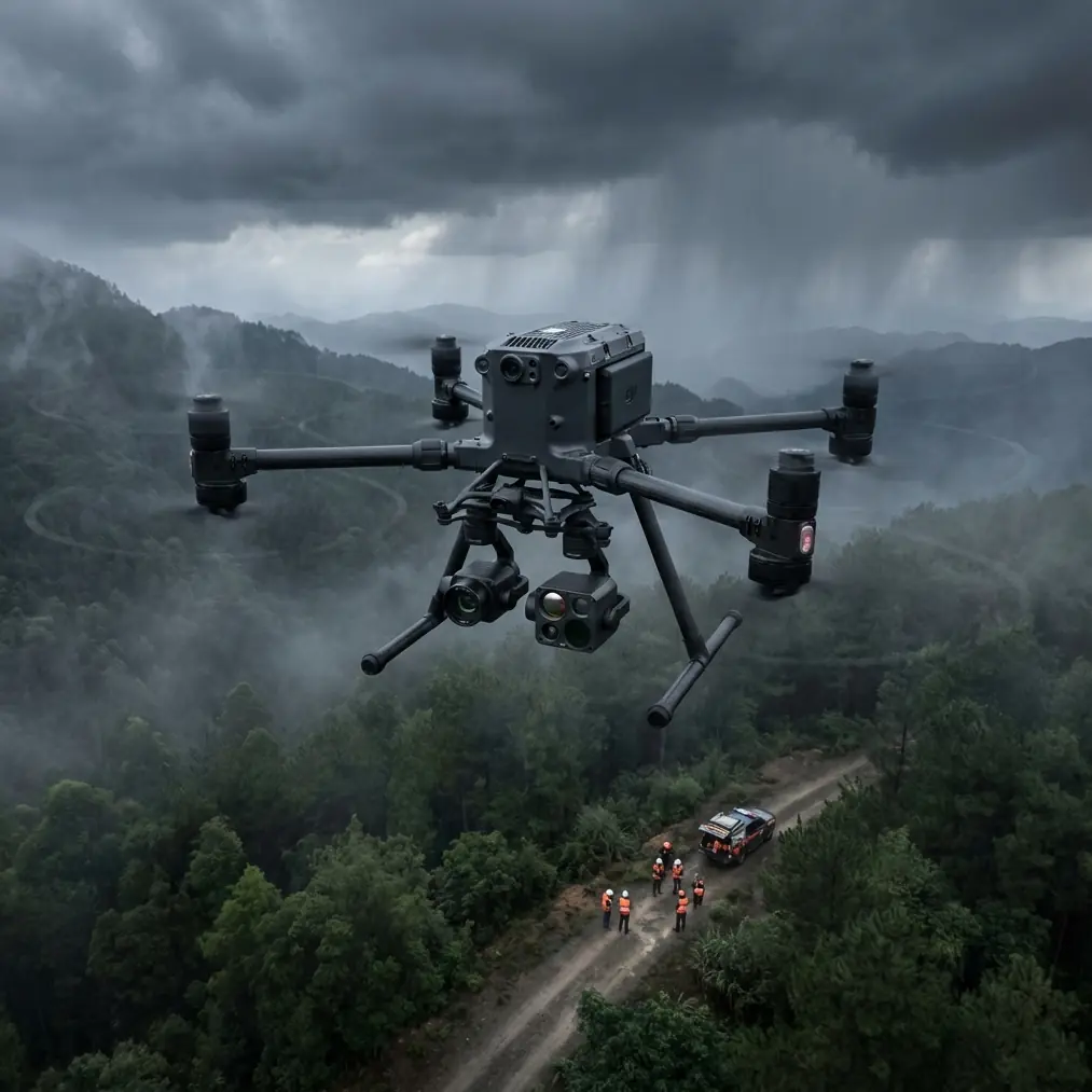
This is where the Matrice 400 becomes interesting.
Not because it is simply a larger aircraft, and not because “more power” is always the answer. The real value shows up when a vineyard team needs to collect reliable visual and thermal data across changing elevation, variable wind, patchy signal environments, and long workdays where every battery cycle affects the schedule. For growers, agronomists, and survey teams working in complex terrain, the Matrice 400 is less about spectacle and more about control.
The field scenario: a hillside vineyard that refuses to behave like a flat map
A recent vineyard documentation workflow illustrates the point well. The site was spread across multiple blocks, each with different row orientation. Some sections ran along a slope. Others cut across it. One lower parcel trapped cold air at dawn, while an upper section dried faster and showed a different canopy response by mid-morning. The client’s goal was not just pretty overhead imagery. They wanted actionable outputs:
- orthomosaics for block-level review
- elevation-aware photogrammetry
- thermal signature comparison between sections
- repeatable flight records for later seasonal analysis
On paper, that sounds straightforward. In practice, steep terrain changes nearly everything. Ground sample consistency becomes harder to maintain. Shadows linger longer in lower rows. Signal quality can shift as the aircraft drops behind terrain. And if you are collecting thermal data, the timing window is narrower than many first-time operators expect.
A Matrice 400 setup helps because it supports disciplined operations rather than forcing compromises. The platform’s transmission reliability, mission planning flexibility, and power management options matter more in a vineyard than a spec sheet alone might suggest.
Why terrain changes the photogrammetry equation
Flat-field mapping is forgiving. Vineyards in complex terrain are not.
Photogrammetry over sloped ground introduces a quiet problem: the aircraft may be maintaining one altitude reference, but the effective distance to the canopy and ground keeps changing. That affects image scale, overlap quality, and the consistency of the dataset. The result can be uneven reconstruction, especially near terraces, retaining features, access roads, and abrupt elevation breaks.
With the Matrice 400, the smart move is to treat terrain as the first variable, not the last. In this case, the workflow began with a terrain-aware flight design supported by GCP placement. Ground control points were not dropped casually near easy road access. They were distributed to reflect elevation variation and edge geometry, because a vineyard on a slope tends to punish lazy control-point strategy.
This is one of those details that separates a usable map from a map that merely looks convincing on a screen.
GCPs matter here for operational significance, not just technical purity. If the grower plans to compare canopy vigor changes over time, or if a manager wants to line up drainage observations with row-specific imagery, spatial consistency has to hold up beyond a single flight. The Matrice 400’s role is to deliver a stable capture platform, but the accuracy comes from combining that stability with disciplined field setup.
Thermal signature work: useful, but only if captured at the right moment
Many vineyard teams ask for thermal imagery because they want to see stress patterns, irrigation irregularities, or drainage effects. That can be valuable. But thermal signature mapping in vineyards is notoriously easy to do badly.
A late morning thermal mission may show you heat. It may not show you meaningful heat.
On this site, thermal capture was scheduled around the temperature transition period when block differences were more visible without the entire landscape flattening into broad daytime warming. The lower sections retained cooler conditions longer, while rows exposed to early sun presented a different thermal profile. That contrast was operationally useful because it helped the client compare microclimate effects across parcels that had been managed similarly but were behaving differently.
The Matrice 400 is well suited to this kind of repeat mission structure because vineyard analysis is rarely one-and-done. You want consistency across dates, not just one dramatic thermal image. The same flight geometry, timing discipline, and battery planning become part of the data quality.
This is also where transmission reliability matters more than many teams realize.
O3 transmission in vineyards: not a luxury feature
In broken terrain, line-of-sight assumptions can become optimistic very quickly. A row crest, tree line, service structure, or a change in launch position can affect the live feed and command link. DJI’s O3 transmission ecosystem is relevant here not as a marketing phrase, but as a practical safeguard for image review, route awareness, and mission confidence while working over segmented vineyard blocks.
When you are trying to verify coverage in a narrow morning thermal window, the ability to maintain a stable link saves time. It also reduces the temptation to rush repositioning or improvise an incomplete second pass. On a complex site, losing confidence in the live connection often creates more workflow inefficiency than the actual flight distance does.
For vineyard operators thinking ahead to larger estates or multi-block surveys, O3 transmission also supports a more scalable operating mindset. Even when a mission remains strictly within visual and regulatory limits, having robust connectivity prepares teams for more advanced operational structures, including BVLOS-oriented planning frameworks where permitted and properly authorized. That matters if the vineyard portfolio expands or if survey work begins to include longer infrastructure corridors such as access roads, irrigation lines, or drainage channels connected to the estate.
AES-256 and why security belongs in agricultural operations
Some teams overlook data security in agriculture because the work feels local and non-sensitive. That assumption is increasingly outdated.
Vineyard imagery can reveal block performance, infrastructure layout, water patterns, equipment movement, and seasonal conditions that a business may not want broadly exposed. If a grower is managing premium fruit on a site where yield variation and disease pressure affect planning, the imagery itself has operational value. AES-256 support matters because it helps protect mission and transmission data in professional workflows where confidentiality is part of the job, even if the mission is purely civilian and agricultural.
That is not abstract. In this case, the client was comparing thermal and RGB outputs alongside block-management notes. They wanted the dataset shared selectively among advisors, not casually circulated. Using an enterprise platform with strong security features aligns with that expectation.
The battery lesson most vineyard teams learn the hard way
Here is the field tip I wish more crews took seriously from the beginning: in steep vineyards, battery planning is not just about total flight time. It is about preserving consistency across flights.
The Matrice 400’s hot-swap batteries are a genuine operational advantage on long survey days. You can keep the aircraft workflow moving without the same level of interruption that forces crews to reset the entire rhythm of the mission. In a vineyard, that matters because lighting and thermal conditions shift fast. If you pause too long between adjacent blocks, your dataset can become harder to compare.
My battery management rule in the field is simple. Do not fly packs down to a heroic minimum just because the aircraft still can. On hillside work, reserve margin is worth more than squeezing out one extra line. Climbing out of a lower contour, holding position in uneven wind, or repositioning after a terrain-shadowed segment can consume energy faster than the mission planner suggested on level-ground assumptions.
The practical tip: pair batteries by age and behavior, label them clearly, and rotate them as committed sets through the day. After each flight, log not only remaining percentage but also how the pair behaved under load during climbs and wind exposure. You will often spot a weak pair before it becomes a schedule problem. With hot-swap capability, there is no reason to introduce inconsistency by mixing battery personalities randomly.
That one habit has saved more vineyard missions than any “maximum endurance” mindset ever has.
Image quality starts before takeoff
On this vineyard project, the most successful outputs came from slowing down the preflight phase. The terrain was divided into logical capture zones rather than forcing a single oversized mission. One zone favored early thermal collection. Another was held for cleaner RGB capture once the sun angle improved. A third required adjusted path design because row orientation and slope created a stronger risk of shadow interference.
This matters because Matrice 400 operators often have enough platform capability to cover a large property efficiently, but efficiency should not be confused with uniformity. Complex vineyards reward selective mission design.
A few practical choices made the difference:
1. Launch position was selected for communication stability, not convenience
The nearest track entrance was not the best launch site. A slightly higher staging point improved signal confidence and reduced terrain masking.
2. GCP placement reflected vertical variation
Control points were spread to anchor both upper and lower sections, improving photogrammetry reliability across elevation changes.
3. Thermal and RGB were treated as different jobs
Trying to collect both under a single timing strategy would have reduced the value of each dataset.
4. Battery swaps were scheduled around data integrity
Hot-swap batteries helped maintain mission flow between adjacent blocks during the most useful capture window.
What the Matrice 400 changes for vineyard teams
The Matrice 400 does not remove the need for experience. It does something better: it gives experienced teams more room to execute correctly.
That shows up in several ways for vineyard operations:
- It supports repeatable mission work where seasonal comparison matters.
- It gives crews stronger transmission confidence in terrain that interrupts simple signal assumptions.
- It fits enterprise-grade data handling where AES-256 security aligns with professional client expectations.
- It reduces downtime pressure through hot-swap battery operations, which is especially useful when thermal timing or light quality creates narrow collection windows.
Those are not isolated features. Together, they shape a workflow that is more dependable in the field.
For vineyards, dependable beats flashy every time.
A note for operators planning BVLOS-style growth
Even if your current vineyard work is conducted under standard visual operating conditions, it is smart to build procedures that can mature into more advanced frameworks later where regulations, approvals, and airspace conditions allow. The Matrice 400 fits that trajectory. Document your launch logic, link behavior, terrain risk points, battery reserve policy, and GCP methodology now. Those habits are what make larger commercial drone programs workable later.
In other words, treat every vineyard mission like a repeatable system, not a one-off flight.
The real takeaway from the hillside rows
The client did not remember the aircraft by payload charts or headline specs. They remembered that the outputs made sense. The thermal signature differences matched what they had observed on the ground. The photogrammetry products aligned properly across difficult terrain. The flight day stayed on schedule because battery changes did not break momentum. And the data package was secure and structured enough to share with the right people only.
That is the standard the Matrice 400 should be judged by.
If you are planning vineyard capture in steep or irregular terrain, the platform’s value lies in how well it supports disciplined data collection under field conditions that punish shortcuts. O3 transmission helps keep the mission stable. AES-256 supports secure professional workflows. Hot-swap batteries protect the timing of the day. And when paired with smart GCP strategy and thoughtful thermal scheduling, the aircraft becomes more than a tool for aerial imaging. It becomes a reliable part of an agricultural decision workflow.
If you want to compare mission design options for a vineyard site with complex contours, this direct WhatsApp line is often the fastest way to discuss the details: https://wa.me/85255379740
Ready for your own Matrice 400? Contact our team for expert consultation.