How to Capture Vineyards in Urban Margins with the Matrice 4
How to Capture Vineyards in Urban Margins with the Matrice 400
META: Practical expert guide to using the Matrice 400 for vineyard imaging in urban environments, covering antenna positioning, photogrammetry, thermal workflows, GCPs, O3 transmission, AES-256 security, hot-swap batteries, and BVLOS planning.
Urban-edge vineyards are awkward places to fly.
They sit between clean agricultural geometry and the signal clutter of the built environment. One row may border a road, another a warehouse roof, another a pocket of homes or utilities. That mix changes everything: radio behavior, launch options, image consistency, safety buffers, and the way you plan each pass for mapping or thermal work.
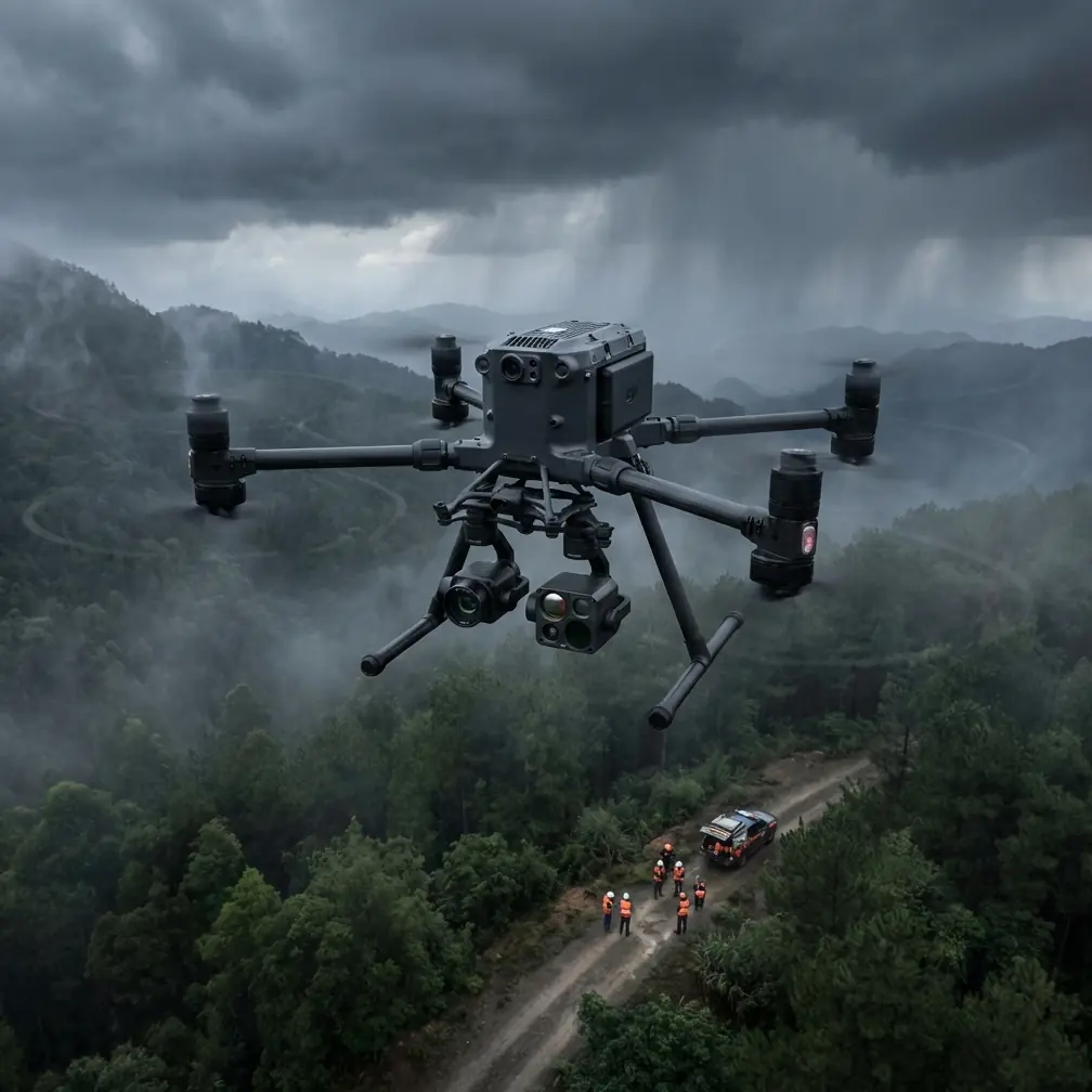
This is where the Matrice 400 makes sense—not as a generic “big enterprise drone,” but as a platform that can stabilize a difficult capture job when the site itself is messy.
If your goal is to document vine vigor, build a photogrammetry model, inspect irrigation patterns with thermal data, or produce repeatable seasonal records, the aircraft is only part of the system. The real result comes from how you set up transmission, power changes, mission geometry, and ground control in a place where agriculture and urban interference overlap.
Below is the field approach I’d use.
Start with the actual objective, not the aircraft
Most vineyard capture mistakes happen before takeoff. Operators say they are “mapping the site,” when in reality they usually need one of four outputs:
- A clean orthomosaic for canopy comparison
- A 3D surface model for terrain, drainage, or row structure
- Thermal signature data to reveal irrigation irregularities, water stress patterns, or edge effects
- Repeatable visual records for management, leasing, compliance, or investor reporting
Those jobs demand different flight behavior.
A photogrammetry mission wants consistency above all else: fixed speed, controlled overlap, even lighting, and reliable GCP placement. A thermal mission cares more about time of day, emissivity behavior, and whether roofs, pavement, and walls near the vineyard are radiating heat into your scene. In urban-adjacent blocks, that matters a lot. A concrete boundary wall warmed all morning can distort the edge rows and trick inexperienced interpreters into calling a vine-health issue where none exists.
The Matrice 400’s value in this setting is less about headline capability and more about operational continuity. If you are covering multiple fragmented parcels or running repeated captures through narrow weather windows, battery workflow and transmission reliability stop being convenience features. They become the difference between one coherent dataset and three half-usable ones.
Why urban vineyards stress the link
Open farmland is forgiving. Urban margins are not.
Buildings reflect and scatter signal. Metal roofs create multipath. Tree lines, poles, and utility corridors interrupt line-of-sight. Add moving traffic and cramped launch positions, and your transmission link can degrade in subtle ways long before the aircraft is visibly far away.
That’s why O3 transmission is not just a specification to recite. In practice, it gives you a stronger foundation for maintaining image downlink quality and control confidence when flying vineyard rows beside urban structures. For inspection-style work and mission supervision, stable downlink quality helps you catch issues in real time: missed rows, shifting exposure, changing shadows, or thermal anomalies at block edges.
Security also matters more than many teams admit. Urban vineyards are often part of premium agricultural operations, research plots, hospitality estates, or branded production sites. If you are collecting agronomic imagery, infrastructure visuals, or thermal datasets, encrypted transmission is not a side note. AES-256 matters because it reduces exposure of operational data moving between aircraft and controller. That is operationally significant when you are documenting proprietary cultivation zones, irrigation layouts, or high-value estate infrastructure.
Antenna positioning advice for maximum range
This is the part most people rush, and it costs them range and link quality.
If you want the best practical transmission performance, do not point the antenna tips directly at the drone. The strongest part of the antenna pattern is typically off the sides, not the ends. In plain field language: present the broad face of the antenna orientation toward the aircraft’s path, and keep that geometry consistent as the mission shifts.
For urban vineyard work, I use four rules:
1. Choose the controller position before you choose the launch point
These are not always the same. The best takeoff area may be a gravel turnout boxed in by trees or walls. The best controller position is where you preserve the clearest line-of-sight over the row direction with minimal obstruction from roofs, utility structures, parked vehicles, and tall trellis-end vegetation.
If needed, launch from one spot and then move to a better observation point only when your procedures and crew setup allow it safely.
2. Face the long axis of the mission
When capturing vineyards, the aircraft often spends most of its time moving in long, parallel legs. Orient yourself and the antennas so the strongest signal geometry supports those long legs, especially the outermost passes where buildings may intrude on the Fresnel zone and reduce signal quality.
3. Gain elevation if the site allows it
A small rise in operator position can do more for transmission quality than many people expect. Even a modest increase in height can reduce near-ground obstructions and improve the consistency of the O3 link over vines, fencing, and parked equipment.
4. Re-aim during side-block transitions
On irregular urban parcels, the drone may shift from one block to another at a different bearing. That is where crews lose range. Re-orient the antennas deliberately during transitions instead of assuming the original stance still works.
If you are planning a difficult site and want a second opinion on antenna geometry or mission layout, you can message our flight team here.
Build the mission around overlap, not just coverage
A vineyard has visual repetition built into it. That repetition is a problem for photogrammetry if your overlap is weak or your altitude is poorly chosen.
Rows can look similar frame to frame, and when urban shadows cut across sections of the block, the reconstruction engine has fewer reliable cues. That is why I advise designing for robust overlap rather than trying to finish in the fewest passes possible. The Matrice 400 gives you the endurance and platform stability to be less aggressive and more precise.
For orthomosaic and 3D work:
- Keep forward and side overlap healthy enough to distinguish repeating vine structures
- Avoid sharp changes in altitude mid-mission unless terrain forces it
- Maintain consistent speed for image spacing
- Watch edge rows near roads and walls, where shadows and mixed surfaces complicate alignment
In this setting, GCPs are not optional if accuracy matters. Urban-edge vineyards often contain abrupt grade changes, retaining features, paved margins, and structures that create false visual confidence in the model. The map may look right while being spatially wrong.
Ground control points anchor the dataset to reality. Their operational value is huge: they improve repeatability across seasonal captures, support trustworthy measurements, and help reconcile imagery with irrigation plans, planting layouts, and survey references. On sites with difficult edges, place GCPs not only in the central block but also near transitions where vine rows meet roads, walls, or building-adjacent surfaces.
Thermal signature work: timing beats sensor obsession
Thermal missions over vineyards near urban areas are often compromised by surrounding materials, not by the aircraft.
Dark roofs, asphalt, masonry, parked vehicles, and HVAC exhaust can all inject heat noise into your dataset. The result is an uneven thermal signature across rows near the site perimeter. If you fly at the wrong time, these boundary effects can dominate the analysis.
With the Matrice 400, the right approach is to use the platform’s mission stability to hit narrower timing windows. Fly when the thermal contrast you care about is most legible, not merely when the crew is available. For irrigation diagnosis, stress pattern review, or drainage-related anomalies, repeatability of timing is often as important as the imagery itself.
Operationally, this means:
- Avoid collecting thermal data after adjacent urban materials have fully heat-soaked unless that specific effect is what you are measuring
- Keep altitude and speed steady to preserve comparability across rows
- Mark suspect edge anomalies for follow-up rather than assuming all hot spots indicate crop issues
- Cross-check thermal observations with visible imagery and site context
A good thermal workflow in a vineyard is rarely “fly once and decide.” It is “capture, compare, verify.”
Hot-swap batteries are more valuable than they sound
Battery changes break momentum. On fragmented vineyard sites, they also break consistency.
The advantage of hot-swap batteries is not just reducing downtime. It helps preserve the rhythm of the operation when light, shadow, and thermal conditions are changing. If you are running back-to-back missions across multiple blocks, hot-swapping lets you keep the aircraft workflow moving while reducing the dead time that can force you to restart under materially different conditions.
That matters in three practical ways:
Lighting continuity
Photogrammetry outputs improve when the scene remains visually consistent. Delayed relaunches can introduce shadow drift that makes stitching harder.Thermal timing discipline
A narrow useful window can close quickly, especially at urban edges where hard surfaces warm fast.Crew focus
Shorter interruptions usually mean fewer setup mistakes, less rushed decision-making, and better mission continuity.
For recurring vineyard documentation, that continuity becomes part of your data quality.
BVLOS planning changes the way large estates are captured
On very large properties or separated vineyard parcels, BVLOS planning can reshape the workflow completely—where regulations, approvals, and operator qualifications allow it. I’m not talking about stretching boundaries casually. I’m talking about structured planning for legal, risk-managed operations.
For commercial agriculture, BVLOS significance is straightforward: fewer repositioning events, more efficient corridor-style coverage, and better consistency across long blocks that are otherwise inconvenient to capture from one visual position. On urban-fringe sites, though, the planning burden is higher because airspace complexity, obstacles, and third-party exposure all increase.
That means your route design should account for:
- Clear geofenced boundaries between vine blocks and adjacent built areas
- Conservative altitude choices around obstacles
- Defined contingency points for signal degradation
- Predictable transitions if the terrain or building profile changes
The Matrice 400 is well suited to this type of structured mission planning, but the aircraft never substitutes for the operational discipline behind BVLOS.
A practical capture sequence for urban vineyards
If I were running a standard daytime visual-plus-thermal job on an urban-edge vineyard, my sequence would look like this:
1. Walk the perimeter
Confirm obstructions, reflective surfaces, utility lines, road activity, and the best controller position.
2. Set GCPs where they solve real problems
Use them at corners, elevation changes, and edge zones where vineyard meets urban surfaces.
3. Establish antenna orientation before launch
Stand where the mission’s longest legs have the cleanest line-of-sight. Rehearse likely re-aim points.
4. Run visual photogrammetry first if light is stable
Capture the orthomosaic or 3D dataset while shadows are manageable and the site is visually consistent.
5. Transition quickly using hot-swap batteries
Preserve timing rather than letting the mission reset drift your conditions.
6. Fly the thermal mission in the intended comparison window
Do not casually “grab thermal too” after the fact. Thermal needs its own timing logic.
7. Review edge rows before leaving site
Urban-adjacent rows are where hidden data problems tend to show up first.
The real payoff
The Matrice 400 is at its best when the site is complicated enough to expose weak planning.
Urban vineyards do exactly that. They punish poor antenna positioning, sloppy overlap choices, lazy battery management, and thermal flights done at the wrong hour. But when the operation is planned properly, the aircraft supports a workflow that is repeatable, secure, and efficient.
Two details stand out operationally.
First, O3 transmission is genuinely useful in these mixed environments because it helps sustain link reliability where structures and reflective surfaces would otherwise undermine confidence during long row captures. Second, hot-swap batteries help preserve capture continuity, which directly improves data consistency in both photogrammetry and thermal missions. Add AES-256 transmission security and disciplined GCP placement, and you have a serious professional workflow rather than a simple drone flight.
That is the difference between pretty vineyard imagery and decision-grade data.
Ready for your own Matrice 400? Contact our team for expert consultation.