Matrice 400 in Mountain Vineyards: A High
Matrice 400 in Mountain Vineyards: A High-Altitude Photogrammetry Case Study
META: A field-based Matrice 400 case study on capturing high-altitude vineyards, covering photogrammetry workflow, weather shifts, multi-angle image collection, 3D modeling, GCP strategy, and why stable airborne data matters.
By Dr. Lisa Wang, Specialist
The interesting part of vineyard drone work is rarely the flight itself. It is the chain of consequences that starts in the air and ends on a grower’s screen: canopy maps, slope models, drainage clues, missing rows, stressed blocks, and 3D context that makes those findings usable instead of abstract.
That chain gets harder in high-altitude vineyards.
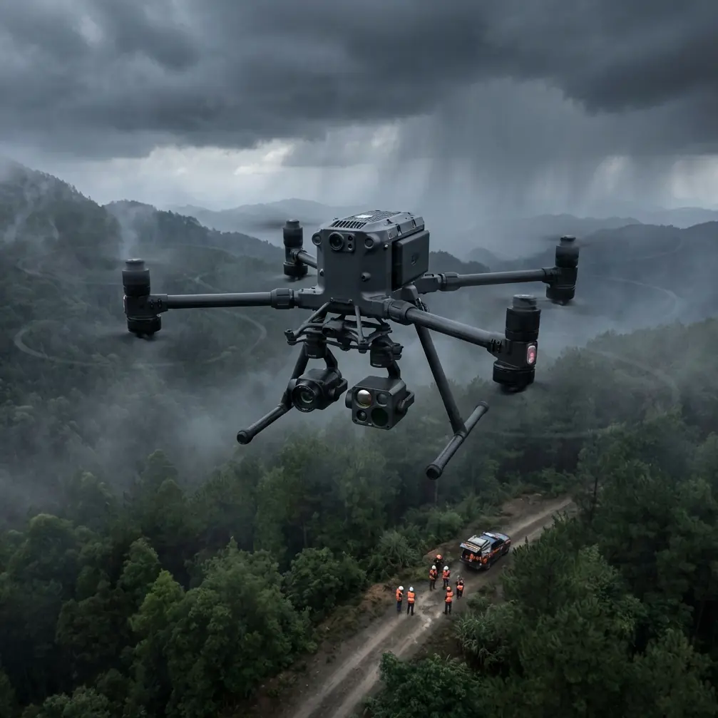
Steep terrain compresses your margin for error. Wind behaves differently along ridgelines than it does over a flat field. Light changes fast. A mission that looks routine at takeoff can become unstable by the time the aircraft reaches the upper terraces. For this case study, the focus is the Matrice 400 operating in exactly that sort of environment: a commercial vineyard spread across elevated slopes where the goal was not just pretty imagery, but reliable photogrammetric output and thermal interpretation that the farm team could trust.
What matters most here is not a spec-sheet recital. It is how the aircraft’s flight behavior, transmission stability, battery handling, and data pipeline work together when the weather stops cooperating mid-mission.
The mission brief: vineyards, altitude, and a mixed deliverable set
The assignment was straightforward on paper. Capture a large vineyard at elevation and produce a dataset suitable for both photogrammetry and thermal review. The winemaking team wanted more than orthomosaics. They needed terrain-aware context for vine vigor patterns, road access planning between blocks, and a cleaner view of where water movement across the slope might be influencing plant stress.
In practical terms, that meant two things.
First, the image capture had to support a strong 3D reconstruction, not just a top-down map. Second, the flight had to remain efficient enough to complete while mountain weather was still within tolerance. Anyone who has mapped vineyards on terraced ground knows that delayed battery swaps, weak signal at the far side of a ridge, or uneven overlap can compromise the whole project long before software enters the picture.
This is where the Matrice 400 becomes relevant. Not as a generic “enterprise drone,” but as a platform designed for jobs where a broken data chain is expensive.
Why image geometry matters more in vineyards than many teams expect
High-altitude vineyards are deceptive. From a distance, rows appear regular and easy to map. But vines are not flat targets, and terraced landscapes introduce occlusion, shadow, and rapid elevation change. If your data collection is built around simplistic nadir-only assumptions, your downstream 3D model will often miss the very details growers care about: embankment shape, retaining edges, service track deformation, localized canopy gaps, and the geometry of block boundaries.
The reference material behind this article points to a crucial truth in photogrammetry: high-quality 3D reconstruction depends on a set of digital photographs of a static subject captured from different angles. That is not a theoretical software requirement. It is operational guidance.
Bentley ContextCapture, cited in the reference documents, relies on exactly that kind of multi-angle image input. The same source also notes that the system can produce high-resolution textured triangular mesh models in minutes or hours, depending on dataset size, and can reproduce the subject’s true color, geometry, and structural detail with a high degree of fidelity. For vineyard work, that means the output can become more than a map. It can become a spatial model useful for field logistics, replant planning, erosion review, and communication across viticulture and operations teams.
With the Matrice 400, we structured the mission around that requirement from the beginning. We did not fly a single-pass, purely top-down pattern and hope software would fill the gaps. We built overlap and viewing diversity into the job because the software can only solve from the data it receives.
The mid-flight weather shift
The takeoff window was clean. Light wind, thin cloud, good visibility over the lower blocks. By the time the aircraft had climbed toward the upper vineyard sections, the conditions changed. A lateral wind line developed across the slope, and a moving bank of cloud altered both illumination and contrast over alternating rows.
This is the kind of transition that exposes weak platforms and weak planning at the same time.
A lesser workflow tends to break in one of three places:
- the aircraft struggles to hold a precise path over changing terrain,
- the transmission link becomes less trustworthy once the aircraft crosses uneven topography,
- or the team rushes the capture to beat the weather and degrades the overlap pattern.
We avoided all three.
The Matrice 400 held the mission profile well enough to preserve capture consistency while conditions deteriorated. The O3 transmission link mattered here for a simple reason: in broken terrain, maintaining dependable command and video confidence is not a luxury. It changes decision quality. When the aircraft moved toward the upper rows and partial slope shielding began to affect line-of-sight geometry, stable transmission gave us time to assess whether to continue the leg, modify altitude, or pivot into a shortened collection sequence without improvising blindly.
For clients operating in sectors where data security standards matter, AES-256 support is also part of the conversation. In agriculture, that may sound excessive until you consider how often vineyard imagery, terrain models, treatment planning, and infrastructure layouts move between owners, consultants, and processing teams. Security is not the headline of a mapping mission, but it should be part of the workflow architecture.
Hot-swap batteries changed the risk profile
In mountain vineyard operations, battery management is never just about endurance. It is about continuity.
The upper launch area was serviceable but tight, bordered by uneven ground and equipment traffic. That made every battery event a potential source of delay. The advantage of hot-swap batteries is not only speed. It is the ability to keep a mission rhythm intact when the environment is already introducing enough variability. In this case, the weather shift reduced our tolerance for downtime. We needed to keep the collection sequence moving while preserving consistent light conditions across adjacent blocks as much as possible.
That is where hot-swap capability earns its place in the workflow. Faster turnaround means fewer gaps between sorties, less chance of having one half of a vineyard captured under one sky condition and the other half under a different one, and less pressure on the crew to skip a planned oblique segment just to save time.
For photogrammetry, continuity matters. Image sets captured too far apart in changing light can still process, but the results may require more cleanup and can reduce the visual coherence of textured models. In a vineyard, where row definition and canopy edges need to remain interpretable, that matters.
Ground control and software are only as good as the airborne data
There is a familiar mistake in drone mapping circles: overestimating what processing software can recover from mediocre capture.
The reference documents mention several processing paths, including AT.Pips.Cloud, which is designed to use networked multi-machine and multi-core hardware resources to efficiently generate high-precision model tie points, especially for low-altitude aerial triangulation. That point deserves attention. Strong aerial triangulation does not happen by magic. It depends on image quality, overlap discipline, and enough geometric diversity for the software to identify and strengthen connections across the block.
The same principle applies if the team uses SkyPhoto-Super or ContextCapture in a production environment. Advanced software helps. It does not rescue careless fieldwork.
For this vineyard mission, we used a GCP strategy targeted at the terrain breaks rather than distributing points in a simplistic grid. On sloped agricultural land, GCP placement has to reflect the geometry of the site. Terrace edges, road junctions, and elevation transitions often deserve more attention than broad uniform zones. The reason is straightforward: those are the locations where minor geospatial drift becomes operationally visible. If a grower compares your model against actual access paths, drainage cuts, or planting edges and sees positional mismatch there, confidence in the entire dataset drops.
The Matrice 400’s role in this is indirect but decisive. A stable aircraft with consistent image capture supports stronger tie point generation, cleaner block alignment, and better use of GCPs. Processing software amplifies data quality; it does not invent it.
Thermal signature in vineyards is useful only when spatial context is reliable
Thermal mapping in vineyards is often discussed as if the sensor alone does the work. It does not.
A thermal signature becomes valuable when it can be interpreted in relation to row geometry, terrain exposure, access lanes, and irrigation context. In a high-altitude site, two warm zones may look similar in a thermal layer but mean very different things on the ground. One may reflect real water stress. Another may come from slope orientation, rock exposure, or airflow differences near a ridge.
That is why pairing thermal observations with a photogrammetry-ready flight plan matters. The 3D reconstruction and high-resolution surface model help separate plant issues from terrain-driven effects. When the reconstruction is solid, the agronomy team can examine anomalies in context rather than chasing every warm patch as if it were a crop-health emergency.
This is one of the strongest arguments for using a workflow built around multi-angle image capture and robust triangulation. It improves interpretation, not just aesthetics.
Why BVLOS discussions matter even when the flight stays conservative
The vineyard in this case did not require a reckless operational envelope. But the growing interest in BVLOS capability is still relevant in mountainous agriculture. Large, fragmented estates and remote slope blocks create pressure for longer, more efficient coverage. That said, responsible operators know BVLOS is not a feature toggle. It sits inside a regulatory, procedural, and risk-management framework.
So why mention it here?
Because the Matrice 400 belongs in conversations about scaling agricultural operations across larger and more complex properties. Even when a mission is conducted conservatively within standard visual procedures, the platform characteristics that support more advanced operations—stable link performance, efficient battery workflow, and predictable mission handling—also improve ordinary field jobs. The vineyard team benefits from that maturity even if the sortie itself is modest.
The less glamorous detail that actually matters: materials and airframe confidence
One of the stranger but useful clues in the reference set comes from the aircraft materials document, which lists suppliers and specifications associated with aerospace composite materials, including names such as Hexcel Corporation at 10 Trevamo Road, Livermore, California 94550, Ferro Composites at 5915 Rodeo Road, Los Angeles, CA 90016, and multiple BMS material references like BMS8-278 and BMS8-226.
Why bring up a materials table in a vineyard article?
Because field operators often talk about payloads and software while forgetting that high-altitude agricultural work is physically demanding on the airframe. Temperature swings, repeated climbs, transport over rough access roads, and wind exposure all place stress on the platform. Composite material ecosystems are part of the deeper engineering culture behind reliable aircraft design. No, a vineyard manager does not need to memorize material designations. But for professionals choosing a platform for frequent slope work, airframe integrity is not an abstract issue. It influences long-term consistency, maintenance intervals, and confidence when the aircraft is asked to perform in less forgiving terrain.
That background does not replace field validation, but it reminds us that robust aerial performance begins far below the payload mount.
What the client actually received
By the end of the mission, the client had more than a visual survey. They received a dataset built for:
- orthomosaic generation for block-level planning,
- 3D textured modeling of vineyard terrain and access features,
- thermal review linked to real geometric context,
- and repeatable baseline capture for future seasonal comparison.
The operational significance of the software references becomes clear here. A platform like ContextCapture can turn multi-angle photo sets into detailed textured triangle meshes that reflect real color and structure. A triangulation engine like AT.Pips.Cloud can leverage multi-machine, multi-core computing to strengthen aerial triangulation efficiency for low-altitude image blocks. Those are not software trivia points. They define how quickly raw flights become usable vineyard intelligence.
If your team is planning similar work and wants to discuss flight design, terrain-aware overlap, or processing choices, you can reach us directly on WhatsApp for vineyard mapping coordination.
The broader lesson from this Matrice 400 vineyard job
The real test of a drone platform is not whether it performs on a calm day over a flat demonstration field. It is whether it preserves data quality when terrain, weather, and operational timing all start leaning against the mission.
On this high-altitude vineyard project, the Matrice 400 proved valuable because it supported the entire workflow, not just the airborne portion. Stable transmission helped during a changing weather window. Hot-swap batteries preserved capture continuity. A disciplined image plan aligned well with the known requirements of photogrammetric and 3D modeling software that depends on multi-angle photography. Thermal interpretation improved because it was tied to stronger spatial context. And the job finished with output that a commercial vineyard could actually use.
That is the difference between flying a site and understanding it.
Ready for your own Matrice 400? Contact our team for expert consultation.