Capturing Wildlife at High Altitude With Matrice 400
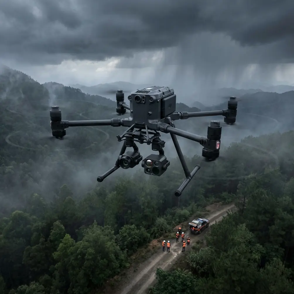
Capturing Wildlife at High Altitude With Matrice 400: What Actually Matters in the Field
META: A field-focused look at using Matrice 400 for high-altitude wildlife work, with practical insight on thermal signature capture, transmission reliability, temperature effects, and mission planning.
High-altitude wildlife work exposes every weak assumption in a drone workflow.
On paper, a mission may look simple: launch, gain elevation, locate animals, collect imagery, return. In reality, mountain air, sharp temperature swings, long sightlines, and fragile subjects change the equation. This is where the Matrice 400 becomes interesting—not as a generic “powerful drone,” but as a platform that can be shaped into a more disciplined observation tool when operators understand the engineering logic behind it.
I approach this from the same angle I use in field reviews and training: the aircraft matters, but the mission architecture matters more. If your goal is to capture wildlife at altitude without compromising image quality, positional confidence, or animal welfare, the Matrice 400 has to be treated as part of a system that includes payload choice, thermal behavior, data security, transmission resilience, and battery strategy.
The real problem with high-altitude wildlife missions
Wildlife surveys in alpine or subalpine terrain are usually constrained by four things:
- Distance from launch point
- Cold-related performance drift
- Difficulty separating animals from background terrain
- Limited time on station when conditions change fast
That fourth point is underrated. Conditions at elevation can shift within minutes. Light angle changes. Wind accelerates along ridgelines. Animals move between exposed ground and canopy or rock shadow. If the aircraft cannot hold a clean data collection pattern—or if the crew has to break the mission because of battery management friction—you lose continuity.
The Matrice 400 is attractive in this context because it supports a more modular workflow. Not just visual capture, but layered observation: thermal signature detection for finding animals, followed by optical confirmation, and in some projects, photogrammetry for habitat mapping or movement corridor analysis.
That sounds straightforward until temperature starts interfering with everything from materials to measurements.
Why temperature correction is not an academic detail
One of the more useful engineering references in the provided material comes from a standard aircraft design handbook discussing dimensional correction caused by thermal expansion. The table gives temperature-based correction values and shows just how much dimensions can shift with material expansion coefficients. In one Fahrenheit-based section, for example, a value at 88°F corresponds to correction figures such as 20, 40, 60, 80, 100 and up to 600 in the table’s listed scale. Another Celsius-based section shows correction values reaching -570 under certain combinations of temperature and thermal expansion coefficient.
Most drone operators will never quote those figures in the field. They should still understand the operational meaning.
At high altitude, especially when launching in a cold valley and climbing toward sunlit rock faces, you’re dealing with temperature gradients that affect more than batteries. They affect calibration consistency, mounting interfaces, sensor housing behavior, and, at the precision end, mapping confidence. If you are using the Matrice 400 for wildlife documentation tied to habitat analysis, that means your photogrammetry outputs and GCP-referenced measurements should never be treated as temperature-neutral by default.
This matters in two practical ways:
- Payload alignment can drift subtly across temperature swings. Even small physical changes in brackets, rails, or third-party mounts can influence repeatability.
- Habitat mapping for research-grade outputs needs tighter QC. If teams are producing orthomosaics or terrain models to compare seasonal wildlife movement, they should validate against GCPs rather than assuming airborne capture alone is enough.
The drone world often talks about image resolution while ignoring metrological discipline. In wildlife work, that is a mistake. If you are comparing denning zones, herd pathways, or nesting margins over time, the geometry has to be defensible.
Thermal signature is often the first clue, not the final answer
For high-altitude wildlife capture, thermal signature detection is one of the most useful capabilities you can add to a Matrice 400 setup. It helps in low-contrast environments where animals visually blend into scree, snow shadow, sparse scrub, or broken forest edges.
But thermal should not be treated as magic.
At elevation, rock faces may hold heat unevenly. Early morning and late afternoon can generate misleading contrast. Snow patches can sharpen subject detection in one area while flattening it in another. A warm-bodied animal against sun-touched stone may not pop as strongly as you expect.
That’s why the best Matrice 400 wildlife workflow is usually thermal for detection, visible-spectrum zoom for confirmation, and then mapping only where ecological or management goals justify it.
A strong third-party accessory can make a noticeable difference here. In one mountain survey configuration I’ve recommended, a third-party high-gain directional antenna kit significantly improved link consistency during ridge-obstructed observation windows. This did not “extend the mission” in a simplistic sense. What it really did was reduce transmission instability when the aircraft was working across broken topography, which gave the crew more confidence in maintaining steady observation passes instead of repositioning unnecessarily.
That kind of upgrade is often more valuable than chasing one more sensor feature.
O3 transmission is only as useful as your terrain logic
The reference data also includes a second useful concept from civil aircraft market analysis: a framework where experts quantified 7 competition factors and used 0–100% scoring to evaluate aircraft against target-market needs. One excerpt shows average factor scores such as 0.924, 0.964, 0.947, 0.955, 0.966, 0.876, and 0.955.
Those numbers are not about the Matrice 400, but the method is highly relevant.
Too many drone procurement decisions are based on broad reputation instead of weighted mission factors. For wildlife teams operating at altitude, I would adapt that same scoring logic to evaluate the Matrice 400 against actual field priorities:
- transmission reliability across terrain
- payload switching speed
- battery turnover efficiency
- thermal detection usefulness
- optical confirmation quality
- geospatial repeatability
- data protection
This is where O3 transmission earns its place. In mountain environments, link quality is not just about distance. It is about how the system behaves when terrain introduces intermittent masking, changing angles, and variable multipath effects. A drone can have excellent nominal transmission specs and still frustrate a wildlife team if the signal path is repeatedly compromised by ridgelines or abrupt elevation changes.
Operationally, that means pilots should stop thinking of transmission as a fixed performance number and start thinking of it as a route-planning variable. Launch point placement, antenna orientation, flight corridor selection, and observation orbit geometry all shape whether O3 performs cleanly enough for reliable wildlife documentation.
Hot-swap batteries change the tempo of observation
If you’ve ever tracked wildlife behavior around narrow feeding windows or migration bottlenecks, you know the enemy is often downtime rather than range.
This is why hot-swap batteries matter on a platform like the Matrice 400. They are not just a convenience feature for enterprise checklists. In wildlife operations, they can preserve continuity. The crew can keep the aircraft ready between sorties with less interruption, which is especially useful when the goal is to monitor recurring movement through a pass, cliff zone, or alpine meadow.
At high altitude, battery planning should be conservative for another reason: thermal conditions can narrow your usable margin faster than expected. A battery that looks acceptable on the ground may behave differently after exposure to cold airflow and power demand during climb segments.
A disciplined workflow I recommend:
- pre-warm and stage packs intelligently
- plan shorter initial reconnaissance legs
- reserve enough power for descent against headwind, not just return-to-home distance
- use hot-swap capability to keep observation cycles tight when subjects are active
For wildlife researchers, that can mean capturing the decisive sequence rather than the empty terrain five minutes later.
AES-256 is not just for corporate policy
Wildlife data is often more sensitive than teams first assume.
If the Matrice 400 mission involves endangered species, nesting sites, breeding colonies, or protected migration paths, the location data itself can become sensitive. Even when the operation is purely civilian and conservation-focused, geotagged imagery can expose habitats to disturbance if not handled properly.
That is where AES-256 matters operationally. It adds a stronger layer of protection to mission data and transmission workflows, helping organizations manage risk around ecological datasets. For NGOs, reserve managers, consultants, and university teams, this is not a technical footnote. It is part of responsible field practice.
I would go further: if your wildlife program uses shared crews, temporary field laptops, or cross-border research partners, encrypted handling should be paired with stricter file naming, access control, and export routines. Strong crypto does not fix weak procedure, but it raises the floor.
BVLOS changes what is possible, but also what must be proven
For large habitat corridors and highland survey zones, BVLOS can dramatically improve coverage efficiency. On the Matrice 400, this opens the door to wider-area ecological missions where direct proximity to every observation point is unrealistic.
Still, wildlife teams should be careful not to frame BVLOS as a blanket answer. In mountain settings, BVLOS only becomes truly useful when three things are aligned:
- terrain-informed route design
- dependable command and video link behavior
- a payload stack matched to the ecological question
If your purpose is simply locating animals in a known basin, a visual observer network and shorter line-of-sight hops may produce cleaner data with less administrative complexity. If the objective is repeated corridor monitoring over broad, inaccessible ground, then BVLOS becomes far more compelling.
The Matrice 400’s value here is less about “flying farther” than about supporting a professional operating model with the right redundancy, payload discipline, and data chain.
A practical solution stack for Matrice 400 wildlife capture
For high-altitude wildlife projects, I would structure the Matrice 400 around a layered solution:
1. Detection layer
Use thermal to identify likely animals or clusters where visible imagery alone would miss them.
2. Confirmation layer
Shift to optical zoom or high-resolution visual capture to verify species, count individuals where possible, and document behavior without pushing too close.
3. Mapping layer
When habitat analysis matters, use photogrammetry with well-placed GCPs to maintain spatial confidence rather than relying solely on airborne geotags.
4. Continuity layer
Exploit hot-swap batteries to reduce downtime during active wildlife windows.
5. Communications layer
Plan around O3 transmission as a terrain-dependent resource, potentially supported by a third-party directional antenna accessory where lawful and appropriate.
6. Security layer
Protect ecological data with AES-256 and disciplined file handling.
That is the difference between owning a capable aircraft and running a capable wildlife program.
The field lesson most crews learn late
The Matrice 400 is at its best in wildlife work when operators resist the urge to treat it like a camera in the sky.
It is really a data-collection platform working inside a changing thermal, geometric, and communications environment. The aircraft design reference on temperature correction reminds us that physical systems shift with heat and cold. The aircraft market-analysis reference reminds us that serious platform evaluation comes from weighted factors, not hype. Put those two ideas together, and a smarter Matrice 400 workflow emerges: evaluate what matters, then control what drifts.
For teams preparing a high-altitude wildlife program, that means setting mission criteria before launch day. Define whether the main success metric is detection rate, species confirmation, repeatable mapping, or temporal continuity. Then configure the aircraft and crew around that priority.
If you’re comparing payload options, accessory compatibility, or mountain mission setup details, it often helps to discuss the exact terrain profile and observation goal first—this field message channel is a practical starting point: talk through your Matrice 400 wildlife setup.
High-altitude wildlife capture rewards patience, restraint, and engineering awareness. The Matrice 400 can serve that mission very well, but only when the operator pays attention to the details that actually survive contact with the mountain.
Ready for your own Matrice 400? Contact our team for expert consultation.