Matrice 400 on the Coast: A Field Case Study in Extreme
Matrice 400 on the Coast: A Field Case Study in Extreme Temperatures, Salt Exposure, and Mission Reliability
META: Expert case study on using the DJI Matrice 400 for coastline operations in extreme temperatures, with practical guidance on thermal workflows, cleaning, battery strategy, transmission security, and BVLOS readiness.
Coastline work exposes an aircraft to a punishing mix of variables that rarely show up together anywhere else. Salt mist creeps into connectors. Wind shifts without warning. Surface temperatures swing hard between dawn fog and full-sun glare off rock, concrete, and water. If you are tasked with delivering along the coast in those conditions, the platform matters, but so does the way you prepare it. That is where the Matrice 400 becomes interesting—not as a brochure subject, but as a working aircraft in an environment that punishes weak habits.
This case study is built around a practical scenario: a coastal delivery and survey team using the Matrice 400 in extreme temperatures while maintaining mission continuity, image integrity, and operational safety. The aircraft is only part of the story. The rest comes down to cleaning discipline, payload logic, transmission resilience, and how you manage energy when a landing window is narrow.
The first lesson is surprisingly mundane: pre-flight cleaning is a safety feature.
On inland jobs, crews sometimes rush through wipe-downs because dust is visible and easy to judge. On the coast, contamination is subtler and more dangerous. A light salt film on downward sensors, landing optics, or exposed contact points can degrade the very systems pilots rely on for stable takeoff, obstacle awareness, and consistent return procedures. Before our team powered up the Matrice 400 for a cold-morning shoreline run, the checklist started with a soft, non-abrasive clean of the vision system covers, payload glass, battery interfaces, and airframe seams where salt residue tends to collect after the previous day’s flights.
That step was not cosmetic. It directly affected trust in the aircraft’s situational awareness and data capture. If the mission calls for thermal work, even a faint smear on the sensor window can distort how a thermal signature appears against reflective water or sun-heated stone. Along the coast, a false thermal read is not a small inconvenience. It can send a team toward the wrong heat source, miss a person or vessel in distress, or compromise inspection findings on infrastructure exposed to marine conditions.
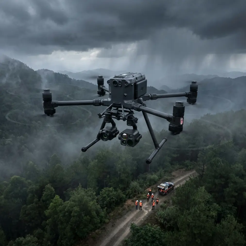
The Matrice 400 fits this kind of work because it supports a multi-layered mission profile rather than forcing operators into a single-purpose setup. In a coastal delivery scenario, one flight may involve route verification over uneven cliff edges, thermal observation of assets or people, and image capture for photogrammetry to update shoreline changes after storms. That combination is where the aircraft earns its keep. You are not just flying from point A to point B; you are flying through an operating picture that changes by the minute.
For that reason, the team structured every sortie around three mission questions.
First: what is the thermal environment doing?
Second: what does the terrain model need to capture today?
Third: what can interrupt command, control, or battery continuity before the aircraft returns?
The thermal piece mattered because coastlines create deceptive contrast. Wet sand cools differently than dry berms. Black rock stores heat longer than surrounding surfaces. Metal structures near harbors often remain visible on thermal views well after ambient temperatures drop. On the Matrice 400, that means thermal payload work is not just about seeing heat; it is about interpreting changing heat behavior against reflective backgrounds. An experienced operator learns quickly that a thermal signature above water can stretch, fade, or blend depending on angle, air temperature, and time of day. That is why our team scheduled heat-sensitive passes at stable periods rather than during the worst thermal volatility around midday.
Photogrammetry required a very different mindset. Coastal mapping has a habit of punishing lazy assumptions because everything moves: waves reshape edges, tides shift boundaries, and soft terrain alters your visual reference points. The Matrice 400’s role here was to hold a disciplined capture pattern while the crew supported the mission with GCP placement where practical. Ground control points remain one of the most useful tools for coastal accuracy because shorelines are full of visual ambiguity. Without solid GCP strategy, repeated surveys may look consistent enough to pass a quick glance while still drifting enough to weaken change detection over time.
That matters operationally. If you are delivering into remote coastal zones, the map is not just a nice deliverable for a client report. It can affect route planning, safe approach corridors, and whether a temporary landing or handoff zone remains usable after weather events. In this case, the Matrice 400 was used to support both immediate delivery operations and the broader geospatial model the team depended on for recurring missions. One aircraft, two layers of value.
Transmission reliability was the next pressure point, and this is where O3 transmission became more than a spec-sheet talking point. Coastal corridors often create odd radio behavior due to terrain cuts, built infrastructure, and signal reflections from water. In practice, a stable link is not simply about range. It is about maintaining command confidence when the aircraft moves past bluffs, around concrete structures, or across bright, reflective marine surfaces that can complicate signal behavior. For teams operating near the edge of visual practicality—or preparing procedures aligned with BVLOS frameworks—that continuity changes the risk calculation.
A strong link also supports a less discussed part of professional operations: decision speed. When live video and telemetry remain trustworthy, the pilot and visual team can make cleaner calls on reroutes, delivery confirmation, and weather-triggered aborts. That is especially valuable when winds on the waterline differ from winds just 60 or 80 meters inland. With the Matrice 400, the communications layer is not separate from safety. It is safety.
Security also enters the picture faster than many operators expect. Coastal deliveries are often tied to infrastructure, utilities, maritime support, or sensitive logistics. In those settings, AES-256 encryption is not an abstract enterprise checkbox. It directly affects whether mission data and control links meet internal security expectations. If your aircraft is capturing thermal imagery of restricted areas, asset layouts, or transport nodes, the question is no longer whether security matters but whether the aircraft stack supports a professional chain of custody for mission information.
Energy management was the operational hinge for this case study. Extreme temperatures have a way of exposing every weak battery habit a team has. In cold coastal mornings, battery performance can feel fine right up until load and wind reveal otherwise. In heat, turnaround speed becomes its own risk because crews tend to push schedules while packs warm faster on deck or in vehicles. The Matrice 400’s hot-swap batteries changed the day more than any flashy feature could. The team was able to rotate power quickly between missions without wasting the narrow windows when wind and visibility aligned.
That matters because coastal operations rarely reward delay. A ten-minute pause can mean tide shift, stronger gusts, glare conditions that ruin your imaging pass, or a vessel movement that changes the mission geometry entirely. Hot-swapping reduced those dead zones and kept the aircraft in rotation while still giving the crew room to inspect pack condition, confirm connector cleanliness, and verify temperature-related readiness before relaunch.
There was a second benefit: safer workflow discipline. Because the Matrice 400 made power transitions more efficient, the team was less tempted to shortcut inspections. That is not a small point. Good systems reduce the incentive for bad decisions. When crews know they can restore readiness fast, they are more likely to stick to the cleaning and verification steps that keep sensors accurate and battery interfaces dependable in a salt-heavy environment.
One moment from the operation stood out. After a morning run along a rocky delivery corridor, the team noticed faint residue building near the sensor surfaces and landing gear area—barely visible, easy to ignore. They stopped the cycle, cleaned the aircraft before the next launch, and rechecked the thermal feed. The image stabilized noticeably against the shoreline background. Had they skipped that step, they likely would have completed the sortie anyway, but with less confidence in edge detail and hotspot separation. That is the difference between recreational flying culture and professional coastal operations: you treat small contamination as a mission variable, not an aesthetic flaw.
The BVLOS question naturally hovered over the whole workflow. Not every team or jurisdiction will run these missions beyond visual line of sight, but the coastline is one of the clearest examples of why operators keep moving in that direction. Routes are often linear, remote, and time-sensitive. Access by vehicle can be slow or impossible. A platform like the Matrice 400 becomes far more useful when its transmission, awareness systems, data security, and battery architecture support a credible BVLOS planning model. Even when the day’s mission remains within existing visual constraints, the aircraft’s operational logic should be built with that future in mind.
What does that mean in practical terms? It means your procedures need to mature alongside the hardware. You need route segmentation, weather thresholds tied to real terrain effects, communication contingencies, and a documented cleaning routine that treats salt as a flight risk. You also need to know when thermal is useful and when it becomes misleading, when GCP deployment is worth the extra setup time, and when delivery timing should yield to image quality or signal confidence. The aircraft can handle a lot. The operator still carries the burden of judgment.
For teams trying to build that kind of coastal workflow, it helps to compare checklists and field habits with people who have done it under pressure. A quick way to discuss route design, payload planning, or battery rotation strategy is to message a field specialist here.
The larger takeaway from this Matrice 400 case study is simple: coastal delivery in extreme temperatures is not a test of raw aircraft power alone. It is a test of systems thinking. The Matrice 400 stands out because it supports that mindset across several fronts at once. Thermal capability helps crews interpret conditions that are not obvious in visible light. Photogrammetry workflows backed by GCP discipline improve the accuracy of repeat missions and route planning. O3 transmission gives pilots a stronger command link in terrain and reflective environments that can unsettle lesser setups. AES-256 matters when mission footage and telemetry are tied to sensitive assets. Hot-swap batteries preserve momentum when weather windows are short and turnaround discipline matters.
None of that removes the need for skill. It raises the ceiling for teams that already work like professionals.
If you are deploying on the coast, start with the small things. Clean the aircraft before every launch, especially sensor surfaces and battery contact areas. Track how temperature changes battery behavior across the day, not just at takeoff. Treat thermal imagery as a decision tool that requires context, not as magic vision. Use GCPs when accuracy matters across repeated shoreline mapping. Build link-confidence thresholds around your actual terrain, not ideal conditions in open fields.
That is how the Matrice 400 becomes more than a capable platform. It becomes dependable in one of the harshest routine environments a UAV team will face.
Ready for your own Matrice 400? Contact our team for expert consultation.