Matrice 400 for High-Altitude Coastline Delivery
Matrice 400 for High-Altitude Coastline Delivery: A Field Case Study on Vibration, Noise, and Battery Discipline
META: A specialist case study on using Matrice 400 for high-altitude coastline delivery, with practical insights on vibration, noise exposure, data quality, battery management, and mission reliability.
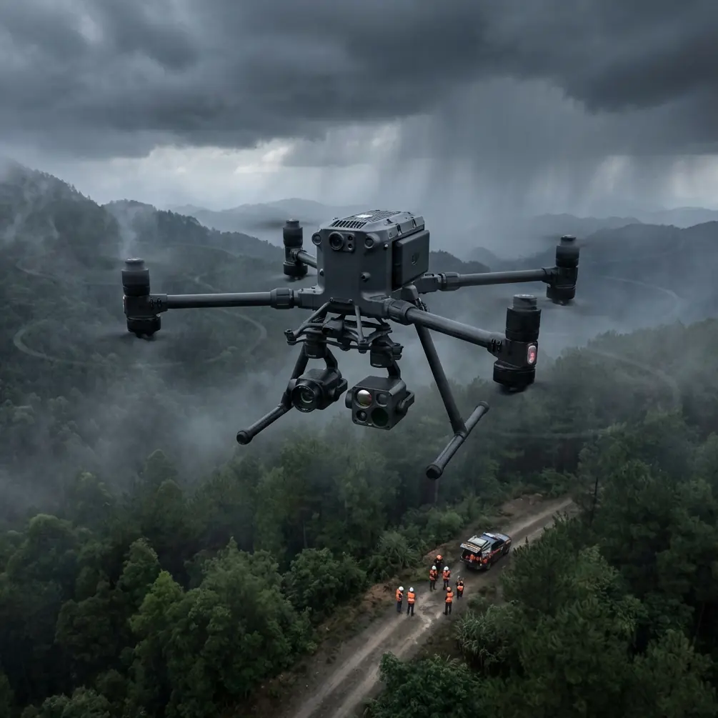
Coastline work looks simple on a map. In practice, it rarely is. Elevation changes fast, wind funnels through cliffs, salt moisture settles where you do not want it, and long linear routes punish any weak point in aircraft setup, payload isolation, or battery planning. That is why the Matrice 400 conversation should not start with headline specs alone. For coastline delivery and inspection missions at altitude, the real story is operational stability.
I approach this as a field specialist, not a brochure writer. The Matrice 400 earns attention when the mission requires repeatability over dramatic terrain: logistics drops to remote coastal infrastructure, thermal signature collection on exposed assets, photogrammetry passes over uneven shorelines, or mixed sensor runs where visual data, thermal data, and georeferenced outputs all need to line up. In these jobs, the aircraft is only one part of the system. The rest is vibration control, transmission integrity, disciplined battery handling, and a workflow that respects how airframes and sensors behave under stress.
A useful way to frame the Matrice 400 for this kind of mission comes from older rotorcraft design literature. One reference section in 飞机设计手册 第19册 直升机设计 focuses specifically on vibration and noise environment issues, including the effect of vibration on the human body, the effect of noise on equipment and people, and a combined vibration-noise environment analysis for equipment and operators. Another section in that same source highlights technical measures used to improve vibration and noise conditions, as well as onboard equipment vibration-environment test standards. Those details matter here because high-altitude coastline operations create exactly the sort of combined environmental stress that can quietly degrade mission quality long before an aircraft triggers an obvious warning.
That may sound abstract, so let me put it in the context of a real mission profile.
The mission profile: high coastline, long route, mixed data needs
Picture a delivery corridor running along a raised coastline with cliffs, service roads, and isolated utility sites. The aircraft launches inland, climbs through shifting air, then transitions to a route where sea-facing gusts push laterally while terrain-reflected turbulence hits from below. If the same airframe is also tasked with capturing thermal signature data or photogrammetry for post-mission modeling, the platform is being asked to do three things at once: stay stable, stay connected, and stay predictable.
This is where Matrice 400 users need to think like systems engineers.
A long coastline route is not merely a distance challenge. It is a vibration exposure problem. Repeated small disturbances can soften image sharpness, bias thermal interpretation, and fatigue operator judgment. The handbook’s discussion of a joint vibration-noise environment is especially relevant. When the aircraft, payload, and crew are all working inside that environment, the effect is cumulative. Equipment reliability and human decision-making both matter. For BVLOS-oriented planning or any extended visual-line mission at altitude, that changes how you build the flight day.
Why vibration matters more than many operators admit
Most drone teams notice vibration only when footage shows rolling artifacts or when a gimbal struggles in stronger wind. That is late-stage evidence. The better approach is to treat vibration as an input variable from mission planning onward.
The rotorcraft design reference explicitly separates several concerns: vibration’s effect on people, noise’s effect on equipment and people, and the combined environment acting on both. For Matrice 400 coastline work, that translates into three practical implications.
First, payload truthfulness. Thermal signature work can be compromised by subtle instability, especially when you are trying to compare assets along a broad route under changing ambient conditions. The issue is not simply whether the image looks usable. The issue is whether the thermal scene is stable enough for consistent interpretation across multiple passes.
Second, mapping accuracy. Photogrammetry over coastlines is unforgiving because texture changes fast—rock, vegetation, surf, man-made surfaces, wet edges. Even when your GCP layout is solid, airframe disturbance can reduce overlap quality or introduce reconstruction inconsistencies in edge zones. This is where transmission confidence and disciplined speed management matter just as much as camera settings.
Third, operator load. The handbook’s inclusion of human impact is not academic filler. Noise and vibration affect fatigue, especially on long shoreline runs where the pilot and sensor operator must maintain continuous attention while dealing with changing topography and moving wind bands. If your mission plan ignores that, performance degrades before batteries do.
The hidden value of engineering math in field drone work
The second source, 飞机设计手册 第1册 常用公式、符号、数表, looks far removed from a drone case study at first glance. It includes sections on matrix transformations, eigenvalues and eigenvectors, probability and statistics, random processes, numerical methods, error theory, regression analysis, curve fitting, smoothing, and filtering. That toolbox is exactly what serious Matrice 400 operations depend on, even if the pilot never says it out loud.
Why does that matter for coastline delivery?
Because real field data is noisy. Signal quality fluctuates. Battery performance drifts with temperature and load. Wind along cliffs behaves like a random process, not a neat average. If you are using the Matrice 400 for route validation, sensor calibration, or repeated corridor mapping, you are already living inside the world of filtering, smoothing, and error analysis.
Take photogrammetry as one example. When teams discuss GCP accuracy, they often focus on placement density and survey quality. Those are essential, but not sufficient. High-altitude coastlines introduce error patterns that are spatially uneven. Regression analysis and smoothing concepts from the engineering reference are directly relevant when you evaluate elevation residuals, shoreline edge reconstruction, or cross-wind distortions between passes. Good operators may not cite chapter numbers, but the thinking is the same: separate random variation from systematic bias.
The same applies to O3 transmission reliability and encrypted data handling. If the mission requires stable command-and-data links with AES-256 protections in a coastal infrastructure setting, you need more than a yes-or-no view of link quality. You need to observe patterns. Where does the link degrade relative to terrain masking? Does altitude improve consistency, or does it expose the aircraft to stronger turbulence that harms image quality? The answer is rarely found in one flight.
A battery management tip that actually saves missions
Here is the field lesson I tell every new Matrice 400 team working along elevated coasts: do not use hot-swap batteries as an excuse to rush turnarounds.
Hot-swap capability is valuable. It reduces downtime and helps keep route schedules intact. But on salt-exposed, high-wind coastline missions, a fast battery exchange can hide two problems. One is thermal imbalance between packs that have just come off a hard leg and packs waiting in a cooler or warmer case. The other is connector complacency—operators move too fast, confirm latch engagement visually, and skip the pause needed to verify the aircraft has fully recognized pack status before re-arming.
My rule is simple. After a hot-swap, take a short diagnostic pause instead of launching immediately. Use that minute to check pack temperature alignment, voltage consistency, cell behavior, payload initialization, and gimbal steadiness at idle. On a long coastal route, losing one leg to a preventable battery anomaly costs far more than losing one minute on the ground.
This habit also helps in high-altitude launches where the first climb segment draws current aggressively. If there is any battery mismatch, you want to see it before the aircraft commits to the ridge line. Too many teams treat battery swaps as a pit-stop contest. They should treat them as a controlled reset.
Why payload isolation should be part of the mission brief
The rotorcraft handbook reference to onboard equipment vibration-environment test standards is one of the most useful clues in the source material. It signals a mindset: payload reliability is not just about whether a sensor functions in ideal conditions. It is about whether the sensor remains truthful in a real vibration environment.
For Matrice 400 users carrying thermal sensors, zoom optics, or mapping payloads, that means payload mounting and post-flight quality assurance deserve a formal place in the checklist. On coastline jobs, I advise teams to brief three questions before takeoff:
- What data product is least tolerant of micro-disturbance?
- At what terrain segment do we expect peak turbulence?
- What mid-mission indicator will tell us the data is drifting before the sortie is over?
If the answer is thermal signature consistency, then use hover checks near representative wind exposure. If it is photogrammetry, monitor overlap confidence and edge sharpness early in the route rather than trusting the whole run. If it is logistics delivery, prioritize route smoothness and landing-zone stability over aggressive schedule compression.
Transmission and data security are not side notes
Coastline infrastructure missions often pass near sensitive civilian assets: communications relays, utilities, harbors, remote service compounds. In that setting, O3 transmission performance and AES-256 protection are not decorative features. They shape whether the operation remains dependable and acceptable to stakeholders.
A stable link matters for obvious reasons, but also for data confidence. If the route is flown for mixed objectives—delivery on the outbound leg, inspection imagery on the return—you need continuity. Intermittent transmission can increase pilot workload and encourage conservative behavior that breaks planned geometry for photogrammetry. Security also matters when captured imagery includes infrastructure layouts or thermal anomalies that should not travel loosely.
When teams ask how to prepare for a coastline route they have never flown, I usually recommend a short planning exchange before the first field day. If you need a practical briefing on route structure, payload matching, or battery workflow, this direct mission planning chat is often the fastest way to sort out the basics without overbuilding the solution.
A better way to think about BVLOS readiness
BVLOS is often discussed as a regulatory threshold. Operationally, it is a discipline threshold. High-altitude coastline missions expose that quickly. You are balancing terrain masking, battery reserves, changing winds, payload stability, and return margins over linear distances where diversion options may be limited.
This is where the engineering reference’s emphasis on probability, statistics, and random processes becomes more than academic. BVLOS readiness is not one perfect route flown once. It is a pattern of repeatable outcomes across variable conditions. You want enough mission history to identify what is random and what is persistent. If one cliff segment regularly causes link attenuation, document it. If one battery set consistently shows higher sag after a long climb, remove it from critical runs. If one payload combination degrades thermal consistency under crosswinds, redesign the sequence.
That is how professional Matrice 400 operations mature: not by assuming stability, but by measuring it.
The real takeaway for coastline operators
The strongest insight from the reference material is not a single formula or isolated design topic. It is the idea that aircraft performance, equipment reliability, and human effectiveness are tied together by the operating environment. The handbook’s sections around page 393 to 398 on vibration, noise, combined effects, mitigation measures, ride-quality standards, and equipment testing all point in that direction. The formulas and statistical tools in the first volume support the same conclusion from another angle: disciplined analysis produces better flying.
For Matrice 400 teams delivering along high coastlines, that translates into a practical operating philosophy.
Treat vibration as a data-quality issue, not just a comfort issue.
Treat noise and fatigue as mission variables, not background conditions.
Treat hot-swap batteries as a managed transition, not a speed trick.
Treat GCP, photogrammetry, thermal signature capture, O3 transmission, and AES-256 security as connected parts of one workflow.
And treat BVLOS readiness as a repeatability problem that has to be earned.
The Matrice 400 is most convincing when it is used that way—inside a disciplined system, on difficult terrain, by operators who understand that reliability is built before launch.
Ready for your own Matrice 400? Contact our team for expert consultation.