Matrice 400 for Mountain Construction Sites: A Field
Matrice 400 for Mountain Construction Sites: A Field-Driven Technical Review
META: Expert review of the Matrice 400 for mountain construction work, covering battery strategy, photogrammetry, thermal signature use, O3 transmission, AES-256 security, and BVLOS-ready operational planning.
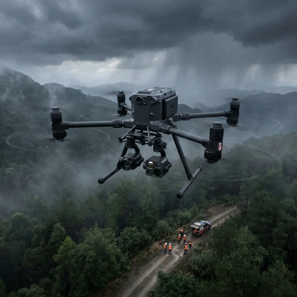
Mountain construction exposes every weak point in an aerial platform. Wind shifts without warning. Ridge lines block signal paths. Temperatures swing hard between sunrise and mid-afternoon. Crews work across broken terrain where a simple walk to confirm progress can eat half an hour. In that setting, the Matrice 400 is not interesting because it is new or large. It matters because it changes how a site can be measured, inspected, and managed when the ground itself slows everything down.
I have spent enough time around steep-access jobs to know that the aircraft is only one part of the equation. The real test is whether the whole system remains useful after the third battery cycle of the day, when dust is in the connectors, the light is flattening, and your pilot is trying to capture both photogrammetry data and thermal observations before weather closes the window. That is where the Matrice 400 becomes worth discussing seriously.
This is not a generic overview. If your job involves delivering oversight on mountain construction sites, the Matrice 400 deserves attention for a few practical reasons: stable data collection for terrain-heavy mapping, transmission resilience across obstructed geography, stronger security posture for sensitive project files, and battery handling that supports sustained site coverage without turning each sortie into a reset.
The first operational advantage is payload flexibility tied to terrain reality. On a mountain build, you rarely fly one clean mission type. Morning might require high-overlap photogrammetry of a cut slope and access road. By midday, the superintendent wants a thermal look at a recently installed electrical run, a retaining structure with suspected moisture intrusion, or a piece of equipment running hotter than expected. A platform that can support different sensing tasks without becoming awkward in the field immediately saves time. That is especially valuable when staging areas are small and launch points are constrained by elevation, traffic, and slope.
Photogrammetry in mountain construction is not simply “fly a grid and process a model.” Relief displacement becomes more punishing as terrain varies sharply. Tall stockpiles, stepped excavation faces, and narrow haul roads introduce reconstruction errors if the mission geometry is lazy. The Matrice 400 makes the most sense when paired with disciplined capture planning: tighter sidelap than you would use on flatter jobs, deliberate oblique passes on vertical features, and GCP placement that respects line-of-sight and elevation spread. Too many teams place ground control where it is convenient rather than where the terrain demands it. On mountain sites, that shortcut shows up later as warped edges, poor tie point consistency, and disappointing volume calculations.
That is one reason I like using the Matrice 400 as part of a repeatable surveying workflow rather than treating it as a one-off flying camera. If your construction team needs progress models that can stand up to engineering scrutiny, consistency matters more than headline specs. Fly from the same launch zone when possible. Keep your GCP network distributed across lower and upper benches. Avoid collecting the entire site in one giant, high-altitude compromise mission if the topography is complex enough to justify segmented captures. The aircraft can cover a lot, but the smartest operators still break the site into logical blocks.
Then there is thermal work, which is often misunderstood on mountain projects. Thermal imagery is not just for finding hot electrical components. Used correctly, it can help identify drainage problems, insulation irregularities in temporary structures, heat stress in machinery, and anomalies in recently placed material. The phrase “thermal signature” gets tossed around loosely, but on a mountain job the useful question is more specific: what thermal contrast is operationally meaningful at this hour, in this wind, on this surface?
The Matrice 400 becomes more valuable when pilots and site managers stop asking for “a thermal scan” and start asking targeted questions. Is runoff cooling one section of a retaining wall differently from the rest? Is a generator enclosure trending hotter than yesterday under similar load? Is a newly installed roof membrane showing inconsistent temperature distribution that might justify closer inspection? These are the kinds of jobs where aerial thermal data saves human effort and narrows the inspection area before anyone hikes the slope.
Transmission reliability is another major reason the platform suits mountain construction. O3 transmission is not just a brochure term in this environment. In steep terrain, signal quality suffers for very physical reasons: rock faces shadow the aircraft, mobile equipment creates moving interference sources, and the pilot often cannot choose an ideal operating position because the only safe launch point is beside an active work zone. A stronger transmission system improves more than pilot confidence. It improves decision quality. When the live feed remains dependable, the team can verify overlap, inspect edge conditions, and adjust flight paths before a bad mission has to be repeated.
That matters financially, but the bigger issue is operational tempo. On a mountain project, a repeated mission is not a small inconvenience. It may mean losing the weather window, extending crew exposure near unstable ground, or delaying a concrete pour because the latest progress verification did not come back cleanly. O3 transmission, in practical terms, helps reduce those cascading setbacks by preserving situational awareness in places where line-of-sight is never as simple as it looks on a map.
Security also deserves more attention than it usually gets in drone discussions. Construction data is now deeply tied to claims management, schedule verification, and infrastructure documentation. High-resolution site models, thermal inspection files, and annotated progress imagery are not casual media assets. They are project records. AES-256 support is therefore not an abstract checkbox. It has operational significance because it aligns drone-collected information with the broader security expectations already present in serious construction and engineering environments.
If a mountain site is tied to transport, energy, telecom, or public infrastructure, there is a good chance multiple stakeholders need controlled access to imagery and derived models. Encryption helps protect that chain. It also makes it easier for risk-conscious project managers and IT teams to accept UAV workflows without treating the flight unit as an unmanaged exception. The Matrice 400’s security posture is one of those features that rarely gets praise from field crews but often determines whether a drone program scales beyond a few enthusiastic pilots.
Battery management, though, is where field discipline separates efficient teams from frustrated ones. Hot-swap batteries sound like a convenience feature until you are operating in thin mountain air with long transit legs to the area of interest. Then they become central to mission continuity.
Here is the tip I give teams after watching avoidable battery problems on elevated construction sites: do not judge swap timing by percentage alone. Judge it by battery temperature trend, outbound distance, and the energy cost of climbing back through wind. Pilots who wait too long because the displayed percentage still looks healthy often forget that the return leg is not symmetrical. A mission that started with a calm descent into a protected area may end with an uphill climb into gusts after the sun has shifted the local airflow. The battery does not care that your plan looked fine on the tablet.
My preferred habit is simple. After each flight, log not just remaining charge but how the pack behaved under the site’s current wind and elevation conditions. By the second or third sortie, you can spot whether the aircraft is consuming more reserve during climbs or while holding position over exposed ridges. Once that pattern appears, shorten the next mission before the battery forces the decision for you. On paper, that sounds conservative. In practice, it produces more usable flights across a workday because you avoid stress returns, overheated packs, and ragged data collection at the edge of endurance.
Hot-swap capability helps here because it compresses downtime between missions, but it should not encourage sloppy planning. The best crews use it to maintain momentum, not to excuse poor battery discipline. On mountain construction jobs, I would rather see a shorter, cleaner mission with an orderly swap than one ambitious route that returns with uneven overlap, weak thermal data, and a pilot already thinking about the warning thresholds.
There is also a growing conversation around BVLOS potential for large, distributed projects in difficult terrain. Mountain construction sites often stretch across access roads, spoil areas, staging compounds, utility corridors, and upper-slope work fronts. Keeping all of that in visual range can be unrealistic, particularly when the geography itself blocks observation. The Matrice 400 fits naturally into this discussion because the platform characteristics point toward more advanced operational use cases, including structured BVLOS programs where regulations, waivers, and risk controls allow it.
That does not mean teams should treat BVLOS as a shortcut. It means the aircraft can be part of a maturing operational model. If your site eventually needs corridor inspections between work zones or repeated logistics oversight across separated areas, choosing a platform with credible transmission, security, and endurance workflow advantages early on can save painful fleet transitions later. Even when flying strictly within visual line of sight today, many construction managers are already making procurement decisions with tomorrow’s operating approvals in mind.
What I appreciate most about the Matrice 400 in this context is that it supports serious work without demanding a fantasy jobsite. Real mountain construction is messy. Vehicles move unexpectedly. Dust contaminates setups. Survey markers get disturbed. Supervisors ask for one extra look at the far berm when the aircraft should already be coming home. A useful platform is one that absorbs some of that disorder while still delivering reliable outputs.
If I were setting up a mountain construction workflow around the Matrice 400, I would build it around three repeatable mission types. First, a scheduled photogrammetry block for progress and volumetrics, anchored by well-maintained GCPs distributed across elevation bands. Second, a targeted thermal inspection flight timed for the specific contrast needed, not squeezed randomly between other tasks. Third, a short-response visual verification mission for ad hoc site questions that emerge during the shift. This structure sounds basic, but it keeps the aircraft from becoming a general-purpose gadget and turns it into a dependable site instrument.
The operational edge comes from the details: using O3 transmission to maintain clean oversight in obstructed terrain, protecting deliverables through AES-256-aligned security practices, treating hot-swap batteries as part of a disciplined energy strategy, and capturing thermal signature data with a purpose rather than curiosity. Those are not glamorous decisions. They are the ones that keep a drone program credible after the novelty wears off.
For teams trying to refine that workflow on an active project, I usually recommend mapping the site’s worst signal shadows and worst battery-demand segments during the first week of operations. That small investment pays back quickly. It tells you where to relocate the pilot station, where to avoid long hovers, and where to split a single mission into two safer flights. If you want to compare notes on setting up that kind of mountain-site flight plan, you can reach me through this field coordination channel.
The Matrice 400 is not valuable because it promises everything. It is valuable because on hard terrain it addresses the parts of UAV work that tend to break first: continuity, signal confidence, data security, and repeatable capture quality. For mountain construction sites, that makes it less of a showpiece and more of a working aircraft.
Ready for your own Matrice 400? Contact our team for expert consultation.