Matrice 400 in Dusty Agricultural Deliveries
Matrice 400 in Dusty Agricultural Deliveries: A Case Study in Flight Planning, Data Discipline, and Why Altitude Matters
META: Expert case study on using Matrice 400 for dusty field delivery missions, with practical altitude insight, GIS workflow context, and operational lessons for safe, efficient civilian UAV deployment.
Dust changes everything.
On paper, a field delivery mission looks simple: launch, cross a few parcels, drop or hand off payload, return. In reality, agricultural environments are rough on aircraft systems, hard on visibility, and unforgiving when workflows are loose. If you are evaluating the Matrice 400 for deliveries across dusty farmland, the real question is not whether the platform can fly the route. The question is whether your operation can stay consistent when fine particulates, patchy terrain data, and repeated sorties start stacking up.
That is where the Matrice 400 conversation gets interesting.
This article is built around a specific operating scenario: delivering across dusty fields, where route reliability, data handling, and mission repeatability matter as much as raw flight capability. The overlooked variable here is flight altitude. Not maximum altitude. Optimal altitude. Fly too low and rotor wash kicks up dust, compromises visual awareness, and increases contamination around landing or handoff zones. Fly too high and you trade away delivery precision, visual confirmation, and sometimes transmission margin at the field edge. For this type of work, altitude is not just a safety setting. It is a business variable.
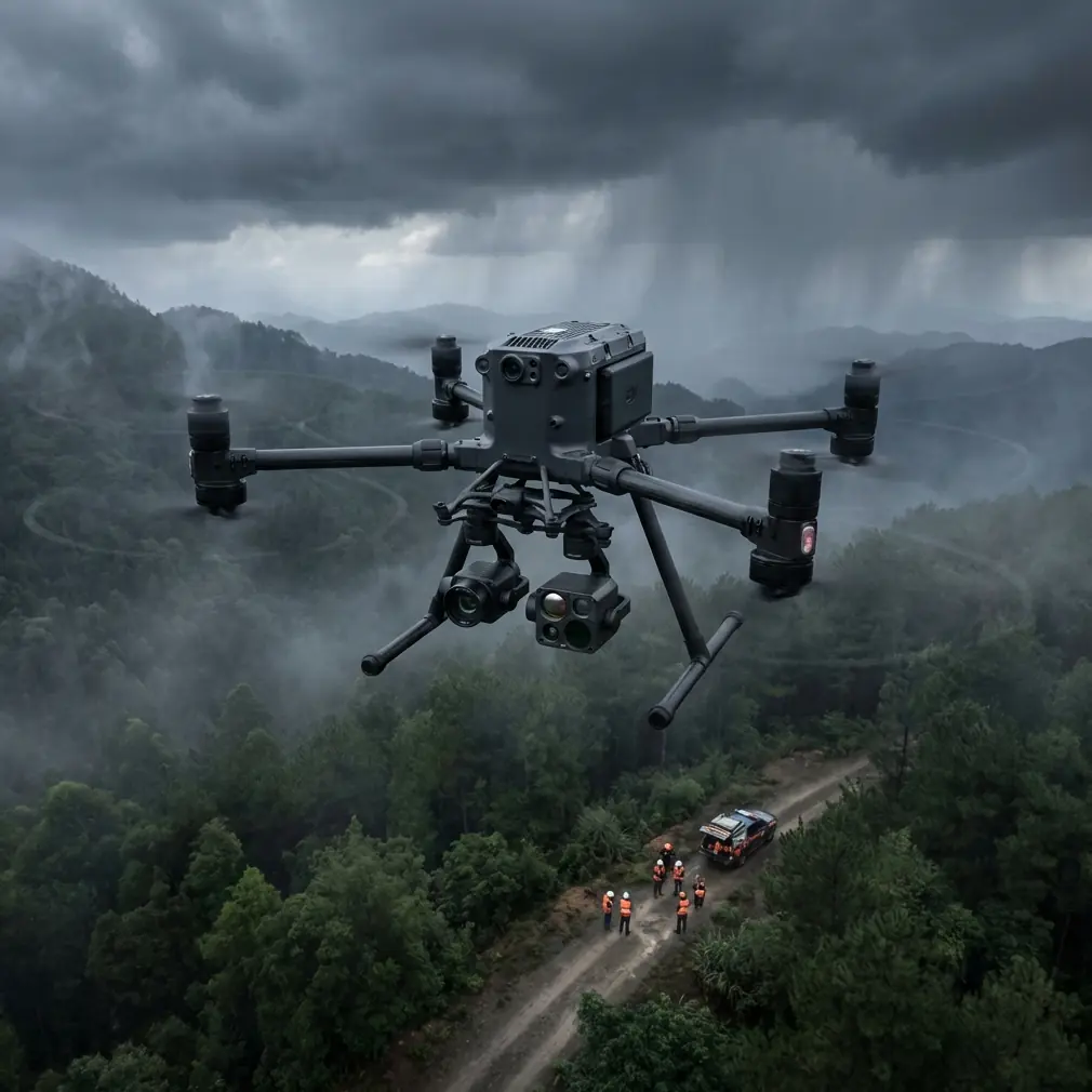
The first operational decision: stay above your own dust
For dusty agricultural delivery work, the best starting point is usually not the lowest legal or convenient height. It is the lowest altitude that avoids creating your own visibility problem.
In practical field operations, that often means cruising high enough above uneven crops, access roads, and dry soil to keep rotor wash from disturbing loose dust except during the final delivery phase. For many missions, that sweet spot will be above the height a pilot might instinctively choose when trying to “hug the route” for visual comfort. The instinct is understandable. The result often is not.
A Matrice 400 deployed in farm environments should be planned around three altitude bands:
- Transit altitude high enough to stay clear of crop variation, irrigation structures, and dust plumes from nearby vehicles.
- Approach altitude where the aircraft slows and begins refining its position over the drop or transfer point.
- Delivery altitude kept as short in duration as possible, because this is where dust contamination risk rises sharply.
That simple segmentation matters. It cuts the time spent in the dirtiest air and preserves cleaner sensor views for the parts of the mission where confirmation is most important.
If you are designing standard operating procedures for this kind of deployment, make altitude a mapped mission parameter, not an improvised pilot choice.
Why dusty-field delivery is really a data problem
Most teams approach delivery operations as an aircraft problem first and a logistics problem second. In agriculture, I would reverse that. Dusty-field missions become manageable when your spatial data is organized well enough that crews are not reinventing routes, boundaries, and destination points every week.
This is where the GIS reference material becomes more relevant than it may appear at first glance. One source describes geodatabase design as an open storage model that is not locked to a single database vendor and can work across DBMS, file-based storage, or XML-based methods. That sounds abstract until you apply it to UAV operations.
For a Matrice 400 delivery program, that openness has direct operational value. A field logistics team may be working with parcel boundaries, farm roads, temporary drop zones, utility easements, CAD-derived site sketches, imagery, and text-based delivery notes. According to the ArcGIS reference, metadata can be created and managed for many formats, including ESRI Shapefile, CAD drawings, imagery, GRID, TIN, tables, maps, layers, and text. That breadth matters because farm delivery routes rarely begin life in one clean system.
One manager may mark a landing buffer in CAD. A surveyor may export terrain as TIN. An agronomy team may work off raster imagery. A contractor may send coordinates in a spreadsheet. If your Matrice 400 deployment is expected to run repeat missions efficiently, you need a data environment that absorbs all of that without creating route ambiguity.
In other words, the aircraft is only as repeatable as the map behind it.
The hidden value of metadata in UAV delivery work
Dusty agricultural deliveries often happen on land that changes by the season. Trackable metadata is what keeps a route current instead of merely familiar.
The ArcCatalog reference is useful here because it highlights a module designed to organize and manage maps, datasets, models, metadata, and services, while using XML as a metadata standard and supporting routine management actions like copy, delete, and rename. That is not a software trivia point. It is an operational control point.
Let’s say your Matrice 400 team maintains 40 recurring delivery points across multiple fields. Some are safe year-round. Some become unsuitable after irrigation layout changes. Some need adjusted approach corridors during harvest traffic. If these changes live only in pilot memory or in informal notes, the mission risk rises every month.
With disciplined metadata, each delivery point can carry operational context:
- preferred approach direction in dusty wind conditions
- whether a landing or low-hover handoff is appropriate
- seasonal obstacles
- nearby power infrastructure
- photogrammetry update date
- whether GCP-backed survey confidence exists for the current terrain model
That is how you turn a capable aircraft into a dependable operation.
Altitude insight: use terrain confidence, not habit
Here is the altitude lesson I would emphasize for dusty field delivery missions with Matrice 400: pick your cruise altitude based on terrain confidence and dust behavior, not pilot comfort alone.
If your route runs over fields that have been recently mapped using photogrammetry and verified with GCP-backed control, you can justify tighter altitude planning because you trust the shape of the ground and the position of features. If the route is based on stale imagery or loosely described field edges, add vertical margin.
That is why photogrammetry belongs in the delivery discussion even when the mission itself is not a mapping flight. Good mapping reduces delivery uncertainty.
Thermal signature analysis can also play a supporting role. Not because you are trying to “see through dust” in some magical sense, but because thermal patterns can help identify active machinery, recently used access tracks, livestock concentrations, or heat-retaining obstacles during certain operating windows. In a civilian farm workflow, that can improve approach planning and keep delivery endpoints better separated from active ground operations.
Transmission integrity matters more at the field edge
The farther a delivery route pushes from a farmhouse, field office, or support vehicle, the more link stability starts to shape procedure. That is where O3 transmission becomes part of the altitude conversation. In broad agricultural landscapes, a moderate increase in cruise altitude can improve line-of-sight conditions and reduce interruptions caused by terrain undulation, tree belts, storage sheds, or scattered infrastructure.
This does not mean “higher is always better.” It means altitude can be used as a transmission tool. On long field-edge routes, the correct altitude often gives you better command continuity and cleaner video verification before you ever descend into the dustier delivery segment.
Security also deserves a brief mention. If your delivery operation handles route libraries, farm infrastructure imagery, or sensitive crop-service logistics, AES-256-level transmission security is not just a spec-sheet talking point. It supports client trust and internal governance. Agricultural operations increasingly treat field data as proprietary. Your drone workflow should reflect that.
Why environmental durability standards should influence UAV thinking
One of the supplied technical references comes from aircraft fuel tank installation testing, not drones. At first glance it seems unrelated. It is not.
That document describes acceptance standards under vibration, shaking, pressure, and temperature stress. It includes concrete test details: vibration frequency at 33.3 Hz, measurement of vibration displacement using electronic instruments with average peak values recorded over 30-second intervals, shaking tests of 25 hours, and in one method an added 15 hours of pure motion at 10 to 15 cycles per minute. It also describes a low-temperature sequence reaching -55°C for at least 3 days after staged conditioning.
No, that does not mean you should apply aircraft fuel tank procedures to a Matrice 400. The significance is broader. Reliable aerial systems are validated against sustained environmental stress, not just brief functional checks. For dusty agricultural delivery programs, operators should borrow that mindset.
What does that look like in practice?
- Repeat sortie testing in dusty conditions, not just a single demo flight
- Inspection routines after vibration-heavy transport on farm tracks
- Structured review of payload mounts and connectors after repeated field landings
- Verification that electrical behavior remains stable after dust exposure and thermal swings
The aircraft manual will provide official maintenance guidance. Your job as an operator is to build a field reality around it. The reference’s rejection criteria for leakage, structural damage, or electrical malfunction after stress testing underline a principle every commercial UAV team should understand: hidden degradation is still degradation.
If a Matrice 400 program is meant to support recurring delivery across rough, dry terrain, resilience should be measured over dozens of cycles, not assumed after day one.
A realistic case workflow for Matrice 400 in dusty fields
Here is the kind of workflow I recommend for teams building a delivery program around this scenario.
1. Build a route library, not one-off flights
Use a geodatabase-backed structure to store:
- field boundaries
- approved departure points
- delivery coordinates
- restricted approach corridors
- terrain notes
- seasonal hazards
Because the GIS reference highlights support for multiple data types and metadata management, this approach scales better than ad hoc mission files scattered across laptops.
2. Survey first if terrain confidence is weak
Run a photogrammetry mission before routine deliveries begin. Use GCPs where positional confidence matters near irrigation structures, berms, or narrow approach corridors. The point is not perfection. The point is reducing unknowns.
3. Define altitude by segment
Set a conservative cruise band for the dusty field environment, then script or brief lower approach and delivery altitudes only where needed. This reduces dust disturbance and improves repeatability.
4. Use low-hover transfers where ground conditions are poor
If the destination zone is powder-dry or visibility is easily degraded, minimizing the time spent in the rotor-wash-intensive zone can keep the mission cleaner and safer.
5. Monitor system condition after repeated cycles
Dust is cumulative. Vibration from transport is cumulative. Heat is cumulative. Borrow the discipline implied by the aviation stress-testing reference even though your platform is different.
6. Keep field communications simple
If crews need route setup advice or a quick second opinion on mission structure, a direct operations channel often solves problems faster than email chains. A field team can message an integration specialist here when route planning or payload workflow questions need immediate clarification.
Hot-swap batteries and mission continuity
For recurring field deliveries, hot-swap batteries can be more valuable operationally than many teams expect. In dusty agriculture, faster turnarounds are not only about productivity. They reduce the temptation to leave the aircraft exposed on the ground while crews reorganize. Less idle time on dirty surfaces generally means better discipline and fewer contamination opportunities.
This becomes especially useful when missions are bundled: deliver to one plot, return, swap, redeploy, and maintain route timing while weather and field activity remain predictable.
It also supports BVLOS-oriented workflow planning where permitted and properly authorized. The operational payoff is not simply longer reach. It is steadier tempo. Predictable tempo reduces mistakes.
The bigger takeaway
The Matrice 400 is most compelling in dusty agricultural delivery work when treated as one component of a controlled spatial operation. The flashy parts of drone discussions tend to be airframe capability, payload options, or range claims. In real field use, the winning combination is less glamorous: reliable route data, disciplined metadata, smart altitude selection, secure transmission, and maintenance thinking shaped by actual environmental stress.
Two reference details stand out for a reason.
First, the GIS material’s emphasis on an open geodatabase model and broad metadata support is operationally significant because farm delivery networks depend on mixed data sources and constant updates. Without that flexibility, route reliability erodes fast.
Second, the aircraft testing document’s hard numbers, such as 33.3 Hz vibration testing and 25-hour shake durations, matter because they remind serious operators that endurance is proven through structured stress, not assumed from initial performance. That mindset fits dusty UAV deployment perfectly.
If you are planning Matrice 400 field deliveries, start with altitude discipline. Then build the data architecture and maintenance culture to support it. Dust punishes shortcuts. Good systems do not.
Ready for your own Matrice 400? Contact our team for expert consultation.