Matrice 400 in a Windy Forest Delivery Mission
Matrice 400 in a Windy Forest Delivery Mission: A Field Report from the Edge of Stability
META: Expert field report on using the Matrice 400 for windy forest delivery, with insights on mid-flight weather shifts, data integrity, transmission security, thermal signature awareness, BVLOS planning, and why disciplined system validation matters.
I’ve spent enough time around aircraft and industrial drones to know that “windy forest delivery” sounds simple only to people who have never tried it.
On paper, the route is manageable: lift from a cleared staging area, climb above the tree line, push across uneven terrain, descend into a tight reception zone, and deliver without stirring up branches, dust, or confusion on the ground. In practice, a forest route is a shifting corridor. Wind curls over ridges, spills into canopy gaps, and changes character every few hundred meters. GPS quality can fluctuate. Visual references flatten. Radio paths that looked clean during planning can become inconsistent once the aircraft drops near tall timber.
That is exactly where the Matrice 400 starts to matter—not as a spec-sheet object, but as a working aircraft system.
This field report is built around one central question: what does a serious delivery platform need to prove when the mission is real, the weather changes mid-flight, and the route runs through forest in unstable wind?
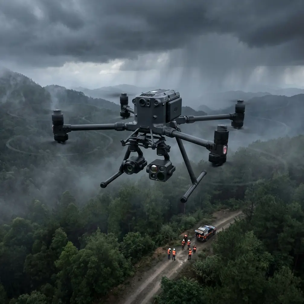
The mission profile that exposes weak aircraft
The job was straightforward in purpose: deliver essential payload to a forestry team operating beyond easy road access. No dramatic marketing scenario. Just the sort of task that reveals whether a platform is genuinely operational or merely promising.
Forests create two kinds of aerodynamic trouble. The first is broad-area wind, the kind you can model from forecasts and topography. The second is local turbulence generated by the landscape itself—tree crowns, ravines, clearings, and thermal gradients. A drone can look stable over an open launch site and become noticeably busier on the controls once it crosses a ridge and enters broken airflow.
With the Matrice 400, the real test wasn’t simply whether it could fly the route. It was whether it could keep the mission organized as conditions changed: aircraft behavior, pilot workload, data logging, transmission confidence, and the discipline to continue or abort based on evidence rather than optimism.
That distinction matters.
Mid-flight, the weather turned
About a third of the way into the route, the wind picked up and rotated. It wasn’t a dramatic storm front; those are easy to spot and easy to avoid. This was the more operationally annoying version: a moderate shift in direction, stronger gusts at canopy height, and a subtle drop in visual clarity as moisture moved through the valley.
The Matrice 400 handled the transition the way a professional delivery drone should—by staying predictable.
Predictability is underrated. People often talk about power, endurance, or payload, but for forest logistics, the ability to maintain a steady, interpretable flight profile is what protects the mission. When wind changes mid-flight, an aircraft that remains legible to the crew gives you options. You can adjust route geometry, revise the descent corridor, or alter the drop timing without compounding risk.
This is where O3 transmission architecture becomes operationally meaningful rather than just impressive jargon. In wooded terrain, the command-and-video link is part of the safety envelope. A robust transmission path helps the crew make clean decisions when the aircraft is entering an area where wind and terrain are already increasing workload. The value is not that the link exists; it’s that it remains usable when you most need situational clarity.
And because delivery missions often involve route data, operational locations, and customer-sensitive logistics, secure transmission matters too. AES-256 isn’t just a box to tick for enterprise procurement. In real operations, especially BVLOS-oriented workflows, it supports the basic expectation that telemetry, video, and mission-relevant traffic aren’t being treated casually.
Why serious drone operations borrow lessons from crewed aircraft
One of the most useful habits in professional UAV work is studying what mature aviation systems already solved.
The reference material behind this piece includes a technical section on flight data recording systems. One detail stands out: a validated recording system must confirm its intended function and preserve accuracy across all normal flight phases—taxi-equivalent movement, takeoff, climb, cruise, descent, approach, and landing—and account for 17 required parameters in the FAA framework cited in the source material.
That number matters because it reflects a mindset, not just a regulation.
For a Matrice 400 forest delivery mission, the equivalent lesson is simple: if you can’t trust your aircraft data before, during, and after each segment of the route, you are managing the mission on intuition. And intuition degrades fast when wind changes, terrain complicates link quality, and a delivery descent must be placed precisely inside a constrained landing or drop zone.
I’m not suggesting the Matrice 400 is governed by the same framework as a crewed transport aircraft. It isn’t. But the operational principle transfers perfectly. Data logging should not be treated as passive background activity. It is what lets teams reconstruct battery behavior, route efficiency, altitude discipline, wind effect, and control stability after the mission. That is how good operators refine future BVLOS planning and develop safer standard operating procedures.
If a crew says, “the aircraft felt fine,” that is anecdote. If the flight record shows where power demand increased, where the groundspeed changed against wind, and where the aircraft spent extra energy stabilizing during descent, that is operational knowledge.
Wind in the forest is not only a flight problem
Delivery teams tend to think first about whether the aircraft can hold position. Fair enough. But in forest operations, the harder question is whether the full mission system remains coherent under stress.
The same reference set includes another technical discussion—this time from aircraft fueling system design. At first glance, it seems unrelated to drones. Look closer and it becomes surprisingly relevant. The source describes a preselection logic with a two-digit display, quantity management steps, and a built-in invalid-state warning if the operator enters values in the wrong sequence. It also describes a stop signal when the target quantity reaches “00”.
Why does that matter to a Matrice 400 mission?
Because it captures the value of disciplined human-machine interface design. In delivery operations, especially when crews are under time pressure, the system must make correct action easier than incorrect action. Payload confirmation, route selection, battery sequencing, RTH behavior, and handoff timing should all be unmistakable. Forest missions in changing weather are not the place for ambiguous panel logic, vague status states, or workflows that depend on memory alone.
The best drone operations borrow from this aviation principle: operational tasks should be designed so that invalid inputs reveal themselves early, not after the aircraft is committed to the route.
That’s one reason hot-swap batteries matter beyond convenience. Their value is not merely faster turnaround. Their value is procedural continuity. In a field environment where weather windows can open and close quickly, hot-swap support allows crews to maintain rhythm while preserving aircraft readiness and minimizing unnecessary reboot-and-reconfigure cycles between sorties. Done properly, it reduces friction exactly where field teams usually bleed time.
Descent planning under canopy-edge turbulence
The outbound leg in our scenario was manageable. The inbound descent to the forest team was harder.
Canopy-edge turbulence is one of those effects people underestimate until they see it firsthand. As the Matrice 400 approached the reception zone, the air got rougher below the treetops and strangely inconsistent near an adjacent clearing. This is where a stable aircraft and a disciplined pilot complement each other.
I prefer to think of the final approach in three layers:
- Macro positioning above the trees
- Transition management down into disturbed air
- Delivery execution with minimal hover indecision
The Matrice 400’s usefulness here comes from staying composed enough that the operator can keep working the plan rather than improvising every second. That is the difference between a platform suited for logistics and one that is merely capable of lifting a payload.
Thermal signature also plays a role in this environment, though not in the sensationalized way it is often discussed. In civilian forest operations, thermal data can help teams maintain awareness of people, equipment, or recently active machinery near the delivery point, particularly when visibility is cluttered by vegetation or changing light. It’s a practical layer of scene interpretation. Not magic. Not a substitute for visual procedures. Just another input that reduces guesswork.
Mapping logic improves delivery reliability
A lot of teams separate mapping from logistics. In forest operations, that’s a mistake.
Photogrammetry and properly placed GCPs can materially improve delivery planning before the first live mission ever launches. When you build a reliable terrain model of the corridor, you gain more than pretty maps. You gain better understanding of climb gradients, likely wind-exposure zones, emergency divert areas, and more precise approach geometry into constrained forest clearings.
For Matrice 400 operators, this means a delivery workflow can be built on site truth instead of screen assumptions. In wooded terrain, small vertical and horizontal inaccuracies have outsized consequences. A route that looks acceptable in a coarse map can become awkward once you account for tree height variation, slope, and the actual shape of the available touchdown or drop area.
This is why the best delivery programs are often data programs first.
A drone film festival teaches an unexpected lesson
One of the reference items for this article seems unrelated at first: a nominee at the New York City Drone Film Festival, created by Giles Campbell Longley and Kie Willis, featuring footage of extreme athletic activity.
That might sound far from a Matrice 400 forest delivery mission, but it carries a useful reminder. High-motion aerial work exposes whether an aircraft can keep a coherent image when subjects, angles, and environmental forces are all changing rapidly. In commercial drone operations, that same truth applies to logistics. Dynamic scenes reveal stability, and stability reveals platform maturity.
The point is not to compare a forest delivery to filming athletes. The point is that demanding aerial environments strip away marketing language quickly. Whether the aircraft is tracking motion for cinema or negotiating shifting wind over trees for a delivery route, the same operational question appears: can the platform stay controlled, intelligible, and trustworthy when the environment stops cooperating?
That’s the standard serious operators should care about.
What I would tell a team deploying the Matrice 400 for this work
If your delivery routes run through forest and your weather is never as stable as the forecast claims, the Matrice 400 should be evaluated as a system, not a flying box.
Look at five things.
First, transmission resilience. O3-class link performance matters because command clarity and video confidence directly influence go/no-go and descent decisions.
Second, data discipline. Take the lesson from flight data recording practice seriously. Logging isn’t administrative overhead. It is the foundation for route improvement and incident prevention.
Third, security posture. AES-256 is relevant because industrial drone operations increasingly move sensitive route, site, and operational information.
Fourth, energy workflow. Hot-swap batteries help preserve sortie tempo when the weather gives you only narrow windows to move.
Fifth, terrain intelligence. Photogrammetry and GCP-supported modeling reduce surprises before the aircraft ever enters the valley.
If you’re actively planning routes like this and want to compare mission setups, emergency procedures, or payload workflow, you can message our field team here.
The deeper takeaway from the flight
The most revealing moment in this mission was not takeoff, cruise, or delivery. It was the weather shift in the middle, when the original plan became less elegant and the aircraft still remained manageable.
That is when you find out what kind of tool you are actually flying.
A forest delivery drone does not earn trust because it looks industrial or carries a known badge. It earns trust when wind rotates, moisture creeps in, the descent gets ugly, and the crew still has enough clarity to make measured decisions. The Matrice 400, in this kind of profile, is best understood as an aircraft for professionals who care about system integrity: stable flight behavior, clean transmission, usable data, secure operations, and repeatable field workflow.
That combination is what turns a hard route into a routine one.
And in commercial drone delivery, routine is the real benchmark.
Ready for your own Matrice 400? Contact our team for expert consultation.