Matrice 400 Highway Delivery: High Altitude Guide
Matrice 400 Highway Delivery: High Altitude Guide
META: Master high-altitude highway deliveries with the Matrice 400. Expert guide covers antenna positioning, thermal monitoring, and BVLOS operations for peak performance.
TL;DR
- Antenna positioning at 45-degree angles maximizes O3 transmission range in mountainous highway corridors
- High-altitude operations above 4,500 meters require specific battery management and thermal signature monitoring
- Hot-swap batteries enable continuous delivery runs across extended highway stretches
- Proper GCP placement along delivery routes ensures sub-centimeter photogrammetry accuracy for landing zones
Why High-Altitude Highway Delivery Demands Specialized Drone Operations
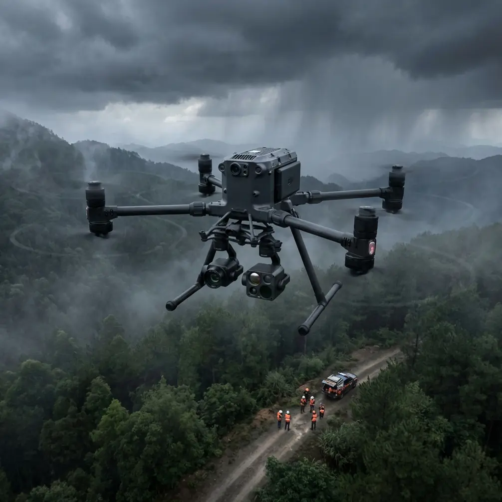
Highway infrastructure at elevation presents unique challenges that ground-based delivery simply cannot solve. Mountain passes, remote construction zones, and isolated maintenance stations often sit hours from distribution centers.
The Matrice 400 transforms these logistical nightmares into streamlined operations. Its robust airframe handles thin air, unpredictable thermals, and the extended distances that define high-altitude highway corridors.
This guide breaks down exactly how to configure, deploy, and optimize your Matrice 400 for reliable highway deliveries when elevation works against you.
Understanding High-Altitude Operational Parameters
Thin air changes everything about drone flight. At 4,000+ meters, air density drops by approximately 40% compared to sea level. This directly impacts lift, battery performance, and cooling efficiency.
The Matrice 400 compensates through its intelligent flight controller, which automatically adjusts motor output and prop pitch. However, operators must understand these limitations to plan effective delivery routes.
Critical Altitude Thresholds
| Altitude Range | Air Density Loss | Battery Impact | Recommended Payload |
|---|---|---|---|
| Sea Level - 1,500m | 0-15% | Minimal | Full capacity |
| 1,500m - 3,000m | 15-30% | 8-12% reduction | 90% capacity |
| 3,000m - 4,500m | 30-42% | 15-22% reduction | 75% capacity |
| 4,500m - 6,000m | 42-52% | 25-35% reduction | 60% capacity |
Planning delivery payloads without accounting for altitude guarantees failed missions. The Matrice 400's flight planning software includes altitude compensation, but manual verification remains essential for critical deliveries.
Antenna Positioning for Maximum Highway Range
Here's what separates successful high-altitude operations from frustrating signal dropouts: antenna geometry matters more than raw transmission power.
The Matrice 400's O3 transmission system delivers exceptional range under ideal conditions. Highway corridors, however, rarely offer ideal conditions. Mountain walls create multipath interference. Metal guardrails reflect signals unpredictably. Tunnel entrances create instant blackout zones.
Optimal Antenna Configuration
Position your ground station antennas at 45-degree angles relative to the primary flight path. This orientation captures both direct line-of-sight signals and beneficial reflections from terrain features.
For highway operations specifically:
- Mount antennas 3-5 meters above road surface level
- Angle primary antenna toward the most distant delivery point
- Position secondary antenna perpendicular to highway direction
- Use directional antenna boosters for corridors exceeding 8 kilometers
Expert Insight: When operating in valleys between mountain ridges, I position my ground station on elevated pullouts rather than valley floors. The extra 50-100 meters of elevation often doubles effective transmission range by clearing the Fresnel zone obstruction that valley floors create.
Signal Management Through Terrain
Highway routes rarely follow straight lines at altitude. Switchbacks, tunnels, and ridge crossings demand proactive signal management.
The Matrice 400's AES-256 encrypted link maintains security even when signal strength fluctuates. However, encryption overhead means you need stronger base signals than unencrypted systems.
Pre-map your route for signal shadow zones. The Matrice 400's autonomous waypoint system handles brief signal interruptions gracefully, but extended blackouts trigger return-to-home protocols that abort deliveries.
Thermal Management in Extreme Conditions
High-altitude highways experience temperature swings that stress drone systems. Morning deliveries might launch at -15°C, while afternoon returns face +25°C on sun-baked asphalt.
The Matrice 400's thermal signature monitoring provides real-time component temperature data. Use this information actively, not just as a warning system.
Pre-Flight Thermal Protocol
Cold batteries deliver reduced capacity and voltage sag under load. The Matrice 400's intelligent batteries include heating elements, but proper pre-conditioning accelerates readiness:
- Store batteries at 20-25°C before deployment
- Run heating cycle for minimum 8 minutes below 10°C ambient
- Verify cell voltage balance before each flight
- Monitor internal resistance readings for degradation
In-Flight Thermal Monitoring
Watch motor temperatures during climb phases. Thin air reduces cooling efficiency precisely when motors work hardest. The Matrice 400 throttles performance automatically at critical thresholds, but this impacts delivery timing.
Pro Tip: Schedule demanding climbs during cooler morning hours. A 10°C reduction in ambient temperature can extend motor thermal headroom by 15-20%, allowing faster ascent rates and shorter delivery windows.
Hot-Swap Battery Operations for Extended Routes
Highway delivery routes often exceed single-battery range. The Matrice 400's hot-swap battery system enables continuous operations without full shutdowns.
Effective hot-swap procedures require preparation and practice:
Battery Staging Strategy
- Position battery exchange points at 25-30% of maximum route length
- Pre-warm replacement batteries to match ambient conditions
- Establish flat, stable landing zones away from traffic
- Train personnel on sub-60-second swap procedures
The Matrice 400 maintains flight controller state during battery swaps, preserving mission data and waypoint progress. However, GPS lock and sensor calibration require 15-20 seconds of stabilization before resuming flight.
Logistics Chain Integration
Coordinate battery logistics with delivery schedules. Each Matrice 400 deployment should include:
- 4 battery sets minimum for routes exceeding 15 kilometers
- Portable charging station with 2,000W capacity
- Temperature-controlled transport containers
- Real-time battery health monitoring system
Photogrammetry and GCP Integration for Precision Landing
Highway delivery points rarely offer prepared landing infrastructure. Construction sites shift daily. Maintenance stations lack permanent markers. Emergency delivery locations exist only as GPS coordinates.
The Matrice 400's photogrammetry capabilities transform this challenge into a systematic process.
Ground Control Point Deployment
Accurate GCP placement along delivery routes enables sub-centimeter position accuracy for automated landings. Deploy GCPs using this protocol:
- Place minimum 5 GCPs per landing zone
- Distribute points across the full landing area perimeter
- Use high-contrast markers visible from 100+ meters
- Survey each GCP with RTK-GPS for centimeter accuracy
- Update GCP database after any site changes
Real-Time Landing Zone Assessment
The Matrice 400's downward sensors provide obstacle detection, but photogrammetric pre-mapping offers superior safety margins. Generate 3D models of each delivery point before operational deployment.
These models reveal:
- Surface slope and drainage patterns
- Overhead obstructions not visible from approach angles
- Optimal approach vectors for wind conditions
- Emergency abort paths if primary landing fails
BVLOS Operations: Regulatory and Technical Requirements
Beyond Visual Line of Sight operations unlock the full potential of highway delivery. Without BVLOS authorization, operators remain tethered to ground station proximity.
Technical Prerequisites
The Matrice 400 meets hardware requirements for most BVLOS frameworks:
- Redundant flight control systems
- ADS-B receiver for manned aircraft awareness
- Remote identification broadcast capability
- Automated return-to-home with obstacle avoidance
- Real-time telemetry with 99.9% uptime requirement
Operational Documentation
Regulatory approval requires comprehensive documentation:
- Detailed route mapping with altitude profiles
- Risk assessment for each flight segment
- Emergency procedure protocols
- Communication plans with local air traffic
- Insurance coverage verification
Common Mistakes to Avoid
Ignoring density altitude calculations. Standard altitude readings don't account for temperature effects on air density. A 4,000-meter highway on a hot afternoon performs like 4,800 meters for flight planning purposes.
Skipping antenna surveys. Assuming clear transmission paths without physical verification leads to mid-mission signal loss. Walk or drive the route with signal testing equipment before committing to delivery operations.
Overloading for efficiency. Pushing payload limits at altitude creates zero safety margin. One unexpected headwind or thermal downdraft turns a marginal flight into an emergency.
Neglecting battery conditioning. Cold-soaking batteries overnight destroys delivery schedules. Implement active thermal management for all battery storage.
Single-point-of-failure ground stations. Highway operations demand redundant ground control capability. Equipment failures shouldn't strand aircraft mid-route.
Frequently Asked Questions
What maximum altitude can the Matrice 400 operate at for highway deliveries?
The Matrice 400 maintains reliable operation up to 6,000 meters above sea level with appropriate payload reductions. Above 4,500 meters, expect 25-35% battery capacity reduction and plan routes accordingly. Always verify local regulations, as many jurisdictions impose altitude ceilings regardless of aircraft capability.
How do I maintain O3 transmission signal through highway tunnels?
Tunnel penetration isn't reliably possible with any current transmission technology. Program waypoints to pause before tunnel entries, allowing the Matrice 400 to hold position until signal restoration. For through-tunnel routes, install repeater stations at tunnel midpoints or route around obstacles entirely.
What payload capacity should I plan for at high-altitude highway locations?
Calculate effective payload using the altitude compensation table, then subtract an additional 10% safety margin for high-altitude operations. A delivery that works perfectly at 3,000 meters may fail at 4,500 meters with identical payload. When in doubt, reduce payload rather than risk mission failure.
Article by James Mitchell, commercial drone operations specialist with over 2,000 hours of high-altitude flight experience across mountain highway infrastructure projects.
Ready for your own Matrice 400? Contact our team for expert consultation.