Matrice 400 for Low-Light Highway Delivery
Matrice 400 for Low-Light Highway Delivery: A Field Tutorial That Starts Before Power-On
META: A practical Matrice 400 tutorial for low-light highway delivery missions, covering pre-flight cleaning, thermal workflow, O3 transmission, AES-256 security, hot-swap battery planning, BVLOS readiness, and mapping accuracy.
By Dr. Lisa Wang, Specialist
Low-light delivery work over highways is unforgiving. The corridor is long, visually repetitive, and full of edge-case hazards that only reveal themselves when ambient light drops: reflective signage, vehicle headlights, heat plumes from pavement, and thin utility lines sitting just outside the obvious route. If you are preparing a Matrice 400 for this kind of mission, the job is not simply getting airborne. The job is making sure the aircraft, payload, route logic, and data chain stay reliable when visual contrast is poor and time pressure rises.
That is why the first useful habit is not in the app. It is a cleaning step.
Most crews think of cleaning as cosmetic maintenance. In low-light delivery, it is part of the safety system. Before startup, wipe the forward vision sensors, downward sensors, auxiliary lighting covers, thermal lens window if fitted, and the main camera glass with the correct non-abrasive materials. Also inspect landing gear joints and the surface around any obstacle sensing apertures for road dust, moisture film, or insect residue. Highways are harsh environments. Fine particulate from tire wear and roadside debris can collect quickly, and the effect is easy to underestimate until the aircraft is dealing with weak visual texture at dusk or night.
A smudged sensor can turn a confident automated response into hesitation. A dirty thermal lens can soften heat separation just enough to make a parked vehicle blend into a warmer background. Even the best transmission link and flight logic cannot compensate for bad optical input. For low-light operations, that small pre-flight cleaning routine is one of the cheapest risk-reduction steps available.
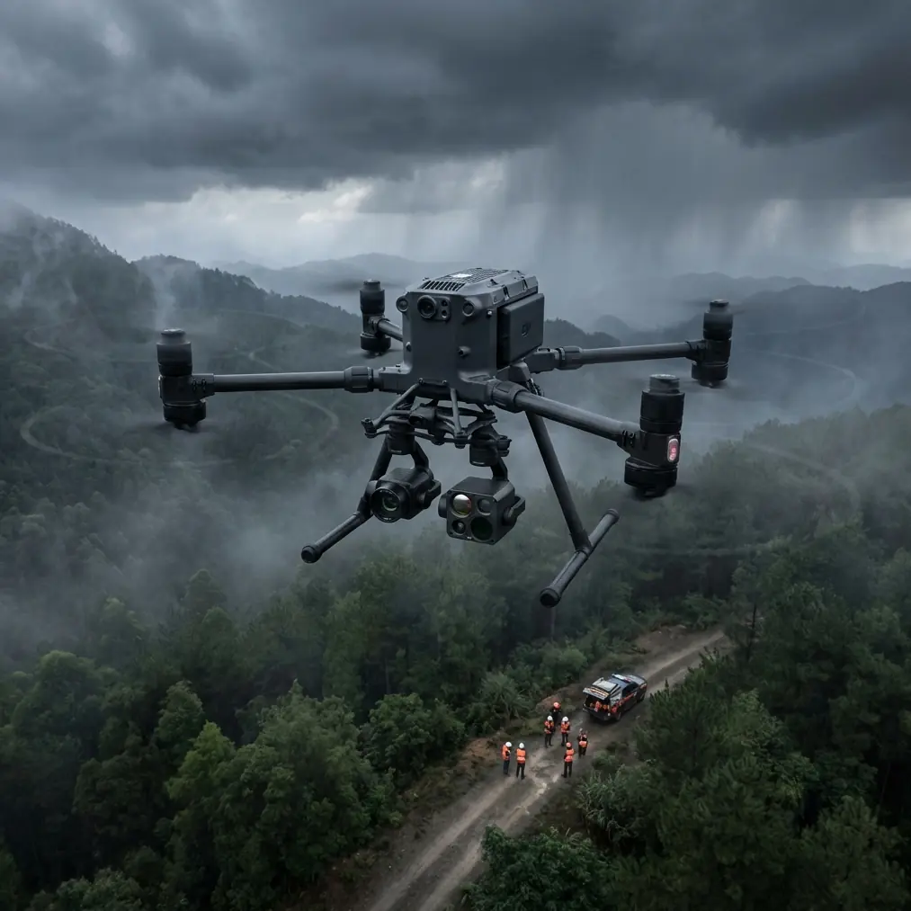
Why the Matrice 400 matters in this mission profile
The Matrice 400 sits in the class of aircraft operators choose when the mission is operational, not recreational. Highway delivery in low light usually means balancing three things at once: route endurance, obstacle awareness, and dependable command-and-control over a stretched corridor. That is where the platform’s design priorities become more than spec-sheet trivia.
Take hot-swap batteries. On paper, it sounds like a convenience feature. In practice, it changes how a delivery team manages sortie tempo. When you are moving goods or critical parts between highway-adjacent points in a narrow operating window, battery replacement speed affects dispatch rhythm, crew fatigue, and aircraft availability. Hot-swap support reduces downtime between flights and helps the team preserve continuity during repetitive operations. That matters even more at night, when every extra minute on the ground can mean drifting into a less favorable weather or traffic pattern.
Then there is O3 transmission. In a low-light highway corridor, a stable long-range link is not just about pilot comfort. It directly affects whether the crew can monitor route health, payload status, and camera feeds with enough confidence to continue or divert. Highway environments produce their own complexity: moving RF sources, large metal structures, changing terrain edges, and signal interruptions caused by overpasses or roadside infrastructure. A robust transmission system gives the remote crew more usable decision time before a small issue becomes a mission abort.
Security also deserves more attention than it usually gets in drone articles. If your operation involves deliveries, route data, infrastructure imagery, or customer handoff points, protecting the data stream matters. AES-256 encryption is not a decorative acronym. It is operational hygiene for teams that need to move sensitive location and mission information through a commercial workflow without exposing unnecessary risk.
Step 1: Build the route around what low light hides
Highways look simple from above. They are not.
Start with a corridor survey in daylight and gather your route intelligence before the low-light mission. This is where photogrammetry still earns its place, even if your end mission is delivery rather than mapping. A current surface model and orthomosaic can reveal construction changes, temporary barriers, vegetation encroachment, sign gantries, and alternate emergency landing areas. If you need repeatable accuracy for route verification or takeoff and delivery zone validation, use GCPs where appropriate during your survey workflow. Ground control points give your map products tighter positional confidence, which helps when you are comparing planned versus real conditions around highway infrastructure.
That matters because low light removes the pilot’s margin for casual correction. In broad daylight, a crew may notice a newly installed overhead cable or a reconfigured shoulder access point visually and adapt. In low light, you want those surprises found in the planning phase, not on final approach.
A practical pattern is to map the route segment first, then break it into operational zones:
- Launch and recovery area
- Transit corridor
- Delivery handoff area
- Alternate landing sites
- Communication weak spots
- Thermal anomaly zones such as recently paved sections or industrial rooftops nearby
This zoning becomes the backbone of your SOP. It also gives the visual observer and remote pilot a common language during flight.
Step 2: Use thermal intelligently, not as a substitute for planning
Thermal signature work is particularly useful in low-light highway delivery, but crews get the most value from it when they understand what thermal can and cannot do. A thermal view can help separate vehicles, people, active machinery, and heat-retaining surfaces from a darker background. It can reveal whether a shoulder area is occupied before descent. It can also help identify unexpected heat sources along the route, such as maintenance equipment or recently used staging zones.
But thermal interpretation over highways requires discipline. Pavement stores heat unevenly. Concrete barriers, metal signage, engine blocks, rooftops, and drainage structures all behave differently as temperatures fall. A hotspot is not automatically a hazard, and a cool area is not automatically empty. Use the thermal feed as a second layer of awareness, not the only one.
For delivery work, one of the best uses of thermal is confirming the final approach environment. If the drop or handoff zone sits near a service road, laydown yard, toll infrastructure, or utility shoulder, the thermal camera can quickly reveal whether the area is truly clear. This is especially valuable when visible light is compromised by glare from vehicle headlights or patchy roadside lighting.
Step 3: Treat connectivity as part of flight safety
O3 transmission is often discussed in terms of range and video quality. For actual highway missions, the more useful perspective is continuity. A low-light route is not the place to discover hidden dead zones. Conduct a link assessment before routine operations begin. Fly the corridor in controlled test conditions and identify where terrain, roadside structures, or RF noise affect command or video stability.
Document those points. Then build route rules around them.
For example, if one bridge approach consistently reduces signal quality, do not wait until a live delivery to improvise. Raise route altitude if regulations and environment allow, reposition the crew station, or segment the mission with a handoff procedure. The Matrice 400’s communication capability is a strength, but it still benefits from intelligent route design.
If your organization is scaling toward BVLOS workflows where regulations and approvals permit, these pre-mapped communication behaviors become even more important. BVLOS is never just about distance. It is about proving predictability. Stable route geometry, known signal behavior, clear contingency logic, and secure data handling all support that progression.
Step 4: Make battery transitions boring
Boring is good when it comes to power management.
Hot-swap batteries are one of those features that can either improve operations or encourage sloppiness, depending on crew discipline. The right approach is to standardize battery handling so the transition is repeatable every time. Label battery pairs, track cycle health, record temperature, and define minimum return thresholds that account for night conditions and corridor wind.
Highways can create deceptive microclimates. Open stretches may present stronger crosswinds than expected, while embankments and structures can create turbulence near delivery points. At low light, judging these effects visually is harder. Conservative power planning is not wasted margin; it is the buffer that keeps an ordinary delivery from becoming a rushed recovery.
During battery swaps, inspect contacts and seating surfaces. Dust and moisture contamination around the battery interface can produce intermittent issues that are avoidable with a disciplined check. Again, this ties back to cleaning. Clean aircraft, clean sensors, clean battery interfaces. It is not glamorous, but it is the kind of routine that prevents avoidable failures.
Step 5: Secure the mission data, not just the aircraft
Delivery teams sometimes focus so heavily on airworthiness that they overlook information security. Yet a low-light highway mission can involve route files, client locations, infrastructure imagery, cargo details, and operational schedules. With AES-256 protecting the transmission environment, the Matrice 400 supports a stronger security posture than a casual setup would provide.
Operationally, that means you should align your workflow with the platform’s security strengths. Restrict route file access, manage media export procedures, and define who can view live feeds during active missions. If a mission includes sensitive infrastructure or customer property, that matters. Secure transmission is most useful when the rest of the workflow is equally disciplined.
Step 6: Rehearse the handoff zone before you ever carry payload
A low-light delivery mission should not begin with a real delivery. Rehearse the route and endpoint first with a non-operational payload or training configuration. The goal is not just to confirm navigation. It is to understand how the aircraft, camera views, and crew communications behave when approaching the handoff point under realistic lighting conditions.
Watch for three things:
- Depth perception issues near the delivery site
- Thermal confusion from nearby vehicles, lighting, or retained surface heat
- Obstacle visibility changes caused by glare or shadow pockets
This is where a specialist can save time. If your team wants a second set of eyes on route design or payload integration choices, you can share your mission scenario here: send the corridor details for a practical review.
Step 7: Write abort logic that fits the highway environment
Abort criteria should be decided before takeoff and written plainly. Not hidden in someone’s head.
For low-light highway delivery, the most useful abort triggers are usually tied to visibility quality, sensor confidence, link continuity, wind behavior at the handoff area, and uncertainty in the final landing or release environment. If the approach zone cannot be positively verified, stop. If the thermal image becomes ambiguous because of glare, retained pavement heat, or unexpected traffic movement, stop. If signal quality drops at a known weak point outside your tested margin, stop.
That may sound strict, but repeatable commercial operations are built on consistency. The Matrice 400 is valuable because it supports that consistency across sensing, transmission, power workflow, and secure communications. The platform helps; the SOP makes it real.
The practical takeaway
A lot of drone content treats advanced aircraft as if mission success comes from buying the right machine. Real operators know better. For low-light highway delivery, success comes from stacking small certainties until the whole mission becomes predictable.
Clean the sensing surfaces before power-on. Use photogrammetry and GCP-backed planning to remove route surprises. Lean on thermal signature analysis where it adds clarity, especially near the final approach, but do not mistake it for omniscience. Validate O3 transmission behavior across the actual corridor. Use AES-256 as part of a genuine security workflow, not just a feature mention. Make hot-swap battery procedures standardized and dull. If BVLOS is part of your future, build the habits now that make predictability provable later.
That is how the Matrice 400 becomes more than a capable aircraft. It becomes a dependable tool for a very specific job: moving through long, visually difficult highway environments when the light is working against you.
Ready for your own Matrice 400? Contact our team for expert consultation.