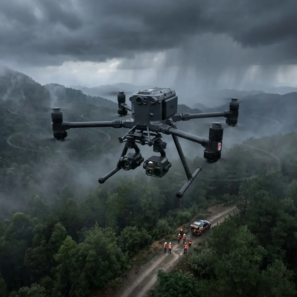
Matrice 400 for Mountain Highways: A Field Tutorial
Matrice 400 for Mountain Highways: A Field Tutorial from Pre-Flight Cleaning to Reliable Delivery Routes
META: Expert tutorial on using the Matrice 400 for mountain highway delivery, inspection, and low-altitude logistics, with practical guidance on pre-flight safety, transmission reliability, thermal workflows, and BVLOS-ready planning.
Mountain highways expose every weak link in an unmanned workflow.
Wind funnels through cut slopes. Dust builds around retaining walls and bridge joints. GNSS conditions can change between a tunnel entrance, a steep valley, and an exposed ridgeline. If the mission is not just to inspect the corridor but to support delivery along it, the aircraft has to do more than fly well. It has to carry useful payloads, maintain stable links over uneven terrain, and fit into a repeatable operating system that crews can trust.
That is why the Matrice 400 deserves attention in this specific context.
The broad industry signal behind heavy-lift platforms is already clear. Recent reporting from huanqiu_uav pointed to DJI’s release of two high-payload drones as part of building what it described as a new productive force for the low-altitude economy. That language matters because it frames these aircraft not as niche tools, but as infrastructure enablers. For mountain highways, that shift is practical, not rhetorical. A capable transport and data-collection drone changes how road operators move urgent parts, surveying teams reach inaccessible segments, and maintenance planners understand changing slope conditions.
This tutorial is built around that operational reality: how to prepare a Matrice 400 workflow for mountainous highway delivery and corridor support, starting with one often-overlooked step—pre-flight cleaning.
Why mountain highway missions are different
A flat industrial park is forgiving. A mountain road is not.
Highway teams working in elevated terrain typically face four overlapping demands:
Route complexity
A simple point-to-point line on a map may cross ridges, drop into ravines, and pass structures that complicate radio performance.Payload practicality
The mission often includes moving tools, small emergency parts, medical kits for worker support, sensors, or documentation equipment between staging points.Inspection overlap
Delivery flights often benefit from simultaneous visual review of pavement edges, barriers, drainage channels, bridge approaches, and unstable slopes.Time pressure
When a crew is waiting for a replacement component several kilometers away on a mountain section, slow ground transport can turn a minor maintenance issue into a costly shutdown.
Heavy-lift drones are relevant here because they expand what “useful” means in low-altitude operations. The source material emphasizes the wider rollout of next-generation high-payload transport UAVs serving industry and public livelihood at a higher level and across broader scenarios. In mountain highway work, that translates into a platform that can support both logistics and data capture rather than forcing operators to choose one or the other.
Start with cleaning, not calibration
Pilots often jump straight to battery status, route review, and payload checks. On mountain highway jobs, I recommend a cleaning step before everything else.
Not a cosmetic wipe-down. A deliberate safety cleaning.
The pre-flight cleaning routine I want crews to follow
Before powering the Matrice 400:
- Wipe dust and fine grit from vision and obstacle sensing surfaces.
- Inspect payload connectors for road dust, moisture residue, and grit contamination.
- Clean camera glass, thermal windows, and any rangefinding surfaces with approved tools only.
- Check landing gear contact areas and underside surfaces where mud or gravel spray may have accumulated.
- Inspect battery bays and contacts for contamination before inserting hot-swap batteries.
Why begin here? Because mountain highways generate exactly the kind of contamination that quietly degrades safety systems. Trucks throw particulate matter into the air. Fresh rock-cut sections produce fine abrasive dust. Fog and light drizzle can leave residue that attracts dirt. A sensor suite does not have to fail completely to create risk; it only has to become less reliable when the aircraft is navigating near guardrails, cut slopes, sign gantries, or bridge edges.
This is also where thermal signature work can be compromised. If you are using thermal data to spot overheating electrical boxes, friction anomalies in roadside equipment, or heat patterns near drainage infrastructure, a dirty optical path can reduce confidence in what you see. One minute of cleaning can prevent one hour of false interpretation.
I treat this step as part of the airworthiness check, not housekeeping.
Build the mission around terrain, not just distance
Operators planning highway support flights in mountains tend to fixate on route length. Distance matters, but terrain is usually the bigger variable.
A Matrice 400 deployment should begin with a corridor logic:
- Identify launch and recovery points with clear vertical escape space.
- Map likely RF shadow zones created by cliffs, overpasses, retaining walls, and bends.
- Separate delivery legs from data-collection legs if the payload or timing makes one interfere with the other.
- Mark emergency divert sites near maintenance lay-bys, toll plazas, service turnouts, or stable roadside clearings.
This is where O3 transmission becomes more than a spec-sheet term. In mountain highway work, robust transmission is operationally significant because terrain can break line quality long before crews visually appreciate the problem. A stronger transmission architecture supports better command continuity and live situational awareness when the aircraft is moving through uneven topography. That is especially useful when a route passes from open valley air into partially shielded roadway sections.
For teams preparing future BVLOS operations where regulations and local approvals allow, route discipline becomes even more important. BVLOS on a mountain corridor is not simply “farther than visual line of sight.” It is a structured operating environment requiring terrain-aware planning, communication procedures, alternates, and conservative decision gates.
Delivery is only half the value
A Matrice 400 assigned to mountain highways should not be treated as a flying parcel hook with a premium airframe attached. The stronger play is to combine logistics support with infrastructure intelligence.
Imagine a maintenance team replacing drainage hardware after a storm event. The aircraft can deliver the required part to a mountain service point, then pivot into a slope and roadside condition check on the return leg. That is where photogrammetry and thermal review enter the workflow.
Photogrammetry on a highway corridor
Photogrammetry is especially useful for:
- Tracking slope movement indicators over time
- Measuring erosion near shoulders and culverts
- Updating 3D context around bridges, barriers, and cut sections
- Documenting post-landslide cleanup progress
If you need dependable spatial outputs, use GCPs where practical. Ground control points matter because highway corridors in mountainous areas often produce inconsistent geometry if the mission relies only on onboard positioning. GCPs tighten confidence in deliverables when engineers need data they can use for comparison, planning, or contractor verification.
That is one of the most underappreciated operational distinctions in drone highway work: pretty imagery is not the same as decision-grade data. GCP-backed photogrammetry gets you closer to the latter.
Thermal signature in mountain operations
Thermal signature analysis adds another layer. In this environment, it can help teams examine:
- Electrical cabinets and roadside power systems
- Drainage outlets affected by temperature contrast
- Moisture retention patterns on unstable slopes
- Bridge deck or structural areas showing unusual thermal behavior
Again, the significance is practical. A logistics-capable platform that can also gather thermal evidence reduces the number of site visits needed in difficult terrain. That saves time, lowers exposure for crews, and makes route planning more efficient across long mountain corridors.
Why hot-swap batteries matter on highway jobs
Battery changes are routine, but on mountain highways they shape the whole tempo of work.
Hot-swap batteries are operationally valuable because field teams often cannot afford long reset cycles at temporary roadside staging points. Weather windows can be narrow. Traffic control arrangements may be limited. A crew might have only a short access period to launch from a safe pull-off. The ability to swap power efficiently keeps the mission moving and helps preserve continuity between delivery, inspection, and mapping tasks.
That continuity matters even more when the drone is supporting active maintenance. If a crew is waiting on a delivered component, every avoidable delay stretches downtime.
Battery handling, though, brings us back to cleaning. Dust or moisture contamination around battery bays is not a trivial issue in mountain environments. If you are relying on rapid battery turnaround, contact inspection and bay cleanliness have to be procedural, not optional.
Security is not abstract in infrastructure corridors
Mountain highways are infrastructure assets. Data from them can include imagery of tunnels, bridges, utility interfaces, and maintenance patterns. If a Matrice 400 operation is transmitting operational video, inspection results, or route data, security has to be built in.
That is why AES-256 support deserves mention. Encryption is operationally significant because it helps protect transmitted data in environments where infrastructure imagery and live mission feeds may have real sensitivity for contractors, operators, and public agencies. Even in civilian work, secure transmission is not a luxury. It is part of professional standards.
This becomes more relevant when multiple stakeholders are involved: road authority teams, engineering consultants, mapping contractors, and maintenance vendors. If the drone is becoming part of the low-altitude economic fabric described in the source reference, then secure information handling is part of what makes that ecosystem viable at scale.
A sample mountain highway workflow for the Matrice 400
Here is the field sequence I would teach a crew.
1. Site arrival and environmental read
Assess wind channeling, dust conditions, local obstacles, traffic disturbance, and possible emergency landing areas.
2. Pre-flight cleaning
Clean sensing surfaces, camera optics, thermal windows, payload mounts, landing gear, and battery interfaces. This is a safety task.
3. Aircraft and payload verification
Confirm airframe integrity, payload lock, firmware consistency, battery condition, and mission profile alignment.
4. Transmission assessment
Review expected O3 link quality along terrain transitions. Identify likely dead zones and route adjustments before takeoff.
5. Delivery leg planning
Balance altitude, terrain clearance, and arrival precision. Keep the route conservative if road geometry creates signal masking.
6. Return-leg inspection tasking
If the aircraft is returning without cargo, assign useful work: thermal scan, image capture, photogrammetry strip, or spot-check of problem areas.
7. Data integrity review
After landing, verify image quality, thermal clarity, geospatial completeness, and any GCP tie-in before the crew demobilizes.
8. Battery turnaround and relaunch decision
Use hot-swap procedures carefully, inspect battery bays again, and relaunch only if weather, visibility, and corridor conditions still support safe execution.
Where this fits in the low-altitude economy discussion
The source text makes a broad claim: new-generation heavy-payload transport UAVs will serve industries and public livelihood across wider spaces and at a higher level. Strip away the policy phrasing, and the field meaning becomes clear. These aircraft are useful when they connect real work sites, real constraints, and real consequences.
Mountain highways are an excellent example.
They are long linear assets with persistent maintenance needs. They cut across terrain that makes ground movement inefficient. They demand inspection, documentation, and logistics support almost continuously. A platform like the Matrice 400 fits not because “drones are the future,” but because this is exactly the kind of corridor where low-altitude productivity becomes measurable.
Less waiting for parts. Faster assessment after weather damage. Better repeatability in mapping. Safer access to difficult segments. Tighter coordination between engineering and maintenance teams.
That is what the low-altitude economy looks like when it leaves the headline and reaches the shoulder of a mountain road.
A final practical note for teams deploying soon
If you are preparing a Matrice 400 workflow for highway operations, resist the urge to overcomplicate the first deployment. Start with one corridor, one repeatable pre-flight cleaning standard, one delivery profile, and one return-leg inspection objective. Build discipline before scale.
I also recommend documenting your cleaning checklist with photos from the actual site environment. Teams are far more likely to follow sensor-cleaning protocols when they can see how quickly mountain dust coats optics and connectors during normal operations.
And if your team is still deciding how to structure route design, payload integration, or corridor communications, it helps to discuss it with someone who has seen these workflows in the field. You can share your scenario here: message Dr. Lisa Wang’s team on WhatsApp.
The Matrice 400 is most valuable when treated as part aircraft, part logistics node, and part data platform. On mountain highways, that combination is not theoretical. It is exactly what makes the mission work.
Ready for your own Matrice 400? Contact our team for expert consultation.