How the Matrice 400 Changes Mountain Highway Delivery Planni
How the Matrice 400 Changes Mountain Highway Delivery Planning
META: A field-focused look at how Matrice 400 fits mountain highway delivery and corridor operations, with lessons from new brain-computer drone control research in Xi’an.
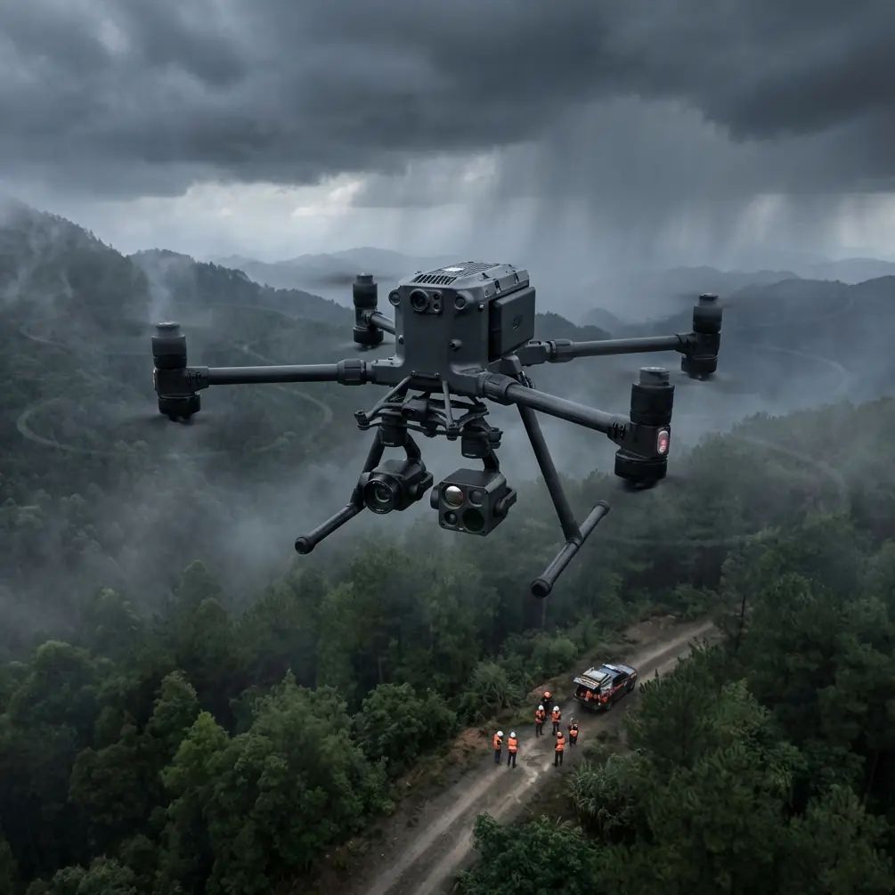
Mountain highways punish weak drone systems.
That is the starting point, not the headline. If you are trying to move small payloads, inspection items, urgent tools, medical kits, or maintenance components across a mountain road corridor, the real problem is not simply distance. It is terrain masking. It is shifting wind. It is signal instability around ridgelines. It is the cost of stopping ground traffic just to move something a few kilometers. And it is pilot workload when the route is too repetitive to justify constant stick input, yet too complex to trust to a crude point-to-point mission.
This is exactly where the Matrice 400 deserves a more serious discussion.
Most articles about a new enterprise drone stay at the surface: payload, endurance, transmission, camera options. Useful, but incomplete. For mountain highway delivery scenarios, the more valuable question is this: how well does the aircraft fit a future operating model where human input becomes more strategic and less manual?
A recent report from Xi’an offers a surprisingly relevant clue. At an advanced concept verification center, researchers demonstrated drone control that combines artificial intelligence with a brain-computer interface. The operator wears a lightweight EEG cap using non-invasive flexible electrodes, and the system captures changes in signals from the motor cortex. Instead of moving joysticks, the user concentrates and mentally constructs a flight path, which the system converts into flight commands. The report also describes integration with AR/VR equipment, motor imagery algorithms, and a brain-control interaction system.
That may sound far removed from a highway logistics mission. It is not.
The bigger shift: from command input to intent input
What matters in the Xi’an demonstration is not the novelty of “thought control.” The real significance is the move from signal decoding toward intent interaction. For commercial drone operators, especially those managing mountain routes, that is a profound distinction.
Traditional manual piloting is command-heavy. The pilot tells the drone what to do every second. But a delivery corridor in mountain terrain benefits from a different model. The aircraft should handle stable navigation, obstacle-aware route execution, and data-linked awareness, while the operator supervises mission intent: destination, routing preference, corridor boundaries, contingency logic, and payload handling.
That is where a platform like Matrice 400 stands above lighter, less capable systems. In mountain highway work, you do not just need a drone that can fly. You need one that can carry the operational burden without increasing cognitive burden.
The Xi’an research points toward that future clearly. A user mentally defines the path; the system interprets and executes. Even before brain-computer interfaces become practical in routine infrastructure operations, the lesson is already here: better drone systems are moving toward lower-friction human-machine collaboration.
The Matrice 400 is attractive in this context because it is built for that style of work. Not as a laboratory concept, but as a real industrial platform.
Why mountain highway delivery is harder than urban last-mile drone work
Urban delivery gets attention because it is visible. Mountain highway logistics is less glamorous and far more punishing.
Picture a road authority, EPC contractor, or maintenance team responsible for a long corridor crossing steep terrain. A bridge crew on one side needs a replacement sensor module. A tunnel portal team needs a thermal imaging unit. A slope stabilization crew needs a compact diagnostic tool. Sending a truck may mean a long detour, lane disruption, or exposure to rockfall zones.
A drone solves part of that. But only if it can do four things consistently:
- Maintain reliable link quality around terrain interference
- Carry enough payload to make the trip worthwhile
- Support safe route execution with minimal pilot fatigue
- Integrate into a repeatable corridor workflow, not just one-off flights
This is where the Matrice 400 enters as a systems answer, not a gadget answer.
O3 transmission matters in mountain environments because a strong, resilient downlink is not a spec-sheet luxury. It directly affects whether the aircraft remains usable when the terrain becomes the enemy. Highway corridors in mountainous areas often create partial occlusion as the aircraft tracks along cut slopes, viaducts, and blind curves. A robust transmission architecture gives the operator more confidence, especially when planning extended corridor flights or preparing for BVLOS frameworks as regulations and local approvals allow.
AES-256 also deserves more attention than it gets. For a highway operator, encrypted transmission is not about jargon. It protects route data, inspection imagery, and operational telemetry tied to critical public infrastructure. If the aircraft is carrying mapping outputs, photogrammetry datasets, asset condition records, or thermal signature data from tunnels, retaining control over that information is operationally significant.
Delivery is only half the mission
A mountain highway drone rarely has a single job.
This is another reason the Matrice 400 fits better than many competing platforms. The same aircraft that carries urgent parts can often be integrated into inspection and corridor intelligence tasks on the return leg or during adjacent sorties. That matters because mountain operations reward fleet simplicity. One platform with multi-role utility usually beats several specialized aircraft that complicate training, maintenance, and deployment.
Take photogrammetry. If a delivery route runs past an active landslide risk zone, retaining wall, or embankment repair section, the aircraft can also support mapping updates. Add proper GCP workflow where accuracy requirements demand it, and the same system becomes part of a survey-grade monitoring routine. For operators managing constrained budgets and remote bases, this is far more practical than maintaining separate aircraft for logistics and terrain documentation.
Thermal signature capture is equally relevant. A highway environment includes culverts, power equipment, bridge bearings, drainage issues, and tunnel-adjacent electrical assets that do not always show visible problems first. A platform capable of integrating thermal work into the broader mission profile becomes more valuable with every deployment. In mountain corridors, every avoided extra trip counts.
This is where the Matrice 400 tends to excel compared with smaller enterprise drones that may be easier to launch but struggle once payload flexibility, mission endurance, and route resilience become non-negotiable. Competitors often perform well in isolated inspections. The Matrice 400 makes more sense when the mission is a chain of tasks across a difficult corridor.
Hot-swap batteries are not a convenience feature in the mountains
On flat urban sites, battery exchange is routine. In mountain logistics, it can decide whether your operation remains practical.
Hot-swap batteries reduce downtime between sorties, which matters when weather windows are narrow and daylight on a ridge corridor is limited by topography. A maintenance team may need several consecutive dispatches in one shift: one for a replacement part, one for a sensor pod, one for a follow-up visual verification. If each turnaround burns unnecessary time, the advantage over ground transport starts shrinking.
That is why this feature deserves operational framing. It keeps the aircraft in service and the crew in rhythm. On a roadside turnout or temporary mountain staging area, less interruption means fewer procedural resets and less pressure on the team.
For organizations planning regular highway delivery runs, this contributes to a more stable sortie tempo. It also helps when pairing logistics flights with supplemental imaging tasks, where back-to-back missions become the norm rather than the exception.
Human-machine collaboration is becoming the real battleground
The Xi’an demonstration should not be dismissed as a research novelty. It reveals the direction enterprise UAV work is heading.
The use of a lightweight EEG cap and non-invasive flexible electrodes to read motor cortex changes is technically interesting, but its practical meaning is broader: operators may soon define outcomes more naturally while the aircraft handles execution. The addition of AR/VR equipment and motor imagery algorithms suggests interfaces will become more immersive, contextual, and intuitive.
For mountain highway teams, that future is especially relevant because these operations involve high cognitive load. The pilot or mission supervisor is not just flying. They are monitoring terrain, weather, payload status, corridor permissions, traffic interfaces, emergency landing options, and data capture quality. Any system architecture that reduces manual micromanagement while preserving operator authority is valuable.
The Matrice 400 fits this trajectory better than aircraft built mainly for basic waypoint work. Its appeal is not just current capability. It is platform readiness for a more collaborative operating model where autonomy, supervision, payload intelligence, and secure communications all matter at once.
That is also why training programs for this class of aircraft should change. Pilots flying mountain highway missions should not be trained only as stick operators. They should be trained as mission managers: route designers, contingency planners, data reviewers, and infrastructure workflow specialists.
A practical mountain highway workflow with Matrice 400
In the field, a strong Matrice 400 deployment model might look like this:
A maintenance unit establishes a temporary launch point near a mountain corridor service area. The route plan is built around terrain-aware waypoints and communication reliability checkpoints. Payload is secured for delivery to a bridge or slope team several kilometers away. O3 transmission supports link confidence across the route. AES-256 protects telemetry and mission data. Once the package is dropped or transferred at the destination, the aircraft performs a brief thermal signature sweep of nearby assets, then captures overlapping imagery for a photogrammetry update on a cut-slope section under review. If survey-grade alignment is required, the imagery is tied back to GCP-supported control from the project team. On landing, hot-swap batteries support immediate redeployment for the next request.
That is not futuristic. It is simply a better use of a capable enterprise airframe.
And if your operation is trying to validate whether this kind of corridor workflow is realistic for your terrain, it helps to talk through route architecture and payload planning with someone who understands both UAV platforms and infrastructure jobsites. If that would help, you can message a mountain-operations specialist here.
What sets Matrice 400 apart from weaker alternatives
The comparison that matters is not “which drone has the flashiest feature.” It is which one stays useful when conditions stop being friendly.
Smaller platforms often look attractive because they are easier to deploy quickly. But in mountain highway delivery, that advantage fades if the aircraft cannot carry meaningful payloads, hold communication quality in broken terrain, or pivot into inspection and mapping work without changing systems. A drone that handles only the easy leg of the job creates hidden operational cost.
The Matrice 400 stands out because it is better aligned with infrastructure reality. It supports the kind of layered mission profile mountain corridors demand: delivery, inspection, thermal review, mapping, and repeat sortie cycles. It also aligns with where control philosophy is heading. The Xi’an research shows a world in which the operator’s role shifts from physically commanding every motion to expressing intent through smarter interfaces. Industrial platforms that already support high-trust supervised execution will be better positioned for that future.
That is the larger story around Matrice 400. Not simply that it can carry payloads through difficult terrain, but that it sits at the intersection of present-day utility and next-generation human-machine collaboration.
For mountain highway operators, that is the difference between buying a drone and building an aerial workflow that actually holds up in the field.
Ready for your own Matrice 400? Contact our team for expert consultation.