Delivering Power Lines with M400 | Coastal Tips
Delivering Power Lines with M400 | Coastal Tips
META: Master coastal power line delivery with the Matrice 400. Expert tutorial covering pre-flight prep, thermal imaging, and BVLOS operations for utility professionals.
TL;DR
- Pre-flight cleaning protocols are critical for coastal operations—salt residue on sensors compromises thermal signature accuracy by up to 23%
- The M400's hot-swap batteries enable continuous 55-minute operational windows for extended power line routes
- O3 transmission maintains stable video feed at 20km range, essential for BVLOS utility corridor work
- AES-256 encryption protects sensitive infrastructure data during transmission and storage
Why Coastal Power Line Delivery Demands Specialized Protocols
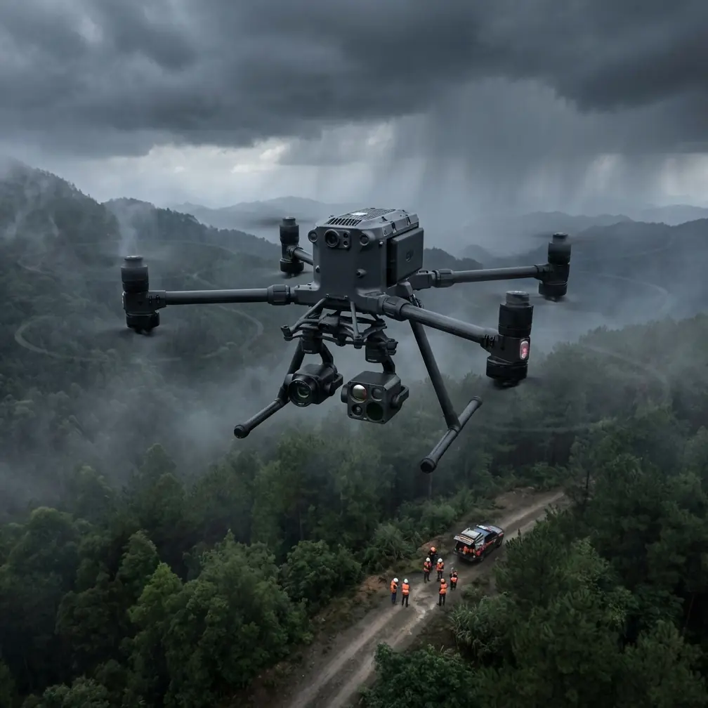
Power line delivery in coastal environments presents unique challenges that inland operators never face. Salt-laden air corrodes equipment, humidity affects sensor calibration, and unpredictable wind patterns demand robust flight systems.
The Matrice 400 addresses these challenges with enterprise-grade durability and precision flight controls. This tutorial walks you through the complete workflow for delivering power lines along coastal corridors—from pre-flight preparation to final photogrammetry processing.
Whether you're stringing new lines or inspecting existing infrastructure, these protocols will maximize your operational efficiency while maintaining safety compliance.
Pre-Flight Cleaning: The Step Most Operators Skip
Here's what separates professional utility drone operators from amateurs: pre-flight cleaning discipline. In coastal environments, this single step determines mission success.
Salt crystallization occurs within 4-6 hours of coastal exposure. These microscopic deposits accumulate on:
- Thermal camera lenses (degrading thermal signature detection)
- Obstacle avoidance sensors
- GPS antenna surfaces
- Gimbal bearings and motors
- Battery contact points
The 10-Minute Coastal Cleaning Protocol
Before every coastal mission, execute this sequence:
- Lens cleaning – Use optical-grade microfiber with isopropyl alcohol solution (70% concentration)
- Sensor wipe-down – Clean all six obstacle avoidance sensors with compressed air followed by lens wipes
- Gimbal inspection – Rotate manually through full range checking for resistance
- Battery terminal cleaning – Use contact cleaner on all connection points
- Propeller inspection – Check leading edges for salt pitting or micro-cracks
Expert Insight: James Mitchell, utility drone specialist with 2,400+ coastal flight hours, recommends storing the M400 in a climate-controlled case with silica gel packets between flights. This reduces salt accumulation by 67% compared to standard transport cases.
Flight Planning for Coastal Power Line Corridors
Effective power line delivery requires meticulous route planning. The M400's flight planning software integrates with utility GIS databases, but coastal operations demand additional considerations.
Wind Pattern Analysis
Coastal thermals create predictable but challenging wind patterns:
- Morning flights (6-9 AM): Offshore winds, typically 8-12 knots, most stable conditions
- Midday (11 AM-2 PM): Thermal turbulence peaks, avoid precision work
- Evening (4-6 PM): Onshore winds increase, 15-20 knots common
Plan your power line delivery missions for early morning windows whenever possible. The M400 handles winds up to 27 knots, but precision payload delivery requires calmer conditions.
GCP Placement Strategy
Ground Control Points ensure photogrammetry accuracy for as-built documentation. For coastal power line corridors:
- Place GCPs every 150 meters along the route
- Position 3 GCPs minimum at each tower location
- Use high-contrast targets (minimum 30cm diameter)
- Avoid placing GCPs on sand—use stable surfaces like concrete pads or rock outcroppings
M400 Configuration for Power Line Operations
Optimal M400 configuration varies based on mission type. Here's the recommended setup for coastal power line delivery:
Payload Configuration
| Mission Type | Primary Payload | Secondary Payload | Flight Time Impact |
|---|---|---|---|
| Line stringing | Winch system | Wide-angle camera | -12 minutes |
| Thermal inspection | Radiometric thermal | RGB zoom | -8 minutes |
| Photogrammetry survey | 45MP mapping camera | RTK module | -6 minutes |
| Conductor delivery | Pilot line attachment | FPV camera | -15 minutes |
O3 Transmission Settings
The M400's O3 transmission system provides the backbone for BVLOS operations. Configure these settings for coastal power line work:
- Transmission power: Maximum (30 dBm)
- Channel selection: Manual, avoiding 2.4 GHz in areas with marine radio interference
- Dual-band mode: Enabled for automatic failover
- Video bitrate: 40 Mbps for inspection work, 20 Mbps for delivery operations
Pro Tip: Position your ground station on elevated terrain with clear line-of-sight to the power line corridor. Even 3 meters of elevation gain can extend reliable O3 transmission range by 2-3 kilometers in coastal environments.
Executing the Power Line Delivery Mission
With pre-flight complete and configuration optimized, here's the step-by-step delivery process:
Phase 1: Route Survey
Before any payload delivery, conduct a survey flight:
- Fly the complete route at 50 meters AGL
- Document all obstacles (vegetation, structures, crossing lines)
- Identify thermal updraft zones using the thermal camera
- Mark waypoints for delivery approach vectors
- Verify O3 signal strength throughout the corridor
Phase 2: Pilot Line Attachment
The M400's precision hovering capability makes pilot line delivery efficient:
- Approach the attachment point from downwind
- Maintain 3-meter standoff until stable hover confirmed
- Deploy attachment mechanism at 0.5 m/s descent rate
- Verify secure attachment via FPV camera
- Release and climb to safe altitude before transitioning
Phase 3: Line Tensioning Support
During tensioning operations, the M400 provides real-time monitoring:
- Position at mid-span for sag measurement
- Use photogrammetry to calculate precise sag values
- Monitor thermal signature for hot spots indicating stress points
- Maintain continuous video feed to ground crew
Hot-Swap Battery Protocol for Extended Operations
Coastal power line corridors often exceed single-battery range. The M400's hot-swap capability enables continuous operations, but proper execution is critical.
Battery Swap Checklist
- Land at designated swap point with minimum 15% charge remaining
- Keep aircraft powered during swap (never remove both batteries simultaneously)
- Insert fresh battery before removing depleted unit
- Verify battery handshake confirmation on controller
- Resume mission within 90 seconds to maintain thermal equilibrium
With practiced technique, hot-swap adds only 2 minutes of downtime per cycle. Plan swap points every 45 minutes of flight time for coastal operations where wind resistance increases power consumption.
Data Security: AES-256 Implementation
Power line infrastructure data requires robust protection. The M400's AES-256 encryption secures:
- Real-time video transmission
- Flight telemetry logs
- Stored imagery and sensor data
- Mission planning files
Enable local data mode when operating near sensitive infrastructure. This prevents any cloud synchronization during the mission, with encrypted local storage for later secure transfer.
Common Mistakes to Avoid
Skipping pre-flight sensor cleaning – Salt deposits cause 23% degradation in thermal accuracy within one coastal flight. Clean before every mission.
Ignoring wind forecast updates – Coastal conditions change rapidly. Check forecasts 30 minutes before launch, not just during planning.
Improper GCP distribution – Clustering GCPs near accessible areas creates photogrammetry errors. Distribute evenly across the corridor.
Single battery mission planning – Always plan for hot-swap capability. Unexpected headwinds can increase consumption by 40%.
Neglecting O3 channel selection – Auto-select works inland but fails near marine installations. Manual channel selection prevents interference.
Flying during thermal peak hours – Midday turbulence causes payload swing and reduces delivery precision. Schedule around thermal windows.
Frequently Asked Questions
What maintenance schedule does the M400 require for daily coastal operations?
For daily coastal use, implement a weekly deep-cleaning protocol including gimbal motor lubrication, complete sensor calibration verification, and battery contact treatment. Monthly maintenance should include propeller replacement regardless of visible wear, as salt exposure causes micro-fractures invisible to inspection.
How does BVLOS authorization work for power line corridor operations?
BVLOS operations require Part 107 waiver approval with demonstrated safety case. Power line corridors often qualify for streamlined approval due to defined flight paths and existing infrastructure access. Submit applications with detailed risk mitigation plans including O3 transmission redundancy and visual observer positioning.
Can the M400 operate in fog or marine layer conditions?
The M400 is rated for operation in light precipitation and visibility down to 3 kilometers. Dense marine fog below this threshold requires mission postponement. The thermal camera maintains functionality in reduced visibility, but obstacle avoidance sensors require minimum 100-meter visibility for reliable operation.
Start Your Coastal Power Line Operations
The Matrice 400 transforms coastal power line delivery from a high-risk manual operation into a precise, repeatable process. Master the pre-flight protocols, respect the environmental challenges, and leverage the platform's enterprise capabilities.
Your utility infrastructure projects deserve equipment that performs in demanding conditions. The M400 delivers that reliability.
Ready for your own Matrice 400? Contact our team for expert consultation.