Matrice 400 for High-Altitude Power Line Delivery
Matrice 400 for High-Altitude Power Line Delivery: What Actually Matters in the Field
META: A technical review of how the Matrice 400 can support high-altitude power line delivery with thermal awareness, photogrammetry workflows, secure links, hot-swap endurance, and BVLOS-ready operational planning.
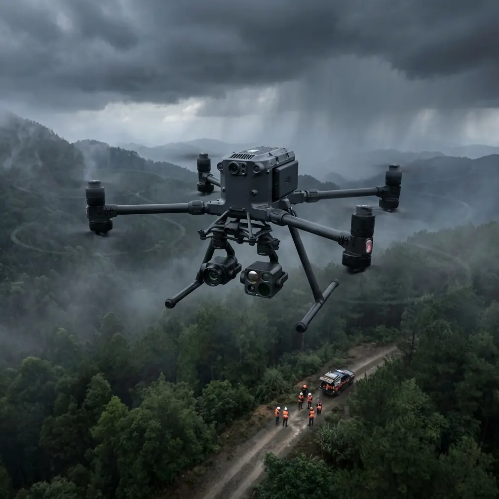
High-altitude power line work exposes every weakness in an aircraft, a payload stack, and the crew running it. Thin air steals lift. Mountain wind loads shift without warning. Cold temperatures drag down battery performance. Terrain blocks signal paths exactly when a pilot needs clean telemetry. That is why the right discussion around the Matrice 400 is not whether it looks capable on paper. The real question is whether its architecture supports repeatable delivery and inspection operations where utility corridors climb into ridgelines and weather windows stay narrow.
From that perspective, the Matrice 400 deserves a technical review built around one mission profile: delivering line tools or lightweight emergency components to power crews working at elevation, while also capturing actionable data during the same sortie set. That is a more demanding use case than ordinary corridor imaging. Delivery introduces weight management, route precision, hover stability, and much tighter risk margins around obstacles, wildlife, and energized infrastructure.
I approach this as an operator’s problem, not a brochure exercise. If you are evaluating the Matrice 400 for alpine or plateau transmission work, five areas matter most: endurance under cold-load conditions, transmission resilience, sensor usefulness beyond visual navigation, payload workflow design, and battery handling between consecutive launches.
The first operational reality is air density. At higher altitudes, a drone has to work harder to maintain the same lift and positional authority it would have near sea level. That changes the feel of the aircraft in a very practical way. Small corrections become more frequent. Hovering near towers or line access points demands more power reserve than teams often estimate during lowland testing. This is where a platform designed for enterprise payload operations has an advantage. The Matrice 400’s value is not just raw thrust; it is the ability to keep a predictable flight envelope once the mission stops being clean and controlled.
For power line delivery, predictability is worth more than headline speed. A drone carrying repair hardware or rope drops does not need to feel aggressive. It needs to hold a line in crosswind, descend precisely onto a preselected drop zone, and retain stable control when terrain forces the pilot into awkward approach angles. On mountain infrastructure jobs, I have seen otherwise capable aircraft begin to oscillate visually during final positioning because the route planning assumed open ground behavior. A utility crew does not care about spec-sheet elegance when a payload ends up five meters off target on a narrow service ledge.
This is also why hot-swap batteries are not just a convenience feature. They are a field uptime strategy. In remote transmission work, crews often operate from temporary staging points where generator capacity, charging shelter, and daylight are all constrained. If the Matrice 400 supports rapid battery replacement without a full aircraft shutdown, that reduces turn time and preserves mission continuity during narrow weather gaps. In practical terms, a hot-swap workflow means the aircraft can complete a short delivery run, land, exchange packs, and return for follow-up photogrammetry or thermal validation before the cloud ceiling collapses over the ridge. That is a serious operational advantage.
Cold weather compounds the issue. Battery chemistry is less forgiving at altitude, especially before the packs are fully warmed through active use. An aircraft that can be turned around efficiently helps crews avoid wasting precious charge stabilizing systems over long reboot cycles. For utility contractors handling multiple micro-missions in a shift, that kind of time savings accumulates fast.
Transmission is the second major question, and here the relevance of O3-class connectivity becomes obvious. Power line corridors in mountainous areas are terrible radio environments. You are not just dealing with distance. You are dealing with cliffs, vegetation transitions, steel structures, and line geometry that can interfere with visual and signal continuity. A robust O3 transmission link matters because it improves the odds of maintaining usable video and command responsiveness when the aircraft slips behind terrain contours or operates near complex infrastructure.
That becomes even more significant if your operational roadmap includes BVLOS permissions. BVLOS is not a magic label that makes difficult missions simple. It increases the need for disciplined route design, link planning, contingency mapping, and command integrity. If the Matrice 400 is being considered for future BVLOS corridor logistics or automated support flights, the aircraft’s transmission stack and its encryption posture deserve close scrutiny. AES-256 is not a decorative cybersecurity phrase in this context. Utility networks are critical infrastructure. Flight telemetry, route files, substation imagery, and corridor mapping data should not move across the air unprotected. Strong encryption supports compliance discussions, procurement confidence, and internal security review. That matters as much as flight performance when a power company is deciding whether to operationalize a new platform.
The third issue is sensor utility. A delivery aircraft assigned to power lines should not only move objects. It should also help crews interpret conditions around the route and landing area. This is where thermal signature awareness changes the quality of decision-making. In steep, cold environments, visual imagery can look deceptively clean while hiding problems that only appear in the thermal layer: overheating connectors, abnormal insulator heating patterns, or a recently energized component that changes how crews stage a handoff. A Matrice 400 configuration that supports useful thermal sensing can convert a simple delivery sortie into a mixed-value mission. The aircraft drops a needed item, then performs a quick verification pass that tells the ground team whether the visible condition matches the thermal condition.
That same thermal layer helps with wildlife avoidance, and this is not a theoretical concern. During one mountain corridor survey tied to a logistics run, the onboard sensing suite picked up a warm-bodied animal movement near a landing approach zone that the visual operator initially dismissed as brush motion. On closer review, it was a mountain goat moving across a narrow rocky shelf below the line. The aircraft held outside the final approach path, adjusted position, and delayed descent until the animal cleared the area. That kind of moment is easy to underestimate until you work in real terrain. Wildlife is not just an environmental note in a risk register. It can materially alter a delivery sequence, especially when rotor wash, confined landing geometry, and line proximity leave little margin for improvisation.
Photogrammetry is the fourth piece, and many teams still separate it too rigidly from logistics. They should not. If you are already flying a Matrice 400 into a high-altitude corridor, you have an opportunity to create a better spatial model of delivery access points, tower footing zones, and staging clearances. Photogrammetry supported by disciplined GCP placement can sharpen the reliability of route planning in a way that directly improves delivery safety. Ground control points are not glamorous, but they anchor the map to reality. In power line work, a few centimeters of elevation or offset error can be the difference between a smooth approach and an unnecessary hover correction near wires or hardware.
A good workflow looks like this: first, use the aircraft to collect corridor and approach imagery; second, tie the model with GCPs to produce dependable topographic context; third, define repeatable entry and exit paths for future delivery runs. Once that base map exists, crews can stop improvising around terrain memory and start operating from measurable geometry. That is how drone programs become dependable instead of merely impressive during demos.
There is also a deeper operational payoff. Photogrammetric models help identify safe alternate drop points when snow cover, erosion, or maintenance activity changes the original plan. They also support slope analysis, vehicle access planning, and line-of-sight assessments for relay or observer placement. For high-altitude power work, that means the Matrice 400 can contribute before, during, and after the actual payload movement.
The aircraft’s platform value, then, is not located in any single capability. It comes from stack integration. A secure O3 link supports control confidence. AES-256 helps answer infrastructure security concerns. Thermal signature interpretation adds diagnostic value and improves situational awareness. Hot-swap batteries reduce dead time. Photogrammetry plus GCP-backed mapping turns repeated delivery routes into engineered procedures rather than pilot intuition. If you are building a utility drone program that has to survive procurement review, safety audits, and field reality, that combination is what matters.
There are still caveats. No aircraft becomes altitude-proof because it carries an enterprise label. Teams should validate climb behavior, hover reserve, and battery derating at representative elevations instead of extrapolating from low-altitude tests. Payload rigging must be designed to avoid pendulum effects during final approach. Delivery routes should be written around terrain funnels and rotor wash interaction points, not simply shortest-path logic. A Matrice 400 can give a skilled team a stronger operating platform, but it will not rescue weak mission design.
Crew structure matters too. For demanding utility operations, the best results usually come from separating responsibilities clearly: pilot in command, payload or sensor operator, and a field coordinator who owns the handoff zone. That division becomes especially important when the mission blends delivery with thermal verification or mapping capture. Trying to compress all of that into one person’s attention span invites mistakes.
For organizations moving toward higher-maturity operations, this is also the moment to standardize data handling. Thermal files, route plans, GCP logs, and asset imagery should be captured in a way that maintenance and GIS teams can actually reuse. The Matrice 400 is most valuable when its output flows into the broader utility workflow instead of ending as isolated flight media on a field laptop. If you are refining that operational pipeline, it can help to compare deployment notes with teams already working similar terrain; one practical way to do that is through a quick field coordination chat here: message an operations specialist.
So where does that leave the Matrice 400 for high-altitude power line delivery? In my view, it sits in a very specific and useful category. Not a generic heavy enterprise drone. Not just an inspection platform with extra capacity. It is best understood as a multi-role utility aircraft whose real strength appears when logistics, sensing, and repeatable route planning are treated as one system.
That distinction matters because mountain power work punishes fragmented thinking. A drone that delivers well but maps poorly creates planning drag. A drone that maps well but lacks secure, resilient transmission creates operational hesitation. A drone with excellent sensors but awkward battery turnover loses tempo exactly when conditions narrow. The Matrice 400 makes sense if your program needs all of those layers to function together, especially where altitude amplifies every weakness.
For utility teams serving remote line crews, the future is not about sending a drone out for one isolated trick. It is about building an aerial workflow that can move a part, verify a thermal condition, document terrain, and come back ready for the next launch. That is the standard the Matrice 400 should be judged against. On that standard, it is a serious platform worthy of close evaluation.
Ready for your own Matrice 400? Contact our team for expert consultation.