Matrice 400 Guide for Mountain Power Line Delivery: Range
Matrice 400 Guide for Mountain Power Line Delivery: Range, Link Stability, and Payload Planning
META: Expert tutorial on using the Matrice 400 for mountain power line delivery, with practical advice on transmission reliability, antenna positioning, payload handling, and mission planning.
Mountain power line delivery is one of those jobs that looks simple on paper and turns complicated the moment terrain gets involved. A straight line on a map becomes a corridor of ridges, dead zones, shifting wind, and limited landing options. That is exactly why operators looking at the Matrice 400 need more than a feature checklist. They need a field-ready method.
If your mission is moving line-related materials, pilot ropes, light tools, or inspection payloads into steep transmission corridors, the aircraft itself is only part of the equation. The real work is in building a repeatable operating pattern around link integrity, battery transitions, route geometry, and what happens if the aircraft meets an unexpected obstruction in a confined mountain segment.
This guide is written for that scenario: delivering power lines in mountain terrain with the Matrice 400 as the platform at the center of the workflow.
Why mountain delivery missions are different
Power line work in mountains combines two jobs that are often treated separately: transport and infrastructure inspection. A single sortie may involve carrying a small delivery payload uphill, confirming line path clearance, checking tower approach conditions, and documenting terrain with photogrammetry for the next phase of work.
That blended role matters. It changes how you should configure the Matrice 400 before takeoff.
A normal lowland delivery route can often tolerate brief signal degradation or a less-than-ideal antenna angle. In mountain corridors, the terrain punishes those mistakes. Rock faces block line of sight. Towers and conductors introduce electromagnetic complexity. Wind can shear differently at the valley floor and ridge crest. If you are operating near the edge of visual range or planning a BVLOS workflow where regulations and approvals allow it, every small decision upstream becomes operationally significant.
This is where the Matrice 400 conversation gets practical. The right platform is not just the one that can lift a payload. It is the one that can hold a dependable command and video link while navigating difficult elevation changes and mission interruptions.
Start with the transmission link, not the payload hook
Most crews think first about payload capacity. In mountain delivery, transmission resilience usually deserves top billing.
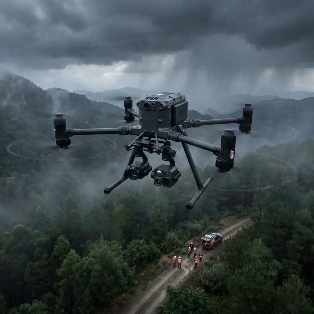
If your Matrice 400 mission relies on O3 transmission, range on paper means less than antenna discipline in the field. A mountain site can turn a strong system into a weak one if the ground setup is careless. The core rule is simple: keep the broad face of the controller antennas oriented toward the aircraft’s expected flight path, not the antenna tips pointed at it. Pilots still get this wrong in steep terrain because they instinctively “aim” the antennas like spotlights. That reduces performance.
A better approach is to position yourself where the aircraft spends most of the mission with the fewest ridgeline interruptions, then adjust antenna orientation to maintain the strongest lateral presentation to the aircraft during climb-out and return. On mountain jobs, that often means setting up slightly offset from the obvious launch point rather than directly below the first ascent leg.
A practical pattern:
- Stand where you can preserve the cleanest line toward the first major turn point.
- Raise the controller and your own body position if scrub, vehicles, or slope shoulders interfere.
- Keep antennas broadside to the aircraft’s route, especially during the first climb and final descent.
- Reassess your position if the route drops behind a ridge, even briefly.
That last point is the one crews underestimate. A short terrain mask can create enough interruption to force unnecessary hesitation, route correction, or return logic. In a pure inspection flight, that is frustrating. In a delivery mission over mountain power lines, it can compromise timing, battery margin, and placement accuracy.
Why obstacle handling deserves more thought in corridor work
One reference detail from the source material stands out even though it comes from a different drone application: a drone can carry a capture net in an onboard compartment and release it after identifying a target, using the net to entangle another aircraft and bring it down to the ground.
For a civilian power line delivery team, the lesson is not about interception. It is about the operational reality of entanglement.
Mountain power corridors are full of snag hazards that function a lot like an unintended capture net: guy wires, branch tips, old line remnants, construction materials, and uneven structures near tower work zones. Once a drone becomes entangled, the result is often the same in mechanical terms as the source describes for a net capture system: the aircraft loses freedom of movement, gets dragged out of stable flight, and ends up descending to the ground under distress.
That detail has real planning value. It tells you not to evaluate the Matrice 400 only by nominal route clearance. You need to examine where an entanglement could happen during ascent, payload release, and return.
A disciplined pre-mission check should include:
- Approach and departure vectors around every temporary work area
- Suspended materials that may not appear clearly in a standard visual scan
- Vegetation overhang on the leeward side of towers
- Any rope, guide line, or loose installation material that could wrap rotors or landing gear
This is also where thermal signature analysis can quietly help. Thermal imagery is usually discussed for fault detection, but in cold mountain mornings it can also improve visual separation between infrastructure, terrain, and active work zones. It will not reveal every thin hazard, but it can make the operating environment easier to interpret when the visual background is cluttered.
Build the route with mapping discipline, not guesswork
Mountain power line delivery benefits from photogrammetry more than many teams expect. Not because every mission needs a full modeling exercise, but because terrain understanding saves time and battery cycles.
If you are running repeated deliveries into the same corridor, generate a terrain-aware model first. Use GCPs where practical to improve spatial confidence in your mapping output, especially if the route includes tight landing or drop zones where a few meters of error actually matter. A rough map may be enough for marketing visuals. It is not enough when you are repeatedly sending an aircraft through a narrow mountain approach with obstacles on both sides.
A sound workflow looks like this:
- Conduct a preliminary mapping mission with conservative altitude and overlap settings.
- Use GCP-supported processing if the landing area, tower base, or delivery point needs high positional confidence.
- Identify radio shadow areas and potential emergency loiter zones.
- Build waypoint logic that avoids terrain traps rather than merely shortening the route.
This is one of the biggest mindset shifts for new mountain operators. The shortest line between two points is often the least forgiving path for a loaded aircraft.
Battery strategy matters more uphill than operators admit
Hot-swap batteries are not just a convenience feature in this kind of work. They change field efficiency and mission continuity.
In mountain power line delivery, crews often lose more productivity to turnaround friction than to actual flight time. If the Matrice 400 supports hot-swap battery workflows, use that advantage systematically. Keep aircraft downtime short, maintain sortie rhythm, and avoid the rush that leads to skipped checks.
What operators should watch is not simply battery percentage, but the compound effect of altitude gain, wind exposure, and reserve demands during return. A route that looks comfortable on descent may be tight on the outbound climb with payload.
A useful practice is to separate your battery planning into three thresholds:
- Launch threshold: minimum condition for starting the route with payload
- Decision threshold: the point beyond which you do not continue deeper into the corridor
- Recovery threshold: protected reserve for unexpected headwind, repositioning, or alternate landing
That framework sounds basic, yet it is where many mountain jobs fail. Teams often evaluate batteries as if the aircraft will get a symmetrical return. In real terrain, the return can be less efficient due to crosswind shifts or the need to regain cleaner transmission geometry.
Security and reliability are part of utility operations
Utility and contractor workflows increasingly involve shared data, remote review, and asset documentation. That makes secure transmission and data handling more than an IT issue.
If your Matrice 400 environment uses AES-256 for data security, that matters operationally because mountain infrastructure work often crosses organizational boundaries. EPC teams, grid operators, survey providers, and maintenance contractors may all touch the mission outputs. Strong encryption supports chain-of-custody confidence for inspection imagery, route logs, and site documentation tied to critical infrastructure.
Security also intersects with training. If crews understand how data is handled from aircraft to controller to storage, they make better decisions about device usage, network transfer, and field recordkeeping. In a mountain operation, where teams are often mobile and working from improvised field positions, disciplined handling of data and communications prevents avoidable exposure.
Delivery operations should borrow habits from inspection teams
The best mountain delivery crews tend to act like inspection specialists. They document, compare, verify, and refine after each flight.
That means the Matrice 400 should not be treated as a one-direction transport tool. It should be part of a closed loop:
- Deliver the item
- Record environmental and route performance
- Review signal behavior along each segment
- Adjust antenna positioning and waypoint geometry for the next sortie
This kind of feedback loop is where performance gains accumulate. One tower approach may consistently degrade link quality because the crew sets up too low on the slope. Another route may create unnecessary exposure because the aircraft hugs a ridgeline that looks efficient but amplifies crosswinds. Small corrections compound quickly over a project.
If your team is still building that process, it helps to compare logs and flight notes with someone who has worked similar terrain. A practical way to discuss setup questions, route logic, or antenna placement with a specialist is through this direct project chat: https://wa.me/85255379740
A simple antenna positioning method for maximum range
The phrase “maximum range” gets thrown around too casually. In mountains, what you really want is maximum usable range with stable control and predictable video.
Here is a field method that works better than chasing headline distance figures:
First, identify the segment where terrain most threatens line of sight. That is the segment to optimize for, not the easiest open section near launch.
Second, position the pilot or ground station where the aircraft will remain visible or least obstructed through that critical segment. Sometimes moving 20 to 30 meters to a shoulder with a better angle has more value than any setting change.
Third, orient antennas so their faces, not tips, align with the aircraft’s path. As the aircraft changes elevation, avoid dramatic overcorrection. Smooth orientation changes preserve consistency.
Fourth, if the route bends behind terrain, consider whether a different launch point or staged operation would reduce total signal risk. Some mountain missions should not be flown as a single elegant route. They should be broken into safer segments.
This advice sounds almost too simple, but it addresses a core truth: mountain transmission problems are often geometry problems first.
Where the Matrice 400 fits best
The Matrice 400 makes sense in mountain power line delivery when the job requires more than lift. The platform needs to support a disciplined operation that blends transport, inspection awareness, mapping support, and secure data practices.
The source material’s description of a drone carrying a net in a compartment and releasing it to capture another aircraft is useful here in an indirect way. It highlights how quickly a drone’s fate changes once something external takes control of its movement. For mountain utility work, the commercial takeaway is clear: design every route and every work zone to avoid accidental entanglement, because once the aircraft is snagged, recovery options collapse fast.
Pair that with another concrete operational detail from the brief: use O3 transmission intelligently, especially through antenna positioning, because link quality in mountainous corridors is not a background concern. It is a primary mission variable. Add hot-swap battery discipline, thermal support where visibility is complex, photogrammetry with GCP-backed mapping for repeat routes, and a secure handling approach with AES-256, and you end up with a workflow that is built for the realities of the job rather than the brochure.
That is the standard worth aiming for. Not just getting the payload uphill, but doing it with repeatability, margin, and better decisions on every subsequent flight.
Ready for your own Matrice 400? Contact our team for expert consultation.