Delivering Solar Farms in Mountain Terrain With the Matrice
Delivering Solar Farms in Mountain Terrain With the Matrice 400: The Flight Profile That Actually Works
META: Expert guide to using the Matrice 400 for mountain solar farm delivery missions, with practical advice on flight altitude, thermal workflows, photogrammetry, BVLOS planning, and battery strategy.
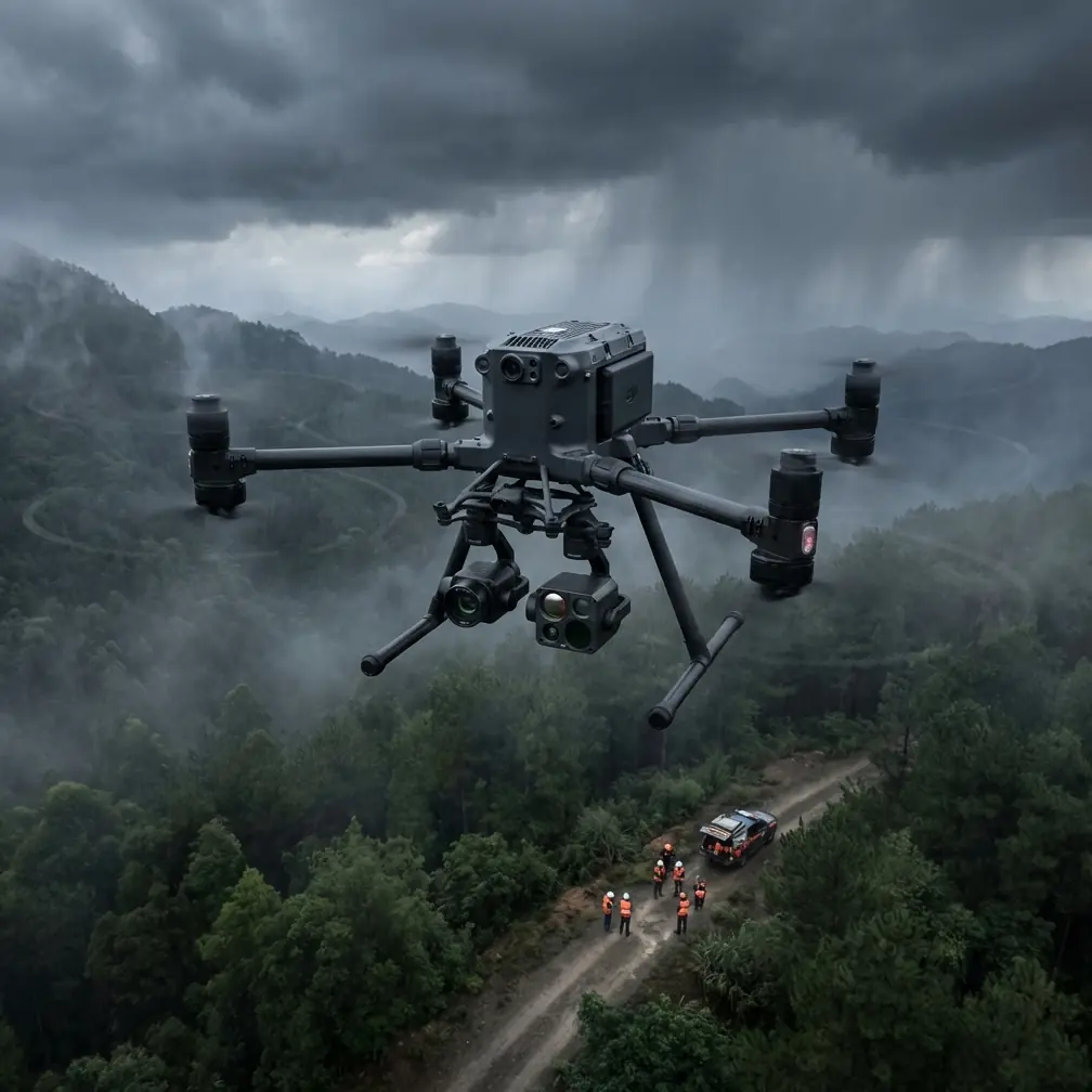
Mountain solar projects punish weak logistics. Roads are narrow or unfinished, weather turns quickly, and the final approach to a work zone often involves elevation changes that make even short distances operationally messy. If you are tasked with supporting a solar farm build in this kind of terrain, the aircraft matters less than the workflow built around it. That is where the Matrice 400 becomes interesting.
Not because it solves everything on its own. It does not. But because its architecture fits the real bottlenecks that show up on mountain solar sites: long transit legs between staging areas and ridge-mounted arrays, communications reliability when terrain blocks line of sight, sensor flexibility for both construction intelligence and asset verification, and the simple need to keep flying without losing time to cold battery swaps and unnecessary repositioning.
For this scenario, the common mistake is to think of the mission as a single job. It is really three jobs that overlap: site delivery support, survey-grade mapping, and thermal inspection readiness. The Matrice 400 is most useful when you treat it as the center of that combined operation.
The mountain problem is not distance. It is vertical complexity.
On flat ground, route planning tends to focus on horizontal coverage. In mountain solar developments, vertical geometry becomes the hidden cost driver. Ridges create signal shadows. Sloped arrays distort image overlap if altitude is referenced poorly. Battery performance becomes less predictable as temperature and wind shift between valley launch points and higher elevation work fronts.
That matters whether the aircraft is moving urgent components, scouting access corridors, or documenting construction progress. A mission that looks efficient on a top-down map can start failing the moment the aircraft crosses a ridge shoulder and transmission quality drops.
This is where O3 transmission becomes operationally significant. In mountain environments, stable high-quality video and command links are not just convenient for the pilot; they are what allow the team to continue precise routing when the aircraft moves in and out of complex terrain profiles. A robust transmission system gives the crew more confidence to operate from safer launch positions rather than chasing the aircraft with vehicles for every segment. On solar jobs where each reposition burns labor and daylight, that adds up quickly.
If your program includes BVLOS planning, this becomes even more consequential. Mountain solar sites are exactly the kind of environment where BVLOS can deliver real value, but only if the communications design, route segmentation, and emergency procedures are engineered with terrain in mind. The Matrice 400’s suitability here is less about marketing labels and more about pairing dependable link performance with disciplined corridor planning.
The best altitude for mountain solar work is usually lower than teams expect
Let’s address the practical question directly: what is the optimal flight altitude for delivering and supporting solar farms in the mountains with the Matrice 400?
For mapping and construction-progress capture over sloped solar arrays, the sweet spot is often around 60 to 90 meters above ground level, not a generic one-size-fits-all height. That range usually gives you the best balance between image detail, overlap control, and terrain-following safety. On mountain sites, flying much higher can flatten useful visual detail and reduce your ability to spot installation inconsistencies, drainage issues, cable routing problems, and frame alignment errors near breaks in slope.
For thermal missions, especially when you are checking strings, combiner areas, or suspected hotspots after partial energization, the optimal altitude often tightens further to 40 to 70 meters AGL, depending on sensor resolution, panel spacing, ambient conditions, and the angle of the slope. Too high, and thermal anomalies lose definition. Too low, and your coverage efficiency collapses while terrain-induced turbulence starts to interfere with smooth passes.
The key phrase here is above ground level. In mountain solar projects, crews that plan using a constant altitude above takeoff point often collect inconsistent data because the distance to the surface changes dramatically across the site. The result is uneven ground sample distance, poor photogrammetry outcomes, and thermal datasets that are harder to compare from one flight line to the next. Terrain-aware mission planning is not optional.
If I were building a standard operating profile for a Matrice 400 on a ridge-line solar project, I would start with these baseline rules:
- Use 70 meters AGL as a default starting altitude for visible-light photogrammetry.
- Drop toward 50 to 60 meters AGL when thermal signature detail matters more than raw area coverage.
- Increase altitude only when obstacle clearance, wind shear, or array geometry forces it.
- Plan separate profiles for delivery support and inspection rather than trying to combine everything into one compromised flight.
That altitude discipline is what turns a capable aircraft into a productive one.
Why hot-swap battery workflow matters more in the cold
Mountain sites expose one of the most underestimated inefficiencies in drone operations: dead time between sorties. Crews often focus on flight endurance, which is reasonable, but the larger operational drag is frequently what happens on the ground. You land, data needs to be checked, temperatures are lower than expected, batteries need managing, and the field team is waiting for the next update before moving material or adjusting labor deployment.
This is where hot-swap batteries have direct value. On a mountain solar build, the ability to cycle power systems quickly without turning every landing into a prolonged reset helps preserve sortie rhythm. That matters for time-sensitive tasks such as validating module placement on a newly completed block before installers move onward, or rechecking a lift path after unexpected weather changes.
Cold conditions complicate battery behavior, and mountain winds often do the rest. A hot-swap capable workflow does not eliminate those constraints, but it shortens the gap between useful flights. Over a full workday, that may be the difference between finishing a valley sector and leaving one ridge unverified until the next weather window.
Thermal work is only useful when it is tied to action
A lot of teams say they are “doing thermal,” but what they really mean is collecting warm-looking imagery. That is not the same thing as actionable inspection.
On a mountain solar project, thermal signature analysis with the Matrice 400 should answer specific field questions. Is there evidence of uneven heating across recently installed strings? Are certain sections showing abnormal patterns linked to mounting stress, connector faults, or debris accumulation after wind events? Is there a recurring thermal issue near terrain transitions where runoff and soil movement affect supporting infrastructure?
The thermal camera is not there to produce attractive color palettes. It is there to compress decision time.
That is why altitude, time of day, and repeatability matter so much. A thermal pass flown at 55 meters AGL on a clear, repeatable route is far more useful than a broad, high-altitude sweep that misses subtle anomalies. Consistency allows the project team to compare sectors, track whether an issue is persistent, and decide whether a technician needs to climb to a row immediately or whether the problem can wait for a scheduled service window.
For mountain solar delivery operations, this also ties back to logistics. If the aircraft spots a thermal irregularity while crews are already mobilized in a remote section, the site can redirect resources before the access route has to be used again. On steep terrain, avoiding one extra truck movement is not trivial.
Photogrammetry succeeds or fails on control discipline
If the mission includes construction verification, drainage planning, stockpile tracking, or as-built documentation, the Matrice 400 needs to be used as a photogrammetry platform with survey habits, not just piloting habits.
That starts with GCP strategy. Ground control points are especially valuable on mountain projects because slope and elevation variance can amplify small geospatial errors. If your GCP layout is weak, your model may still look visually convincing while carrying enough positional drift to create headaches in grading validation, access road checks, or tracker alignment analysis.
A good rule for mountain solar sites is to place GCPs across changes in elevation, not only around the perimeter. You want control on valley sections, mid-slope transitions, and upper benches. That gives your photogrammetry workflow stronger geometric stability and improves confidence in the final map products used by engineering and site management teams.
Operationally, that means the Matrice 400 is not just helping with “surveying.” It is supporting construction decisions that affect schedule, rework, and safety. A properly controlled model can reveal where drainage channels are undercutting access paths, where material staging is crowding safe movement corridors, and where array rows are diverging from plan before those errors multiply.
Security is not a side note on critical infrastructure jobs
Solar farms in mountain regions are often remote, but they are still critical infrastructure projects. Data handling matters. Site imagery can reveal electrical layouts, access roads, equipment positions, and security blind spots. If the program involves progress reporting, EPC coordination, or third-party review, your data pipeline should be treated accordingly.
AES-256 matters here because it supports a stronger security posture around mission data and communications. That is not a theoretical checkbox. For operators working on utility-scale energy sites, secure handling of imagery, telemetry, and operational files is part of being taken seriously by project owners and compliance teams. A mature Matrice 400 workflow is one where cybersecurity is built into the operating model rather than added after the client asks uncomfortable questions.
A practical mountain solar workflow for the Matrice 400
If I were advising a team mobilizing to a mountain solar project tomorrow, I would structure the Matrice 400 operation like this:
First, establish one launch point for each terrain sector instead of trying to command the entire site from a single valley base. Even with strong transmission performance, mountain topography rewards segmented control.
Second, run a terrain-referenced mapping mission at roughly 70 meters AGL to create a current visual and elevation-aware baseline. Use proper overlap and a GCP layout that spans height changes, not just horizontal extent.
Third, identify work fronts where thermal confirmation will save the most field time. Then fly those sectors separately at 50 to 60 meters AGL under stable environmental conditions.
Fourth, reserve battery rotation and hot-swap discipline for the moments when the field team is waiting on drone-derived decisions. Do not waste your fastest turnaround cycles on low-priority collection.
Fifth, build your communications and contingency plan around likely signal degradation zones before the first flight. O3 transmission is a strength, but terrain still wins if the mission is designed carelessly.
And sixth, if you are preparing for BVLOS expansion, document every mission segment now. Mountain solar sites reward the teams that build procedural evidence early.
If your crew is refining that kind of workflow and wants to compare notes on route design or payload strategy, you can message the operations desk here.
The Matrice 400 fits this mission when the operator respects the terrain
The Matrice 400 is a strong fit for mountain solar farm delivery and support work because it can unify logistics support, inspection, and mapping into one field-ready platform. But the aircraft is only half the story.
The real advantage comes from using the right altitude for the right job, maintaining thermal discipline, anchoring photogrammetry with solid GCP placement, leveraging O3 transmission without overestimating it, protecting sensitive project data with AES-256, and keeping sortie tempo high through a well-managed hot-swap battery process.
On flat sites, sloppy workflow can hide for a while. In the mountains, it gets exposed quickly.
That is why the best Matrice 400 teams do not ask only how far or how long the aircraft can fly. They ask a sharper question: at what altitude, with what control structure, and for which decision on the ground?
For mountain solar operations, that question is where productivity starts.
Ready for your own Matrice 400? Contact our team for expert consultation.