Matrice 400 for Windy Venue Deliveries: A Field Report
Matrice 400 for Windy Venue Deliveries: A Field Report on Sensors, Mapping, and the Small Steps That Prevent Big Errors
META: Expert field report on using Matrice 400 for windy venue delivery operations, with LiDAR, GPS error sources, photogrammetry outputs, and practical pre-flight safety workflow.
By Dr. Lisa Wang, Specialist
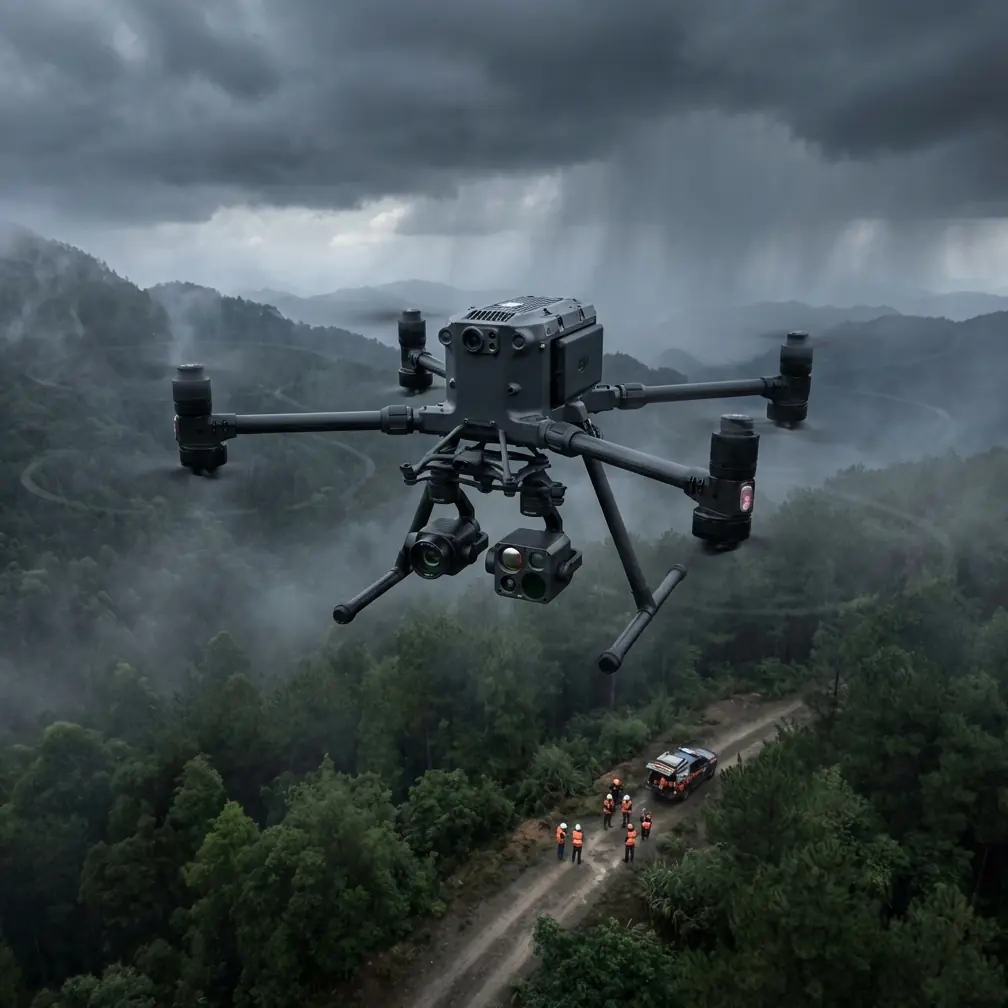
Venue delivery looks simple from the outside. A drone lifts off, crosses a crowded campus, stadium, resort, or exhibition ground, then drops a payload at a designated point. In real operations, the difficult part is not the straight-line flight. It is maintaining reliable positioning, clean situational awareness, and predictable landing behavior when wind, reflective surfaces, temporary structures, and foot traffic all compete for attention.
That is where the Matrice 400 conversation gets serious.
For this type of mission, the aircraft itself is only half the story. The rest comes from the sensor stack and the workflow behind it: how you collect terrain information, how you verify positional quality, and how you turn raw data into an operational map that a delivery team can trust. The reference material behind this article is old-school in the best sense. It focuses on fundamentals: how LiDAR actually works as an integrated sensing system, what GPS errors do to your position estimate, and how photogrammetry software converts thousands of images into products that matter in the field.
Those basics still decide whether a windy venue mission feels routine or fragile.
The pre-flight cleaning step most crews rush past
Before discussing mapping outputs or flight envelopes, start with a detail many teams underestimate: clean the sensing surfaces before powering into the mission sequence.
On a Matrice 400 prepared for venue delivery, that means checking and gently cleaning exposed vision sensors, LiDAR windows if installed, thermal optics if the payload stack includes thermal signature assessment, and any downward or forward-facing optical elements that support obstacle awareness or landing precision. In a windy venue, airborne dust, pollen, food grease haze near concession zones, salt residue near waterfront event sites, or plain fingerprint smearing can degrade what the aircraft “sees” long before the pilot notices anything unusual on screen.
This sounds minor. It is not. Safety features only work at their designed level when the sensing path is clear. If your mission depends on automated perception, route verification, or precise approach behavior near temporary fencing and truss structures, a dirty sensor face can quietly erode the margin you thought you had.
That single pre-flight cleaning step is one of the cheapest ways to protect high-value safety features.
Why LiDAR matters more than brochure-level talking points suggest
One of the strongest reference facts is also one of the most misunderstood: LiDAR is not just a laser. It is an integrated device that combines laser measurement, GPS, and IMU. That matters because venue delivery in wind is fundamentally a spatial problem. You are not simply avoiding obstacles; you are constantly estimating where the aircraft is in 3D space, how the environment is shaped around it, and how much confidence you can place in that model.
The source material describes LiDAR output as a discrete representation of a digital surface model, carrying both 3D spatial information and laser intensity information. Operationally, that gives a Matrice 400 team something much more useful than a flat site sketch. You get a measurable surface that includes roofs, tents, staging, vegetation, barriers, and other above-ground features that often define delivery risk at event venues.
That distinction between surface model and ground model is not academic. If you plan a route using only a simplified map, a temporary canopy line or elevated rigging element can become a surprise. With LiDAR-derived data, the team can classify raw surface points and remove buildings, artificial objects, or vegetation to derive a digital elevation model. The result is a much clearer separation between actual terrain and everything built or placed on top of it. For venue operations, that helps with three things:
Approach path design
You can distinguish true ground slope from temporary structures when defining safe delivery approaches.Landing zone validation
A flat-looking area in a standard image may actually be cluttered by low-profile event infrastructure. Surface data exposes that.Wind interaction awareness
Structures shape gust behavior. A 3D site model helps crews anticipate where wind shear or rotor turbulence may be amplified.
The reference manual also lists LiDAR performance metrics that experienced operators should care about: weight, range, power, horizontal and vertical field of view, points per second, scan frequency, accuracy, and channel count. Those are not spec-sheet filler. They define whether the sensor is suitable for a moving multirotor platform.
The example cited in the source, a Velodyne VLP-16, is especially revealing. It weighs 0.83 kg, scans to 100 m, operates at 8 W, covers 360° horizontally and ±15° vertically, captures 300,000 points per second, runs at 5–20 Hz, and offers ±3 cm identification accuracy with 16 channels. Even though a Matrice 400 deployment may use a different payload, these numbers illustrate the threshold at which airborne LiDAR became practical for multirotors. Small enough to fly. Fast enough to be useful. Accurate enough to influence route planning rather than just produce attractive visualizations after the fact.
For windy delivery venues, that is the difference between “we have site awareness” and “we have a model we can actually fly against.”
GPS confidence is never automatic, especially around venues
The second reference thread is about GPS pseudorange and error sources, and it deserves more attention than most delivery operators give it. The source notes that pseudorange positioning is affected by the ionosphere, troposphere, and clock error. It also highlights a practical detail that speaks directly to field reliability: receiver clock bias exists because the GPS receiver typically uses a high-precision quartz clock, not the GPS system’s own time standard.
Why should a Matrice 400 pilot working a windy venue care?
Because event environments are full of circumstances that reward false confidence. Open plazas can make positioning feel easy, but nearby grandstands, glass facades, steel roofing, temporary towers, and broadcast infrastructure can complicate the quality of your navigation solution. The reference material points out that the basic GPS positioning problem includes four unknowns. That reminder is useful. A map pin on the controller is not a simple truth. It is a computed estimate produced through corrections and assumptions.
The cited pseudorange precision values make this plain. C/A code pseudorange is around 20 meters in accuracy, while P code pseudorange is around 2 meters. You do not need to become a satellite-navigation theorist to see the implication: raw positional information varies enormously in quality, and professional workflows exist because “GPS says I’m here” is often not enough for precise aerial work.
For venue delivery, the operational significance is direct:
- If you are using photogrammetry outputs to define delivery corridors, poor position quality in source imagery can propagate into route errors.
- If your aircraft is approaching a designated drop zone bordered by people, railings, decorative structures, or rooftop equipment, meter-level slop can become unacceptable.
- If the mission concept includes BVLOS-style oversight on large properties, the crew needs strong confidence in both aircraft position and site model alignment.
This is also where disciplined use of GCP workflows remains relevant. Even when a modern platform offers strong onboard navigation and high-grade transmission links, ground truth still matters when you are building maps for repeatable operations.
Photogrammetry turns a venue from a place into a dataset
The software references in the source material are easy to dismiss as dated brand mentions, but the underlying workflow is highly relevant to the Matrice 400. The key idea is that thousands of aerial images can be turned, with minimal manual intervention, into accurate 2D maps and 3D models. That changes how venue delivery teams prepare for missions.
Instead of scouting a site as a pilot would, you can structure it as a data engineer would.
The reference mentions outputs including DEM, DSM, DOM, and oblique 3D models. Each has a different role:
- DEM helps you understand bare-earth elevation.
- DSM preserves above-ground features such as structures and vegetation.
- DOM gives georeferenced orthographic imagery for planning and communication.
- Oblique 3D models help teams inspect complex venue geometry from realistic angles.
A Matrice 400 team serving windy delivery venues can use these outputs in sequence. First, build a DOM for route briefing and stakeholder alignment. Then compare DSM and DEM to identify obstacles and elevation transitions. If the drop zone sits near a grandstand, hotel terrace, exhibition canopy, or landscaped berm, that differential matters. Finally, use an oblique model to confirm approach visibility and the practical spacing around the handoff area.
The source also references automated aerial triangulation and precision reporting. That matters because speed alone is not the point. The value lies in being able to assess result quality quantitatively. In venue operations, everyone likes a fast map. What the flight department actually needs is a trustworthy map.
This is where photogrammetry and LiDAR complement each other rather than compete. Photogrammetry is efficient and rich in visual detail. LiDAR gives stronger structural understanding and point-based geometry, with laser intensity adding another layer of interpretation. For some Matrice 400 missions, especially when site complexity or repetitive operations justify the effort, combining both methods produces a far more resilient planning environment.
Wind changes how mapping products should be used
Windy venue delivery is not just a flight-control issue. It changes how you should interpret your planning data.
A 2D orthomosaic can make a site look orderly and open. Wind exposes the truth. Flags whip into corridors. Temporary scrim walls flex. Trees lean into paths that seemed generous on a calm survey day. Queue barriers migrate. Rooftop turbulence intensifies near parapets and HVAC structures. A Matrice 400 operating in this environment needs more than a pretty base layer.
This is why a DSM or LiDAR-derived point cloud is so valuable. It gives height context. It helps the crew think volumetrically. And when paired with a thermal signature payload during pre-mission site assessment, it can also reveal heat-heavy equipment zones, generator clusters, or pavement hotspots that signal congested operational areas rather than safe landing spaces.
Not every venue needs that level of rigor. But repeated deliveries into the same property often do. Once you move from one-off demonstration flights to dependable service, the data standard should rise with the mission frequency.
Transmission security and continuity still belong in the planning conversation
The context around Matrice 400 also points toward O3 transmission, AES-256, and hot-swap batteries. Those features matter less as isolated product bullets than as links in the operational chain.
A windy venue can create intermittent visual complexity and route deviations. Strong transmission architecture supports cleaner command and monitoring continuity over large properties, especially when the crew must maintain stable oversight across structures or temporary installations. AES-256 matters when venue clients are sensitive about site imagery, infrastructure layouts, or event logistics being transmitted and stored. And hot-swap batteries are not just about uptime. They support repeatability in survey and rehearsal cycles, where crews may need to remap, validate a route, then execute the actual delivery window without introducing unnecessary turnaround delays.
Those are planning enablers, not luxury options.
A practical workflow for Matrice 400 venue delivery teams
For teams building a real program, not a demo reel, the workflow should look something like this:
Start with a fresh sensor cleaning check. Then survey the venue using photogrammetry, LiDAR, or both depending on complexity. Generate a DOM for briefing, a DSM and DEM for vertical understanding, and an oblique model if approach geometry is tight. Validate map quality with control logic appropriate to the job, especially where GCP-backed accuracy matters. Compare likely routes against wind exposure points created by buildings, staging, and vegetation. Rehearse approach and exit paths using the most current model, not last month’s. Then keep the sensing surfaces clean enough that the onboard safety stack can do the work you are asking it to do.
That rhythm is what turns a capable aircraft into a dependable venue tool.
If you are sorting through payload combinations or mapping workflow decisions for this kind of deployment, you can message our flight planning desk on WhatsApp and speak to someone who understands the operational side, not just the catalog side.
The real lesson from the reference material
The most useful takeaway from the source documents is not tied to any single brand of software or sensor. It is this: professional drone work becomes reliable when measurement, correction, and interpretation are treated as one system.
LiDAR is valuable because it integrates laser, GPS, and IMU into a coherent spatial instrument. GPS matters because its errors are real and structured, not random trivia. Photogrammetry matters because automated processing can turn large image sets into map products that support repeatable decisions. Put together, these ideas form the backbone of a strong Matrice 400 workflow for windy venue delivery.
And that is the standard worth aiming for. Not a clean marketing narrative. A clean operational one.
Ready for your own Matrice 400? Contact our team for expert consultation.