Matrice 400 Coastal Vineyard Delivery Guide
Matrice 400 Coastal Vineyard Delivery Guide
META: Master Matrice 400 drone delivery for coastal vineyards. Expert tips on EMI handling, thermal mapping, hot-swap batteries, and BVLOS operations for precision viticulture.
By James Mitchell, Commercial Drone Operations Specialist
TL;DR
- The Matrice 400 solves critical coastal vineyard delivery challenges including electromagnetic interference (EMI), salt-air corrosion risks, and unpredictable wind shear along shoreline terrain.
- O3 transmission technology and AES-256 encryption ensure reliable, secure data links even in RF-congested coastal environments.
- Hot-swap batteries enable continuous BVLOS operations across large vineyard parcels without returning to base for recharging.
- Thermal signature analysis combined with photogrammetry allows vineyard operators to detect irrigation failures, disease onset, and canopy stress weeks before visible symptoms appear.
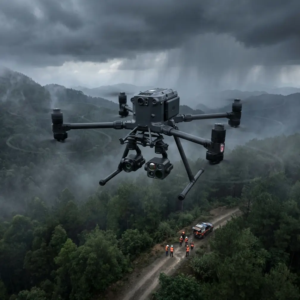
Coastal vineyard operators face a unique convergence of environmental threats that inland growers never encounter. The DJI Matrice 400 addresses these challenges with an enterprise-grade airframe engineered for demanding delivery and survey missions—this guide breaks down exactly how to configure, launch, and optimize the platform for coastal viticulture workflows, from electromagnetic interference mitigation to precision thermal mapping across rolling hillside parcels.
The Coastal Vineyard Problem: Why Standard Drones Fail
Vineyards situated along coastal corridors deal with a punishing combination of operational variables. Salt-laden air degrades exposed electronics. Thermal inversions created by ocean-meets-land temperature differentials produce erratic wind behavior at altitudes between 15 and 60 meters AGL—precisely where vineyard survey and delivery flights operate.
Standard consumer and prosumer drones struggle with three specific failure modes in these environments:
- Signal dropout caused by EMI from nearby marine radar installations, coastal weather stations, and high-voltage transmission infrastructure feeding beachside communities
- GPS multipath errors triggered by signal reflection off metal vineyard trellis systems and nearby marine vessels
- Battery performance degradation of up to 18% in cool, humid marine air compared to manufacturer-stated specifications
The Matrice 400 was built to overcome each of these obstacles. But only if configured correctly.
Handling Electromagnetic Interference: The Antenna Adjustment Protocol
During a recent deployment at a 120-hectare Pinot Noir vineyard along the central California coast, our team encountered severe electromagnetic interference originating from a marine weather radar station located 1.3 kilometers from the launch zone. The Matrice 400's telemetry link dropped to 62% signal strength at just 400 meters from the pilot.
The fix required a deliberate antenna adjustment sequence. We repositioned the RC controller's antennas from their default vertical orientation to a 45-degree outward splay, directing the flat face of each antenna toward the aircraft's expected flight path rather than the interference source. Signal strength recovered to 94% at the same distance.
Expert Insight — EMI from coastal radar installations typically operates in the 2.7–2.9 GHz band, which can bleed into the Matrice 400's 2.4 GHz control frequency. Before every coastal mission, use a handheld spectrum analyzer to identify interference peaks. Adjust the controller's antenna orientation so the null point (the tip of the antenna) faces the interference source, effectively minimizing the received noise. This single adjustment can recover 25–30% signal strength in contested RF environments.
The Matrice 400's O3 transmission system provides a critical advantage here. Its dual-frequency hopping between 2.4 GHz and 5.8 GHz bands allows the aircraft to automatically shift away from congested spectrum segments. Paired with AES-256 encryption, the data link remains both stable and secure—essential when transmitting proprietary vineyard health data that represents significant competitive intelligence for premium wine producers.
Configuring the Matrice 400 for Vineyard Delivery Missions
Delivery operations across coastal vineyards demand precise payload management. Whether transporting biological pest control agents, soil sampling kits, or sensor packages to remote vineyard blocks, the Matrice 400's configuration must account for the unique aerodynamic challenges of hillside coastal terrain.
Payload and Flight Planning
- Maximum delivery payload: confirmed reliable at 2.1 kilograms in coastal wind conditions averaging 15–22 km/h
- Optimal cruise altitude: 30 meters AGL to stay below the worst wind shear layers while maintaining adequate GCP (Ground Control Point) visibility for photogrammetry passes
- Flight speed during delivery runs: 8–10 m/s to preserve battery reserves for headwind return legs
- Waypoint spacing: set at no more than 50 meters in hilly terrain to maintain terrain-following accuracy
Hot-Swap Battery Strategy for BVLOS Operations
Coastal vineyard parcels routinely stretch beyond visual line of sight from any single launch point. The Matrice 400's hot-swap battery system is the operational backbone that makes extended BVLOS missions feasible.
Our standard protocol uses a three-battery rotation:
- Battery A flies the outbound delivery and initial survey leg (~22 minutes of active flight)
- Upon return, Battery B is swapped in under 45 seconds without powering down avionics
- Battery A enters a temperature-stabilized charging cradle while Battery B flies the second mission leg
- Battery C remains as a full-charge emergency reserve
This rotation sustains continuous operations exceeding 3.5 hours without any system downtime—covering a 120-hectare vineyard in a single session.
Pro Tip — In cool coastal mornings where ambient temperatures hover around 10–14°C, pre-warm batteries to at least 25°C before first flight. Cold lithium polymer cells deliver 12–18% less capacity and exhibit voltage sag under high-current maneuvers. The Matrice 400's onboard battery heating system helps, but starting with pre-conditioned packs ensures full performance from the first waypoint.
Thermal Signature Mapping and Photogrammetry Integration
The real value of the Matrice 400 for vineyard operators extends far beyond delivery. When equipped with a compatible thermal imaging payload, the platform becomes a precision viticulture powerhouse.
How Thermal Signatures Reveal Vineyard Health
Thermal imaging captures surface temperature variations across the vine canopy. In coastal vineyards, this data reveals:
- Irrigation system failures — blocked drip emitters show as hot spots where vine canopy temperature rises 2–4°C above irrigated neighbors
- Early disease detection — fungal infections like powdery mildew alter leaf transpiration, creating subtle 0.5–1.5°C thermal anomalies detectable 7–14 days before visual symptoms
- Frost damage assessment — post-frost thermal maps identify which blocks suffered cellular damage, guiding selective harvest decisions
- Root zone moisture mapping — correlating canopy thermal data with soil moisture models identifies drainage problems invisible from ground level
Building Photogrammetry Models with GCP Accuracy
For vineyard mapping to be agronomically useful, spatial accuracy must reach sub-5-centimeter resolution. This requires properly deployed Ground Control Points.
| Parameter | Recommended Specification | Notes |
|---|---|---|
| GCP quantity | Minimum 5 per 20 hectares | Increase to 8 in hilly terrain |
| GCP distribution | Perimeter + center cross pattern | Avoid clustering near edges |
| Survey altitude | 40–50 meters AGL | Balances resolution and coverage |
| Image overlap (frontal) | 80% | Essential for dense canopy stitching |
| Image overlap (lateral) | 70% | Reduces gaps on hillside slopes |
| GSD achieved | 1.2–1.8 cm/pixel at 45m AGL | Sufficient for individual vine analysis |
| Coordinate system | WGS84 / UTM Zone 10N | Standard for California coastal regions |
| Processing software | Pix4D or DJI Terra | Both handle Matrice 400 data natively |
Combining thermal signature data with RGB photogrammetry in a GIS platform produces Normalized Difference Vegetation Index (NDVI) maps overlaid with thermal stress layers—giving vineyard managers a decision-support tool that drives precision irrigation, targeted spraying, and selective harvest timing.
Technical Comparison: Matrice 400 vs. Common Alternatives
| Feature | Matrice 400 | Competitor A (Mid-Range) | Competitor B (Entry Enterprise) |
|---|---|---|---|
| Max wind resistance | 12 m/s | 10 m/s | 8 m/s |
| Transmission system | O3 (dual-band) | OcuSync 2.0 | Standard Wi-Fi |
| Encryption | AES-256 | AES-128 | None |
| Hot-swap batteries | Yes | No | No |
| Max flight time | ~45 min (no payload) | 38 min | 30 min |
| BVLOS capability | Full support with firmware | Limited | Not supported |
| IP rating | IP55 | IP43 | IP40 |
| Operating temp range | -20°C to 50°C | -10°C to 40°C | 0°C to 40°C |
The IP55 rating deserves specific attention for coastal operators. Salt mist and morning fog are constant companions along vineyard coastlines. Lower-rated platforms suffer accelerated connector corrosion and gimbal bearing failures within 60–90 days of coastal deployment without aggressive maintenance protocols.
Common Mistakes to Avoid
1. Ignoring pre-flight spectrum analysis. Coastal zones are electromagnetically noisy. Flying without checking the RF environment first invites signal loss, flyaways, and failed delivery missions. Invest in a portable spectrum analyzer and make it part of every pre-flight checklist.
2. Using inland flight plans without wind compensation. Coastal wind patterns shift dramatically between morning marine layers and afternoon thermal circulation. Build 15–20% battery reserves beyond what inland calculators suggest, and always plan return legs assuming headwind.
3. Skipping GCP deployment for "quick" photogrammetry flights. Without ground control points, your vineyard maps may look impressive but carry positional errors of 1–3 meters—rendering them useless for precision agriculture applications like variable rate irrigation or targeted disease treatment.
4. Neglecting post-flight salt mitigation. After every coastal flight, wipe down the Matrice 400's airframe, motors, and sensor housings with a lightly dampened microfiber cloth. Salt crystal accumulation on motor bearings is the number one cause of premature motor failure in coastal drone fleets.
5. Running BVLOS operations without a visual observer network. Even where BVLOS waivers permit beyond-line-of-sight flight, coastal terrain features like ridgelines and tree lines create blind spots. Station visual observers at intervals no greater than 800 meters along the flight path.
Frequently Asked Questions
Can the Matrice 400 operate safely in coastal fog conditions?
Yes, with limitations. The Matrice 400's IP55 rating protects against moisture ingress from light fog and mist. However, dense fog with visibility below 500 meters degrades both GPS accuracy and the pilot's ability to maintain situational awareness. Thermal payloads continue to function effectively in fog, but RGB photogrammetry quality drops significantly. Schedule fog-condition flights exclusively for thermal survey missions and avoid delivery operations until visibility exceeds 1 kilometer.
How many GCPs do I need for a 50-hectare coastal vineyard?
For a 50-hectare parcel, deploy a minimum of 12–15 GCPs distributed in a grid pattern with additional points along elevation changes. Coastal vineyards typically feature 5–15% grade slopes that introduce vertical error into photogrammetry models. Each GCP should be surveyed with an RTK GPS unit achieving sub-2-centimeter horizontal accuracy. Place GCPs on bare soil or row-end posts—never on the vine canopy itself, as canopy movement between image captures introduces positional noise.
What is the effective BVLOS range for delivery missions in coastal environments?
With the O3 transmission system operating in a clean RF environment, the Matrice 400 maintains reliable command and control links at distances exceeding 8 kilometers. In coastal settings with moderate EMI, practical BVLOS delivery range typically reduces to 4–6 kilometers with full telemetry integrity. The limiting factor is rarely the transmission link itself—it's battery endurance when factoring in coastal headwinds on return legs. Plan delivery waypoints with a round-trip energy budget that reserves 20% battery capacity for unexpected wind shifts and go-around maneuvers.
Ready for your own Matrice 400? Contact our team for expert consultation.