Matrice 400 for Remote Vineyard Delivery
Matrice 400 for Remote Vineyard Delivery: A Specialist Case Study on Flight Altitude, Control Stability, and Mission Reliability
META: A field-driven Matrice 400 case study for remote vineyard delivery, covering optimal flight altitude, BVLOS planning, O3 transmission, AES-256 security, hot-swap batteries, thermal workflows, and stability lessons drawn from aircraft design principles.
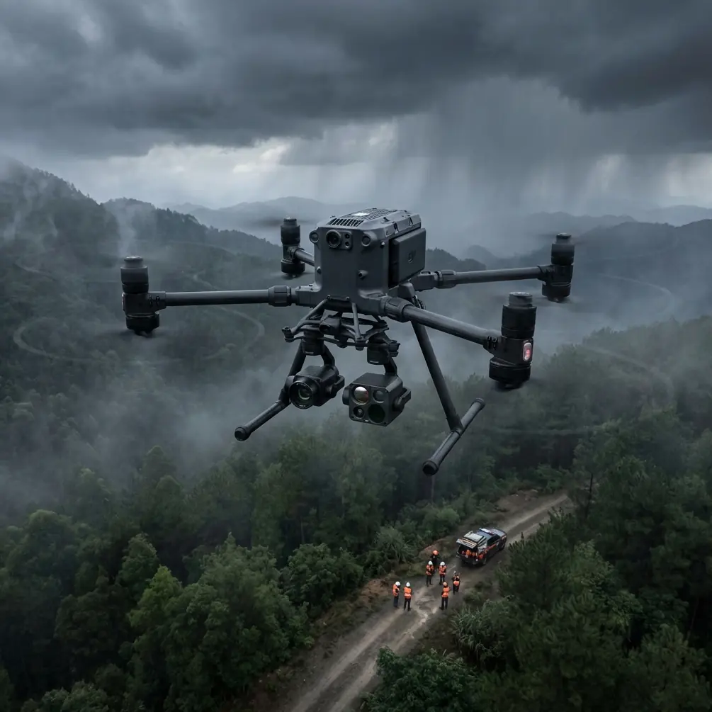
Remote vineyard logistics rarely fail for dramatic reasons. Most breakdowns are ordinary: a ridge blocks signal, a landing patch turns dusty and uneven, a payload arrives late because the aircraft had to fly around terrain instead of over it, or a battery swap takes longer than the crew expected. The Matrice 400 sits in an interesting place here. It is not just a camera platform and not merely a transport tool. In a remote vineyard operation, it becomes a system-of-systems problem: communications, stability, route design, landing discipline, environmental awareness, and repeatability all matter at once.
That is the lens I want to use for this case study.
I’m framing this as a vineyard delivery scenario because that is where the Matrice 400’s mission logic becomes clear. Imagine an estate with blocks spread across broken ground, access roads softened by irrigation runoff, and work teams moving between vine rows, pump stations, and hillside service points. The aircraft is tasked with delivering small but time-sensitive items: sensors, sampling kits, field tools, replacement parts, documents, or treatment-related materials. The goal is not novelty. The goal is to cut transit time without creating a fragile operation.
Why altitude matters more than most operators think
For remote vineyard delivery, the most practical altitude question is not “How high can the aircraft go?” It is “What altitude keeps the route stable, connected, and safe over changing terrain while preserving precise arrival control?”
In most vineyard missions of this type, the optimal working band is not extreme. A moderate cruise altitude often performs best because it balances three competing needs:
- clearance over trellises, trees, wires, and terrain folds
- line-of-sight quality for O3 transmission during extended routes
- manageable descent geometry into small receiving zones
In the field, I usually advise starting route design with a conservative altitude buffer above the tallest predictable obstacles, then adjusting upward only when signal continuity or topography demands it. In ridge-cut vineyard layouts, the wrong instinct is to fly too low for the whole mission. Low flight may look efficient on a map, but in reality it can increase signal masking, force repeated micro-climbs, and raise pilot workload during BVLOS planning.
This is where one of the reference materials, although drawn from conventional aircraft design, becomes surprisingly relevant. In the handbook extract from 起飞着陆系统设计 (takeoff and landing system design), Chapter 9 focuses on nose wheel steering and shimmy damping systems, with “工作原理” listed on page 410 and multiple aircraft examples including the MD-80, RF-101, and F-16A. That may sound far removed from drones, but the operational lesson is direct: directional control is never just about turning authority; it is about suppressing oscillation and maintaining predictable tracking when conditions try to destabilize motion.
For the Matrice 400, we do not have a nose wheel shimmy problem. We do have the drone equivalent: route deviations caused by gusts, corridor compression between vineyard obstacles, and unstable final approach paths into tight landing spots. The takeaway is that altitude should be selected partly for path damping. A slightly higher and cleaner cruise segment often produces a smoother track than a lower route that forces constant corrections around terrain contours.
In other words, your best vineyard altitude is the one that reduces cumulative instability, not simply the one that minimizes vertical distance.
A practical altitude model for remote vineyard delivery
For this scenario, I recommend dividing the mission into three altitude zones rather than using one fixed number from takeoff to landing.
1. Departure and clearance zone
This is the climb phase from the launch site to a safe transit corridor. The objective is obstacle separation and clean initial link quality. In a vineyard with poles, tree lines, and occasional utility crossings, this zone should be high enough to clear all known structures with margin, but not so high that the aircraft wastes energy in unnecessary climb.
2. Transit zone
This is where the Matrice 400’s O3 transmission and BVLOS planning do the heavy lifting. For remote estate routes, transit altitude should favor terrain smoothing. If the vineyard sits across undulating slopes, a modestly elevated cruise line often preserves better control confidence than a route that hugs the contours.
3. Delivery descent zone
This is where many operations become sloppy. Crews spend time planning the middle of the route and then improvise the last 30 seconds. Don’t. The descent into a vineyard receiving point should be standardized: approach vector, altitude gates, hover confirmation, downwash check, and landing or release procedure depending on mission design.
That same design discipline echoes another reference document, 生命保障和环控系统设计 (life support and environmental control system design). Its extract includes 座舱气密系统设计 with sections on air source, hose routing, and requirements for cabin airtightness, plus reliability testing on page 409. The military context is irrelevant for our purposes, so I ignore it. What matters is the engineering habit behind those sections: environmental systems are only dependable when airflow paths, sealing quality, and test protocols are treated as integrated design variables.
Applied to the Matrice 400 in vineyard work, the equivalent is this: payload protection, dust exposure during landing, battery compartment discipline, and thermal management during repeated sorties should not be treated as afterthoughts. If your receiving area is dry, sloped, or exposed to rotor wash, the mission needs environmental control logic. That may mean using elevated landing pads, revising descent rate, or avoiding low-hover loiter over loose soil that can contaminate payload surfaces and aircraft components.
The reference’s emphasis on reliability testing is especially relevant. If you plan to run repeated delivery cycles in agricultural terrain, test the same route profile multiple times under varying heat and wind windows. A one-off successful mission proves very little.
Where the Matrice 400 earns its place
The Matrice 400 becomes most valuable when the vineyard operation is spread out enough that every ground run costs labor minutes, but the site is still complex enough that basic point-to-point drone flying would be unreliable without serious planning.
Several platform features matter here.
O3 transmission is not just a brochure feature in a remote vineyard. It is the backbone of route confidence. Estates with ravines, terraces, and tree breaks create intermittent masking conditions. A robust transmission system widens the envelope for practical route placement and gives crews more flexibility when selecting a transit altitude that avoids terrain interference.
AES-256 matters as well, and not only for abstract cybersecurity reasons. Agricultural operations increasingly move sensitive data through the same airframes used for logistics: block maps, yield-linked sample locations, disease scouting records, irrigation anomalies, and treatment timing notes. If the delivery mission also carries survey outputs or thermal inspection files, encrypted transmission becomes operationally meaningful.
Hot-swap batteries are another real advantage in this use case. Vineyards do not like waiting. Field teams move. Conditions shift. If an aircraft can return, swap power rapidly, and relaunch without dragging the whole operation into reset mode, that changes sortie economics. It also supports a smarter mission pattern: shorter, repeatable flights with clear task boundaries instead of pushing single flights too far just because the crew wants to “get everything done in one run.”
That discipline becomes even more useful under BVLOS workflows, where route structure, battery reserve policy, and contingency points need to be defensible. A hot-swap-capable aircraft supports that kind of operational rigor.
Delivery aircraft, mapping aircraft, and thermal aircraft in one program
A lot of vineyard operators make the mistake of separating logistics flights from data flights too aggressively. In practice, the Matrice 400 can support a blended operational program.
A morning mission might begin with a delivery run to a remote crew. The same aircraft later flies photogrammetry over a problem block, tied to GCP control points for higher mapping consistency. In the late afternoon, it can support a thermal signature survey to identify irrigation irregularities, canopy stress patterns, or equipment overheating around pumps and infrastructure.
Why mention this in an article about delivery? Because mission altitude decisions should account for the whole operating day, not just one leg.
For example, a delivery route flown too low may save a minute but generate little useful terrain perspective for later mission planning. By contrast, a well-designed cruise corridor can help crews understand sightlines, interference zones, and thermal clutter across the estate. If you are already operating the Matrice 400 as a multi-role asset, every delivery sortie can feed better mapping and inspection decisions.
That is one reason I advise vineyard managers to document altitude findings block by block. Some slopes produce wind shear near ridge lips. Some service roads create dust plumes that complicate descent. Some receiving points sit close to reflective surfaces that affect onboard sensing or thermal interpretation. Over time, the aircraft stops being a mere courier and becomes part of the estate’s operational intelligence system.
The receiving site is half the mission
A remote vineyard delivery chain is only as good as its least controlled landing area.
This is where the aircraft-design references quietly help again. The section on steering and damping reminds us that ground interaction must be controlled, not improvised. The section on environmental design reminds us that dust, airflow, sealing, and reliability affect system life. Put together, they point to one simple truth: build disciplined receiving zones.
For the Matrice 400, that means:
- stable, marked touchdown or handoff area
- known obstacle perimeter
- clear final approach direction
- reduced loose dust and debris
- repeatable crew position during receipt
- pre-defined abort path if the site is occupied
This is not bureaucracy. It is what turns a drone route into a usable logistics lane.
If your vineyard has multiple remote work points, classify them. Some can support direct landing. Some are better handled by hover transfer. Some should be reassigned because their terrain geometry forces unstable approaches. A route that looks excellent in the air can still be poor in operation if the last few meters are inconsistent.
A field note on thermal signature and altitude
Since thermal signature is one of the scenario hints, let’s deal with a common misconception. Operators sometimes assume that a delivery mission flown at one stable altitude will also generate useful thermal context by default. Not necessarily.
Thermal readings in vineyards are highly sensitive to time of day, canopy density, irrigation timing, exposed soil, and slope orientation. If the Matrice 400 is being used in a mixed mission profile, the altitude that works best for delivery may not be ideal for thermal interpretation. Delivery altitude should prioritize route continuity and receiving precision. Thermal altitude should prioritize pixel utility and scene consistency.
Still, there is overlap. A delivery mission can help identify where thermal follow-up is worthwhile. If crews repeatedly request supplies in one block, or if a route passes over visibly stressed rows, a later thermal sortie can validate whether the issue is irrigation, disease pressure, or localized equipment failure.
What I would deploy first
If I were designing a Matrice 400 program for a remote vineyard estate today, I would begin with one narrow use case and expand from there:
- establish a fixed launch site
- choose one remote receiving point with clear terrain
- define a moderate transit altitude that preserves obstacle margin and signal quality
- validate O3 link stability across several times of day
- test hot-swap turnaround under realistic crew conditions
- add a second receiving point only after descent procedures are standardized
- layer in photogrammetry and GCP-backed mapping once logistics flights are stable
- add thermal sorties as a separate mission profile, not as an afterthought
This order matters. Too many teams try to use every capability at once. The result is a flashy demo and a weak operation.
If you are evaluating whether your vineyard topography is suitable for this kind of workflow, a practical way to discuss route design, altitude bands, and payload handling is to message a UAV specialist directly.
The real lesson from the reference materials
The two handbook excerpts are not drone manuals, and they do not need to be. They point to something more enduring than any single airframe specification.
From the landing-system volume, the section on steering and damping shows that control without stability is not enough. For the Matrice 400 in vineyard delivery, this translates into altitude choices and approach designs that reduce oscillation, not just direct the aircraft from A to B.
From the environmental-control volume, the sections on air source, hose routing, airtightness requirements, and reliability testing show that dependable operation comes from integration and verification. For the Matrice 400, that means landing-zone design, dust management, battery handling, encrypted data workflows, and repeat-route testing all belong inside the same mission architecture.
That is why the best altitude insight for remote vineyard delivery is not a single number. It is a method: fly high enough to smooth terrain and preserve the link, low enough to keep descent efficient and controlled, and consistently enough that every repeat mission becomes more reliable than the last.
Ready for your own Matrice 400? Contact our team for expert consultation.