Matrice 400 for Coastal Wildlife Delivery
Matrice 400 for Coastal Wildlife Delivery: A Technical Review from the Field
META: Expert technical review of the Matrice 400 for coastal wildlife delivery, covering pre-flight cleaning, thermal workflows, BVLOS planning, O3 transmission, AES-256 security, hot-swap batteries, and photogrammetry support.
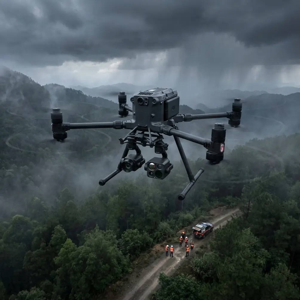
Coastal wildlife work punishes aircraft in ways inland operators often underestimate. Salt hangs in the air, moisture finds connectors, sand collects around seals, and mission profiles rarely stay simple. One sortie may begin as a supply drop to a rehabilitation point, pivot into a thermal scan for stranded animals, and end with site mapping for habitat change analysis. That is exactly the kind of mixed-duty environment where the Matrice 400 deserves a closer look.
I approach this aircraft less as a headline product and more as an operational tool. For teams delivering wildlife support along shorelines, estuaries, mangroves, and barrier islands, the Matrice 400 sits in an interesting position: it is not just a transport platform, and not merely an imaging platform. Its value comes from how well it connects endurance, payload flexibility, secure link performance, and maintenance discipline into one repeatable field workflow.
The first point worth stressing is not glamorous. It is cleaning.
Before any coastal mission, the most underrated safety feature on an aircraft like the Matrice 400 is a careful pre-flight cleaning and inspection routine. Salt residue is not cosmetic. It can interfere with sensor windows, cooling paths, landing gear mechanisms, battery contacts, and gimbal movement. A thin film on obstacle sensing surfaces or optical cameras can quietly degrade the very systems crews rely on during low-altitude work near dunes, cliffs, piers, or nesting zones. If your mission depends on automated safety features, then surface cleanliness is part of the safety system.
My preferred pre-flight sequence starts with a visual check under strong light, especially around venting, payload interfaces, arm joints, landing assemblies, and any forward or downward sensing apertures. A clean microfiber cloth for exposed optical elements is basic, but the real discipline is consistency. If sand has accumulated around moving parts, or if dried salt is visible on the fuselage after the previous mission, the aircraft should not be rushed back into the air. Coastal operators sometimes focus so heavily on flight window timing and tide conditions that they skip the small actions that prevent larger failures. That is a mistake.
This matters even more when the aircraft is being used for wildlife delivery rather than general inspection. Delivery missions typically involve lower-level approaches, tighter landing or drop corridors, and more interaction with unpredictable terrain features. On a rocky shoreline or marsh edge, a minor reduction in sensing performance can turn a stable approach into an avoidable risk event. The Matrice 400’s onboard safety suite only performs as intended if the hardware remains clean and unobstructed.
From there, the second operational strength becomes clear: mission continuity. Coastal wildlife teams often work against narrow timing windows. Tides shift. Animals move. Weather degrades. Light changes quickly over reflective water. That is where hot-swap batteries become more than a convenience. They support continuous operations without forcing long resets between sorties. For response teams staging from a vehicle or temporary shoreline command point, that can be the difference between maintaining situational awareness and losing it.
In practical terms, hot-swap capability helps crews divide work into tighter mission blocks. One flight can deliver medical payloads or bait to a controlled release point. The next can launch quickly for thermal confirmation of animal position. Another can gather overlapping imagery for photogrammetry if erosion, nesting disturbance, or habitat encroachment needs documentation. Shortening ground delays changes the quality of field decisions. It keeps the operational picture fresh.
That flexibility becomes even more valuable when paired with a secure and resilient communications architecture. For operators working near sensitive habitats, public coastlines, ports, or managed conservation zones, secure transmission is not a background specification. AES-256 matters because these missions often collect more than scenic footage. They may include precise locations of vulnerable species, rehabilitation staging areas, or movement data that should not be casually exposed. If your operation documents rare nesting sites or tracks animals under active protection, transmission security becomes part of conservation ethics as much as IT policy.
The same is true of O3 transmission performance. Coastal zones are deceptive radio environments. Open space looks easy on paper, but reflections off water, intermittent obstructions from bluffs or infrastructure, and shifting atmospheric conditions can complicate the link. Strong transmission integrity is essential not only for command confidence but also for payload usefulness. A thermal stream with dropped stability is less useful during wildlife detection. A delayed visual feed weakens delivery accuracy. A compromised link adds hesitation when flying extended shoreline legs.
For teams considering BVLOS operations, these transmission and security details become operational rather than promotional. BVLOS is never just a matter of range. It is a matter of maintaining control authority, procedural confidence, and data trust over distance. In a coastal wildlife context, BVLOS can expand coverage dramatically across mudflats, tidal channels, long beach corridors, or inaccessible marshland. But it only delivers value if the aircraft’s command link, onboard awareness, mission planning, and emergency procedures work together reliably. The Matrice 400 is well suited to that conversation because its architecture aligns with the needs of long-distance, multi-phase field missions rather than short visual-line flights alone.
That said, range capability should not tempt crews into poor mission design. Coastal wildlife delivery benefits from disciplined geofencing, clear alternates, and route planning that respects bird movement patterns, wind shifts, and emergency landing logic. A technically capable airframe can still produce bad outcomes if it is flown with no habitat-aware operational framework. The best teams treat the aircraft as one piece of a biological field system, not the center of it.
This is also why thermal signature interpretation deserves more respect than it often gets in marketing discussions. In coastal zones, thermal work is messy. Wet sand cools differently than dry sand. Rocks hold heat unevenly. Wind can distort apparent contrast. Shallow water edges produce confusing patterns at dawn and dusk. A high-end aircraft platform only helps if crews understand what they are seeing. The Matrice 400 supports serious sensor workflows, but identifying a seal pup against warming shoreline textures or locating birds hidden in vegetated margins still requires trained interpretation.
For wildlife delivery missions, thermal is especially useful before and after movement. Before delivery, it helps confirm whether the target zone is clear of non-target animals or whether the intended recipient group is actually present. After delivery, it can help assess whether the site remains active without forcing a close visual disturbance pass. That reduces stress on animals and improves mission ethics. The aircraft is not simply delivering. It is informing whether delivery should happen at all.
Photogrammetry adds another layer of operational value. This may sound secondary when the mission prompt is wildlife delivery, but in coastal programs it quickly becomes central. Delivery often happens within dynamic environments: changing dune lines, washed-out access routes, shifting sandbars, damaged boardwalks, flood-affected nesting habitat. A Matrice 400 workflow that supports photogrammetry allows the same platform to document terrain change with usable spatial precision. When paired with GCPs, those models become much more than visual records. They support repeatable measurement.
That matters for conservation teams making management decisions over time. If a colony support point has become harder to access due to erosion, or if a marsh delivery route is becoming riskier because of channel migration, mapped outputs inform the next mission cycle. GCP-backed models improve confidence in change detection, landing zone planning, and habitat reporting. In other words, the aircraft does not only solve today’s transport problem. It helps refine next month’s operations.
One mistake I often see is separating logistics and survey into different mental buckets. The Matrice 400 encourages a better approach. A single deployment can be structured so that delivery, thermal assessment, and mapping each support the other. That has real value in remote coastal work where every launch window costs time, people, and battery cycles. A platform that can transition cleanly between these tasks reduces field friction.
There is also a human-factors dimension. In harsh environments, crews make more errors when systems require too many workarounds. Salt gloves, wind noise, bright glare, damp cases, and unstable staging areas all increase cognitive load. A well-integrated aircraft matters because it reduces task switching and setup complexity during moments when operators are already stretched. Hot-swap batteries reduce turnover stress. Stable O3 transmission reduces pilot doubt. Secure AES-256 handling reduces uncertainty about sensitive mission data. Clean sensors preserve trust in the aircraft’s own protective behavior. These are not abstract features. They reduce mental drag in the field.
If I were building a standard operating procedure for coastal wildlife delivery with the Matrice 400, it would include five non-negotiables. First, a documented pre-flight cleaning step focused on salt, sand, and sensor clarity. Second, a mission matrix that defines whether the sortie is delivery-first, thermal-first, or mapping-first. Third, a battery rotation protocol built around hot-swap continuity rather than ad hoc charging decisions. Fourth, a transmission and data policy that treats O3 link performance and AES-256 security as mission-critical. Fifth, a post-flight review of environmental contamination, especially after low passes near surf, spray, or exposed beaches.
And if your team is still shaping that workflow, a quick field coordination thread can save weeks of trial and error; I often suggest using direct mission planning support when multiple stakeholders are involved across rehab, operations, and habitat management.
The Matrice 400’s real advantage in this context is not any single specification. It is its suitability for compound missions in ugly environments. Coastal wildlife work is messy by nature. Aircraft that excel in neat demonstration scenarios often become frustrating once exposed to salt haze, shifting winds, remote launch points, and biologically sensitive targets. The Matrice 400, by contrast, makes sense when the mission is not just to fly, but to deliver responsibly, assess accurately, map repeatably, and recover ready for the next launch.
That is why the pre-flight cleaning step deserves to frame the entire review. It captures the truth of coastal operations: performance begins before takeoff. If you keep the aircraft clean, protect the sensing surfaces, respect battery discipline, plan for BVLOS with real rigor, and use thermal and photogrammetry as decision tools rather than buzzwords, the Matrice 400 becomes far more than a transport platform. It becomes a reliable field asset for wildlife teams working where land, sea, and time pressure collide.
Ready for your own Matrice 400? Contact our team for expert consultation.