Matrice 400 for Remote Coastline Filming
Matrice 400 for Remote Coastline Filming: The Flight Profile That Protects Signal, Detail, and Mission Time
META: Expert guidance on using the Matrice 400 for remote coastline filming, including optimal flight altitude, O3 transmission strategy, thermal use, AES-256 security, hot-swap battery workflow, and BVLOS planning.
Remote coastline filming exposes every weak point in a drone operation. Wind bends the aircraft off line. Salt mist degrades visibility and confidence. Sheer cliffs block signal paths at the worst possible moment. Then there is the simple scale of the environment. A beach may look manageable on a map, but once you are trying to capture headlands, tidal channels, rock shelves, and wave impact zones in one mission, the distance adds up fast.
That is exactly where the Matrice 400 enters the conversation.
Not because it is merely a larger platform, but because remote coastal work demands a different operating logic than urban inspection or inland mapping. You are not just flying to get a pretty sequence. You are building a repeatable system for image quality, transmission reliability, and safe recovery in locations where road access is limited and weather can turn inside a single battery cycle.
For this kind of work, the most useful question is not “Can the Matrice 400 film a coastline?” It can. The real question is this: what flight profile gets the most dependable results when you are far from support, likely working with shifting wind, unstable terrain, and long visual corridors broken by cliffs and ridges?
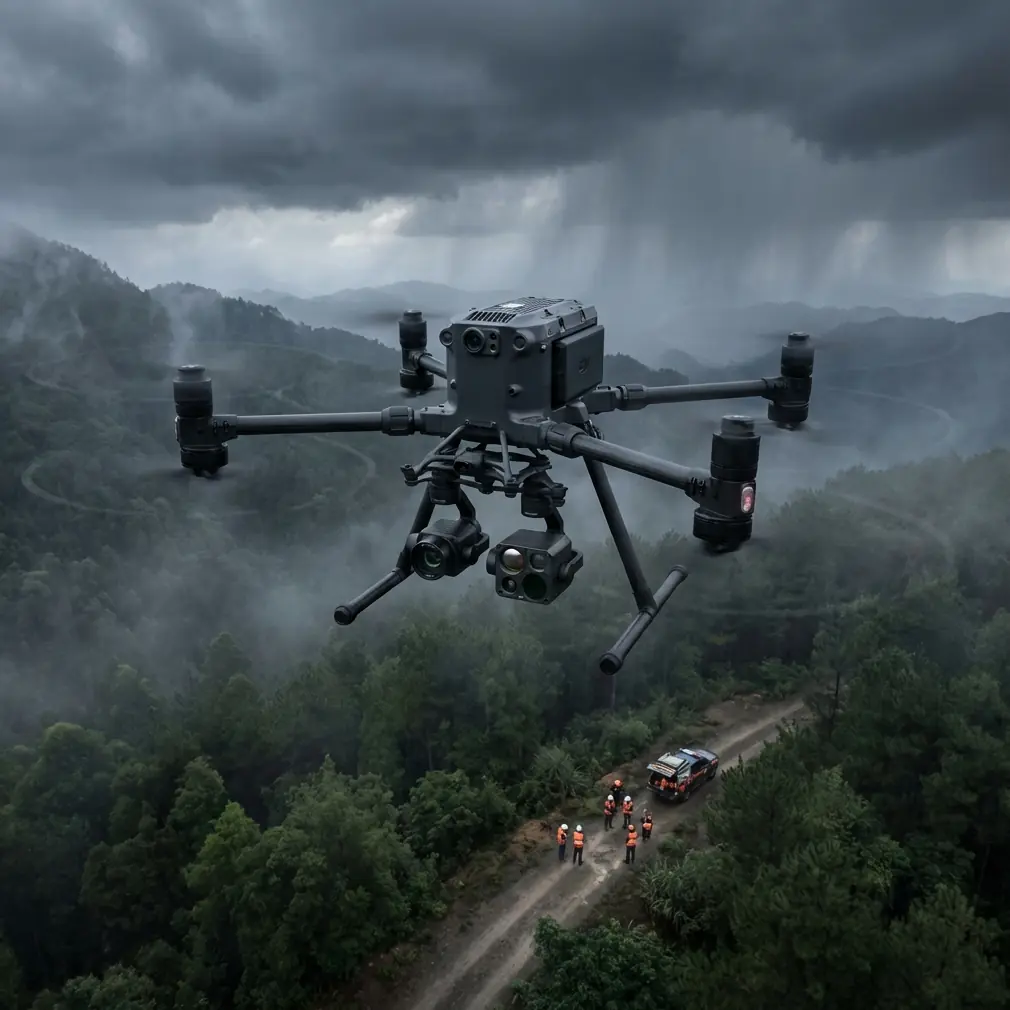
My answer is specific: for most remote coastline filming missions, the sweet spot is usually around 70 to 100 meters above takeoff point, adjusted for terrain and local airspace constraints. That altitude band gives the Matrice 400 a practical balance between framing efficiency, signal resilience, and surface detail. Go much lower and you often create unnecessary risk from gust turbulence, cliff-side rotor wash interactions, and interrupted transmission lines. Go much higher and the ocean texture begins to flatten, wave patterns lose force, and the shoreline can read more like a map than a story.
That altitude recommendation matters because coastal filming is one of the easiest places to waste the strengths of a high-end aircraft.
At 70 to 100 meters, you can usually maintain enough separation from sea spray and unpredictable updrafts while still preserving texture in breaking surf, rock formations, dune contours, and tidal seams. For photogrammetry passes, that same band can also support efficient overlap planning, especially when the objective is to produce a usable surface model of a shoreline section rather than only cinematic footage. If your mission includes GCP-backed mapping, staying in a disciplined altitude window improves consistency across image sets and reduces the mismatch that often appears when operators mix dramatic low passes with structured survey legs.
This is where the Matrice 400’s transmission architecture becomes operationally significant rather than just a spec sheet talking point. In remote coastal environments, O3 transmission is not simply about range. It is about how the link behaves when terrain refuses to cooperate. A long beach can fool pilots into thinking they have clear line of sight, but the minute the route bends around a bluff or drops behind a rocky outcrop, you are dealing with partial screening and multipath effects. A stable digital link gives the crew more confidence to hold the planned route instead of making reactive, picture-driven corrections that burn time and battery.
That same stability also changes how you compose. On a coastline mission, you often need to hold a lateral track parallel to the shore for longer than you would in most inland environments. If the downlink becomes inconsistent, operators tend to climb to recover signal, which usually degrades the footage by reducing relief and visual drama. When the link is stronger, you can stay in the altitude band that actually suits the shot.
Security also matters more in these operations than many crews admit. Remote filming is often assumed to be low risk from a data perspective because the location feels isolated. In practice, those missions can involve sensitive environmental surveys, infrastructure adjacency, privately owned coastal land, or protected marine zones. AES-256 support is not a decorative feature in that context. It is part of a professional handling standard. If your Matrice 400 mission is collecting thermal overlays, topographic reference, or route intelligence for a client operating in a controlled coastal area, encrypted transmission becomes part of the job, not an optional checkbox.
Thermal capability deserves special attention here because coastlines are not only visual subjects. They are thermal environments with their own logic. Early morning rock shelves hold heat differently than wet sand. Freshwater runoff can create faint temperature separations where it meets the sea. Search work, wildlife monitoring, and erosion assessment all benefit from understanding thermal signature patterns, especially during low-angle sun periods when visible imagery alone can hide more than it reveals.
For a remote crew, the operational value of thermal is that it helps validate what the eye thinks it sees. A dark patch on a cliff face may look like shadow in RGB and active moisture in thermal. A human presence near drift lines or inaccessible coves may be easier to isolate when ambient temperatures create enough separation. The Matrice 400 becomes more than a camera carrier when it can support that layered interpretation. It turns one deployment into a richer data collection event, which matters when the launch point is difficult to reach and a second trip is costly in time.
Battery workflow is another area where the aircraft’s design changes real-world planning. Hot-swap batteries are not glamorous, but on a coastline they can be the difference between a tight mission sequence and a broken one. If you have already hiked equipment to a cliff-top launch point, set up a safe staging area, checked wind at multiple elevations, and coordinated observers, every unnecessary pause erodes the margin you fought to create. Hot-swap capability allows you to keep the aircraft and payload workflow moving with less disruption. That matters when light is changing quickly or when tides are turning a location from usable to inaccessible.
The coastal use case makes this especially practical. Many shoreline stories are time-bound. You may need one pass at low tide to reveal rock channels, another as the water advances, and a thermal set just after sunrise before the surface equalizes. Fast turnaround between sorties keeps the sequence coherent. It is not just about endurance in the air; it is about continuity on the ground.
There is also a deeper reason why the Matrice 400 suits remote coastline work: it supports discipline. Bigger, more capable aircraft tend to expose whether a crew has a process or only enthusiasm. On a remote marine edge, process wins.
A clean mission starts before takeoff. I recommend dividing the coastline into three operational layers rather than treating it as one long scenic corridor.
First, the establishing layer. This is where the 70 to 100 meter altitude band usually works best. Use it to define shoreline geometry, surf energy, access paths, vegetation boundaries, and man-made features such as piers, breakwaters, or sea walls. This footage becomes the structural backbone of the story.
Second, the detail layer. Drop lower only where terrain, wind, and spray conditions remain predictable. Use these passes sparingly. The purpose is not to prove how close you can fly. It is to isolate moments the higher layer cannot resolve: water movement through a notch, wave strike against stacked rock, or texture on an eroded edge. If you are also collecting survey-grade imagery, keep this layer separate from your mapping run to protect consistency.
Third, the analytical layer. This is where thermal, photogrammetry, and GCP-informed capture strategies earn their keep. If the assignment goes beyond pure filmmaking, this layer is what transforms attractive footage into operationally relevant content. Coastal erosion teams, habitat researchers, and infrastructure managers do not just want beautiful oblique shots. They want spatially reliable views they can compare over time.
That is also where BVLOS planning enters the discussion, even if your specific mission remains within visual line of sight. Remote coastlines naturally tempt operators into long linear routes. The aircraft can handle distance, but the route still has to be framed by procedures, observers, regulations, terrain analysis, and contingency landing options. Thinking in BVLOS terms sharpens the mission whether or not the authorization applies. It forces you to ask smarter questions: where are the dead zones behind headlands? Where can the crew reposition without losing command continuity? What happens if the return path faces stronger onshore wind than the outbound leg?
Too many failed coastal flights come from a simple misread of wind geometry. Pilots check the launch point, see acceptable conditions, and assume the route is safe. But cliffs create local acceleration zones. Gullies vent crosswinds. The lee side of a ridge may feel calm until the aircraft slides a few meters and enters a turbulent seam. With the Matrice 400, the smarter move is to use your first leg as a diagnostic pass. Hold your planned working altitude, study drift corrections, watch gimbal behavior, and verify that signal quality remains strong where the shoreline curves. Then decide whether the dramatic low section is worth the extra complexity.
If your mission includes both footage and terrain modeling, do not improvise the overlap pattern in the field. Pre-plan it, and use visible shoreline markers plus GCP placement where practical. Coastlines are notoriously deceptive in reconstruction because repeating textures like sand, foam, and rock can produce alignment ambiguity. A disciplined capture grid, consistent altitude, and well-considered GCP distribution can dramatically improve your output. This is one of those areas where a powerful aircraft can either amplify good fieldcraft or amplify poor habits.
For teams working with clients in remote marine regions, communication matters too. I often advise establishing a one-page flight logic brief before the mission: target altitude band, planned orbit or parallel-track method, observer positions, battery swap sequence, thermal timing window, and return thresholds tied to wind and signal quality. It sounds basic, but it prevents the familiar coastal pattern where the operation slowly drifts from planned capture to opportunistic chasing of waves and light. If you want help shaping that workflow for your own site, you can message a remote-flight planning specialist.
The Matrice 400 is at its best on the coastline when it is used as a disciplined platform, not a brute-force one. Its value shows up in the combination of stable O3 transmission for long lateral tracking, AES-256 for sensitive mission security, hot-swap batteries for continuity, and payload flexibility that lets thermal and visual data reinforce each other. Those are not abstract features. On a remote shore, they directly influence whether you come back with fragmented clips or a coherent mission result.
So if you are preparing to film a remote coastline, start with the flight profile, not the camera settings. Build your mission around a stable working altitude of roughly 70 to 100 meters, then justify every lower pass against wind, spray, terrain, and objective. Use transmission strength to preserve composition rather than rescue bad planning. Treat thermal as a second layer of understanding, not a novelty. And if mapping is part of the deliverable, protect consistency with disciplined altitude control and GCP-aware capture.
That is how you use a Matrice 400 like a professional in coastal terrain. Not by flying harder, but by flying with intent.
Ready for your own Matrice 400? Contact our team for expert consultation.