Matrice 400 in Low-Light Coastal Work: What Actually
Matrice 400 in Low-Light Coastal Work: What Actually Matters in the Air
META: Specialist review of Matrice 400 for low-light coastline operations, with practical insight on orthophoto verification, changing weather, traceable site records, and industrial UAV workflow.
By Dr. Lisa Wang, Specialist
Most drone discussions about coastal filming drift into image quality and stop there. That misses the hard part. Along a coastline, especially in low light, the aircraft is not just collecting beautiful footage. It is trying to hold a stable, trustworthy record over water, reflective surfaces, shifting wind, and fading contrast. If the mission also supports survey, construction oversight, shoreline documentation, or land-management reporting, the standard for “good enough” changes fast.
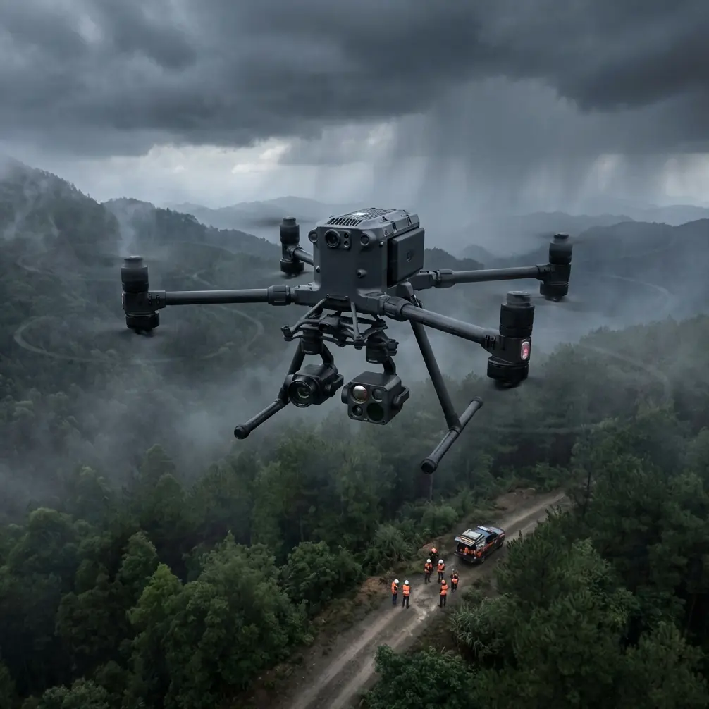
That is where the Matrice 400 becomes interesting.
Not because it promises cinematic romance at dusk, but because low-light coastal work is usually a compound job. You may need visible imagery for stakeholders, orthophoto-grade coverage for traceable documentation, thermal signature data to separate wet and dry surfaces or reveal drainage patterns, and a transmission link strong enough to keep the crew confident as weather starts changing offshore. On paper, many platforms sound capable. In practice, the test comes when the environment stops cooperating.
A useful way to judge the Matrice 400 is not by marketing categories, but by whether it fits the operational lessons already established in UAV low-altitude remote sensing. One reference stands out here: a land consolidation monitoring study that argued high-resolution UAV orthophotos offer a practical answer when there is no effective way to monitor construction progress at the necessary tempo. That point may sound narrow, but it matters well beyond inland earthworks. Coastal operations face the same problem: managers need a reliable method to verify what changed, where it changed, and whether the work matched the intended design.
The study is direct on why UAVs work in this role. Low cost and short cycle were part of the argument, but the more valuable takeaway was methodological: high-resolution orthophoto can be used to monitor implementation progress dynamically. Dynamic is the key word. Along a shoreline, especially during civil, environmental, or land-restoration work, one flight is rarely enough. Tides shift. Light collapses early. A sand edge or drainage cut that looked distinct at one hour may flatten visually by the next. The Matrice 400 makes sense if it can support repeatable capture under those unstable conditions, not just isolated hero shots.
That brings us to traceability, a point the reference material treats as operationally critical. It explicitly notes that digital orthophoto supports the authenticity of site conditions and provides reliable evidence for future land disputes. This is not abstract bureaucracy. Anyone documenting coastline modification, revetment progress, erosion-control work, access roads, culverts, or reclaimed surfaces knows that later questions often hinge on what the site actually looked like on a specific date. If your low-light mission gathers visually pleasing footage but cannot be tied back to a defensible record, its value drops sharply.
The paper gives concrete examples of monitored works: 3 culverts, 13 bridges, and 9 sluices, along with road leveling totaling 5,410 m and newly built or rebuilt roads reaching 63,193 m. Those numbers are not just engineering trivia. They show that UAV monitoring becomes useful when a project contains many distributed elements that are difficult to verify quickly from the ground. Coastline projects often share that same geometry. You may be dealing with scattered drainage assets, revetment sections, access paths, fill boundaries, and disturbed edges spread over kilometers. A Matrice 400 mission in low light should therefore be assessed on whether it can keep those features legible and geospatially useful as ambient conditions deteriorate.
This is where photogrammetry discipline enters the conversation. The aircraft alone does not guarantee a trustworthy outcome. For coastal recording that may later feed engineering review, environmental reporting, or claims analysis, you still need proper overlap, disciplined flight planning, and where accuracy demands it, GCP deployment. The Matrice 400 is best understood as the airframe that helps you hold those standards under more difficult conditions. That is a stronger claim than saying it “takes good images.”
I saw this firsthand during a low-light shoreline mission that started in relatively calm conditions and changed character halfway through. The brief looked simple enough: capture oblique coastline footage for stakeholders, gather nadir coverage for map products, and run a thermal pass over a wet transition zone before sunset disappeared entirely. About twenty minutes in, the weather shifted. Wind off the water strengthened, the horizon dulled into a gray band, and surface reflections became inconsistent from one leg to the next. The sort of change that does not always trigger a dramatic stop order, but absolutely erodes data quality if the platform or workflow is fragile.
This is the kind of moment where the Matrice 400’s industrial design matters more than spec-sheet aesthetics. Stable transmission is essential when the aircraft is working beyond comfortable visual contrast. O3 transmission, paired with secure AES-256 handling, is not just a talking point for enterprise brochures. In real operations, it means the crew keeps confidence in command continuity and feed integrity while the atmosphere gets messy. For civilian inspection and survey teams operating around infrastructure, shoreline works, or restoration zones, that continuity supports better decision-making in the exact minutes where a mission can slide from productive into risky guesswork.
The battery system matters too, particularly on coastline work where conditions can force adjustments mid-plan. Hot-swap batteries sound like a convenience feature until you are running a sequence that includes visual passes, thermal signature collection, and an orthophoto segment that should be completed in a narrow light window. Being able to recover, rotate, and relaunch with less disruption protects consistency. On time-sensitive survey jobs, fewer interruptions can mean the difference between a coherent map set and a patchwork assembled under different light states.
Now add the low-light requirement. Coastlines are hard on sensors because they strip away contrast where you need it most. Water, wet sand, concrete edges, and vegetated boundaries all respond differently as daylight fades. In those conditions, thermal signature can become more than an add-on. It can reveal drainage behavior, moisture retention, seep lines, disturbed fill, or surface temperature differences that are easy to miss in RGB imagery alone. For environmental monitoring or construction oversight near the shore, that layered dataset is often more valuable than pure visual footage. The Matrice 400’s appeal grows when it is treated as a multi-sensor working platform rather than a single-purpose camera carrier.
The original land-monitoring reference also emphasized rapid verification of whether construction followed design requirements and schedule, with the practical effect of reducing financial loss caused by insufficient oversight. That translates neatly into coastal civil work. If a contractor has graded an access route, formed a drainage feature, or completed a segment of shoreline treatment, waiting for slow manual verification can create blind spots. UAV-derived orthophoto allows faster checking of completed quantities and site status. The numbers in the source make the scale clear: beyond bridges and culverts, it tracked road works in the tens of thousands of meters. A platform like the Matrice 400 becomes relevant when managers need that same ability to move from scattered field impressions to measurable, current evidence.
There is also a subtle but crucial point about authenticity. In contested or high-scrutiny environments, “we inspected the site” is weak. A dated, georeferenced, high-resolution image set tied to repeatable flight parameters is stronger. Add GCPs where needed, and your coastal record becomes harder to challenge. This matters for land adjustment, habitat restoration, shoreline stabilization, and contractor progress reviews. The Matrice 400 does not replace survey method. It enables survey-grade discipline to continue later in the day, in lower contrast, and under less forgiving weather.
What about BVLOS? For civilian commercial users, BVLOS always sits inside regulatory and procedural boundaries, but it is still part of the strategic picture. Coastline operations can quickly outgrow short-range manual patterns, especially where access is poor or terrain interrupts line of sight. A platform architecture suited to enterprise transmission reliability and broader mission planning is naturally more aligned with that future. Even if today’s job remains within standard visual operating constraints, buyers looking at the Matrice 400 are often thinking one step ahead: can this aircraft integrate into a maturing industrial workflow rather than remain trapped in ad hoc capture missions?
That question matters because low-light coastal work is rarely a one-off creative outing. It often feeds a larger program: recurring erosion baselines, pre- and post-construction comparison, wetland edge monitoring, access-road verification, embankment inspection, or public reporting. The reference study’s core value proposition was speed plus usable evidence. Not merely speed, and not imagery for imagery’s sake. Evidence. That is the correct lens for evaluating Matrice 400.
If you want a practical benchmark, ask whether your current drone workflow can do four things in one evening coastal mission:
- Hold stable transmission as visibility degrades and weather shifts.
- Capture imagery suitable for orthophoto production, not just screen viewing.
- Add thermal signature data that improves interpretation of water, moisture, or structural transitions.
- Preserve continuity across sorties without blowing up the timing window.
If the answer is inconsistent, the Matrice 400 deserves attention.
One more operational note: low-light coastline filming often reveals workflow weaknesses before hardware weaknesses. Teams chase dramatic angles and neglect reference passes. They skip GCP planning because the shoreline “looks simple.” They underestimate how fast changing weather alters reflective surfaces. They treat thermal as secondary until the visible dataset becomes ambiguous. The strongest use of Matrice 400 is therefore methodical. Fly for record first, interpretation second, beauty third. You will still get compelling visuals, but you will also leave with something a project manager, survey lead, or dispute-resolution team can actually use.
That is the real lesson echoed by the land-consolidation monitoring research. UAV remote sensing proved feasible not just because it was faster, but because it produced high-resolution orthophoto with enough truth value to verify work and support later traceability. The mention of future land disputes in the source is especially telling. Good drone operations are not only about what you can see today. They are about what you can prove six months from now.
For teams planning coastline documentation with the Matrice 400, that should be the standard. Use the aircraft’s industrial transmission, secure data handling, hot-swap endurance, and multi-sensor flexibility to create records that survive scrutiny. Low-light conditions are not merely an obstacle. They are the filter that reveals whether your platform is fit for professional fieldwork.
If you are mapping shoreline change, documenting coastal construction, or refining a low-light survey workflow and want to compare mission setups, you can reach out here: message Dr. Lisa Wang’s team.
Ready for your own Matrice 400? Contact our team for expert consultation.