Matrice 400 Field Report: What Aircraft Load Theory Tells
Matrice 400 Field Report: What Aircraft Load Theory Tells You About Filming Rugged Coastlines
META: An expert field report on using Matrice 400 for coastline filming in mountain terrain, linking aircraft load behavior, structural thinking, transmission reliability, and practical mission planning.
I’ve spent enough time around drones in ugly terrain to know that the glossy brochure questions are rarely the ones that matter in the field. When you are filming a coastline pinned against steep mountain relief, the real issue is not whether the aircraft can hover neatly on a calm day. The real issue is what happens when the machine is repeatedly asked to absorb abrupt attitude corrections, uneven landing surfaces, gust-driven roll moments, and long mission cycles without turning a precision shoot into a recovery exercise.
That is why the most revealing way to think about the Matrice 400 is not as a camera platform first, but as a load-management system in the air.
The reference material behind this article comes from classic aircraft design texts, and while those pages were written for crewed aircraft, the engineering logic maps surprisingly well to high-end UAV operations. One passage describes a severe landing-load condition where a rearward force acting through the main wheel axle creates serious torsion at the wing root, accompanied by large shear force and bending moment. Another section discusses single-wheel landing effects, where roll moment becomes large enough to increase downward inertial loading on one side while changing the load picture across the span. If you operate in mountain coast environments, those are not abstract textbook notes. They are the reason some aircraft feel composed near touchdown and others feel like they are one awkward contact away from a maintenance event.
Why this matters for Matrice 400 missions on coastal cliffs
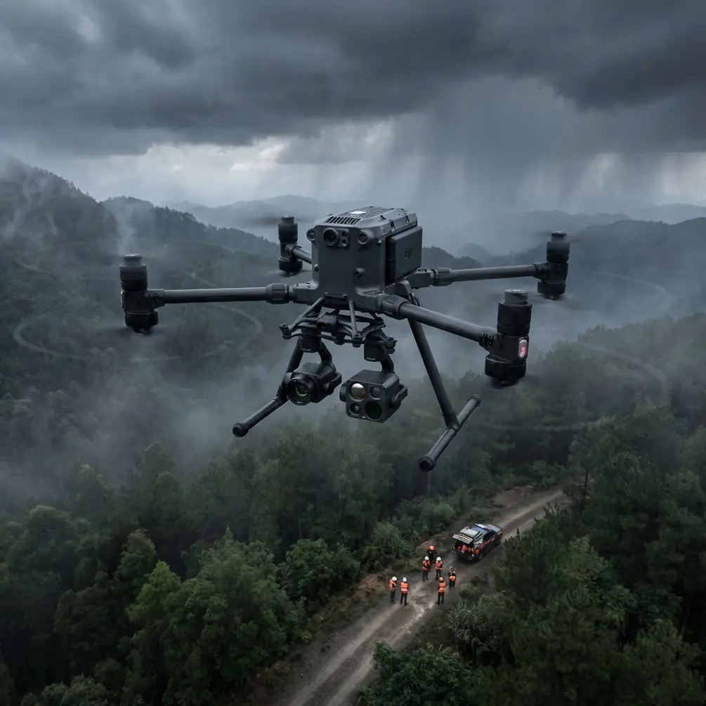
A mountain coastline creates a messy aerodynamic envelope. Wind wraps around ridgelines, lifts along rock faces, then falls apart over coves and outcroppings. During filming, you might transition from smooth tracking over water to a lateral correction near a cliff edge, then descend onto uneven ground or a compact launch pad with crosswind still present. Even on a multirotor, every one of those moments produces load paths through the frame, landing gear, propulsion mounts, gimbal support, and payload interface.
That is where the handbook’s “maximum spin-up” style landing condition becomes useful as a mental model. In the source, a rearward-acting force at the main landing wheel axis is identified as creating severe torsional demand, plus substantial shear and bending. Translate that operationally: when an aircraft touches down while still carrying horizontal energy or correcting for slope and wind, the structure is not merely dealing with vertical impact. It is dealing with twisting and asymmetric load transfer.
For a platform like Matrice 400, that matters because mountain-coast filming rarely gives you ideal pad geometry. You may be landing on compact gravel pullouts, wind-exposed ledges, or temporary surfaces near survey markers and GCP layouts. A drone that behaves well only in textbook-level touchdowns is a weak tool for this environment. A drone designed for serious enterprise work has to tolerate repeated imperfect but controlled arrivals without losing alignment, camera confidence, or calibration stability over time.
The overlooked advantage: structural discipline beats headline specs
Pilots often compare enterprise drones by payload flexibility, sensor options, or transmission range. Those are valid comparisons, but in hard terrain the quiet differentiator is structural discipline.
The second reference document, from a weight-and-balance volume, may look far removed from drone operations at first glance. It deals with component mass characteristics and tabulated notch geometries for stringers, including formulas for sectional area and a long list of dimensions. One table row lists values such as 50, 13, 65, 45 with an area of 25.77 cm², while another gives 100, 25, 68, 48 and 52.10 cm². Dry numbers, yes. But they point to a principle every serious UAV operator should respect: mass distribution and local geometry are never trivial. Small changes in cutouts, support sections, or component placement alter stiffness, strength margin, and dynamic behavior.
That same logic is central when evaluating a platform like Matrice 400 for mixed sensor work. If you are carrying a stabilized visual payload one day and a thermal package the next, the aircraft’s ability to maintain predictable balance and structural response is not a side issue. It directly affects footage smoothness, hover precision, and post-processing quality for photogrammetry.
On coastal mountain jobs, I care about whether the aircraft remains settled when the payload is working hard and the wind is trying to write its own flight plan. That is where heavier-duty enterprise aircraft tend to separate themselves from lighter competitors. Some smaller platforms can capture beautiful imagery in friendly conditions. Fewer stay equally convincing when the mission combines elevation changes, reflected glare from the water, variable wind shear, and multiple takeoff cycles in a single day.
Matrice 400 in the real workflow: not just filming, but data capture with continuity
There is another misconception worth clearing up. “Filming coastlines” sounds cinematic, but many of these operations are really hybrid missions. The client may want hero footage of sea cliffs, but they also want shoreline condition records, slope movement indicators, vegetation stress checks, and orthomosaic-ready imagery from the same deployment.
That is where Matrice 400 becomes more than a camera lifter. A serious field platform should let you move between visual inspection, thermal signature analysis, and photogrammetry without forcing a full operational reset every time conditions shift.
Thermal signature work is especially revealing on rugged coastlines. Moisture retention in rock fissures, uneven heating across exposed faces, and infrastructure anomalies near access roads or retaining structures often show up first in the thermal layer, not in RGB footage. But thermal data only becomes useful if the aircraft can hold line and altitude consistency while contending with vertical terrain and changing onshore flow.
Photogrammetry raises the bar further. If your overlaps drift because the aircraft is getting knocked around or because transmission confidence drops behind terrain masking, your map quality suffers. GCPs can rescue absolute accuracy, but they cannot repair weak image geometry caused by poor aircraft stability or interrupted execution.
That’s why transmission and command reliability deserve more attention than they usually get in marketing comparisons. In mountain coastal terrain, O3 transmission is not just a convenience feature. It is an operational asset. Clean link behavior matters when you are working near ridges where line-of-sight can degrade quickly with a single course change. Stable transmission supports better framing, safer route adjustments, and fewer compromises when you need to hold a shot while terrain is trying to break the signal path.
The same goes for AES-256. People often treat encryption as an IT checkbox, but on commercial coastline projects it can be contractually relevant. If you are filming private resort frontage, industrial shoreline assets, erosion-control structures, or sensitive infrastructure adjacent to public land, secure data handling is not decorative. It belongs in the professional baseline.
Hot-swap batteries are more valuable in the mountains than on paper
Battery conversations are usually reduced to endurance claims. That misses the practical benefit of hot-swap batteries for field crews.
On a coastline in mountain terrain, shutting down between sorties can cost more than time. It can cost your weather window. Cloud cover shifts fast. Water reflections change. Wind direction rotates around terrain. If you need to bring the aircraft down, swap power, and get back up while preserving mission continuity, hot-swap capability has outsized value.
This is especially true for repeatable filming passes and corridor-style mapping. If the light opens up for six minutes on a distant headland, you do not want a cold restart and full system interruption getting in the way. Enterprise crews understand this instinctively. The aircraft that keeps mission rhythm intact is often the aircraft that delivers the better final product, even if another model looks competitive on isolated spec points.
The load-case lesson every drone cinematographer should borrow from aircraft engineers
The aircraft-design source also highlights an effect from single-wheel landing: the induced roll moment can become large, increasing downward inertial force on one wing while altering load severity across the aircraft. That observation is gold for drone teams operating on rough edges and sloped pull-ins.
For drone work, the lesson is simple. Asymmetry is expensive.
When one side of the landing gear touches first on a tilted or unstable surface, or when a gust catches the aircraft during descent, the system experiences a moment that can ripple through the frame and payload. That may not produce obvious damage. More often, it produces something subtler: micro-disturbance in calibration, increased wear, or the kind of vibration behavior that only shows up later in footage review.
Matrice 400’s appeal in this environment is that it sits in the class of aircraft people choose when they need margin, not just capability. Margin in structure. Margin in control authority. Margin in mission continuity. That is the category that matters when you are operating above rocks and surf rather than over an open sports field.
Where Matrice 400 stands out against lighter rivals
Here is the blunt comparison. Many competing platforms are good at being portable. Fewer are genuinely comfortable as all-day industrial flight tools in severe terrain.
The difference shows up in three places:
Recovery from disturbed air
Mountain coastlines generate abrupt lateral and vertical disturbances. A more substantial enterprise platform generally holds track and framing better than lighter aircraft that need more visible correction.Payload confidence
Once thermal, zoom, or mapping payload requirements enter the mission, the balance-and-stiffness question becomes real. The structural thinking reflected in the reference material—mass properties, section geometry, local load effects—is exactly what separates a purpose-built work platform from a drone that merely accepts accessories.Turnaround under field pressure
Long coastal assignments rarely follow a single neat sortie. Hot-swap batteries, strong transmission behavior, and predictable system handling often make the operational difference between “we got the scene” and “we almost got it.”
That does not mean Matrice 400 is the right answer for every operator. If your work is short-range, low-wind, and purely visual, a smaller aircraft may be enough. But if you are building deliverables across video, inspection, thermal signature, and photogrammetry in terrain that punishes hesitation, the bigger professional platform starts to justify itself quickly.
Practical mission setup for a mountain coastline shoot
If I were preparing Matrice 400 for this type of assignment, I would think in layers rather than in a simple checklist.
First, define whether the mission is cinematic, survey-grade, or mixed. That determines whether the day revolves around fluid gimbal movement, strict overlap discipline, or both.
Second, place GCPs only where they can actually survive the terrain logic. On narrow coastal access points, crews often set control where it is convenient rather than where sightlines remain clean. That leads to avoidable quality issues later.
Third, treat touchdown planning as seriously as the flight path. The load-case references are a reminder that landing forces are not an afterthought. Choose surfaces that reduce asymmetric gear contact and avoid rushed recoveries in rotor-wash turbulence near cliffs.
Fourth, use transmission planning proactively. O3 performance helps, but no link is magic when terrain masking becomes aggressive. Build flight lines that preserve signal quality where possible instead of assuming the aircraft will solve every geometry problem for you.
Finally, keep the data chain professional. If the operation includes sensitive sites or client restrictions, AES-256-backed workflows and disciplined media handling should be part of the mission architecture from the start, not patched in later.
If your team is sorting through payload combinations or mission planning for this kind of terrain, I’d suggest using this direct field contact for technical coordination: message a Matrice operations specialist.
The bigger point
What I like about reading old aircraft design material alongside modern drone practice is that it strips away hype. The fundamentals have not changed. Forces still travel through structures. Center of gravity still changes the severity of a load case. Roll moments still punish asymmetry. Local geometry still affects stiffness and durability. And the aircraft that handles those realities best usually produces the calmer, safer, more repeatable mission.
That is the frame through which I would judge Matrice 400 for coastline filming in mountain terrain.
Not by a single spec sheet promise. By how confidently it handles the ugly parts of the job: uneven touchdowns, payload variation, cross-slope recovery, long sortie chains, and mixed-data capture under shifting wind and light.
That is where professional aircraft earn their keep.
Ready for your own Matrice 400? Contact our team for expert consultation.