How I’d Film a Difficult Coastline with the Matrice 400
How I’d Film a Difficult Coastline with the Matrice 400
META: Expert field guide to filming coastlines with the Matrice 400, including weather shifts, transmission stability, thermal workflow, photogrammetry planning, and why integrated aerial imaging changes real-world operations.
Coastline work has a way of exposing weak assumptions.
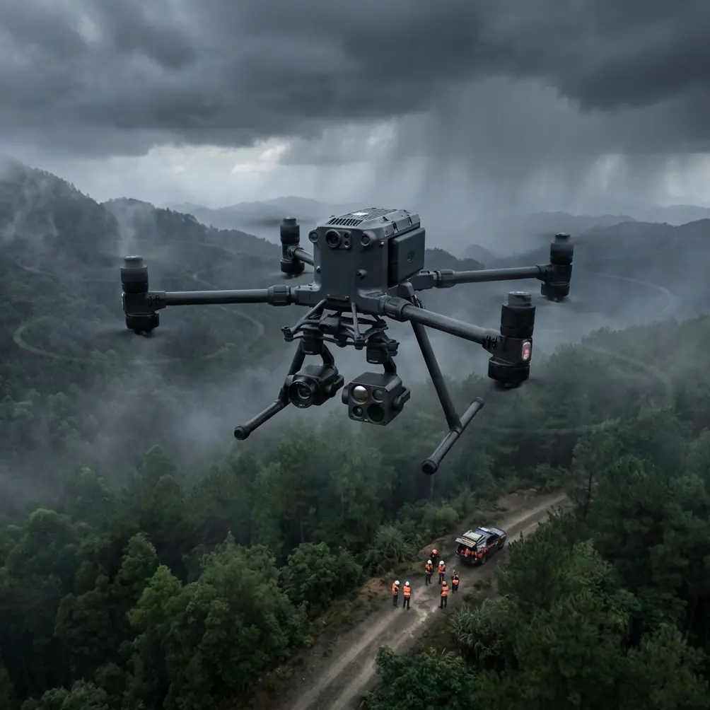
A mission can look simple on the map: trace a sea wall, capture cliffs at golden hour, build a clean visual record for stakeholders, maybe add a thermal pass and a photogrammetry set while you are there. Then the site reminds you that land and water create their own rules. Wind bends around rock faces. Salt haze softens contrast. Signal paths change as the aircraft rounds an outcrop. Light can flip from flat to brilliant in minutes. If you are flying the Matrice 400 in that environment, the aircraft matters, but the workflow matters more.
That is the lens I would use for filming a coastline in complex terrain with the M400: not as a beauty flight, but as an integrated aerial data mission where footage, mapping, and inspection all have to hold together under pressure.
Start with the job, not the drone
Before takeoff, define what the client actually needs from the coastline mission.
For some teams, the priority is cinematic documentation: showing erosion, access roads, marinas, retaining walls, or beachfront assets in a way that non-technical decision-makers can grasp instantly. For others, it is asset condition. That is where thermal signature work may reveal moisture intrusion, heat anomalies in coastal facilities, or drainage issues invisible in RGB imagery. In survey-oriented projects, the same flight window may need to support photogrammetry outputs with proper overlap and GCP alignment.
This is where many operators waste time. They treat filming, inspection, and mapping as separate events when the site conditions favor a consolidated plan. The stronger approach is to design one mission architecture with separate capture layers.
I typically break a complex coastline task into four parts:
- Establishing visual footage
- Low oblique structural passes
- Thermal or specialty sensor pass
- Photogrammetry grid, tied to GCPs where required
That sequence is not arbitrary. Coastal weather is often most forgiving early, while thermal usefulness may improve as surfaces warm or cool depending on the target. Mapping runs, by contrast, demand consistency more than drama.
Why coastline filming is really about perspective control
The operational challenge along cliffs, inlets, and developed shoreline is not just wind. It is perspective drift.
A beachfront property, harbor structure, or escarpment can look straightforward from one angle and completely misleading from another. That matters because aerial imaging is often used to help people make decisions faster. We have a useful reference point from the real estate world: in February 2016, Keller Williams formally partnered with DroneBase, integrating one-week aerial service ordering into its product listing flow. The reason that matters is not nostalgia. It is proof that once aerial imagery becomes frictionless inside an operational platform, people use it to accelerate decisions.
According to the source material, agents reported that image and video capture produced through the DJI and DroneBase workflow made listings easier to understand and helped deals move faster. That operational lesson translates directly to coastline missions. If your footage makes shoreline condition, access limitations, slope geometry, or structural context obvious at a glance, your client can act sooner. If the footage is attractive but ambiguous, you have created content, not clarity.
With the Matrice 400, I would plan each shot around that standard. Every pass should answer a question:
- What is the relationship between the structure and the waterline?
- Where is the erosion advancing?
- How does terrain restrict access?
- Which surfaces need closer inspection?
- What can be shared quickly with remote stakeholders without additional explanation?
That last point matters more than many pilots admit. DroneBase’s model succeeded in part because it made aerial material easier to share and easier to use. The source specifically emphasizes more intuitive property viewing and more convenient sharing. In a coastline workflow, that same principle should guide your file structure, shot sequencing, and deliverable packaging from the beginning.
My flight planning method for the M400 on a coastal site
The M400 earns its place when conditions are messy and the mission is layered. Here is how I would structure the operation.
1. Build a terrain-first route
Do not draw a neat line along the shore and assume it will fly cleanly. Coastal terrain creates localized wind behavior, dead air pockets, and sudden lateral gusts around ridgelines.
I start by identifying:
- cliff edges and bowl-shaped recesses
- radio shadow zones behind rock formations
- wet reflective surfaces that may confuse visual interpretation
- launch and recovery positions with multiple escape paths
- emergency diversion points inland
If the coastline wraps around headlands, I split the mission into sectors. That keeps command, visibility, and battery logic cleaner than trying to force one long continuous run.
2. Assign capture modes by sector
One sector might be designed for smooth lateral reveal footage. Another might require slower inspection orbits around coastal infrastructure. Another may be reserved for mapping.
This is also where O3 transmission and encrypted links such as AES-256 become practical rather than theoretical talking points. Along rugged shorelines, signal integrity is not only about range. It is about confidence when the aircraft moves across mixed terrain and reflective water surfaces. If the mission involves sensitive infrastructure, secure transmission standards matter for data governance as much as for flight control discipline.
3. Decide where GCPs actually add value
Not every coastline shoot needs full survey control. But when the final product includes measurement-grade photogrammetry, GCP placement can rescue the project from accumulated error.
The mistake is placing GCPs where they are easy, not where they improve geometry. On a coastal job, I want GCPs spread across elevation changes and longitudinal distance, not clustered near a parking area. If the brief includes sea walls, road approaches, drainage channels, or built features near the shoreline, those become anchor zones for useful control.
4. Preserve battery flexibility
Hot-swap batteries are not a convenience on coastal work. They are a tempo tool. Weather windows can tighten quickly, and the ability to turn the aircraft around without a cold restart can preserve continuity in both imaging and team rhythm.
That matters when the site changes character mid-operation.
The weather changed halfway through. Here is what I would do.
On one type of coastline mission, the day often begins with soft onshore air and decent visibility. Then the sea breeze firms up, cloud cover shifts, and the aircraft starts encountering variable crosswind loads near rock faces. That is exactly where a heavy-lift enterprise platform needs to feel predictable.
If I were flying the M400 and the weather turned halfway through, I would not try to “push through” the original shot list. I would immediately re-prioritize outputs by degradation sensitivity.
First, I would finish any essential inspection or documentation passes that still benefit from current conditions. Then I would postpone the most aesthetically demanding cinematic runs, because those are often the first to suffer when wind gusts begin affecting micro-smoothness in tracking shots.
At the same time, some tasks remain viable or even become more useful. Thermal signature capture, depending on the target and environmental timing, may still offer strong value after a visible-light sequence loses polish. Similarly, straight-line photogrammetry at safe altitude may remain operationally efficient even when low, sculpted shoreline moves are no longer worth the risk or effort.
This is where an enterprise mindset separates itself from hobby habits. The goal is not completing the exact plan. The goal is protecting the mission outcome.
Why the old aviation reference still teaches something useful
One of the stranger but surprisingly relevant reference points here comes from the aircraft starter-system material in the second document. It describes a staged electrical approach in which power is not applied all at once; instead, the system transitions from a lower effective voltage condition to full voltage after switching, improving starting characteristics and reliability. The document even notes that the parallel phase represents 1/2 of the voltage applied to the motor before full voltage is introduced, and that high-voltage electrical starting improves power, efficiency, final rotor speed, and remaining torque.
That is not a drone feature description. But operationally, it points to a discipline that matters in the field: controlled power management improves reliability.
For Matrice 400 crews, the lesson is simple. Coastal missions punish rushed system behavior. You want stable startup checks, disciplined battery handling, clean payload initialization, and deliberate transition into the highest-demand segments of flight. In practice, that means not launching straight into the most complex cliffside line before verifying aircraft response, payload behavior, transmission stability, and environmental drift in a safer envelope.
The same engineering logic applies at the mission level. Stage the work. Do not front-load all the hardest tasks into the first minutes simply because the battery is fresh. Build confidence, validate the conditions, then escalate complexity.
How I capture footage that stakeholders can actually use
A coastline film package for commercial stakeholders should do more than look polished. It should compress site understanding.
I would structure the capture like this:
Opening context pass
A medium-altitude reveal that shows the full relationship between coastline, structures, roads, and exposure. This is the shot decision-makers rely on first.
Oblique shoreline tracking
Long lateral moves parallel to the coast, keeping the frame useful for reading slope stability, revetments, or beach change over time.
Cross-angle detail sequences
Shorter, slower passes at angles that expose hidden faces of cliffs, retaining walls, stairs, jetties, or rooflines.
Vertical relationship shots
Top-down or steep oblique imagery to support layout analysis and future photogrammetry stitching.
Thermal overlay capture
If the payload supports it, use thermal passes to isolate anomalies that deserve engineering follow-up.
This integrated style echoes the underlying value shown in the DroneBase reference. When a platform combines aircraft capability with a workflow that makes outputs easy to request, understand, and share, the user sees productivity gains rather than just prettier visuals. The source material explicitly ties that combination to higher-quality aerial imagery and improved sales efficiency. In coastline work, the equivalent benefit is faster reporting, clearer maintenance prioritization, and less back-and-forth between field teams and remote reviewers.
If your team needs a second set of eyes on mission structure or payload planning, I’d usually suggest sending the route sketch and site constraints first through direct field coordination on WhatsApp so the capture logic can be fixed before anyone travels to the launch point.
BVLOS, transmission, and complex terrain
Some coastal operations naturally push toward longer corridor-style work. If the mission framework and local regulations support BVLOS, the M400 becomes more than a camera platform. It becomes a continuity platform for large linear assets and hard-to-access shorelines.
But BVLOS over coastlines is not simply a longer VLOS mission. You need a stronger preflight model of terrain shielding, contingency routing, recovery zones, and communication integrity. O3 transmission matters here because consistent link behavior is the difference between calm execution and constant operational hesitation. Add AES-256 into the discussion when infrastructure footage or sensitive commercial data is involved, and the aircraft starts fitting into a broader enterprise workflow rather than living as an isolated flight tool.
That distinction is easy to miss. Mature drone operations are less about “what the drone can do” and more about “what the organization can rely on the drone to deliver repeatedly.”
Final advice for filming coastlines with the Matrice 400
If you are using the Matrice 400 on a difficult shoreline, think like an operator first and a filmmaker second.
Use footage to remove ambiguity.
Use thermal only where it changes the maintenance conversation.
Use photogrammetry when measurement matters, and place GCPs where they strengthen the model rather than where they are convenient.
Use hot-swap battery capability to protect momentum.
Use secure, stable transmission to maintain confidence when terrain and water start complicating the link.
And when the weather turns, do not defend the original plan. Redesign the sequence around what the site will still give you safely.
The strongest coastal missions are rarely the most dramatic. They are the ones that leave the client with a sharper understanding of the shoreline than they had before the aircraft launched. That has been true since aerial imaging first became embedded into real operational workflows, as seen when Keller Williams folded DroneBase service access into its own listing environment back in 2016. The drone was valuable, yes. But the real gain came from making visual information easier to obtain, easier to interpret, and easier to act on.
That is still the standard. The Matrice 400 just gives you a more capable way to meet it on harder terrain.
Ready for your own Matrice 400? Contact our team for expert consultation.