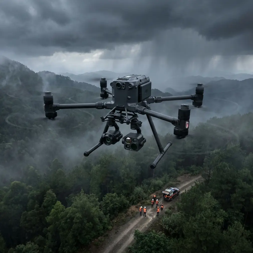
Matrice 400 in Mountain Construction Filming
Matrice 400 in Mountain Construction Filming: What a 2010 Photogrammetry Standard Still Gets Right
META: A field-based case study on using Matrice 400 for mountain construction filming, grounded in low-altitude digital aerophotogrammetry standards, flight prep discipline, and practical mapping workflow.
Mountain construction sites punish weak workflow long before they punish weak aircraft.
That is the real story behind the Matrice 400 in this kind of environment. Yes, the platform matters. Stability matters. Transmission matters. Battery strategy matters. But on steep terrain, with dust, broken surfaces, temporary access roads, and constantly changing cut-and-fill geometry, the difference between a useful flight and a costly reshoot usually comes down to field discipline.
A surprisingly relevant reference point is not a glossy product sheet, but a Chinese surveying standard published on 2010-08-24 and implemented on 2010-10-01: CH/Z 3004-2010, Specifications for field work of low-altitude digital aerophotogrammetry. Even from the limited front-matter available, the message is clear. Low-altitude aerial work is not just about flying. It is about organized field operations, image material requirements, and process control that protects data quality before the aircraft ever leaves the ground.
For anyone evaluating the Matrice 400 for filming and documenting mountain construction, that standard offers the right lens. The aircraft is only one part of the chain. The field method is what turns flights into reliable visual records, progress maps, and defendable site documentation.
A mountain site is not a normal filming job
Let me frame this as a practical case.
A contractor needs recurring aerial coverage of a mountainside road expansion and retaining structure project. The brief sounds simple enough: capture cinematic overviews for stakeholders, document weekly progress, and produce photogrammetry-grade imagery over selected zones where terrain cuts are changing fast.
In flat terrain, teams can sometimes get away with loose planning. In the mountains, that falls apart quickly.
Light shifts unevenly across slopes. Dust hangs in the air after truck movement. Elevation changes distort visual judgment. Narrow benches limit takeoff options. Wind can be calm at launch and unstable near exposed ridgelines. The same site also needs two different output types: polished footage for reporting and repeatable image capture for measurement.
This is exactly where the Matrice 400 becomes interesting—not because it magically solves every problem, but because it can support a disciplined operation that serves both filming and survey-grade documentation.
Why the 2010 aerophotogrammetry standard matters to a modern drone team
The standard’s title alone tells you where the emphasis should be: field work of low-altitude digital aerophotogrammetry.
That phrase matters. “Field work” is not a minor detail. It means the job begins with how the crew prepares, checks, records, and executes. It is a reminder that aerial imaging over a mountain construction site should be treated as a technical field operation, not a casual content capture session.
Even the fragmented table-of-contents text hints at a section dealing with requirements for aerial photography materials. Operationally, that is huge. On a live construction site, poor image material is not just a quality issue. It can break downstream outputs:
- inconsistent overlap can damage photogrammetry reconstruction
- smudged optics can reduce edge sharpness on earthworks and rebar zones
- inconsistent altitude over steep ground can distort scale consistency
- poorly logged field conditions can make weekly comparisons unreliable
The Matrice 400 should be deployed with this old but durable principle in mind: image collection must be planned around output quality, not around whatever looks good in the monitor on the day.
The pre-flight cleaning step most crews rush through
You asked for a safety-focused pre-flight cleaning detail, and this deserves more attention than it usually gets.
Before any mountain construction mission, my first hard stop is a cleaning inspection of the aircraft’s external sensing and imaging surfaces. That means camera glass, downward and forward sensors, thermal payload windows if fitted, landing gear contact areas, battery interfaces, and airframe seams where fine dust can settle.
On mountain sites, dust is not cosmetic. It is operational contamination.
A thin film on an optical surface may not be obvious on a small controller display, but it can reduce image consistency across a mapping block. Dirt around obstacle sensing or positioning-related components can also degrade confidence in low-speed maneuvering near uneven ground and temporary structures. If you are collecting thermal signature data around exposed utilities, recently poured sections, drainage runs, or equipment staging areas, a dirty lens can also produce misleading interpretation.
This is where the Matrice 400’s professional design should be treated as a reason for stricter habits, not looser ones. Advanced systems invite reliance. Good crews resist that temptation.
My preferred sequence is simple:
- Dry inspection first, looking for dust, grit, moisture, and fine scratches.
- Clean optics and sensor covers with approved materials only.
- Check battery contacts and seating areas for debris before installation.
- Confirm payload mounting surfaces are clean and locked.
- Recheck after engine-driven equipment or truck convoys stir up dust near the launch zone.
That last point is often missed. On mountain projects, a drone can be perfectly clean during setup and contaminated again five minutes later because a dozer climbed past the launch point.
How Matrice 400 fits a dual-role mission: filming plus photogrammetry
Construction clients often ask for one drone to do everything. Usually that is unrealistic. What the Matrice 400 can do well, though, is anchor a workflow that separates creative capture from measurement capture without changing aircraft class or retraining the whole team around different operational logic.
For the filming side, the aircraft’s transmission reliability matters. In mountain work, signal behavior is shaped by terrain masking, rock faces, and line-of-sight interruptions. This is why O3 transmission is more than a spec-sheet phrase in the field. It has direct operational significance: it helps maintain a more stable link when the aircraft’s route moves across broken terrain or when the pilot is forced to work from a constrained launch area rather than the geometrically ideal spot.
That does not make the mission immune to terrain shielding, of course. It simply gives the crew a stronger communication backbone for controlled visual work around slopes, stockpiles, and partially completed structures.
For the documentation side, the real value is in repeatability. If the team is flying a weekly progress corridor or a fixed cut-slope survey zone, repeatable route execution and disciplined image collection make the difference between a clean dataset and a patchwork of near-misses. This is where the reference standard’s emphasis on low-altitude aerophotogrammetry still feels current. Photogrammetry is unforgiving of casual flying.
And if the site team is using GCPs for tighter positional consistency, the aircraft workflow has to respect that control network. Ground control points are only as useful as the aerial capture that supports them. Poor overlap, variable camera angle, or rushed edge coverage can weaken the entire value of a well-laid GCP layout.
A practical mountain workflow with Matrice 400
Here is the structure I recommend for a mountain construction filming day when the Matrice 400 is doing both communication visuals and data collection.
1. Split the mission into two outputs before takeoff
Do not mix creative orbiting and photogrammetry acquisition in one vague flight plan.
One mission is for visual storytelling: overview passes, slope context, access road progression, retaining wall alignment, material staging, and machinery movement.
The other mission is for measurable imagery: consistent headings, planned overlap, stable altitude strategy, and clean boundary coverage.
The standard reference supports this mindset indirectly because it frames aerial work around deliverable quality, not pilot improvisation.
2. Build altitude logic around terrain, not around launch point
This is where mountain jobs go wrong. Teams often think in terms of “flight altitude” as a single number. On sloped ground, that can produce wildly inconsistent ground sample quality and overlap behavior.
A Matrice 400 mission should be terrain-aware in practice, even when the site’s topography and launch restrictions make perfect profile following difficult. If one segment of the site rises sharply, image geometry changes fast. That affects not only the look of footage, but also the usefulness of photogrammetry outputs.
3. Treat battery planning as continuity planning
On large or elongated mountain sites, battery swaps can fracture consistency. The mention of hot-swap batteries in your context hints at something operationally valuable here: minimizing downtime between sorties. That matters because the longer the interruption, the more likely ambient light, shadows, and site activity patterns will shift between adjacent data blocks.
For cinematic filming, that might be acceptable or even desirable. For progress documentation and mapping, it can create avoidable inconsistency. Efficient battery turnover helps preserve continuity in both lighting and crew rhythm.
4. Secure data handling from field to office
The context reference includes AES-256, and that is not an abstract IT feature. Construction imagery often contains commercially sensitive details: structural progress, temporary methods, equipment allocation, logistics routes, and subcontractor sequencing. On infrastructure or high-value private developments, controlling access to flight records and captured data is part of professional practice.
A Matrice 400 workflow that supports secure handling is not only about compliance culture. It also protects trust between drone operator, contractor, consultant, and owner.
Thermal work on mountain projects: useful, but only when framed correctly
Thermal signature capture can add a layer of value in specific civilian site scenarios. I am not talking about novelty heat maps. I mean practical checks such as drainage behavior after rainfall, moisture retention trends on exposed slopes, localized heat differentials around operating equipment areas, or comparative views of recently worked surfaces.
On a mountain project, thermal data can be misleading if the crew ignores sun angle, terrain shading, and surface material differences. A south-facing cut and a shaded retaining segment may present thermal contrast that has more to do with exposure conditions than with a meaningful site anomaly.
That is why thermal payload use should be paired with standard visual documentation and proper field notes. Again, the old aerophotogrammetry mindset helps: record conditions, document the mission, and preserve context.
Where BVLOS conversations usually get oversimplified
You included BVLOS in the context hints, and this area deserves careful treatment.
Mountain construction corridors sometimes tempt operators to think longer route coverage is the answer to efficiency. But in practice, extending operational range only helps if the site, regulations, terrain shielding, emergency procedures, communications plan, and crew structure support it. Otherwise, it simply moves risk farther away from the launch point.
For most mountain construction filming and progress capture work, the better answer is often not maximal extension. It is smarter staging, terrain-aware route design, and tighter sortie segmentation. The Matrice 400 may support advanced operations, but the more disciplined question is whether those operations improve the data and reduce friction on that specific site.
What clients actually notice after three months of recurring flights
They rarely comment on the aircraft first.
They notice whether the weekly images line up. They notice whether the same retaining wall can be compared across dates without angle confusion. They notice whether the cut slope looks documented or merely filmed. They notice whether dust haze ruined a morning sortie. They notice whether the operator can quickly explain how imagery was collected and why certain passes were repeated.
That is why I keep coming back to CH/Z 3004-2010. A standard issued in 2010 for low-altitude digital aerophotogrammetry still points modern teams toward the right habits: field order, image material quality, and process accountability.
The Matrice 400 is powerful, but on a mountain construction site, its real value appears when the crew behaves like a survey-and-documentation team rather than a flying camera team.
If you are planning this kind of deployment and want to compare route structure, payload logic, or field prep checklists for a mountain site, you can message James directly here.
The bottom line for Matrice 400 in mountain construction filming
If your use case is mountain construction, do not evaluate the Matrice 400 as a standalone machine. Evaluate it as the center of a field workflow.
A strong workflow will include:
- pre-flight cleaning of optics and sensing surfaces after dust exposure
- separate flight logic for cinematic capture and photogrammetry
- terrain-aware altitude planning
- disciplined use of GCP-supported mapping when measurement consistency matters
- stable transmission strategy in terrain-challenged conditions
- secure data handling for sensitive commercial imagery
- efficient battery change procedures that preserve continuity
That sounds less glamorous than talking about raw capability. It is also what produces dependable results week after week.
The old standard got one foundational thing right: low-altitude aerial imaging is a field operation first. On a mountain project, the Matrice 400 performs best when the crew remembers that.
Ready for your own Matrice 400? Contact our team for expert consultation.