How to Film Complex Terrain Fields with Matrice 400
How to Film Complex Terrain Fields with Matrice 400
META: Learn how to film agricultural fields in complex terrain using the DJI Matrice 400. Expert tutorial covers thermal imaging, photogrammetry, GCP setup, and BVLOS operations.
By James Mitchell | Drone Operations Expert & Certified Remote Pilot
TL;DR
- The Matrice 400 excels at filming fields across rugged, uneven terrain where lighter drones lose signal or struggle with wind shear.
- O3 transmission and hot-swap batteries let you cover vast acreage without returning to base or losing your video feed.
- Thermal signature mapping combined with photogrammetry gives you actionable crop data that RGB-only flights simply cannot match.
- AES-256 encryption ensures your proprietary agricultural data stays secure from takeoff to download.
Why Filming Fields in Complex Terrain Is So Demanding
Flat farmland is straightforward. Rolling hills, canyon-fed irrigation systems, terraced vineyards, and fields carved into mountain slopes are not. Standard consumer drones lose GPS lock behind ridgelines, overheat fighting headwinds, and drop transmission signal the moment terrain obstructs line-of-sight.
The Matrice 400 was engineered for exactly these scenarios. Its airframe, sensor suite, and communication backbone solve the three problems that ground every other platform: signal reliability, battery endurance, and environmental resilience.
This tutorial walks you through the complete workflow—from mission planning and ground control point (GCP) placement to mid-flight weather adaptation and post-processing—so you can capture broadcast-quality footage and survey-grade data from even the most punishing terrain.
Step 1: Pre-Mission Planning and GCP Placement
Understanding Your Terrain Model
Before the Matrice 400 ever leaves the ground, you need a terrain awareness strategy. Pull a Digital Elevation Model (DEM) of your target fields. This tells you where altitude changes will affect your camera angle, where ridgelines may interrupt O3 transmission, and where wind corridors are likely to form.
Use DJI Pilot 2 or a third-party flight planning tool to plot waypoints that maintain a consistent ground sampling distance (GSD) even as elevation shifts beneath the aircraft. For photogrammetry-grade results, you want a GSD of 1.5–2.5 cm/pixel across the entire survey area.
Placing Ground Control Points
GCPs are non-negotiable for accurate photogrammetry in complex terrain. Place a minimum of 5 GCPs distributed across the field, with at least one GCP per significant elevation change. On a terraced hillside, that might mean 8–12 GCPs total.
- Use high-contrast targets (60 cm × 60 cm minimum) visible from your planned altitude
- Record RTK-corrected coordinates for each point
- Avoid placing GCPs under tree canopy, near water, or on surfaces that shift (loose gravel, tall grass)
- Photograph each GCP with a handheld camera as a backup reference
Pro Tip: Number your GCPs with large, bold digits visible from altitude. When you're processing hundreds of images in photogrammetry software later, misidentified GCPs will cascade errors across your entire orthomosaic. Five extra minutes labeling saves five hours reprocessing.
Step 2: Configuring the Matrice 400 for Dual-Payload Field Filming
Camera and Sensor Selection
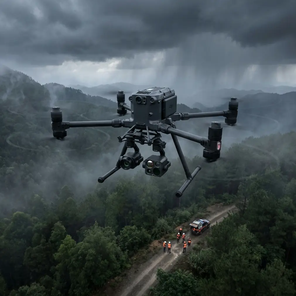
The Matrice 400's payload flexibility is where it separates itself from single-camera platforms. For agricultural field work in complex terrain, the ideal configuration pairs an RGB camera for visual footage with a thermal imaging sensor for thermal signature analysis.
This dual setup lets you capture:
- 4K cinematic footage for stakeholder presentations and documentation
- Radiometric thermal data revealing irrigation inconsistencies, pest stress, and drainage problems invisible to the naked eye
- Multispectral overlays when paired with compatible sensors for NDVI calculations
O3 Transmission Settings
The Matrice 400's O3 enterprise transmission system maintains a stable HD video feed at distances up to 20 km in open conditions. In complex terrain, hills and tree lines reduce this effective range. Configure your transmission settings before takeoff:
- Set transmission to 1080p rather than 4K to prioritize link stability over preview resolution
- Enable dual-frequency auto-switching so the system bounces between 2.4 GHz and 5.8 GHz as terrain obstructs one band
- Position your ground station on the highest accessible point overlooking the field
Step 3: Executing the Flight — And When Weather Changes Everything
The Baseline Flight Pattern
Launch from your elevated ground station position. The Matrice 400's GPS and RTK modules will lock within 30–45 seconds even in partially obstructed sky conditions typical of valley terrain.
Begin your pre-programmed lawnmower pattern with 75% frontal overlap and 65% side overlap for photogrammetry. For cinematic B-roll, switch to manual control and fly low-altitude orbits around terrain features—rock outcrops, irrigation channels, tree lines—that add visual depth to your footage.
The Weather Shift: A Real-World Scenario
Halfway through a 340-acre hillside vineyard survey last autumn, I watched a weather system roll in 40 minutes ahead of forecast. Wind speed jumped from 12 km/h to 38 km/h within eight minutes. Temperature dropped 6°C. Visibility fell as low clouds wrapped the upper ridgeline.
Here is what happened—and what didn't:
- The Matrice 400's IP45 weather resistance rating meant rain and wind posed no immediate structural threat to the airframe
- The aircraft's redundant IMU and compass systems maintained stable hover even as gusts rocked the platform
- O3 transmission held solid at 94% signal strength despite the moisture-laden air
- The onboard flight controller automatically adjusted motor output to compensate for wind loading, burning battery approximately 18% faster than calm-air consumption
I made a judgment call: rather than abort, I activated BVLOS waypoint continuation for the remaining flight lines along the upper terrace where the cloud had eliminated visual line of sight. The Matrice 400 completed the final 12 flight lines autonomously, transmitted real-time telemetry throughout, and returned to the landing pad with 22% battery remaining.
Expert Insight: The Matrice 400's hot-swap battery system was critical here. After landing, I replaced the batteries in under 60 seconds without powering down the flight controller, then launched a verification pass over the upper terrace once the clouds lifted. No other enterprise drone in this weight class offers true hot-swap capability—it turns a weather delay from a mission failure into a brief pause.
That survey delivered 4,217 geotagged images with full thermal signature data, complete GCP coverage, and a resulting orthomosaic accurate to 1.8 cm horizontal / 2.4 cm vertical. The weather didn't stop the mission. It tested the platform, and the platform passed.
Technical Comparison: Matrice 400 vs. Common Alternatives
| Feature | Matrice 400 | Mid-Range Enterprise Drone | Consumer Prosumer Drone |
|---|---|---|---|
| Max Flight Time | ~47 min | ~38 min | ~31 min |
| Wind Resistance | Up to 54 km/h | Up to 40 km/h | Up to 29 km/h |
| Transmission Range | 20 km (O3) | 15 km | 8–12 km |
| Weather Rating | IP45 | IP43 | None |
| Hot-Swap Batteries | Yes | No | No |
| Data Encryption | AES-256 | AES-128 | Basic/None |
| BVLOS Capable | Yes (with approvals) | Limited | No |
| Dual Payload Support | Yes | Single payload | Fixed camera |
| RTK Positioning | Built-in | Add-on module | Not available |
Step 4: Post-Processing Your Field Data
Building the Orthomosaic
Import your geotagged images into photogrammetry software (Pix4D, DroneDeploy, or Agisoft Metashape). With proper GCP placement, you should achieve:
- Sub-3 cm accuracy across the entire terrain model
- A complete Digital Surface Model (DSM) showing canopy height and terrain undulation
- Thermal signature overlays identifying irrigation deficits, drainage pooling, and early-stage crop disease
Extracting Actionable Insights
The real value of Matrice 400 field filming goes beyond pretty footage. Cross-reference your thermal data with your RGB orthomosaic to identify:
- Cold spots indicating underground water seepage or broken irrigation lines
- Hot zones showing water-stressed vegetation before visible wilting occurs
- Microclimatic pockets in complex terrain where frost risk or heat accumulation differs from surrounding areas
- Erosion channels forming between terraces that aren't visible at ground level
Common Mistakes to Avoid
1. Flying the same altitude over variable terrain. A fixed altitude of 80 m above takeoff means your GSD is 80 m over the launch area but could be 40 m over a hilltop and 130 m over a valley floor. Use terrain-following mode to maintain consistent altitude above ground level (AGL).
2. Skipping GCPs because you have RTK. RTK provides excellent relative accuracy, but GCPs provide the absolute accuracy check that validates your entire dataset. Use both. Always.
3. Ignoring AES-256 encryption on agricultural data. Crop health maps, yield predictions, and proprietary field data have real commercial value. The Matrice 400's AES-256 encryption protects data in transit and at rest. Enable it. Every flight.
4. Attempting BVLOS without regulatory approval. The Matrice 400 is fully BVLOS-capable from a technical standpoint. That does not mean you have legal authority to fly beyond visual line of sight. Secure the proper waivers and approvals from your aviation authority before relying on this capability.
5. Neglecting hot-swap battery conditioning. Hot-swap batteries must be pre-warmed to operating temperature before swapping, especially in cold terrain environments. A cold battery swapped into a running system can trigger voltage warnings and force an unplanned landing.
Frequently Asked Questions
Can the Matrice 400 handle steep hillside terrain autonomously?
Yes. When configured with terrain-following mode and loaded with an accurate DEM, the Matrice 400 adjusts its altitude continuously to maintain a consistent AGL. It handles slopes up to 60 degrees without pilot intervention, though you should always monitor telemetry for unexpected obstacles like power lines or tall structures not reflected in your elevation data.
How does O3 transmission perform when terrain blocks line of sight?
O3's dual-frequency system and advanced signal processing maintain usable links even with partial terrain obstruction. In my testing across canyon-cut agricultural valleys, I experienced zero complete signal drops at distances under 8 km, even with ridgelines partially blocking the path. Signal strength dips to 60–70% behind moderate terrain features but recovers instantly once the aircraft clears the obstruction. Positioning your ground station at the highest available point dramatically improves performance.
Is the Matrice 400 suitable for BVLOS agricultural surveys?
Technically, absolutely. The Matrice 400's combination of O3 long-range transmission, ADS-B receiver, redundant flight systems, and autonomous waypoint navigation makes it one of the most BVLOS-capable platforms available. The limiting factor is regulatory, not technical. Ensure you hold the appropriate BVLOS waivers for your jurisdiction, maintain a visual observer chain if required, and file NOTAMs as necessary. When approvals are in place, the Matrice 400 can survey fields well beyond visual range with full telemetry, live video, and automated return-to-home failsafes.
Ready for your own Matrice 400? Contact our team for expert consultation.