Matrice 400 for Mountain Field Filming: A Practical
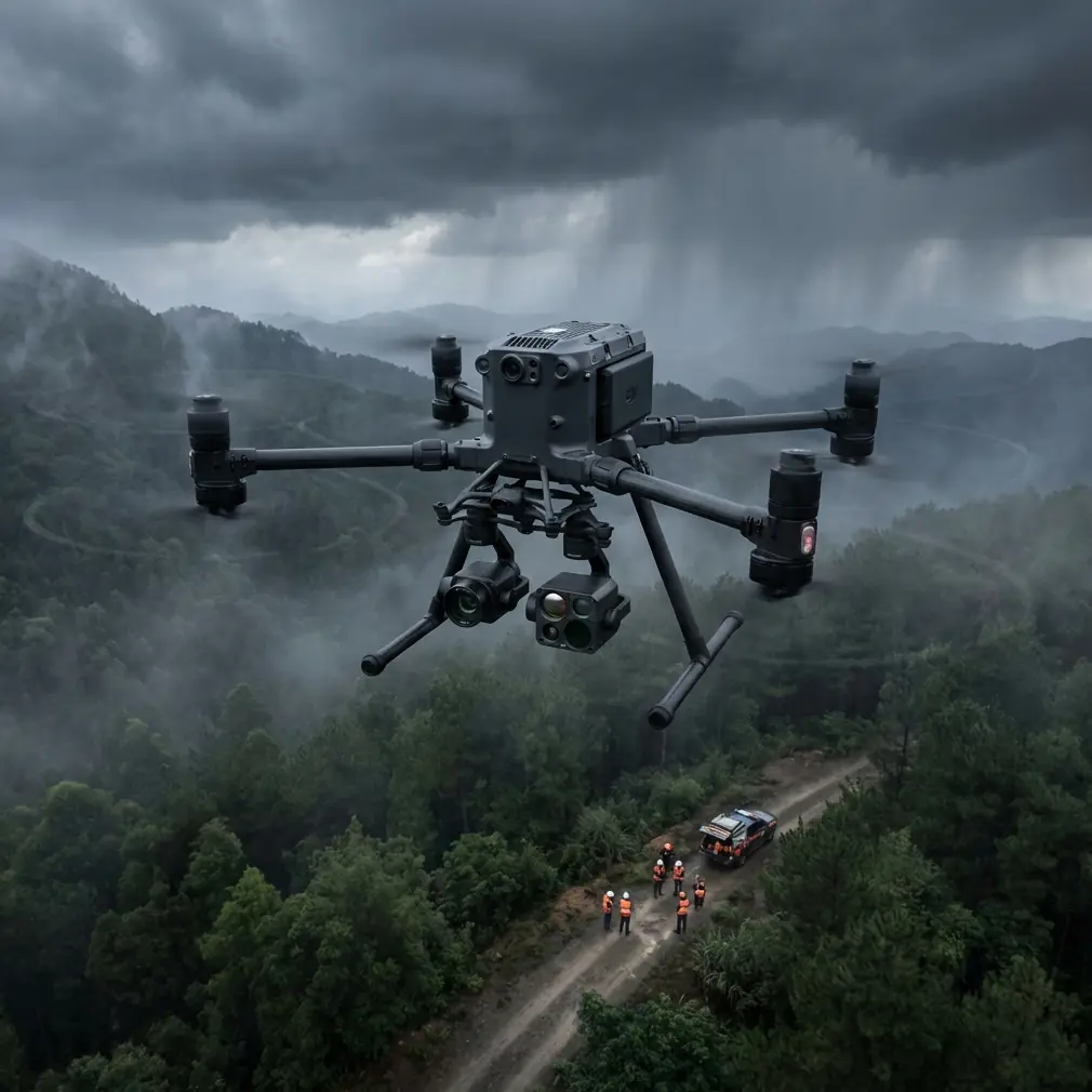
Matrice 400 for Mountain Field Filming: A Practical Workflow That Actually Holds Up
META: Expert how-to on using the Matrice 400 for filming fields in mountain terrain, covering transmission stability, thermal use, photogrammetry, GCP strategy, battery swaps, and secure operations.
Mountain field work exposes every weak point in an aircraft and every shortcut in a flight plan. Wind rolls over ridgelines in ugly bursts. Light changes by the minute. Signal paths that look clean on a map can collapse behind a shoulder of rock. If your goal is to film agricultural land spread across steep terrain, you are not just chasing pretty footage. You are trying to capture usable visual data, maintain a safe link, and get home without wasting a narrow weather window.
That is where the Matrice 400 becomes interesting.
Not because it magically removes the mountain from the equation. It does not. What it does is reduce the operational friction that usually turns mountain filming into a sequence of compromises. For crews filming fields in upland valleys, terraced slopes, or fragmented plots above road level, that matters more than headline specs.
I learned this the hard way on a mountain assignment a few seasons ago. The brief sounded simple: document crop health and irrigation patterns across a set of steep fields cut into a hillside. We needed cinematic passes for the client, but we also needed map-grade imagery the agronomy team could review later. The aircraft we had at the time could do one job well enough, but not both in the same session. Battery changes broke the rhythm. Signal confidence disappeared whenever we slipped behind terrain. We spent too much time repositioning the ground team just to keep a stable control link.
The Matrice 400 changes that workflow in a very practical way. If you are planning to film fields in mountain terrain, here is how to use it properly and why its specific capabilities matter on the ground.
Start with the mountain, not the drone
The biggest mistake in mountain filming is treating the site like a flat agricultural block with extra elevation. It is not. A mountain field introduces three separate operational problems:
- uneven line of sight between the aircraft and pilot,
- shifting microclimates across short distances,
- major differences in field orientation, which affect light, thermal contrast, and wind.
Before the Matrice 400 ever leaves the case, break the mission into zones rather than one continuous flight area. On a mountain, one ridge-facing plot may be calm and evenly lit while the next terrace is turbulent and still carrying cold moisture in the soil. That affects both your footage and your sensor results.
This is where a robust transmission system matters more than many crews admit. With O3 transmission in play, the Matrice 400 is better suited to complicated terrain because signal resilience becomes part of the mission design rather than a point of anxiety. In mountain work, that means you can stage from a smarter location instead of constantly choosing launch points based only on fear of signal loss. Operationally, that saves time and reduces rushed relocations, which are often when crews make mistakes.
It also changes how you think about shot sequencing. Instead of flying every clip opportunistically, you can structure the mission: mapping passes first while light is consistent, then lower cinematic runs once the coverage objective is complete.
Use photogrammetry first, cinematic footage second
If the assignment involves fields in mountain terrain, the smartest approach is usually to treat the flight as a data mission with a film layer on top.
The Matrice 400 is well suited for this because it can support a disciplined photogrammetry workflow without forcing you to abandon the visual side of the job. In practice, that means your first sorties should prioritize repeatable overlap, altitude consistency relative to terrain, and clean geometry for reconstruction. Once that base dataset is captured, you can shift into lower-altitude hero passes, contour reveals, and tracking shots along terraces or irrigation lines.
Why this order? Because mountain light collapses faster than people expect. A cloud bank moving across a ridge can wipe out surface consistency in minutes. Photogrammetry is much less forgiving of changing shadows than cinematic footage. Capture the reconstructable data first while your conditions are stable.
Ground control points, or GCPs, become especially important here. On a mountain field, elevation changes and sloped surfaces can amplify small positional errors in your output. A crew working without well-placed GCPs may still produce a map that looks fine at a glance, but line up that output against irrigation infrastructure or access roads and the drift becomes obvious. Good GCP placement anchors your model to the site you actually flew, not the site your software guessed.
The operational significance is simple: if the farmer, surveyor, or project manager wants to compare drainage changes over time, your dataset needs spatial discipline. A pretty mountain flight with weak control is just an expensive memory.
Thermal signature is not just for search work
Many operators hear “thermal” and think emergency response first. That misses its value for mountain agriculture and land filming.
Thermal signature matters in the mountains because terrain exaggerates differences in moisture retention, sun exposure, and plant stress. A terrace that looks evenly green in visible light may show a very different pattern once you view relative heat behavior. Early morning can be especially useful, when overnight cooling still separates wetter from drier ground and reveals inconsistencies hidden later in the day.
With the Matrice 400, thermal capability becomes more than a secondary option. It can be integrated into the mission logic. For example, after your photogrammetry grid, you can run a targeted thermal pass over suspect zones: slope breaks, drainage channels, edges of retaining walls, and shaded plots that tend to lag in drying. That gives the client something more actionable than broad scenic coverage.
Operationally, this matters because mountain fields often present false visual signals. A patch of crop can look stressed due to angle and shadow while actually being healthy. Another area can appear uniform while carrying a real moisture or irrigation issue. Thermal data helps sort appearance from condition.
That is also why I would not leave thermal flights for the end of the day by default. In mountain terrain, timing governs thermal usefulness. Plan the thermal window as carefully as you plan your golden-hour footage.
Hot-swap batteries are a bigger advantage in the mountains than on flat ground
Battery management is always important, but mountain work punishes inefficient battery changes.
A flat-field operation can often land, swap, and relaunch with minimal disruption. In the mountains, the launch area may be cramped, dusty, sloped, or exposed to gusts. You may have only one truly safe staging position. If battery changes are slow or awkward, the aircraft spends more time on the ground while the light shifts and the wind evolves.
Hot-swap batteries on the Matrice 400 directly improve that problem. The obvious benefit is reduced downtime. The less obvious benefit is continuity. When you are mid-mission and conditions are finally lining up across several hillside plots, preserving momentum is not a luxury. It is part of mission success.
From an operational perspective, this also helps you maintain cleaner datasets. Long interruptions can create mismatched lighting across image sets, forcing you to split outputs or accept visible inconsistency in orthomosaic generation. A faster battery transition helps preserve environmental continuity, which is often just as valuable as the additional airtime itself.
On mountain shoots, I also recommend assigning one crew member to battery state discipline only. Not camera settings. Not observer duties. Batteries. Temperature, charge order, swap readiness, and post-flight cooling should be handled methodically. The Matrice 400 gives you an advantage here, but only if your crew uses it with the same level of discipline.
BVLOS thinking improves even when you remain within the rules of visual operation
BVLOS is often discussed as if it only matters when the mission is formally beyond visual line of sight. In reality, BVLOS thinking is useful for any mountain operation because it forces you to plan for indirect aircraft awareness, communication resilience, and contingency routing.
A mountain field can create moments that are technically within visual range but operationally degraded. Haze, backlight, terrain masking, and complex relief can all reduce the quality of visual observation without triggering the dramatic feeling of “lost contact.” That is why the Matrice 400’s system architecture and reliable link behavior have practical value even for missions that remain fully compliant with local visual requirements.
The right question is not “Can I still see the drone?” The right question is “If the aircraft rounds that shoulder of land, do I still have enough positional confidence, signal stability, and route clarity to keep the mission safe and productive?”
Build every mountain mission as if small pockets of temporary uncertainty are likely. Predefine return lanes. Identify terrain features that can mask signal. Mark the safest abort direction for each field zone. The Matrice 400 supports that level of planning well because it is designed for serious operational use, not casual improvisation.
Security matters when land data is sensitive
Agricultural flights in mountain regions are not always casual content jobs. They can involve proprietary planting strategies, land development planning, watershed monitoring, or documentation tied to disputes and insurance. In those cases, transmission and data protection are not background details.
AES-256 matters because it strengthens the security posture of the operation, particularly when teams are moving data from aircraft to controller to downstream processing environments. For many field operators, security only becomes a priority after a client asks hard questions. Better to be ready from the start.
The operational significance is straightforward: if you are filming and mapping land that carries commercial sensitivity, your platform should not be the weakest link in the information chain. The Matrice 400 is a stronger fit for that kind of work because it supports professional-grade handling of mission data rather than treating security as an afterthought.
A mountain filming workflow that works
If I were deploying the Matrice 400 for this exact scenario today, I would run the mission like this:
First, arrive early enough to watch the ridge behavior, not just the sky above the launch point. Mountain wind often announces itself on upper vegetation before it hits your takeoff zone. Use that time to confirm where the turbulence is actually forming.
Second, place GCPs where they strengthen the model across elevation transitions, not just where they are easy to access. In steep terrain, convenience is a poor guide for control placement.
Third, fly the photogrammetry mission while light is still coherent across the fields. Keep your overlap disciplined and your route aligned with terrain logic rather than forcing a flat-land pattern onto a sloped site.
Fourth, run targeted thermal passes on the sections where moisture, runoff, or plant stress are most likely to hide. Slope changes, shaded bands, and retaining edges are usually worth a closer look.
Fifth, use the remaining battery cycles for story-driven footage: lateral reveals along terrace lines, elevated pullbacks to show field geometry against the mountain, and lower passes that explain access routes, irrigation, or land fragmentation.
And sixth, debrief before leaving the site. On mountain work, the notes you record immediately after the mission are often more valuable than the notes you try to reconstruct later. Wind behavior, signal confidence, thermal timing, and observed shadow shifts will all improve your next operation.
If you are building a field workflow around the Matrice 400 and want to compare mission planning ideas with another operator, this is a useful place to start: message our UAV team directly.
What makes the Matrice 400 especially useful here
The Matrice 400 is not just a larger platform for bigger jobs. In mountain field filming, its advantage comes from how several capabilities reinforce each other.
O3 transmission supports stronger link confidence in broken terrain. Hot-swap batteries help preserve timing and continuity when conditions are unstable. Thermal capability adds a second layer of field interpretation beyond what the eye sees. AES-256 addresses a real concern for commercial land documentation. And a platform built with serious operational planning in mind naturally fits missions where terrain complicates every decision.
That combination matters because mountain filming is rarely one thing. It is usually part survey, part inspection, part storytelling, and part risk management. Aircraft that handle only one of those demands well tend to create inefficiency everywhere else.
The Matrice 400 makes the job easier not by turning mountain work into easy work, but by allowing one properly planned mission to do the work that used to require multiple compromises.
That is the difference crews notice after a long day on a slope. Less repositioning. Fewer broken sequences. Better continuity between visual outputs and technical outputs. More confidence when the site stops behaving like the map.
For readers focused on filming fields in mountain terrain, that is the real story.
Ready for your own Matrice 400? Contact our team for expert consultation.