Matrice 400 for Low-Light Field Filming: What Actually
Matrice 400 for Low-Light Field Filming: What Actually Matters When the Weather Turns
META: Expert take on using the Matrice 400 for low-light field filming, with real operational insight on transmission stability, hot-swap batteries, thermal workflows, weather shifts, and field-ready mission planning.
Low-light field filming sounds simple until you are standing at the edge of a wet soybean block with a clock ticking against daylight, wind building from the tree line, and a client who needs usable data, not cinematic excuses.
That is where the Matrice 400 becomes interesting.
Not because it is a headline machine. Because it solves a very specific class of field problems that smaller aircraft often struggle with: carrying serious sensors, holding a stable link across broad agricultural acreage, and staying productive when conditions shift halfway through the job. If your work involves filming fields in weak light for crop assessment, thermal review, drainage checks, or visual documentation tied to mapping outputs, the aircraft matters less as a brand symbol and more as a platform that keeps the mission intact.
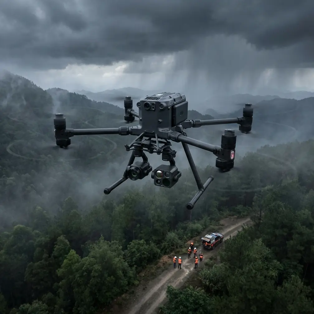
I have seen this firsthand on farmland where the original plan was straightforward: collect low-altitude visual footage of emerging stress patterns before sunrise, then capture thermal passes once the temperature contrast settled into that useful pre-dawn window. The complication arrived fast. Mid-flight, a light fog edge pushed in from the irrigation channel, wind speed jumped, and the color scene that looked manageable at takeoff became flat and murky in less than ten minutes.
That kind of change is exactly where a heavier, enterprise-built airframe earns its keep.
The real problem with filming fields in low light
Most people think low-light drone work is mainly a camera issue. It is not. The camera is only one part of the chain.
The real problem is compounded uncertainty:
- reduced visual contrast over repetitive terrain
- less margin for manual corrections
- harder obstacle perception near treelines, poles, and irrigation hardware
- faster weather deterioration than the eye expects
- increased pressure on transmission reliability when flying long rows or broad parcels
- mission interruptions when battery changes break continuity
Fields are deceptively difficult environments. They often look open, but that openness creates its own problems. Repetitive textures make orientation harder. Dew, standing water, and damp soil can soften visual detail. If you are documenting crop emergence, drainage patterns, lodging, or night-to-morning thermal transition, you need a platform that can do more than hover and record.
You need one that can carry the right payload mix, preserve control confidence at distance, and avoid wasting your best lighting window during battery swaps and setup delays.
Why the Matrice 400 fits this mission profile
The Matrice 400 makes sense for low-light field filming because it sits in the category of aircraft built for industrial continuity. That matters more than top-line specs on a brochure.
A field mission often blends several jobs into one sortie. You may start with RGB footage for client-facing visuals, then switch to thermal signature review to spot irrigation inconsistency, saturated ground, or heat retention differences across plant stands. You may also need to collect overlapping imagery suitable for photogrammetry, especially if the client wants a stitched orthomosaic or terrain model afterward.
This is where payload flexibility and operational endurance become practical advantages rather than abstract features.
For a farming client, “usable” usually means one flight can support several decisions:
- visual condition review
- thermal interpretation
- follow-up mapping
- repeatable comparison with previous passes
- documented georeferenced evidence for agronomy teams or land managers
The Matrice 400 is the kind of aircraft readers look at when they need that all-in-one mission logic.
When the weather changed mid-flight
Here is the situation that tends to separate a consumer workflow from an enterprise one.
We had launched in dim predawn light to film a series of fields with known drainage issues. The initial objective was visual footage along the low sections where compaction had been suspected. A thermal payload was part of the mission because cooler retained moisture and uneven warming can reveal field conditions that standard visible footage misses.
About one-third into the run, the weather shifted. Wind moved in crosswise. Visibility dropped slightly as moisture built in the air. The color footage immediately lost clarity at distance, and contrast over the crop rows became much harder to read.
At that point, three things mattered.
First, transmission confidence. Long agricultural parcels tempt operators to stretch farther than they should on weaker platforms. Strong O3 transmission is not just a convenience here. It is what allows the operator to maintain stable video and control confidence while repositioning over broad acreage where line-of-sight conditions can subtly degrade due to terrain undulation, shelterbelts, and moisture in the air. In low-light work, a stable link matters more because you are already operating with less visual richness in the scene.
Second, sensor strategy. Instead of forcing mediocre visible footage, we shifted the priority toward thermal signature collection in the lower zones of the field. That changed the mission from “capture pretty visuals” to “preserve diagnostic value.” This is exactly how professional drone work should function. You do not stubbornly cling to the first plan. You adapt the payload workflow to the conditions.
Third, battery continuity. On a time-sensitive mission, hot-swap batteries are not a luxury. They preserve momentum. If you are trying to maintain light consistency across adjacent blocks or finish thermal passes before sunrise changes the temperature profile too much, a long interruption can ruin comparability. Hot-swap capability reduces that downtime and keeps the flight sequence coherent.
That is one of those details operators appreciate immediately in the field. It is not glamorous, but operationally it is huge.
Thermal is not a backup. In fields, it is often the main story
The phrase “thermal signature” gets thrown around too casually. In agriculture and land inspection, thermal imaging is not there to add visual drama. It is often the fastest way to reveal conditions that ordinary footage hides.
In low light, thermal can expose:
- irrigation irregularities
- wet versus dry zones
- standing water after weather events
- uneven plant vigor patterns
- heat differences around equipment or infrastructure on agricultural sites
For field filming, the significance is straightforward. When visible light is limited, thermal does not care whether your scene looks cinematic. It cares about temperature contrast. If weather starts compromising the RGB mission, thermal may become the more valuable dataset.
The Matrice 400 earns its place in this scenario because it supports workflows that are not purely visual. That lets operators keep producing useful outputs when the environment becomes less cooperative.
Low-light filming and photogrammetry can work together
Another mistake I see is treating filming and mapping as separate worlds. On real agricultural jobs, clients often want both.
You may be asked for smooth low-angle footage of field conditions for a grower presentation, but the same site visit can also support photogrammetry if planned correctly. If the aircraft can maintain stable flight lines and your image capture parameters are disciplined, you can collect overlap for a map product while still delivering narrative footage.
That becomes more credible when tied to GCPs, or ground control points. GCP deployment is one of the most overlooked steps in agricultural mapping quality. If drainage, erosion, or planting inconsistency is being documented for future comparison, control points improve positional trust. Without them, a map may still be visually useful, but less defensible for repeat analysis.
Operationally, this means the Matrice 400 is not only about getting through bad light. It is about making one field visit count harder.
You can film the field edge, collect thermal passes over the suspected low spots, and run a photogrammetry capture pattern tied to GCPs for later analysis. That is a stronger workflow than making multiple trips with mismatched equipment and inconsistent weather windows.
Transmission and security matter more than people admit
Farm operations increasingly involve sensitive data, even when the mission looks simple from the outside. Crop performance, irrigation patterns, land condition, and infrastructure placement can all be commercially sensitive. If you are transmitting video and storing mission data, security should not be an afterthought.
That is why AES-256 support deserves mention. Not because encryption sounds impressive, but because enterprise users need confidence that field data handling is aligned with professional standards. If you are working for large growers, agronomy groups, research operations, or commercial land managers, secure transmission and storage practices help protect operational information.
Combined with O3 transmission, the significance is practical: you get both signal robustness and a higher-trust data environment. One keeps the aircraft connected. The other helps keep the mission professional.
What BVLOS changes in large agricultural operations
BVLOS is often discussed in abstract regulatory terms, but in agriculture its operational significance is easy to understand. Large properties create distance fast. Long irrigation corridors, broad row-crop blocks, and distributed infrastructure can push conventional visual workflows into inefficient stop-start patterns.
A platform associated with BVLOS-ready thinking changes how operators plan. Even when a specific mission is conducted within standard visual constraints, the aircraft’s architecture and communications ecosystem still benefit large-area work. Better situational awareness, stronger transmission, and serious mission planning tools support safer and more productive field coverage.
For growers and contractors, that translates into fewer broken survey patterns and less wasted repositioning.
How I would set up a Matrice 400 mission for low-light fields
If the job is filming fields in weak morning or evening light, I would structure the mission in layers:
1. Define the primary output before takeoff
Is the client trying to identify stress, document conditions, inspect drainage, or create footage for reporting? If the answer is “all of the above,” rank them anyway. Weather rarely lets you complete everything equally well.
2. Use thermal early if contrast favors it
Predawn and just after sunset can be prime times for thermal signature work, especially when moisture variation or heat retention differences are relevant.
3. Capture RGB footage while the scene still has enough texture
Even in low light, there is usually a short window where visible footage is still interpretable. Prioritize the segments that need the best visual storytelling first.
4. Build for continuity
Hot-swap batteries are vital here. Keep the mission moving so your footage and thermal data are captured under comparable light and weather conditions.
5. If mapping is part of the job, prepare GCPs in advance
Do not try to improvise precision. If photogrammetry matters, establish control before launch.
6. Plan for weather drift, not just weather at launch
The most common field mistake is evaluating conditions only at takeoff. Low-light windows are dynamic. Fog, dew, crosswind, and visibility shifts can force a mid-mission reprioritization.
The human side of enterprise drone work
There is a myth that better drone operations are all about automation. They are not. Better operations come from pairing a capable platform with disciplined decisions under changing conditions.
That is what stood out to me on that weather-shifted field mission. The Matrice 400 did not magically solve every problem. It gave us options when the first plan started to weaken. We could maintain a reliable link, pivot toward thermal data, keep battery downtime minimal, and preserve the value of the sortie even as conditions degraded.
That is the difference between finishing with excuses and finishing with deliverables.
If you are trying to sort out the right payload configuration or field workflow for this kind of job, you can start the conversation here via direct WhatsApp field planning support.
Who should seriously consider this platform for field filming
The Matrice 400 makes the most sense for operators and organizations that view low-light field work as a data mission, not just a video mission.
That includes:
- agricultural service providers
- crop monitoring teams
- drainage and irrigation consultants
- large farm managers
- environmental survey crews
- mapping professionals who also need inspection-grade imagery
If your work regularly involves weak light, long field edges, mixed payload requirements, or weather that refuses to stay still, this class of aircraft is not overkill. It is often the point where field reliability starts to improve in a measurable way.
The strongest reason to use a Matrice 400 for filming fields in low light is simple: it lets you salvage value when the mission stops being ideal. O3 transmission supports control and visibility across broad parcels. Hot-swap batteries protect continuity. Thermal workflows keep producing insight when RGB footage begins to flatten. AES-256 supports a more professional data posture. And if photogrammetry with GCP-backed accuracy is part of the assignment, one well-planned operation can serve several outcomes at once.
That is what clients remember. Not the drone model by itself. The fact that the work still held together when the weather did not.
Ready for your own Matrice 400? Contact our team for expert consultation.