Filming Urban Power Lines With the Matrice 400
Filming Urban Power Lines With the Matrice 400: A Practical Field Workflow
META: Expert how-to guide for filming urban power lines with the Matrice 400, covering thermal sensing, O3 transmission, AES-256 security, hot-swap batteries, GCP planning, and BVLOS-ready workflows.
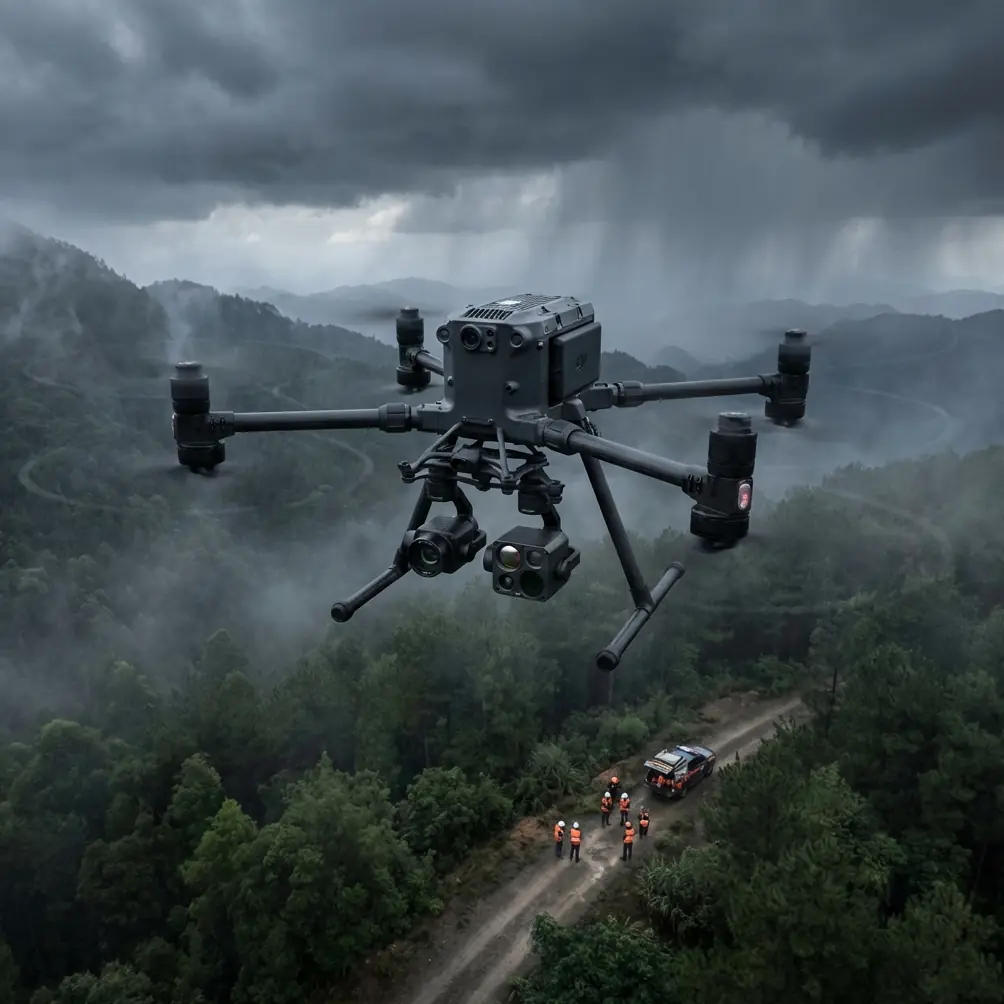
Urban power-line filming is one of those jobs that looks straightforward until you are on site. Then the variables stack up fast: reflective glass, narrow flight corridors, RF noise, traffic, birds, line sag, wind tunneling between buildings, and a client who wants footage that is both cinematic and technically useful. That is where the Matrice 400 starts to make sense—not as a flashy upgrade, but as a working platform built for dense, high-consequence environments.
If your assignment is to document power infrastructure in a city, the aircraft matters less than the workflow you build around it. The Matrice 400 fits this kind of work because it supports long-duration inspection logic rather than quick aerial passes. In practice, that means stable transmission, sensor flexibility, encrypted data handling, and battery strategy that does not force unnecessary landings in the middle of a carefully managed corridor.
This guide walks through how I would approach filming urban power lines with a Matrice 400, with special attention to thermal signature capture, repeatable photogrammetry, security, and operational continuity.
Start with the mission, not the shot list
Power-line filming in a city usually serves more than one audience. Utilities may want conductor condition, attachment hardware visibility, vegetation proximity, pole-top component records, or thermally suspicious areas. Communications teams may want cleaner hero footage for public reporting or contractor documentation. Engineers might want frame-accurate imagery that can be cross-referenced with maps and prior inspections.
Those are not the same outputs, so define the mission before you launch.
With the Matrice 400, I split the job into three layers:
- Safety and route intelligence
- Inspection-grade data capture
- Editorial or presentation footage
That sequencing is deliberate. If you start by chasing pretty orbits around infrastructure, you increase risk and often miss the repeatable, measurable material the client actually needs.
In urban work, the first useful deliverable is usually not a video clip. It is a reliable corridor record.
Build a corridor plan around transmission reality
Cities punish weak links. Not always with a total signal loss, but with intermittent degradation that is much worse because it tempts pilots to keep going. Concrete canyons, rooftop interference, cellular density, and unpredictable line-of-sight changes all work against a clean command path.
This is why O3 transmission is operationally significant for the Matrice 400 in urban power-line work. It is not just about range on a spec sheet. It is about keeping a stable video and control link when the aircraft moves behind street furniture, near mid-rise obstructions, or across intersections where multipath interference gets ugly. A more resilient transmission system lets the crew hold a safer standoff distance instead of creeping too close to the conductors just to preserve visual confidence.
For city corridor jobs, I recommend dividing the route into short controlled segments rather than one long continuous run. Even if the aircraft can go farther, segmenting the mission gives you cleaner file organization, easier observer positioning, and tighter contingency planning.
A practical segment might be:
- one block face
- one substation perimeter edge
- one transition between poles and rooftop feeds
- one crossing over a rail or roadway corridor
That structure also helps if your operation later expands into a BVLOS framework. Even when you are not flying true beyond visual line of sight under approval, planning as though the route must survive disciplined handoffs improves everything: observer spacing, comms, emergency procedures, and data continuity.
Use thermal deliberately, not decoratively
Thermal is one of the most misused tools in utility filming. Operators often switch it on, grab a few dramatic frames, and call it added value. That is not inspection. It is just warm-colored video.
If you are using the Matrice 400 to document a thermal signature along urban power lines, define what abnormality you are trying to isolate. Are you checking connectors, insulators, transformer housings, splices, or load-related hotspots? The answer changes your altitude, angle, time of day, and pacing.
In a city, reflective surfaces and mixed heat sources complicate thermal interpretation. Rooftop HVAC systems, sun-loaded parapets, vehicle exhaust, and even recently heated building materials can create false visual priority. The key is to capture thermal data from angles that preserve infrastructure context. Do not let the thermal view float in isolation. Pair it with visible-spectrum framing that shows exact component position relative to the pole, crossarm, building edge, or feeder route.
The Matrice 400 is well suited to this because it can be part of a sensor-led workflow rather than a single-camera workflow. For utilities, that matters. A hotspot means more when you can immediately verify what component you are looking at and where it sits in the urban network.
One field tactic I rely on: make two passes when conditions allow. The first is a slower, context-rich thermal sweep. The second is a tighter visual pass to confirm hardware identity and surrounding clearance. That combination saves time later when the engineering team reviews the footage.
Plan for photogrammetry even if the client asked for video
This is a common mistake. A client says they need video of urban power lines, so the crew flies only cinematic or inspection-style motion shots. Then three days later someone asks whether the same mission can support measurement, comparison, or 3D reconstruction.
Sometimes it can. Often it cannot, because nobody flew it with photogrammetry discipline.
If your Matrice 400 mission has any chance of feeding mapping or asset documentation, bake that into the route from the start. That means consistent overlap, stable speed, repeatable camera geometry, and documented GCP placement where ground access allows it.
GCPs are especially useful in urban utility work because city environments introduce geometric complexity—curbs, poles, building setbacks, alleys, and mixed elevation changes. A few well-surveyed control points can dramatically improve downstream alignment if the data is used for corridor modeling or infrastructure context mapping. Even when the power lines themselves are the headline subject, the surrounding urban geometry often becomes part of the engineering conversation.
The operational significance here is simple: a video-only mindset produces attractive footage; a photogrammetry-aware mindset produces footage that remains useful after the first viewing.
Protect the data like it matters
Utility infrastructure footage is not casual content. In many cases, it includes sensitive details about network layout, component access, rooftop adjacency, and right-of-way conditions. If you are flying in a city, the sensitivity only goes up.
That is why AES-256 support is more than an IT talking point in the Matrice 400 ecosystem. It matters operationally because it helps secure command, footage handling, and mission data in workflows where infrastructure imagery may pass through multiple hands—pilot, observer, asset manager, contractor, consultant, and client-side review team. Strong encryption reduces the chance that an otherwise disciplined field operation is undermined by weak data hygiene.
For urban power-line projects, I recommend a simple rule: treat every mission folder as if it contains restricted infrastructure intelligence. Label cleanly, transfer promptly, and limit uncontrolled duplication. Security is not separate from flight ops. It is part of the chain of custody.
Hot-swap batteries change how you manage risk
Battery swaps are often treated as a time issue. In urban utility work, they are really a continuity issue.
Hot-swap batteries are one of the most practical Matrice 400 advantages for this kind of assignment. If you are working a controlled corridor with police awareness, utility spotters, road management, or time-limited access to a rooftop launch site, a full shutdown between sorties can cost far more than a few minutes. It can break visual continuity, interrupt observer coordination, and force re-briefing in a cluttered environment.
A hot-swap workflow lets you keep the aircraft ready while refreshing power with less disruption. That matters when you are trying to film a line section under stable lighting or consistent traffic conditions. It also matters when you need to hold your operational rhythm after a partial capture, then resume before weather, shadows, or local activity changes the scene.
The benefit is not just endurance. It is momentum.
Wildlife is not a side issue
On one urban line inspection near a canal edge, the most difficult moment of the day had nothing to do with RF or wind. A grey heron lifted from a rooftop drainage channel and crossed into the flight path just as the aircraft was transitioning from a pole-top angle to a wider corridor move. The encounter lasted only seconds, but it was enough to prove why sensor awareness and conservative route geometry matter in city operations.
Bird behavior around urban infrastructure is inconsistent. Some species ignore the aircraft. Others appear from hidden perches with no warning. Nesting around poles, substation edges, and warm rooftop equipment is common enough that every power-line filming plan should include wildlife contingencies.
The lesson is straightforward: do not fly routes that require perfect prediction. Give yourself lateral escape room. Build pauses into the mission. Use the Matrice 400’s sensing and situational awareness capabilities as part of your route design, not just as emergency backstops.
If your crew regularly works around utilities, it helps to keep a direct field coordination channel ready for quick changes and wildlife-related holds. A simple option is to set up a briefing thread before launch using a field-ready WhatsApp check-in.
Camera movement should match inspection logic
Urban power lines do not reward flashy flying. The best footage usually comes from controlled, intentional movement that preserves engineering readability.
Three moves consistently work well with the Matrice 400 in these environments:
- Parallel tracking passes that keep conductor spacing and background context legible
- Slow oblique reveals that show attachment hardware without flattening depth
- Short vertical offsets to compare pole-top equipment against nearby building lines
Avoid aggressive arcs close to energized assets. They often create more motion drama than usable information. In cities, they also raise your exposure to lateral obstacles you cannot fully monitor while prioritizing composition.
A good rule is this: if the footage makes it harder to judge line condition, clearances, or component relationships, the move is wrong no matter how cinematic it looks.
Urban launch discipline is half the job
The Matrice 400 can support serious utility work, but the quality of the output still depends on your ground game.
For city operations, I like a launch checklist built around five questions:
- Where is the cleanest emergency landing option within 30 seconds?
- Which observer covers the next blind sector before the aircraft gets there?
- What RF interference sources are visible right now, not just expected?
- Which segment can be abandoned with no data loss if the route tightens?
- What piece of footage is mission-critical before conditions change?
That last question matters. Urban light shifts quickly. Shadows from towers and passing cloud can ruin consistency along a line corridor. If you need thermal confirmation and visual context, decide which capture comes first based on current conditions rather than the original plan on paper.
A practical Matrice 400 workflow for urban line filming
Here is a field-tested sequence I would use:
1. Pre-brief the corridor Identify line sections, rooftop hazards, traffic influence, bird activity, and observer positions.
2. Run a short reconnaissance pass Confirm actual interference, wind channels, and hidden obstructions before the main capture.
3. Capture thermal context first if heat contrast is favorable Do not wait until urban surfaces wash out the signatures you need.
4. Fly repeatable visual passes Use stable speed and geometry so the footage can support later comparison.
5. Add mapping discipline where feasible If GCPs and overlap are possible, capture with future modeling in mind.
6. Use hot-swap efficiency to preserve sequence continuity Resume the corridor without rebuilding the entire operation from scratch.
7. Secure and log data immediately Tag by segment, structure type, and sensor mode while the mission is fresh.
That is where the Matrice 400 earns its place. Not in one isolated spec, but in the way O3 transmission, AES-256 security, thermal-capable workflows, hot-swap battery logic, and corridor-ready planning combine into a platform that behaves well under urban inspection pressure.
What operators often get wrong
The most common failure is treating urban utility filming like a standard commercial drone shoot with wires in the background. It is not. The lines are the subject, the hazard, and often the reason the client hired you in the first place.
The second failure is underestimating how much future value can be pulled from one disciplined mission. If you capture thermal signature, visual confirmation, geospatial consistency, and secure metadata in a single operation, the same sortie can serve maintenance teams, planners, asset managers, and communications staff.
That is the bigger point with the Matrice 400. For urban power-line work, the platform is not interesting because it flies. Plenty of aircraft fly. It is interesting because it supports a more rigorous kind of job design.
And that is exactly what dense utility environments demand.
Ready for your own Matrice 400? Contact our team for expert consultation.