Matrice 400 in the Hills: a Field Report on Filming Power
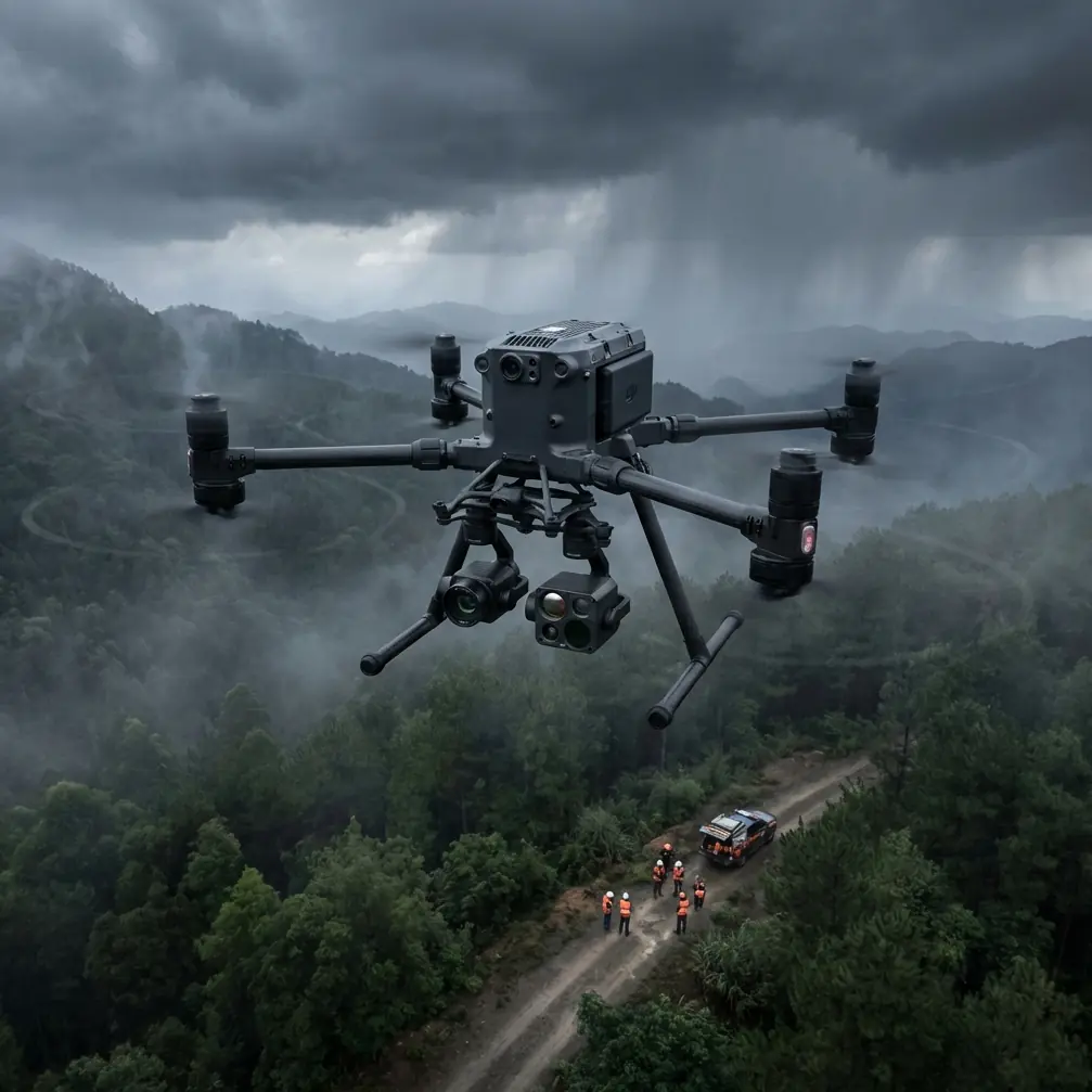
Matrice 400 in the Hills: a Field Report on Filming Power Lines Where the Airspace Fights Back
META: Expert field report on using Matrice 400 for power line filming in complex terrain, with insights on vision processing, thermal signature work, transmission reliability, and why material science still matters aloft.
By James Mitchell
Power line filming sounds straightforward until the terrain starts making decisions for you.
On paper, the brief is simple: document conductor condition, insulator strings, vegetation encroachment, tower hardware, and thermal anomalies across a corridor that snakes through ridgelines and narrow valleys. In the field, the problem changes shape every few minutes. Wind shears off one slope and drops into a hollow. Light bounces off bare rock and confuses exposure. A transmission tower sits cleanly in line of sight, but the next span disappears behind a fold in the mountain. That is where a platform like the Matrice 400 earns its reputation—not in the spec sheet, but in the moments where sensing, transmission, and operator confidence all have to hold together at once.
On one recent power line filming mission in broken terrain, the most telling moment had nothing to do with the towers. We were tracking a line section along a forested saddle when a large raptor lifted out of the treeline and crossed the corridor ahead of the aircraft. No drama, no sudden lurch. The crew adjusted spacing, held the shot envelope, and let the aircraft’s sensing package do its job while the bird cleared. That kind of encounter is a reminder that infrastructure work in remote terrain is never just about steel and cable. You’re flying in a living environment, and the best aircraft are the ones that help you stay precise without becoming brittle.
Why Matrice 400 makes sense for power line filming
For utility imaging in mountains, the aircraft has to solve four problems at the same time.
First, it needs a dependable live view for the pilot and payload operator even when the corridor bends through uneven topography. Second, it needs payload flexibility: visible imaging for structure detail, thermal signature capture for hotspot detection, and often photogrammetry passes for corridor modeling. Third, it needs workflow resilience. Long corridors punish aircraft that force frequent shutdowns or slow battery turns. Fourth, it needs to support disciplined operations for more advanced mission profiles, including BVLOS programs where regulations and risk controls allow.
That is why features like O3 transmission, AES-256 data security, and hot-swap batteries are not marketing ornaments here. In power line filming, they are operational multipliers.
O3 transmission matters because complex terrain is hostile to clean signal behavior. A ridgeline can shadow your path. Dense vegetation can alter your angle options. When a drone is working around towers and spans that stretch in and out of broken line of sight, robust transmission is not just about image quality; it affects decision speed. If the feed stutters while you are examining a clamp, spacer, or insulator cap from offset position, the inspection value drops immediately. A strong link lets the team maintain smoother camera movement, better framing discipline, and safer positioning.
AES-256 matters for a different reason. Utility clients increasingly treat infrastructure imagery as sensitive operational data. The exact location of thermal issues, damaged fittings, or vulnerable line sections is not something operators should move around casually. Strong encryption is part of professional trust. It belongs in the same category as log discipline, storage handling, and chain-of-custody habits for asset imagery.
Hot-swap batteries are the feature crews learn to appreciate after the third mountain launch site of the day. In corridor work, battery swaps are not a minor pause. They can break flight rhythm, cost weather windows, and add unnecessary resets when the crew is trying to maintain a repeatable capture sequence. The ability to keep the aircraft alive during battery changes reduces disruption and preserves setup efficiency, especially when you’re filming a line segment that needs multiple passes: visual, thermal, and oblique coverage for later modeling.
What the sensor stack really needs to see
Power line filming in difficult country is no longer just “get close and zoom in.” The useful output often includes three overlapping products:
- cinematic or documentary corridor footage for planning and reporting
- thermal signature review to identify suspect components
- photogrammetry data for mapping, vegetation analysis, and structure context
Those jobs place different demands on the aircraft and the operator. Thermal work wants stable acquisition and disciplined interpretation. Photogrammetry wants overlap, consistency, and reliable positioning, often tightened further by GCP-backed workflows where survey control is required. Narrative footage wants fluid movement and enough confidence in the aircraft to let the camera operator concentrate on composition rather than defensive flying.
What matters is not only payload quality, but how the aircraft helps the crew isolate the right subject inside a cluttered visual environment. That is where an older but still relevant research thread becomes surprisingly useful.
One of the reference materials behind this article describes a machine vision method built around an “eagle-eye” style visual model. The research uses an 8-dimensional feature vector for each pixel to estimate saliency by comparing local feature covariance. In plain language, the system tries to identify what stands out from its surroundings instead of treating every part of the image equally. The same source also describes converting RGB imagery into HSV channels and selecting the S channel when a target marker is most distinct there, followed by median filtering, threshold segmentation, and morphological cleanup.
Why should a Matrice 400 operator filming power lines care?
Because this is exactly how hard terrain punishes weak visual logic. In a mountain corridor, the target is almost never isolated. Towers merge into rock textures. Conductors cut across bright cloud edges. Damp vegetation can produce misleading thermal patterns late in the day. The practical lesson from that reference is not about copying a lab algorithm into field procedure. It is about respecting saliency. Good utility crews learn to frame and configure sensors so the asset feature that matters is the one that visually separates from the environment.
That affects how you plan your pass angle, how you choose time of day, and how you balance visible and thermal acquisition. If a clamp or connector is likely to hide in low-contrast background, your flight geometry matters as much as your payload. If a thermal anomaly is subtle, reducing visual clutter and preserving stable viewing angle becomes part of data quality. The Matrice 400’s value is that it gives the operator the confidence to fly those cleaner, more deliberate profiles.
A note on thermal signature work in rough country
Thermal inspections around power infrastructure are often misunderstood by crews who come from pure filming backgrounds. The camera does not “find problems” on its own. It records heat differences, and those differences only become meaningful when the aircraft can hold a sensible inspection view and the operator understands the context.
In complex terrain, false confidence comes easily. Sun-loaded rock faces, reflective surfaces, and uneven cooling across shaded valleys can distort the thermal story around a line. The right response is not to distrust the tool; it is to build repeatable capture discipline. Fly the line section with enough consistency that a hotspot on a connector or splice can be interpreted against surroundings rather than guessed at in isolation.
This is where the Matrice 400 platform approach helps. When transmission is stable and battery management is less disruptive, crews are more likely to complete paired passes properly instead of rushing one compromised thermal run before heading home. Better still, if the mission also supports photogrammetry, those thermal observations can be placed inside a mapped corridor model, often tied to GCP-backed control when engineering-grade positional confidence is required.
Material science still matters, even if you never touch the airframe
The second reference document looks, at first glance, far removed from drone fieldwork. It is a materials handbook page covering physical properties of copper alloys. But for anyone filming power assets, those numbers are not abstract.
The reference lists several alloys and their physical properties, including density, conductivity, and thermal expansion behavior. For example, C11000 is shown with electrical conductivity around 388 and thermal conductivity around 385, while C63000 is listed much lower in conductivity terms, around 37.3, with density about 7.58. Another detail that matters is thermal expansion: one line in the table shows C46400 reaching about 21.2 × 10^-6 per degree Celsius over the 20 to 300°C range, while C63000 is shown around 16.2 × 10^-6 over the same span.
Those are not trivia points. They help explain why different hardware in the same visual field may age, heat, and move differently under load and temperature change. When a Matrice 400 crew films terminations, connectors, bus-related components, or mixed-metal assemblies, understanding that conductive and expansion properties vary by alloy helps avoid shallow interpretation. A thermal hotspot is not just “the bright part.” A component’s material characteristics, connection quality, and loading context all influence what you are seeing.
The handbook also references treatment states for alloy strip products such as TB00 and TF00, with TF00 involving solution treatment followed by aging. That matters operationally because power hardware is manufactured, processed, and stressed in ways that affect in-service behavior over time. Drone imagery does not replace engineering analysis, but better-informed crews capture more useful evidence for the people who will make the maintenance decision.
This is one of the quiet advantages of experienced Matrice 400 operations: the best teams do not just fly well. They understand enough about the assets to know what deserves a second angle, a tighter thermal look, or a repeat pass under different light.
Workflow realities: filming, inspection, and mapping on the same day
Utility clients increasingly want one field deployment to support multiple departments. The line maintenance team wants actionable condition footage. Asset management wants consistent visual documentation. Planning may want corridor mapping. Environmental teams may want vegetation context. That means the aircraft has to transition cleanly between cinematic movement, inspection pacing, and photogrammetric discipline.
The Matrice 400 is well suited to that mixed-role day because the platform logic is practical rather than theatrical. You can move from tower-detail work into broader corridor capture without feeling like you are forcing a single-purpose aircraft into a second job. Add hot-swap battery workflow and strong transmission performance, and the crew can stay in productive rhythm rather than constantly rebuilding momentum.
For BVLOS-oriented organizations, that rhythm matters even more. The issue is not just maximum reach. It is whether the aircraft and the operating concept support a high-confidence information chain over longer, more structured missions. Utility programs that are maturing toward BVLOS need predictable command link behavior, secure data handling, and payload outputs that remain useful for engineering review. Matrice 400 fits that conversation when it is operated inside a serious compliance and risk framework.
The field lesson I keep coming back to
When crews discuss power line filming in difficult terrain, they usually talk first about weather, battery endurance, or lens choice. Those all matter. But the deeper pattern is this: success comes from reducing ambiguity.
You reduce ambiguity in control by using a platform with trustworthy transmission. You reduce ambiguity in handover and data handling with secure workflows such as AES-256. You reduce ambiguity in mission tempo with hot-swap batteries. You reduce ambiguity in image interpretation by understanding both visual saliency and the physical behavior of the materials you are looking at.
That is why the two reference threads behind this article—machine vision feature extraction and copper alloy physical properties—actually belong in the same conversation. One explains how to separate the signal from a visually cluttered environment. The other explains why the asset itself may behave differently from one component to the next. Together, they sharpen how a professional crew uses a Matrice 400 in the real world.
And that is the real story of this aircraft in complex terrain. Not that it flies. Plenty of drones fly. The point is that it helps an experienced team keep seeing clearly when the landscape, the infrastructure, and even the wildlife are all trying to complicate the job at once.
If you are building a utility filming workflow around Matrice 400 and want to compare sensor strategy, corridor planning, or payload choices, you can message the field team here.
Ready for your own Matrice 400? Contact our team for expert consultation.