Matrice 400 Guide: Filming Vineyards in Mountains
Matrice 400 Guide: Filming Vineyards in Mountains
META: Learn how to film mountain vineyards with the DJI Matrice 400. Expert tutorial covering flight planning, photogrammetry, thermal mapping, and pro tips.
Author: James Mitchell | Drone Cinematography & Precision Agriculture Specialist
TL;DR
- The Matrice 400 is purpose-built for demanding mountain vineyard operations where altitude changes, wind gusts, and complex terrain make consumer drones unreliable.
- O3 transmission ensures uninterrupted video feed across valleys and ridgelines where signal loss is a constant threat.
- Hot-swap batteries keep you airborne during long mapping sessions across sprawling hillside vineyards.
- Pairing the Matrice 400 with a third-party multispectral sensor like the MicaSense RedEdge-P unlocks vine health analytics that native payloads alone cannot deliver.
Why Mountain Vineyards Demand an Enterprise-Grade Drone
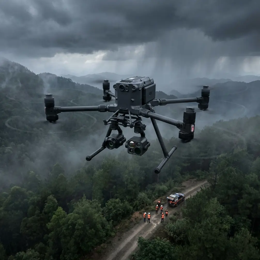
Mountain vineyard filming is not a casual flight. Steep slopes exceeding 30-degree gradients, turbulent updrafts along ridgelines, and rapidly shifting lighting conditions between sun-exposed and shaded rows create a hostile operating environment for standard prosumer drones. The Matrice 400 was designed for exactly this kind of pressure.
This tutorial walks you through every phase of a mountain vineyard filming operation—from pre-flight planning and GCP placement to thermal signature analysis and final photogrammetry deliverables. Whether you're producing cinematic footage for a winery's marketing team or generating actionable crop health maps, the workflow principles remain the same.
By the end, you'll understand how to leverage AES-256 encrypted data handling, plan BVLOS-ready missions, and integrate third-party accessories that transform the Matrice 400 from a capable aircraft into a vineyard intelligence platform.
Pre-Flight Planning for Mountain Terrain
Topographic Assessment
Before the Matrice 400 ever leaves its case, you need a detailed topographic model of the vineyard. Mountain vineyards rarely sit on a single plane. Rows follow contour lines, and elevation can shift by 200+ meters across a single property.
Use publicly available DEM (Digital Elevation Model) data to build a preliminary terrain profile. Import this into your flight planning software—DJI Pilot 2 handles terrain-follow missions natively, which is critical for maintaining consistent GSD (Ground Sample Distance) across slopes.
- Set your terrain-follow altitude to 40-50 meters AGL for photogrammetry missions
- Use 60-80 meters AGL for wide cinematic establishing shots
- Drop to 15-25 meters AGL for close-up vine row detail work
- Always add a 10-meter safety buffer above the tallest canopy or trellis structure
Ground Control Point (GCP) Placement
Accurate photogrammetry in mountain terrain demands GCPs. Without them, your orthomosaic will warp across elevation changes, rendering measurements unreliable.
Place a minimum of 5 GCPs per 10-hectare block, distributed so that at least one sits at the highest and lowest elevation points of the survey area. Use high-visibility checkered targets sized at 60cm x 60cm minimum—anything smaller becomes difficult to resolve at 40 meters AGL.
Pro Tip: In mountain vineyards, anchor your GCP targets with landscape staples rather than weights. Wind gusts channeling through valleys can exceed 40 km/h without warning, and a shifted GCP invalidates every dataset tied to it.
Flight Execution: Getting the Matrice 400 Airborne
Battery Strategy and Hot-Swap Protocol
A full mountain vineyard survey often requires 90+ minutes of flight time. The Matrice 400's hot-swap batteries are not just convenient—they're essential. Each battery set delivers approximately 45 minutes of flight under moderate wind conditions, though mountain thermals and sustained climbs can reduce this to 32-38 minutes.
Plan your mission in blocks:
- Block 1: High-altitude cinematic passes and wide photogrammetry grid
- Block 2 (after hot-swap): Low-altitude vine row detail and thermal signature capture
- Block 3 (if needed): Targeted re-flights for any gaps identified during in-field QA
Label each battery set and log cycle counts. Mountain operations stress batteries harder than flatland work due to constant altitude compensation by the motors.
O3 Transmission and Signal Management
The O3 transmission system on the Matrice 400 maintains a stable 1080p live feed at distances exceeding 15 kilometers in optimal conditions. Mountain vineyards, however, are not optimal conditions.
Ridgelines, dense canopy, and rocky outcrops create signal shadows. Position your ground station on the highest accessible point with a clear line of sight to the majority of the vineyard. If the property wraps around a hillside, you may need to relocate your ground station mid-mission.
- Keep the controller antenna oriented toward the aircraft at all times
- Monitor signal strength indicators—if RSSI drops below -85 dBm, bring the aircraft to a higher altitude before it drops behind terrain
- AES-256 encryption runs automatically, securing your live feed and stored data without any performance penalty
Expert Insight: I've flown vineyards in the Douro Valley where a single ridgeline cut my O3 signal entirely at 800 meters horizontal distance. Relocating my ground station just 50 meters uphill restored full signal. Never underestimate terrain masking—it's the number one cause of signal loss in mountain operations.
Payload Configuration: Native and Third-Party Options
The MicaSense RedEdge-P Integration
Here's where the Matrice 400 becomes a true vineyard analytics tool. The native camera systems handle cinematic footage and RGB photogrammetry brilliantly, but for vine health assessment, a third-party multispectral sensor changes everything.
The MicaSense RedEdge-P mounts cleanly to the Matrice 400's payload interface using a DJI SkyPort adapter. This sensor captures 5 discrete spectral bands simultaneously, enabling NDVI, NDRE, and chlorophyll index calculations that reveal stress patterns invisible to the naked eye.
During a recent mountain vineyard project in the Rhône Valley, the RedEdge-P identified early-stage Esca disease in 3 vine blocks that appeared perfectly healthy in RGB imagery. The thermal signature data from the Matrice 400's native thermal sensor correlated with the multispectral findings—stressed vines showed a 2.3°C temperature differential compared to healthy neighbors.
Thermal Signature Mapping
Thermal imaging in vineyards reveals irrigation inefficiencies, disease onset, and microclimate variations across slopes. The Matrice 400's thermal sensor operates at a resolution sufficient to distinguish individual vine canopies at 40 meters AGL.
For best results:
- Fly thermal missions during early morning (6:00–8:00 AM) or late afternoon before the canopy reaches thermal equilibrium
- Set radiometric calibration to the expected surface temperature range (10–45°C for most growing-season conditions)
- Overlap thermal passes at 80% forward / 70% side to ensure complete stitching
Technical Comparison: Matrice 400 vs. Common Alternatives
| Feature | Matrice 400 | Competitor A (Mid-Range Enterprise) | Competitor B (Prosumer) |
|---|---|---|---|
| Max Flight Time | ~45 min | ~35 min | ~31 min |
| Hot-Swap Batteries | Yes | No | No |
| Transmission System | O3 (15+ km range) | OcuSync 3 (12 km) | OcuSync 2 (8 km) |
| Data Encryption | AES-256 | AES-128 | None |
| BVLOS Readiness | Full compliance-ready | Partial | No |
| Third-Party Payload Support | SkyPort adapter | Limited | None |
| Terrain-Follow Accuracy | ±1 meter | ±3 meters | ±5 meters |
| IP Rating | IP55 | IP45 | None |
Post-Processing Workflow
From Raw Data to Deliverable Maps
Once you've landed, the real work begins. Transfer your datasets—RGB, thermal, and multispectral—to your processing workstation. For mountain vineyard photogrammetry, Pix4Dmatic or Agisoft Metashape handle elevation variation far better than consumer-grade stitching software.
Key processing steps:
- Import GCP coordinates and align them with target markers in your image set
- Generate a dense point cloud at full resolution—mountain terrain demands it
- Build a DSM (Digital Surface Model) before your orthomosaic to validate elevation accuracy
- Process thermal and multispectral layers separately, then overlay them in GIS software like QGIS
Expect 4-6 hours of processing time for a 20-hectare mountain vineyard at full resolution on a workstation with 64GB RAM and a modern GPU.
Pro Tip: Export your NDVI maps with vine row boundaries pre-clipped. Vineyard managers don't want to see inter-row soil data cluttering their health maps. Delivering clean, row-isolated analytics demonstrates professionalism and makes your data immediately actionable.
Common Mistakes to Avoid
Flying in midday thermals without adjusting PID settings. Mountain updrafts peak between 11:00 AM and 2:00 PM. The Matrice 400 handles wind well, but aggressive thermals cause altitude oscillation that ruins photogrammetry overlap consistency.
Neglecting GCP elevation accuracy. A GCP with precise XY coordinates but a 2-meter elevation error will distort your entire DSM on a steep slope. Use RTK-corrected GPS for all GCP surveys.
Using a single battery set for the entire mission. Hot-swap exists for a reason. Pushing a depleted battery through "just one more pass" in mountain terrain is how aircraft end up in ravines.
Ignoring AES-256 data security for client projects. Vineyard data—especially precision agriculture analytics—is proprietary. Some operators disable encryption to speed transfers. Don't. Your client's competitive intelligence is in those maps.
Skipping BVLOS regulatory checks. Mountain vineyards frequently require flying beyond visual line of sight due to terrain. Verify your local aviation authority's BVLOS waiver requirements before every project—regulations vary by region and change frequently.
Frequently Asked Questions
Can the Matrice 400 handle sustained mountain winds during vineyard surveys?
Yes. The Matrice 400 is rated for operations in wind speeds up to 12 m/s sustained, with gust resistance higher than that. Mountain valley winds typically range from 5–10 m/s during morning flight windows. The aircraft's GPS and IMU systems compensate for gusts in real time, maintaining position accuracy within ±0.1 meters horizontally. That said, always check localized wind forecasts for the specific ridgeline you're operating near—microclimate gusts can exceed regional forecasts significantly.
How does the MicaSense RedEdge-P integrate with the Matrice 400?
The RedEdge-P connects via DJI's SkyPort adapter, which provides both power and data communication between the sensor and the flight controller. Once mounted, the sensor triggers automatically based on your flight plan's waypoint intervals. Calibration requires a reflectance panel image captured before and after each flight. The entire integration adds approximately 350 grams to the aircraft's payload, which reduces flight time by roughly 3-5 minutes per battery set.
Is BVLOS flight legal for vineyard mapping with the Matrice 400?
BVLOS legality depends entirely on your jurisdiction. In the EU, operations under the Specific Category with a SORA (Specific Operations Risk Assessment) can authorize BVLOS flights. In the US, a Part 107 waiver is required. The Matrice 400 is equipped with the sensors, redundancy systems, and ADS-B awareness features that regulators typically require for BVLOS approval, making the waiver application process significantly more straightforward than with less-equipped platforms.
Ready for your own Matrice 400? Contact our team for expert consultation.