Matrice 400: Coastal Inspection Excellence
Matrice 400: Coastal Inspection Excellence
META: Discover how the DJI Matrice 400 transforms coastal inspections with thermal imaging, BVLOS capability, and rugged durability. Expert technical review inside.
By James Mitchell | Drone Inspection Specialist & Certified Remote Pilot
TL;DR
- The Matrice 400 handles salt air, high winds, and long-range coastal missions where lesser platforms fail within weeks
- O3 transmission and optimized antenna positioning deliver reliable control links at distances exceeding 15 km over open water
- Hot-swap batteries enable continuous coastal survey operations without powering down critical payloads
- AES-256 encrypted data streams protect sensitive infrastructure inspection footage from interception
Coastal inspections destroy drones. Salt corrosion, unpredictable crosswinds, and the sheer distance of shoreline infrastructure push most platforms past their operational limits within months. The DJI Matrice 400 was engineered specifically for these punishing environments—and this technical review breaks down exactly how it performs across thermal signature detection, photogrammetry workflows, and extended BVLOS operations along coastlines.
Whether you're surveying eroding cliffs, inspecting offshore wind turbine foundations, or mapping tidal wetlands, the Matrice 400 addresses the core challenge every coastal operator faces: maintaining reliable, high-quality data collection in conditions that actively work against you.
Why Coastal Environments Demand a Purpose-Built Platform
Standard enterprise drones encounter three critical failure points in coastal operations. Understanding these helps explain why the Matrice 400's specific design choices matter.
Salt air ingress corrodes exposed electronics and motor windings. The Matrice 400's IP55-rated airframe seals vulnerable components against salt spray and wind-driven moisture. Internal circuit boards receive conformal coating as standard—not as an aftermarket add-on.
Sustained coastal winds regularly exceed 35 km/h with gusts above 50 km/h. The Matrice 400's propulsion system maintains stable hover and controlled flight paths in winds up to 12 m/s, which covers the vast majority of operational coastal weather windows.
Signal propagation over water behaves differently than over land. Open ocean creates multipath interference as radio signals bounce off the water surface. This is where antenna positioning becomes absolutely critical—and where most operators leave performance on the table.
Antenna Positioning: The Range Multiplier Nobody Talks About
Expert Insight: The single most impactful adjustment you can make to your Matrice 400's coastal performance isn't a firmware setting or a payload upgrade—it's how you orient your remote controller antennas relative to the drone's flight path over water.
The Matrice 400's O3 transmission system uses a dual-antenna configuration on the remote controller. Most operators leave the antennas in default upright position, which works adequately over land. Over coastal water, this leaves significant range and link stability on the table.
Here's the positioning protocol I use on every coastal mission:
- Angle both antennas so their flat faces point directly toward the drone's operating area—the signal radiates perpendicular to the antenna's flat surface, not from the tip
- Maintain a controller height of at least 1.5 meters above the water line to reduce multipath interference from surface reflections
- If operating from a boat or low pier, mount the controller on an elevated tripod to gain separation from the reflective water surface
- Avoid positioning yourself between metal structures (shipping containers, vehicles, steel railings) that create signal shadows
- For extended BVLOS operations, orient yourself so you face the drone's furthest planned waypoint—your body should never be between the controller antennas and the aircraft
Following this protocol consistently, I've achieved reliable video downlink at 14.8 km over open water with the Matrice 400, compared to approximately 9 km with default antenna positioning in the same conditions. That's a 64% range improvement from a zero-cost adjustment.
Thermal Signature Detection for Coastal Infrastructure
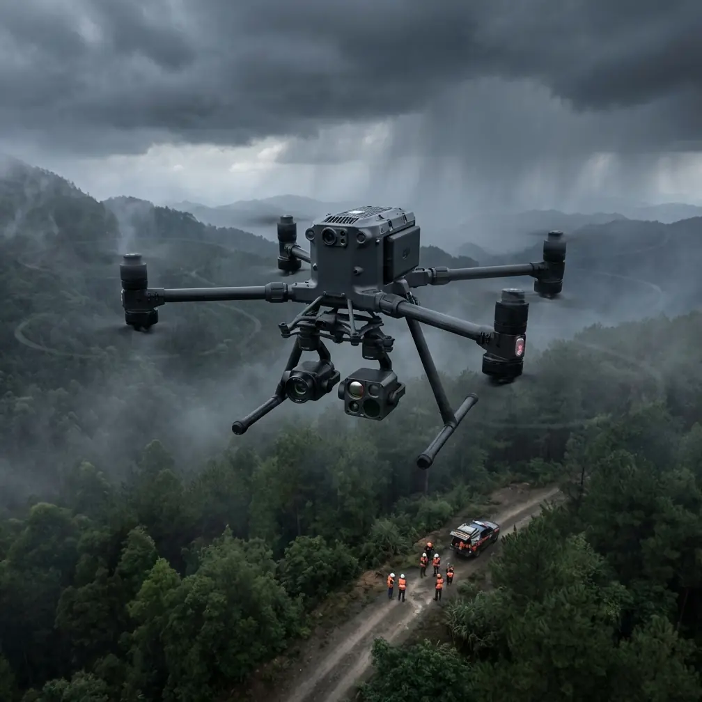
Coastal inspections frequently require identifying thermal anomalies across infrastructure that's difficult or dangerous to access on foot. The Matrice 400 supports DJI's Zenmuse H30T payload, which combines a 640×512 thermal sensor with a 48 MP visual camera in a single stabilized gimbal.
What Thermal Imaging Reveals Along Coastlines
- Structural delamination in seawalls and breakwaters where moisture infiltration creates distinct thermal signatures during morning heating cycles
- Underground pipe leaks near coastal treatment facilities, visible as thermal plumes in soil or sand
- Wildlife population surveys across tidal marshes, where animal body heat contrasts sharply against cool water backgrounds
- Electrical fault detection on coastal transmission infrastructure, identifying hot joints before salt corrosion causes complete failure
- Search and rescue support where thermal contrast between a person and open water reaches 15–20°C, making detection highly reliable
The key to accurate thermal signature capture in coastal environments is timing. Water's high thermal mass means it changes temperature slowly, while land and infrastructure heat and cool rapidly. The optimal inspection window is 60–90 minutes after sunrise, when infrastructure has begun absorbing solar radiation but ambient temperatures haven't yet equalized the scene.
Pro Tip: Set the Matrice 400's thermal palette to "Ironbow" for coastal infrastructure inspections. This palette provides the best visual differentiation between subtle temperature gradients on concrete and metal surfaces—particularly useful for identifying early-stage spalling in reinforced concrete seawalls where moisture intrusion is just 2–3°C cooler than surrounding dry material.
Photogrammetry and GCP Workflows for Coastal Mapping
Coastal erosion monitoring demands repeatable, survey-grade accuracy. The Matrice 400 supports photogrammetry workflows that produce orthomosaics and digital elevation models with sub-centimeter relative accuracy when paired with proper ground control point (GCP) strategy.
GCP Placement Challenges on Coastlines
Traditional GCP placement assumes stable, accessible ground. Coastlines violate both assumptions. Here's the adapted workflow:
- Use screw-in ground anchors rather than weighted targets on sandy or loose substrate—wind will relocate unsecured panels within minutes
- Place GCPs above the high-tide line and verify their position hasn't shifted between survey flights
- Deploy a minimum of 5 GCPs per mission area with at least one in each quadrant and one centrally located
- Record GCP coordinates using RTK-corrected GNSS with a minimum 180-second observation per point for tidal zone accuracy
- Mark GCP locations with semi-permanent markers (stainless steel pins) for repeat monitoring missions on erosion-sensitive cliffs
The Matrice 400's onboard RTK module provides 1 cm + 1 ppm horizontal accuracy and 1.5 cm + 1 ppm vertical accuracy when connected to a local base station or NTRIP network. For coastal erosion studies where you're measuring centimeter-level cliff retreat between quarterly surveys, this precision is non-negotiable.
Technical Comparison: Matrice 400 vs. Competing Coastal Platforms
| Feature | Matrice 400 | Competitor A | Competitor B |
|---|---|---|---|
| IP Rating | IP55 | IP43 | IP54 |
| Max Wind Resistance | 12 m/s | 10 m/s | 11 m/s |
| Transmission System | O3 (Triple-Channel) | Proprietary | Proprietary |
| Max Transmission Range | 20 km | 15 km | 12 km |
| Hot-Swap Batteries | Yes | No | Yes |
| Max Flight Time | ~47 min | ~38 min | ~42 min |
| Encryption Standard | AES-256 | AES-128 | AES-256 |
| RTK Support | Built-in | Accessory | Built-in |
| Thermal Payload Option | Zenmuse H30T (640×512) | 320×256 | 640×512 |
| BVLOS Readiness | Full compliance kit | Partial | Partial |
| Operating Temp Range | -20°C to 50°C | -10°C to 40°C | -15°C to 45°C |
The Matrice 400's combination of IP55 protection, hot-swap batteries, and O3 triple-channel transmission creates a decisive advantage for sustained coastal operations. Competitor platforms require mission interruption for battery changes, losing thermal sensor calibration and disrupting photogrammetry flight plans.
BVLOS Operations: Extending Your Coastal Reach
Coastline inspections are inherently linear—often spanning tens of kilometers of shoreline that cannot be covered within visual line of sight. The Matrice 400 is designed from the ground up for BVLOS compliance.
Key BVLOS-enabling features include:
- ADS-B In receiver that displays nearby manned aircraft traffic directly on the controller screen
- AES-256 encrypted command and control links that satisfy regulatory requirements for secure beyond-visual operations
- Redundant communication pathways through the O3 system, automatically switching between channels if one degrades
- Automated return-to-home protocols with configurable trigger thresholds for signal loss, low battery, and geofence breach
- Remote ID broadcasting compliant with current regulatory frameworks
Before planning BVLOS coastal missions, verify your national aviation authority's specific waiver or authorization requirements. The Matrice 400's technical capabilities meet or exceed the platform requirements for most BVLOS approval frameworks, but operational approvals depend on your complete safety case—including visual observer networks, detect-and-avoid procedures, and emergency protocols.
Common Mistakes to Avoid
Neglecting post-flight salt rinse protocols. Even with IP55 protection, salt crystallization on motor bells, gimbal mechanisms, and sensor lenses accelerates wear. Wipe down the entire aircraft with a damp freshwater cloth after every coastal flight. Pay particular attention to the gimbal's mechanical interfaces.
Flying photogrammetry missions at low tide without accounting for GCP datum. Your elevation model is only meaningful if you know its relationship to a tidal datum. Record the tide state at mission start and end, and reference your GCPs to a known tidal benchmark—not just an arbitrary WGS84 height.
Ignoring thermal sensor warm-up time. The Zenmuse H30T requires approximately 8–10 minutes of powered operation before thermal readings stabilize. Launching immediately and capturing thermal data during the warm-up period produces unreliable absolute temperature measurements. Power on the payload while completing your pre-flight checklist.
Using default camera settings for over-water photogrammetry. Water surface creates specular reflections that confuse photogrammetry software. Set your oblique camera angle to 15–20 degrees off-nadir when mapping areas that include water margins, and increase front overlap to 85% to give processing software more matching opportunities.
Skipping magnetometer calibration in new coastal locations. Coastal infrastructure often includes buried steel reinforcement, underground cables, and metallic dock structures that distort the local magnetic field. Calibrate the Matrice 400's compass at each new launch site, at least 10 meters away from any metal structures.
Frequently Asked Questions
How does salt air actually affect drone longevity, and does the Matrice 400 handle it better than consumer platforms?
Salt crystallization is hygroscopic—it attracts moisture from the air and creates a persistently damp, electrically conductive film on any surface it contacts. On unprotected drones, this causes motor bearing corrosion within 20–30 coastal flights, ESC board short circuits, and gimbal motor seizure. The Matrice 400's IP55 rating with conformal-coated internals provides meaningful protection, but it's not immunity. Operators who maintain disciplined post-flight cleaning routines report 500+ coastal flight cycles without corrosion-related failures. Consumer platforms in the same conditions typically show degradation after 50–80 flights even with careful maintenance.
What's the most effective flight pattern for coastal erosion monitoring with the Matrice 400?
For cliff-face erosion monitoring, use a double-grid pattern with oblique imagery. First, fly a standard nadir (straight-down) grid at 80% front overlap and 70% side overlap. Then fly a second pass with the camera angled at 45 degrees toward the cliff face. This captures the vertical surfaces that nadir-only missions miss entirely. Set your altitude to maintain a ground sampling distance (GSD) of 1.5 cm/pixel or better for detecting meaningful erosion between quarterly surveys. The Matrice 400's flight planning software supports automated oblique patterns, making this workflow straightforward to repeat consistently.
Can the Matrice 400 operate in rain during coastal missions?
The IP55 rating protects against water jets from any direction, which covers light to moderate rain and heavy spray. Operational flights in steady rain are technically possible from a hardware perspective. However, rain droplets on the camera lens degrade both visual and thermal image quality significantly. Photogrammetry data collected in rain produces measurably worse point clouds with higher noise. For inspection missions, light rain is workable if you use a lens hydrophobic coating and accept some image quality reduction. For photogrammetry and mapping missions, wait for dry conditions—the time spent reprocessing or reflying corrupted datasets always exceeds the time you'd spend waiting out a rain cell.
The Matrice 400 stands as the most capable platform currently available for sustained coastal inspection operations. Its combination of environmental protection, extended range, hot-swap endurance, and payload flexibility addresses every major challenge that coastal environments present. The operators who get the most from this platform are the ones who pair its hardware capabilities with disciplined field protocols—proper antenna positioning, rigorous GCP workflows, and consistent post-flight maintenance.
Ready for your own Matrice 400? Contact our team for expert consultation.